एथिपोथला झरना, आंध्र प्रदेश
नागार्जुन सागर में दो दिन के लिए होटल बुक किया था. एक दिन नागार्जुन कोंडा बुद्धिस्ट म्यूजियम देखने में लग गया और आधा दिन अनूपु गांव, जहां प्राचीन बौद्ध विश्वविद्यालय फिर से स्थापित किया गया है. कुछ समय था तो होटल वाले से पुछा कि और कोई देखने लायक जगह हो तो बताए. उसने कहा की आप के पास गाड़ी है तो आप वॉटरफॉल देख्न सकते हैं जो लगभग 15 किमी दूर होगा. बस गाडी उस तरफ दौड़ा दी. सड़क बहुत अच्छी नहीं थी पर आधे घंटे में पहुँच गए. सुन्दर स्पॉट है. आप भी देखिये:
https://jogharshwardhan.blogspot.com/2024/06/blog-post_6.html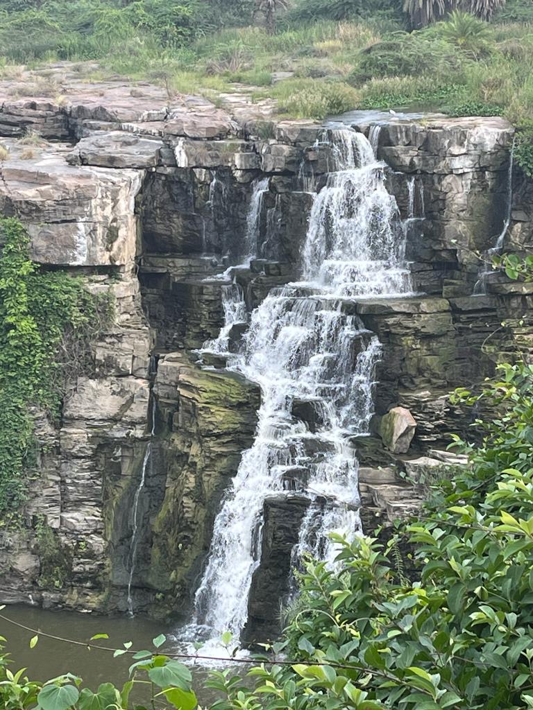 |
| 1. एथिपोथला जलप्रपात चन्द्रवंका नदी पर जिला पालनाडु, आंध्र प्रदेश में है. इस जलप्रपात का पानी सत्तर फुट से सीधा नीचे न गिर के चट्टानों पर गिरता हुआ झरना cascade बना देता है. यहाँ चन्द्रवंका नदी में नकला और तुमाला नामक छोटी धाराएं भी शामिल हो जाती हैं. इस झरने के बाद चन्द्रवंका नदी तीन किमी आगे चल कर कृष्णा नदी में मिल जाती है. मानसून में और उसके बाद झरने में ज्यादा पानी आता है और कई छोटे छोटे झरने भी बन जाते हैं. सुन्दर प्राकृतिक जगह है |
 |
| 2. प्रवेश के लिए टिकट है. अंदर आंध्र प्रदेश टूरिज्म का रेस्त्रां और व्यू पॉइंट भी है. नागार्जुन सागर से यह स्थान लगभग 15 किमी है. यहाँ एक मगरमच्छ फार्म भी है ( जो उस वक़्त बंद था ). |
 |
| 3. यह लम्बाडी आदिवासी महिला सभी पर्यटकों का स्वागत करती है हालांकि उसकी बात काम ही समझ में आती है. लम्बाडी आदिवासियों को बंजारा या सुगाली भी कहते हैं. आंध्र और तेलंगाना में काफी संख्या में रहते हैं. |
 |
| 5. झरने के पास ही दत्तात्रेय मंदिर है. नीचे मंदिर की ओर जाने का रास्ता |
 |
| 6. दत्तात्रेय मंदिर लम्बाडी समाज का मुख्य मंदिर है |
7. झरना और आसपास
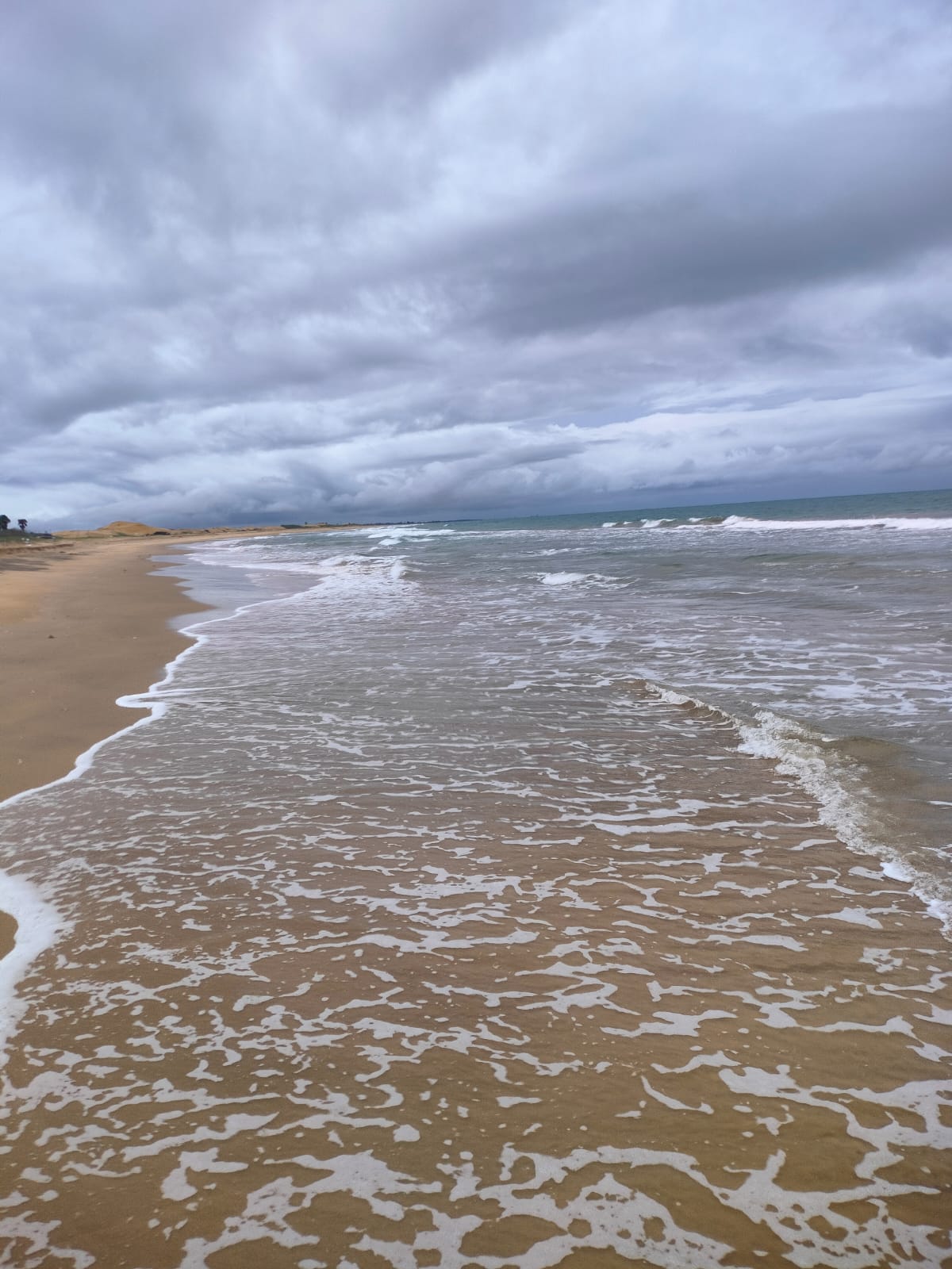
मछुआरों का गाँव - थुमलापेंटा आंध्र प्रदेश
 |
| 1. चेन्नई - कोलकाता राजमार्ग NH 16 के नज़दीक बसा मछुआरों का गांव थुमलापेंटा और बीच, जिला नेल्लोर, आंध्र प्रदेश |
बैंगलोर से वापसी यात्रा नेल्लोर होते हुए शुरू हुई. विजयवाड़ा जाने के लिए चेन्नई - कोलकाता राजमार्ग NH 16 पर आ गए. एक तरफ बंगाल की खाड़ी का समंदर और दूसरी ओर पूर्वी घाट की ऊँची नीची पहाड़ियां साथ साथ चल रही थीं. नेल्लोर से लगभग 70 किमी चलने के बाद कावली का बोर्ड नज़र आया जिस पर अधूरा सा 'Beach' शब्द नज़र आया. गाड़ी वहीँ मोड़ ली हालांकि बूंदा बांदी हो रही थी. आगे चले तो सड़क कम और सड़क पर ताल - तल्लैय्या ज्यादा नज़र आये ! गाड़ी चलाने में मुश्किल हो रही थी पर लुड़कते पुड़कते बीच तक पहुँच ही गए.
2. नेल्लोर-विजयवाड़ा रोड पर एक फ़ूड प्लाज़ा
 |
| 3. विजयवाड़ा की ओर जाता राजमार्ग |
 |
| 4. पूरे रास्ते में बादलों के तरह तरह से बदलते डिज़ाइन नज़र आते रहे ! |
 |
| 5. चॉकलेटी पहाड़ियां ! |
6. सी बीच
 |
| 7. थुमलापेंटा गांव में मछुवारों के जाल और नाव |
 |
| 8. लो आसमां झुक रहा है ज़मीं पर..... |
 |
| 9. केकड़ा जान बचाने के लिए शंख में छुपने की बेकार कोशिश कर रहा है. रेत में घुसता तो फिर भी बच सकता था. कौवे, चीलें और आदमी भी केकड़े के शिकार के लिए तैयार रहते हैं |
 |
| 10. सुहाना सफर और ये मौसम हसीं.... |
 |
| 11. ज्यादातर मछुआरे सुबह अँधेरे में ही समुद्र में जाकर जाल डाल देते हैं. धूप निकलते ही वापिस आ जाते हैं |
12. हिचकोले खिलाता गांव का रास्ता
 |
| 14. ठंडी हवा ने मूड बदल दिया ! |
 |
| 15. नमक की खेती |
 |
| 16. थुमलापेंटा बीच, आंध्र प्रदेश |
Amaravati, Andhra Pradesh
Amaravati is a historical Buddhist site located about 35 km from Guntur railway station in Andhra. It can also be approached from Vijayawada which is about 20 km away. Launches along the river Krishna are also available during rainy season or winter when the water level is higher. Neighbouring village of Amaravati is Dharnikota which was ancient site of Dhanyakataka, the capital city of later Satavahanas of second century CE.
The antiquity of Amaravati and Dharanikota goes back to early stone age. Area between Guntur and Amaravati has yielded a few urn-burials and tools of megalithic culture.
The Mahachaitya of Amaravati is the star attraction which was first discovered as earthen mound 20 feet high having a diameter of 90 feet in 1797 by Col. Colin Mackenzie. Subsequently excavations were carried out many times last being in 1973-74. Carbon dating revealed five periods of occupation of the site. Beginning of the settlement is said to be 5th century BCE.
A number of antiquities were recovered from Dharnikota, Alluru, Gummadidurru and Lingarajapalli. These include a gold necklace and five reliquaries. These reliquaries contained human bones may be of some senior Buddhist monks and gold flowers. This is a good place for students of ancient history and of Buddhist studies.
Amaravati has many Buddhist monuments and sculptures dating back to 3rd and 2nd centuries BCE. Many of these relate to Ashokan period ( reign 268-232 BCE). All these monuments and archaeological museum are at walkable distances in the middle of the town. It's a small town and has few budget hotels and many beautiful temples.
It can be visited from Vijayawada or Guntur in the morning and one can get back in the evening. Afternoons are hot here. We stayed in Vijayawada and had a to and fro same day trip to Amaravati. Next day also we had a re-look while going towards Nagarjunakonda en-route to Hyderabad.
Some photographs:
 |
| Remains of Buddhist Mahachaitya in Amaravati town, Andhra. As of now its height is about 2 m and diameter of 49.30 m. This is made up of large sized bricks measuring 57x28x7.6 cm and has wide paved Pradakshina-patha. It's construction was initiated during Ashokan reign in third century BCE. Subsequent changes and enlargements were made by Satvahanas, Ishvaku kings and Pallavas by adding sculptures etc |
 |
| Another view of Mahachaitya |
 |
| Large number of artefacts were found here during excavations by Archaeological Survey of India at differen times. Some of them are displayed here and in nearby local museum. Some others are displayed in museums of Chennai and London |
 |
| This stone slab shows Buddha teaching his disciples. During that period Buddha was shown symbolically by an empty chair, impressions of his two feet or Paduka or a Bodhi tree. Usage of statues came later during the reign of Indo-Greek kings and Kanishka in North-West of India that is Afghanistan and Pakistan region |
 |
| The site has smaller Chaityas and Stupas also surrounding the Mahachaitya |
 |
| This may have been parts of walls of meditation chambers may be |
 |
| Dome-slab showing Purna-kumbha. 1st - 2nd century, limestone. This slab was used in covering the dome of Stupa. Purna-kumbha is an auspicious symbol indicating fullness and contentment in life |
 |
| Inscribed pillar of Ashoka? 3rd century BCE in quartzite. This fragment was discovered 1958-59 from a house near Mahachaitya Amaravati. Text is in Brahmi script of Ashokan period and language is Prakrit. It is too fragmented to convey any coherent meaning |
 |
| Maithuna
Couple. 3rd century CE in limestone. Such loving couple is a celebrated
theme in Indian art. They are shown in sensuous posture exhibiting
pleasures of life. Metaphorical symbolism for human soul longing for
union with the divine |
 |
| Standing life size Buddha in human form with 'marks of great man' - Mahapurusha Lakshanas |
 |
| Dharma Chakra or Wheel of Dharma. 3rd Century CE. Recovered from Lingarajapalli district Andhra Pradesh |
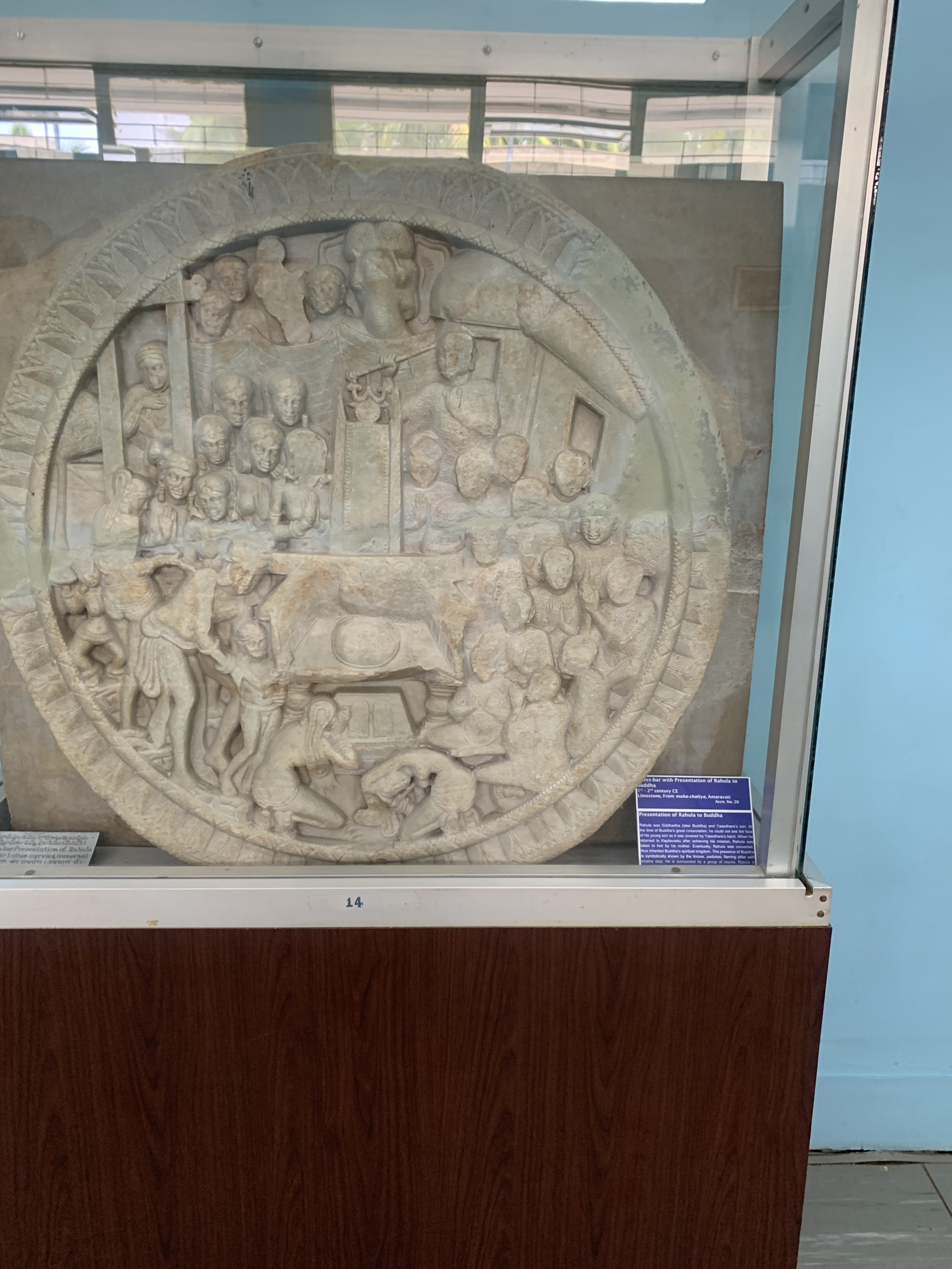 |
| Presentation of Rahul to Buddha. Yashodhara is seen here presenting young son Rahul to Buddha who has arrived to meet the family after enlightenment. Buddha is symbolically shown here as vacant throne with his two feet or Paduka. In limestone dated first - second century CE found in Mahachaitya Amaravati. |
 |
| Broken
statue of Gautam Buddha in Bhumi-sparsh Mudra or 'Touching the Earth'
Mudra. It symbolises the getting of enlightenment while sitting under
the Bodhi Tree |
 |
| Archaeological Museum Amaravati. Lots of such artefacts were recovered from nearby Mahachaitya Amaravati. On display in the museum |
 |
| Archaeological Museum, Amaravati, Andhra |
 |
| Buddha and his disciples! Nearby Buddha Vihar in Amaravati town has huge statue of Gautam Buddha. Hall beneath the statue has beautiful frescos depicting Jataka tales and events from the life of Buddha |
 |
| Buddhist Vihar as seen from the stairs near statue of Buddha |
 |
| Image of Acharya Nagarjuna, Buddhist philosopher famous for doctrine of Shunyavada postulated in his book Mulamadhyamakakarika. Statue has been donated by H.H. the 14th Dalai Lama. Situated opposite to the Museum and inaugurated by Tenzin Gyatso in 2006 |
 |
| On the way to Amaravati from Vijayawada |
 |
| A room with a view! View from the Hotel in Vijayawada |
 |
| Towards Vijayawada |
 |
| Outskirts of Vijayawada |
 |
| Dandi March statues in Vijayawada |
 |
| While in Vijayawada you can visit Undavalli Caves. Photo from the main cave: reclining Anant Padmanabha Swamy. This image has been carved from a single stone and is 5 m in length. Head covered with a seven-faced- hood of Naga |
 |
| Undavalli Caves in Vijayawada |
नागार्जुन कोण्डा
हमारी कार यात्रा विजयवाड़ा से अमरावती होती हुई नागार्जुन कोण्डा पहुंची. दो दिन का पड़ाव इस शहर के एक बजट होटल में रहा. नागार्जुन कोण्डा एक छोटा सा पर महत्वपूर्ण ऐतिहासिक शहर है. इसके मशहूर होने के कई कारण हैं. एक तो यहाँ बहुत बड़ा बाँध है जो कृष्णा नदी पर बना हुआ है. बाँध के साथ जुड़ा हुआ विशाल जलाशय है जिसका नाम नागार्जुन सागर है. इसमें पानी का फैलाव - FRL 285 Sq Km है. सागर के बीच में पहाड़ियां भी है और मुख्य पहाड़ी याने कोण्डा का नाम नागार्जुन कोण्डा है. इस कोण्डा के ऊपर एक बहुत बड़ा म्यूजियम, स्तूप और बाग़ बगीचे हैं जो देखने लायक हैं.
प्राचीन समय में यहाँ नागार्जुन कोण्डा में और आसपास के शहरों में जैसे की अमरावती, धरणीकोटा और विजयपुरी में बहुत से बौद्ध स्तूप, विहार और विद्यालय भी थे. इस कारण से बाँध का काम पूरा होने से पहले यहाँ पुरातत्व विभाग ने बहुत बड़े इलाके में खुदाई की. यहाँ से सैकड़ों सिक्के, एक विश्वविद्यालय, स्तूप, बौद्ध मंदिर या चैत्य और विद्यार्थियों के हॉस्टल के ईंट, पत्थर और मूर्तियों को निकला गया और उन्हें ऊँचे स्थान पर फिर से स्थापित किया. बहुत से अवशेष म्यूजियम में सजा दिए गए. विश्वविद्यालय और एक बड़ी खुली नाट्यशाला (या amphitheatre) को अनूपु गांव में स्थापित कर दिया गया.
यह जगह नागार्जुन के नाम पर है जो की पहली / दूसरी शताब्दी के एक महान बौद्ध दार्शनिक, लेखक और तर्कशास्त्री थे. उनकी लिखी किताबों में से एक मूलमध्यमककारिका ने बुद्ध के प्रवचनों की पुष्टि की. साथ ही बुद्ध के सूत्रों पर आधारित दार्शनिक निष्कर्ष 'शून्यवाद' का प्रतिपादन किया. बाद में बौद्ध सम्प्रदाय 'महायान' इसी व्याख्या को लेकर बना. बाद में महायान बौद्ध सम्प्रदाय तिब्बत, चीन कोरिया और जापान तक फ़ैल गया. मूलमध्यमककारिका इन देशों में अब भी काफी प्रचलित है.
प्राचीन काल में यह इलाका आन्ध्रा या आंध्र-देश कहलाता था. आंध्र-देश का इतिहास भी कम रोचक नहीं है. सम्राट अशोक के बाद में यहाँ सातवाहन, इक्ष्वाकु, पल्लव, चालुक्य, काकातिया, दिल्ली सुल्तान, विजयनगर राज्य, क़ुतुब शाही, मुग़ल और अंत में ब्रिटिश का राज या प्रभुत्व रहा.
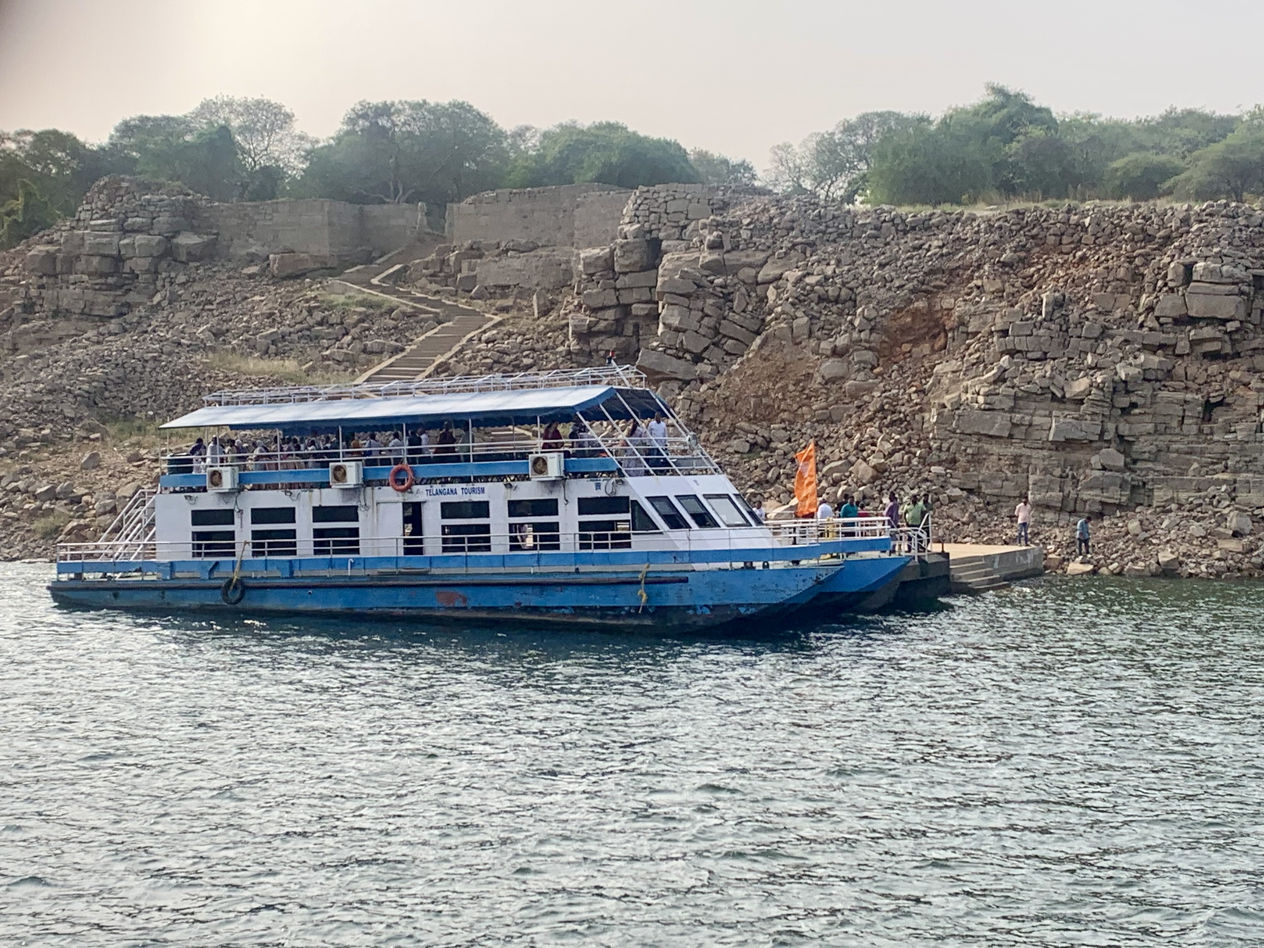
शहर से कोण्डा म्यूजियम पहुँचने के लिए केवल सागर फ़ेरी ही एक साधन है. उसमें भी लगभग 40+40 मिनट आने जाने में लग जाते हैं. छोटी नौका या स्पीड बोट उपलब्ध नहीं हैं. फ़ेरी भी तब चलती है जब ठीक ठाक संख्या में यात्री जमा हो जाएं. हमें काफी इंतज़ार करना पड़ा. एक बौद्ध ग्रुप तवांग, अरुणाचल प्रदेश से अचानक वहां आ पहुंचा जिसके कारण म्यूजियम जाना संभव हो पाया. नौ बजे से शाम पांच बजे तक तेज़ गर्मी होती है. टोपी, तौलिया और पानी का इंतज़ाम जरूरी है. नागार्जुन कोण्डा और आस पास के कुछ चित्र प्रस्तुत हैं.
 |
| 1. चलिए नागार्जुन कोण्डा म्यूजियम देखने |
 |
| 2. फ़ेरी की सवारी मज़ेदार है |
 |
| 3. नागार्जुन सागर के बीच में पहाड़ियाँ भी हैं |
 |
| 4. यहाँ की चट्टानों का रंग-रूप अलग है |
 |
| 5. पंचमुखी नाग राजा मुचिलिन्दा |
 |
| 6. चौकोर नक्काशीदार स्तम्भ. तीसरी शताब्दी का साक्य चित्रण |
 |
| 7. गौतम बुद्ध देवों को उपदेश देते हुए |
 |
| 8. तीसरी सदी का प्राकृत लेख |
 |
| 9. तीसरी/चौथी शताब्दी का लाइमस्टोन पैनल जिसमें सिद्धार्थ गौतम बुद्ध का जन्म से महापरिनिर्वाण का चित्रण किया गया है |
 |
| 10. तीसरी सदी, लाइमस्टोन से बना स्तूप - फलक, अग्नि स्कंध, बोधि वृक्ष, धम्म चक्र और आसपास यक्ष |
 |
| 11. तीसरी सदी की गौतम बुद्ध की खंडित मूर्ति |
 |
| 12. तीसरी सदी का प्राकृत में लिखा स्तम्भ. राजा श्री विजय सतकन्नी के राजकाल के छठे वर्ष में बनाया गया. अभिलेख का अनुवाद :- * Namo Bhagvato Agapogalasa, * Rano Gotamiputasa Siri Vijaya Satakanissa * Sava 6 gi pa diva Vesakha punima |
 |
| 13. नागार्जुन कोंडा पर पुनर्निर्माण कर के बनाया गया स्तूप |
 |
| 14.
दो मीटर ऊँची मूर्ति जिसके माथे पर एक गोल निशान है जिसे
'महापुरुषा-लक्षणा' कहा जाता है. सलवट वाली चादर या संघटि सुंदरता से बनाई
गई है. दाहिना हाथ शायद अभय मुद्रा में रहा होगा. तीसरी शताब्दी में बनी
मूर्ति अमरावती, आंध्र प्रदेश से प्राप्त हुई थी |
 |
| 15.
नागार्जुन कोंडा आने जाने के लिए तेलंगाना सरकार की फ़ेरी. आंध्र सरकार की
फ़ेरी अलग चलती है. ऊपर कोंडा घूमने के लिए गोल्फ कार्ट मिल सकती है. इस
पहाड़ी के ऊपर म्यूजियम भी है जहां खुदाई में प्राप्त वस्तुएं रखी गई हैं |
 |
| 16.
कृष्णा नदी पर बना नागार्जुन सागर बाँध. 1955 में इस बाँध की नींव
तत्कालीन प्रधान मंत्री नेहरू द्वारा रखी गई थी. बाँध 1967 में चालू किया
गया. बाँध का कुछ भाग जिला नलगोंडा, तेलंगाना में और कुछ जिला पालनाडु
आंध्र प्रदेश में है |
 |
| 20. नीले पानी के बीच लाल निशान नागार्जुन कोण्डा दर्शाता है |
 |
| 21. पास ही एक गांव चिंताला टांडा में गुरुद्वारे का झंडा दिखाई पड़ा. पूछने पर मालुम हुआ कि फूल सिंह नामक सिख अनुयायी ने ये गुरुद्वारा बनाया है और अंदर गुरु ग्रन्थ साहिब भी सही तरीके से सजा कर रखा गया है. यहाँ से बिदर और नांदेड़ की तरफ जाते हुए कई आदिवासियों से मुलाकात हुई जो कई दशकों पहले सिख बन गए थे |
 |
| 22. हाईवे सबके लिए है! इस तरह के काफी दृश्य देखने को मिले |
Gooty European Cemetery

It’s one of my passions as a blogger to visit old cemeteries and dig out history from each of the tomb and epitaphs. For me, each of these tells a story which needs to be told, forgotten with time I hope to bring back some of the interesting characters that once had a legacy which needs to be reminded. I had traveled to Gooty as a part of a tourist circle covering Belum Caves – Gandikota Gorge – Gandikota Fort – Gooty Fort. It was at Gooty that we have this famous hilltop fort which I have already blogged about and at the foot of the hill is this European Cemetery.
After the defeat of Tipu Sultan, the forces of East India Company looked to consolidate all the southern principalities and Gooty was one of them. The strategic position of Gooty fort at a hilltop resulted in a fierce battle and commanding that was Lieutenant-General Sir Thomas Bowser (1749-1833). Gooty Fort was captured by Lt. Col. Bowser’s detachment in August 1799, this battle resulted in some casualties and it was these dead soldiers and officers that were first buried at this European Cemetery.
How to Reach Gooty European Cemetery
Most trains traveling from Mumbai going down south towards Bengaluru
or Chennai stop at Gooty. This station has only two platforms adjoining
each other. One for the down train and the other for up train. Once you
get down at the station take the foot over bridge and exit the station.
This station has a monkey infestation and sometimes these can become a
bit violent if they spot food packets in your hand so it’s better to
hide them else they might come to snatch it from you.
Where to Stay at Gooty?
Gooty has limited options and I managed to only see three hotels
where you can stay overnight with only one amongst the three
recommendable. Even the locals will tell you that Hotel Ravi Theja
is the best place with air-conditioned accommodations in the town. The
only downside is that the hotel rooms do not have western toilets and
you would have to get yourself accustomed with the Indian version. On
the positive side, this hotel has a restaurant attached which takes care
of your hunger problem. However, the taste of food is not that great
and the saving grace would be that there are quite a few restaurants all
around this place serving both veg and non-veg food.
Local Transport at Gooty
From Gooty station you will find plenty of Auto and Vikram plying from the station towards the main town. Gooty station is a bit far (nearly 5 kilometers) from the main Gooty town thus this is the only viable option. A fully booked auto will cost you around 60 Rs. and takes around ten minutes to reach the hotel. Since this is a small town thus all the auto drivers know all the hotels in town so sit back and enjoy the short ride from the station to your hotel.
You can opt for the share Vikram also which would cost you around 10 Rs. per person. If you have luggage with you then traveling on a shared transportation can sometimes become bit difficult.
To travel to Gooty Fort from the hotel you need to take an Auto costing around 40 Rs.
Since the fort is not frequented by tourists thus for the return trip
you would also require a transportation. For this take down the mobile
number of the Auto driver and inform him that you will call him once
back from the top. Since Gooty is a small town thus it will hardly take
him a couple of minutes to reach back.
Visiting Gooty European Cemetery

This is a small cemetery located at the foothill of the Gooty Fort. This section is very well maintained and protected by a boundary gate and a gate. The cemetery is open to the visitor from 9 AM to 5 PM and its daily maintenance is taken care by a lady. Surprisingly she is quite knowledgeable and will happily guide you to the most important tomb that of Major-General Sir Thomas Munro.


By the looks of the tombs it is very clear that this place has recently been renovated and restore but what has been lost in time will never be able to be restored. Almost all of the tombs have no tablet stone or any marker and the ones that do have are almost illegible. Luckily Lal Bahadur Shastri Academy of Admiration in Mussoorie had a copy of a book which had a detailed list of tombs and inscriptions. The list that you will find below has been copied from that book.
Apart from this list which mostly comprises of people who had died during the battle the cemetery also at a later point in time had tombs of European officers and their family including those of children who had died at Gooty or nearby towns. Mostly these families had settled here in India while serving East India Company and later the British Empire.


The most famous of all the tomb is that of Major-General Sir Thomas Munro. While reading old documents which were mostly created during the British Empire praised Munro to such an extent that they even declared that songs in his praise were sung by the villagers for decades after his death. Initially, I assumed that these were just propagandas but the search also revealed a recent article on an e-newspaper dated 2017 that the Additional Joint Collector of Anantpur district along with other dignitaries garlanding a statue of Thomas Munro celebrating his 257th birth anniversary.
It is then I found that Thomas Munro had indeed done a lot of good work which included building irrigation tanks for the villagers, introduced Ryotwari Tax which took away the middleman and was also the collector of this region from 1800 – 1807. He died at Puttakonda due Cholera while traveling around this region.
These are the list of recorded burials at the site. At the moment only a few of them are visible do not know what happened to the rest. The below set of record is from the archive.
Captain Hadder Roberts
(On 24th July 1799 Captain Hadder Roberts was killed at Ghooty Fort.)
He entered the army as cadet in 1781, was made Lieutenant August 21, 1790, and Captain April 6, 1799.
Joseph Taylor
(Lieutenant Joseph Taylor, 12th Native Infantry, died at Ghooty, December 14, 1800.)
He entered the army as cadet in 1795. He was made Lieutenant on July 13, 1797.
George Dade
(At Gooty died of the wounds he
received in action with the Poligars Lieutenant George Dade, 4th
regiment native cavalry, December 25, 1801.)
He entered the cavalry in 1798. He was made Lieutenant on June 17, 1800.
Charles Palk
(Lieutenant Charles Palk of the 2nd Native Infantry, died at Gooty, December 14, 1802)
He entered the army as cadet in 1799 and was made Lieutenant on December 15, 1800.
Archibald Mossman
(At Gooty, Major Archibald Mossman of His Majesty’s 73rd Regiment, April 1803.)
Robert William Davis
(Captain Robert Davis of the 2nd Battalion 19th Native Infantry died at Gooty, 16th December 1805.)
He entered the army as cadet in 1795, was made Lieutenant on November 29, 1797, and Captain on September 21, 1804.
Richard Charleton
(Captain Richard Charleton of Artillery died at Gooty on May 12, 1806.)
He entered the artillery as cadet in 1792, was Lieutenant June 1, 1796 and Captain November 7, 1803.
George Butcher
(Ensign George Butcher, 21st Native Infantry, 20th April 1808.)
He entered the army as cadet in 1806, was made Ensign on July 3, 1807.
William Fair
(Lieutenant William Fair, 21st Native Regiment, died 14th January 1811 at Gooty.)
He entered the army as cadet in 1799 and was made Lieutenant December 15, 1800.
George Johnston
(Captain George Johnston of His
Majesty’s 34th Regiment of Foot, died at Gooty after an illness of four
days in the 44th of his age in the month of May 1811. [25 years of
service.])
An officer who on every occasion during 25 years’ service,
had evinced that he possessed the zeal and spirit of a gallant soldier.
His wife died at Gooty on 31st August 1809. Lieutenant George Johnston
married, April 19, 1793, Miss Mary Close.
Alexander McDonald
(Alexander Alexander McDonald, Ensign 2nd Battalion, 15th Regiment, N.I., aged 23 years. Died 1815)
He entered the army as cadet in 1806 and was Ensign on July 3, 1807.
Maginnis
This monument is erected by the officers
of H.M., 69th Regiment tor the memory of Captain T. Maoinnis who died
suddenly at this place, aged 32 years. 1816
James Miller Young
(J. M. Young, Esq., Surgeon, aged 26 years. This tomb is erected by a friend. Died 1820)
He was Assistant Surgeon to the 1st Battalion, 16th Regiment, N.I. He died on his route to the southward.
")
")
")
")
")
")
")
")
")
")
")
")
")
")
")
")
")
")
")
")
")
")
")
")
")
Peter Bruce
(Peter Bruce, Esq., First Judge of the Provincial Court of the Centre Division, who died on circuit at Gooty 1821.)
He
was writer in 1796. He was connected with the district for more than
twenty years, and gave him name to the Brucepettah at Bellary.
Alexander Ord
(Ensign Alexander Ord, aged 18
years. This monument is erected by officers of the 1st Battalion, 3rd
Regiment N.I., as a testimony of their esteem and respect. Died 1822)
Youngest son of John Ord, Esq., of Torradale. He joined the army as cadet in 1820 and was Ensign February 13, 1821.
William Grant Gordon
(William Grant Gordon,
Lieutenant and Adjutant 20th Gordon. Regiment, Madras Army, who fell a
victim to cholera morbus in the 24th year of his age. Died 1824)
This tomb is erected and this epitaph inscribed by his beloved brother, Ensign George Gordon, 48th Regiment.
George Robert Gosling
(George Robert Gosling,
Esq., of the Madras Civil Service, aged 25 years. This tomb is erected
by his brother H. C. Gosling, Lieut., 7th Regt. M.N.I. Died 1825)
He died at Anantapur while Acting Head Assistant to the Magistrate and Collector of Bellary.
Frederick Benjamin Griffith
(F. B. Griffiths, Lieutenant and Quarter Master, 42nd Regiment N.I., aged 24 years. Died 1827)
He joined the army as cadet in 1819 and was made Lieutenant on April 7, 1820.
Arthur Wilmot
(Arthur Wilmot, Esq., of the Madras Civil Service, aged 21 years. Died 1827)
He
was writer in 1824. Edward Cornwallis Wilmot, B.C.S., probably his
brother, died at Calcutta, December 23rd, 1826, aged years. )
Archibald MacLeod
(Captain Archibald MacLeod of
tho 43rd M.N.I. , who 1827. died of spasmodic cholera at Ramdospet near
Ghooty, aged 34 years and 35 days)
Commandant of the late Honourable the Governor, Sir Thomas Munro’s escort.
Francis William Robertson
(Francis William
Robertson, Esq., 32 years, a member of the 1838. Robertson. Civil
Service and 15 years Principal Collector of Bellary, who died at
Anundapoor, aged 59 years.)
His zeal in promoting the welfare of the
district over which he presided was indefatigable and will be remembered
so long as the numerous plantations which he planted and which had
gained for him a well-deserved fame continue to flourish. His memory is
still affectionately revered and the munificence and benevolence of
“Rob.” Sahib is still the favourite theme among the old members of a
village community. He joined service as writer in 1806
Grave of Major-General Sir Thomas Munro
(Major-General Sir Thomas Munro, Bart, and k.o.b., Governor of Madras, died at Putticondah on the 6th July 1827) Was interred at Gooty on the 7th idem. His remains were afterward removed to the seat of Government, and deposited in St. Mary’s Church, Fort St. George.


While researching I also found this interesting document that talks about the popularity of Major-General Sir Thomas Munro.
It is interesting to note that a distinguished Englishman ranks among the mahatmas or demi-gods who used their influence for the lasting good of India. The name of Sir Thomas Munro is still ringed with the halo of divinity by the people of the Cedod Districts, whose Principal Collector he was during the stirring times of the East India Company.
Stories are still told of Munro’s justice and magnanimity and ballads sung in his honour. The incident that won for him a mahatma’s niche in the people’s imagination, writes ” Walrus ” in the ** Madras Mail M , is thus related in the annals of Bellary. Mantasala, a little village on the bank of the Tungabudra, which is famous as containing the tomb of the Madhva saint, Sri Kaghavendraswamy, and attracts annually a large number of pilgrims from Bombay and the Nizam’s Dominions and even from Mysore. The land endowment connected with this tomb being threatened with resumption, Munro, it is said, came to make inquiries. “After removing his boots and taking off his hat he approached the grave. The Saint there upon emerged from his tomb and met Munro.
They conversed for some time regarding the resumption, but though the saint was visible to Munro, none of the others who were there could either see him or hear what he said. The discussion ended and Munro returned to his tents and quashed the proposal to resume the endowment. Being offered some consecrated rice, he accepted it and ordered it to be used for the preparation of his meals for that day.” Munro is supposed to have contributed to Ids election to mahatmaship by possessing arms ” so long that they reached to his knees ” and in tins respect resembling the divine heroes of the Indian epics.
Munro died of cholera while on tour in his beloved Ceded District. The story goes that shortly before his death he was riding through a pass in the ghauts and imagined that he saw a garland of flowers stretched across the valley. This optical delusion is believed by the natives to have been a presentiment. At Pattikonda, Government constructed a tope and tank to his memory; and at Gooty is the Munro choultry, within which hangs an engraving of Sheo’s full length portrait, copies of which also adorn the cutcherriea at Bellary and Cuddapah.
Munro was known in the Ceded Districts under the appellation of the Father of the People ; and in the village of Bellaguppa, Rayadrug taluk, Bellary district, the eldest sons of a shepherd’s family were till recently named after him Munrolappa. Many local ballads were composed in his honour, some of which are still sung. Munro Bridge, Chetput, was named after Sir Thomas Munro, during whose Governorship it was built. Sir Thomas Munro’s house and a wall in the compound in Anantapur are preserved now by Government as ancient monuments.
There was also this copy of a letter which Major-General Sir Thomas Munro wrote to his mother.
Munro writes [to his mother 17th May 1795] : — ” I remember I left Cassirncottah about eight years ago, on account of the danger of hill fevers, but a stronger reason was that I could not live without playing fives.” He frequently used to, say that I would rather live on half pay in a garrison that could boast of a fives court than vegetate on full batta, where there was none.”
Overall my trip to Gooty was real fruitful as I managed to cover multiple sites like Belum Caves – Gandikota Gorge – Gandikota Fort – Gooty Fort and finally Gooty European Cemetery. Hope you have enjoyed this tour of this part of Andhra Pradesh, keep following Indian Vagabond see you soon in some place else till then Bon Voyage.

Action Camera Footage of Gooty European Cemetery
Route Maps around Gooty
Click here to open the route map to Gandikota from Gooty on Google Maps
Gooty Hotel Details
Gooty – Hotel Ravi Theja (Mobile – 83093 86360, this
is the mobile number of the owner who can speak Telugu and Little
Hindi. You can also WhatsApp him in this number in English)
Other nearby Tourist Attractions Near Gooty
Belum Caves – I have a separate detailed blog about this place click here to read.
Gandikota Gorge – I have a separate detailed blog about this place click here to read.
Gandikota Fort – I have a separate detailed blog about this place click here to read.
Gooty Fort – I have a separate detailed blog about this place click here to read.
Gooty Fort

In this region of Andhra Pradesh, the popular tourist destinations are Belum Caves and Gandikota. Gandikota is more famous for its Grand Canyon-like gorge than the fort which people visit as a side show. Unless you are travelling to these two places as a weekend getaway in your car you would need to stay somewhere and this is exactly where our next tourist destination comes. The name of the place is Gooty or I think I should call it Gutty as this is what the locals refer to this place as.
My trip to Gooty was part of a tour to Belum Caves – Gandikota Gorge – Gandikota Fort. Gooty is a small town and the railway station is one of the diesel loco shed in the line between Chennai and Mumbai thus there is a sizeable population of railway employees who reside in quarters all along the railways station. The main Gooty town is however around 4 – 5 kilometres from the station.
How to Reach gooty
Most trains travelling from Mumbai going down south towards Bengaluru or Chennai stop at Gooty. This station has only two platforms adjoining each other. One for the down train and the other for up train. Once you get down at the station take the foot over bridge and exit the station. This station has a monkey infestation and sometimes these can become a bit violent if they spot food packets in your hand so it’s better to hide them else they might come to snatch it from you.


Where to Stay in Gooty
Gooty has limited options and I managed to only see three hotels where you can stay overnight with only one amongst the three recommendable. Even the locals will tell you that Hotel Ravi Theja is the best place with air-conditioned accommodations in the town. The only down side is that the hotel rooms do not have western toilets and you would have to get yourself accustomed with the Indian version. On the positive side, this hotel has a restaurant attached which takes care of your hunger problem. However, the taste of food is not that great and the saving grace would be that there are quite a few restaurants all around this place serving both veg and non-veg food.

Local Transport around Gooty
From Gooty station you will find plenty of Auto and Vikram plying from the station towards the main town. Gooty station is a bit far (nearly 5 kilometres) from the main Gooty town thus this is the only viable option. A fully booked auto will cost you around 60 Rs. and takes around ten minutes to reach the hotel. Since this is a small town thus all the auto drivers know all the hotels in town so sit back and enjoy the short ride from the station to your hotel.
You can opt for the share Vikram also which would cost you around 10 Rs. per person. If you have luggage with you then travelling on a shared transportation can sometimes become bit difficult.
To travel to Gooty Fort from the hotel you need to take an Auto costing around 40 Rs. Since the fort is not frequented by tourists thus for the return trip you would also require a transportation. For this take down the mobile number of the Auto driver and inform him that you will call him once back from the top. Since Gooty is a small town thus it will hardly take him a couple of minutes to reach back.

History of Gooty Fort
The fortifications enclose a roughly circular of steep rocky hills which rise abruptly from the plains to a height of more than 680 meters feet above the sea level. These hills are connected by lower spurs enclosing a considerable area of level ground, within which is the old town of Gooty is situated. The ruins of a strong wall or rampart are strengthened by bastions. The citadel of the fortress is in the western most hill, which is conspicuously higher with elevated towers. The rock commands the lower fortifications and the town below which is defended by a series of ramparts built one above the other and connected by gateways flanked by bastions. Numerous small reservoirs made in the clefts of the rock catch the rain water seasonally and served well.
The summit of the citadel has two buildings which apparently, a granary and a powder-magazine. On the edge of a cliff, some 300 feet high is a small pavilion built of brick and plaster which is called ‘Morari Rao’s Seat‘ and present an excellent view of the town below. It is said that Morari Rao, the famous Maratha, used to sit and play chess or swing himself.

There are many other buildings in ruins, mostly granaries, storerooms, and magazines, and some of these were used by Munro as prisons for refractory hill Chiefs. Near the summit of the hill, on the rocks close to the ruined Narasimha temple, are eight inscriptions, but owing to their exposure they are seriously damaged. All that can be ascertained out of three of them is that they were of the period of Western Chalukya King Vikramaditya VI, surnamed Tribhuvanamalla, who ruled from 1076-1126 AD. It can be stated that the fort and the historical structures date back to Late Chalukyan Period.
After the death of Krishna Deva Raya, there was some turmoil in the Vijayanagara kingdom, Sadasiva Raya, a nephew of Achyuta was proclaimed as Emperor with the help of Adil Shahis. It was during Venkata II’s (1584-1614) rule the Gooty fort fell into the hands of the Qutb Shahis.
Aurangzeb captured Golkonda, he apparently took Gooty from Qutb Shahis. About 1746 A.D. Morari Rao established himself in the fort and eight years later he made it his permanent residence and repaired the fortifications. It is to this period that the stucco ornamentation of the small gateways belonged. In A.D.1775 Gooty was attacked by Haider Ali and sieged for five weeks the town and lower forts and two months later Morari Rao was compelled through lack of water to capitulate. At the foot of the hill is the European Cemetery, where rested the body of Sir Thomas Munro, who died of cholera at Pattikonda (Kurnool district) on the 6th July 1827.
(Above information from Arche logical Survey of India Hyderabad Circle)


Climbing to the Top of Gooty Fort
The short auto drive from the station to the Fort will take you across the small town and navigate around the small houses and temples you will reach the base of the hill.
Tip: Right at the foot of the hill before you climb there is a shop selling bottled water and carbonated drinks. Do stock up as the climb is steep and once up there are no shops.
At the base, you will see two cannons which act like a gate to the fort. To the left of the pathway that takes you up is the European Cemetery which remains open from 9 AM to 5 PM.


The climb at places is steep thus wear appropriate footwear. Take rests in between if you want there will be several boulders on the way where you sit for a while and catch your breath. While climbing up you will come across the Dargah of Hazrat Syed Basha, every year two days of Urs is celebrated in his honour on the 8th day after Milad-un-Nabi. This place can be a good place for you to take rest in between your climb up to the top. Right opposite to the Dargah you will find a small Muslim cemetery.


If you look back you will get a fantastic panoramic view of Gooty town from here, you will also be able to see the hill ranges all around. What you will also notice is that the fort walls extend to other hills around this central hill.


The climb after this is quite steep and after taking a sharp left turn you will see what appears to be the entrance to the fort. Right in front of you will be the tank and the granary to the left. Out here you will see other small room like structures which were probably magazine or residence. On the Eastern side you will be able to see the vast expanse of the valley below.


The structure which is most prominent is the Morari Rao’s Seat which looks to be the best-maintained building in the fort. Overall most of the structures inside the fort are in shambles and only some portion of either a gate or a wall remains. All around you will be able to see the watch towers strategically placed all around the hill.


Apart from the fort, the next interesting thing and ironically the best-preserved structure is the European Cemetery at the foothill. This is a very important and interesting place and this requires a detailed blog which I am going to post next. Till then bon voyage and have a good travelling experience.


Action Camera Footage of Gooty Fort
Gooty Fort Route Maps
Click here to open the route map to Gandikota from Gooty on Google Maps
Gooty Hotel Details
Gooty – Hotel Ravi Theja (Mobile – 83093 86360, this
is the mobile number of the owner who can speak Telugu and Little
Hindi. You can also WhatsApp him in this number in English)
Other nearby Tourist Attractions
Belum Caves – I have a separate detailed blog about this place click here to read.
Gandikota Gorge – I have a separate detailed blog about this place click here to read.
Gandikota Fort – I have a separate detailed blog about this place click here to read.
Gooty European Cemetery – I have a separate detailed blog about this place click here to read.
Gandikota Fort

Gandikota which is most famous for its Grand Canyon-like gorge has also another important tourist attraction which is the Gandikota Fort. The ruins of the fort and its structures lie right next to the gorge, in fact, the fort was purposely built in this location so that the gorge acts as a natural defense on one side. The different remaining structures inside the fort complex is spread out and if you want to see them properly then can take nearly half a day thus prepare and plan accordingly. Gandikota fort forms a part of the tourist circle which comprises of Belum Caves – Gandikota Gorge – Gandikota Fort – Gooty Fort.
How to Reach Gandikota fort
Tadipatri is the nearest train station from Gandikota but as per my
knowledge, there are no good hotels where you can stay unless of course,
you are coming to this place on a long drive from the nearby metro
cities. The best option as far as the hotel is concerned would be Gooty, which is also the logical choice since most people visit Gandikota along with Belum Caves and Gooty itself also has the famous hilltop, Gooty Fort.
Where to Stay at Gandikota Fort
Gooty has limited options and I managed to only see three hotels where you can stay overnight with only one amongst the three recommendable. Even the locals will tell you that Hotel Ravi Theja is the best place with air-conditioned accommodations in the town. The only downside is that the hotel rooms do not have western toilets and you would have to get yourself accustomed with the Indian version. On the positive side, this hotel has a restaurant attached which takes care of your hunger problem. However, the taste of food is not that great and the saving grace would be that there are quite a few restaurants all around this place serving both veg and non-veg food.
If you want to stay directly at Gandikota then APTDC Haritha Hotel
is the only option. On the downside, this place is completely
ill-prepared to host guests if you visit them without prior booking. We
wanted to have lunch at the restaurant inside the hotel out here since
this was the only place around the fort but we were told that the only
option for lunch would be fried rice and egg fried rice. The hotel staff
themselves admitted that it is only during the weekends that this place
springs into action with guests visiting else this place remains
completely vacant throughout the week thus they plan the food
availability accordingly.
Local Transportation around Gandikota
Considering that you are going to stay at Gooty you will find plenty of Auto and Vikram plying from the station towards the main town. Gooty station is a bit far (nearly 5 kilometres) from the main Gooty town thus this is the only viable option. A fully booked auto will cost you around 60 Rs. and takes around ten minutes to reach the hotel. Since this is a small town thus all the auto drivers know all the hotels in town so sit back and enjoy the short ride from the station to your hotel.
To reach Gandikota and Belum Caves you have to book a car since there
are no regular bus services on which you can rely. The car rates are 1000 Rs. for a day plus 300 Rs.
for the driver, fuel cost will be at actual at the rate of 10
Kilometres per litre of diesel. Roughly a trip to Gandikota including
Belum caves from Gooty would roughly cost you around 3000 Rs.
History of Gandikota Fort
The word Gandikota is actually derived from two words “Gandi” in fact means gorge and “Kota” means fort. The history of this place dates back to 12th century A.D. According to Khaifivat of Gandikota a certain chief Kapa Raja, a subordinate of Ahavamalla Someswara I, the Western Chalukyan king of Kalyana, founded Gandikota in 9th of January 1123 A.D. According to the same record, the Chief Kakaraja while on his way to Mulkinadu via Bellary and Gooty was impressed with the romantic landscapes like high cliffs and thick bushes and several water springs and along with the divine vision of Vishnu, he laid the foundations for the fort and ordered his architect Gurikandlu and Ayakandlu to build a fort in that place. He is also said to have built several bastions, which were called after the names of Ramabanamu, Virabhadrabanamu and Madhava Chakram, and several temples inside the fort.


timeline of the rulers of Gandikota fort:-
1123 – Kapa Raja
1309 – Invasion by Muhammadans
1336 – Kingdom of Vijayanagar by Harihara & Bukkarayalu
1352 – 1376 – Bukka I
Harihara Bukkaraju
Kaka Maharaju
1509 – Krishnarayalu
1544 – Nandyala Timmayadeva Maharaja
1546 – Nandyala Timmayadeva Naraparaju
1548 – Mahamandalesvara China Timmayadeva Maharaju
1549 – Naraparaju
1551 – Pina Avubhalamaharaju and Narapadeva
1552 – Timmayadeva
1557 – Timmayadeva and Pina Aubhala Maharaju
1574 – Narasimharaju
1597-98 – Nandyala Krishnamaraju
1642-64 – Sri Ranga III
1649 – Mir Jumla (attacked)
Fakir Khan
Nek Nam Khan
Md. Nabi Khan
Abdullah Nabi Khan (Mayana chiefs)
1777 – Hyder Ali (under Mir Jumaluddin)
1782 – Tipu Sultan
1790 – Nizam of Hyderabad
1800 – East India Company (Capt. Little)
Generic Structures inside Gandikota Fort
Once a thriving fort now only a few of the structures are visible, most of the boundary walls have either collapsed or simply vanished. The entrance to the fort, however, have been restored and some grandeur can still be felt as you drive past them. The ceilings are missing but the thick walls tell a story of a fort which has massive defences.


Visible Structures inside Gandikota Fort
LocationOf All The Important Structures Inside The Fort
Gandikota Fort – Charminar
This is possibly the most well-maintained structure still standing. By the design, you can clearly make out that this was meant to house pigeons. The numerous number of openings are still a place where you will find these pigeons pecking out its neck.


Gandikota Fort – Jail
To the left of Charminar is the Jail, Clearly understood by the massive windowless structure that this place once housed prisoners of the kingdom. You will still be able to see small openings in the wall which was probably built for air circulations in the cells below.


Gandikota Fort – Water Tanks
There are few tanks in the fort and while you approach Madhavaraya Swamy Temple you will be able to see one of them. The villagers have installed water pumps which draw water from these tanks and use them for cultivation around the fort structure. It is to be noted here that there is a substantial population of villagers live inside the fort walls thus you will see them all around. Up ahead there is perennial spring called Rayalacheruvu which according to historical records used to even supply water to the fountains of the mosque (Jama Masjid).


Gandikota Fort – Madhavaraya Swamy Temple
This is the grander of the two temples that exist inside the fort, this also happens to be the tallest structure in the fort premises. The gateway (Gopuram) of the temple is impressive with four-storeyed structures and with numerous intricate carvings. The main shrine inside is beyond a massive mandapa which has elaborately carved pillars and impressive ceilings. This was built during the reign of Krishnadeva Raya around 15th and 16th century.


Gandikota Fort – Mausoleum
This structure lies right next to the Jama Masjid, looking by its size and design it can be safely assumed that this was a Mausoleum for the Muslim rulers of the fort. Right opposite to this structure you will find some damaged building like structures from the fort that once stood here.


Gandikota Fort – Jama Masjid
This mosque was built by the Muslim rulers of the regions started conquering different forts in this part of the Indian subcontinent. The mosque was originally started by Mir Jumla after he successfully annexed this in the year 1649 however it was only completed by Nek Nam Khan years later. The main structure inside has three arches and two big minarets followed by smaller ones all around. The Mihrab inside this section still has some visible design patterns.


Gandikota Fort – Kathula Koneru (Pond of Swords)
This tank or pond is right in front of Jama Masjid. It is believed that the king and rulers of the fort used to wash their swords in the water of this pond after a battle thus it got its name Kathula Koneru.


Gandikota Fort – Granary
Right next to the Jama Masjid is the Granary. The structure looks similar to that of the Jail but a little smaller in size.


Gandikota Fort – Ragunatha Temple
This temple is in much-dilapidated state and also smaller in size. If you are visiting the Gandikota gorge then this temple will fall to your left. This was built during the reign of Krishnadeva Raya around 15th and 16th century.


Apart from these, there are other structures like Rani Mahal, Magazine, Gun Foundry, Talim Khana etc. which are spread all around the fort, these are in a damaged state thus do not expect a grandstanding structure. Lack of visitors to this region means that very less maintenance has taken place thus some portion of the fort is not easily accessible and one needs to carefully navigate through boulders.


Another attraction of this fort is the Grand Canyon-like gorge; I have already written a separate blog about it which you can read it here.

Action Camera Video Footage of Gandikota Fort
Gandikota Fort – Route Maps
Click here to open the route map to Gandikota from Gooty on Google Maps
Click here to open the route map to Gandikota from Gooty via Belum Caves on Google Maps
Click here to open the route map to Gandikota from Gooty via Belum Caves and return to Gooty on Google Maps
Gandikota Fort – Hotel Details
Gooty – Hotel Ravi Theja (Mobile – 83093 86360, this
is the mobile number of the owner who can speak Telugu and Little
Hindi. You can also WhatsApp him in this number in English)
Gandikota Fort – Local Transportation Details
Toyota Etios & Toyota Innova – Call Malli at 91000 91666, he can speak English, Hindi at Telugu
Other nearby Tourist Attractions
Belum Caves – I have a separate detailed blog about this place click here to read.
Gandikota Gorge – I have a separate detailed blog about this place click here to read.
Gooty Fort – I have a separate detailed blog about this place click here to read.
Gooty European Cemetery – I have a separate detailed blog about this place click here to read.
Gandikota – Travel Guide

For those of you who cannot see the possibility of visiting the Grand Canyon (Arizona) in the near future do not be saddened as the solution to your problem is right here in India. The solution is Gandikota, a small village located in the Kadapa district of Andhra Pradesh. Let me warn you from the very beginning that this is not an easy place to reach as this place has very limited connectivity from rest of the India except for places like Bengaluru, Chennai and Hyderabad from where you can simply drive off over a weekend. The best part, however, is that a trip to this place will let you cover two other interesting places which include Belum Caves – Gandikota Fort – Gooty Fort.
How to Reach Gandikota
By train, there are many small towns around Gandikota from where you can access this place namely Tadipatri, Gooty and Guntakal. The largest town amongst these three is Guntakal but its bit far from Gandikota and the nearest is Tadipatri but this town has almost no proper hotel or guest houses so your best bet would be Gooty, which is also the best choice if you plan to visit Belum Caves and Gooty Fort.
Some, however, prefer to visit this place by driving on a weekend en
route to Hyderabad or Chennai for them take the quickest route and you
can park at the APTDC Haritha hotel which is situated just at the gates
of Gandikota Fort.
Where to Stay in Gandikota
Gooty has limited options and I managed to only see three hotels where you can stay overnight with only one amongst the three recommendable. Even the locals will tell you that Hotel Ravi Theja is the best place with air-conditioned accommodations in the town. The only downside is that the hotel rooms do not have western toilets and you would have to get yourself accustomed with the Indian version. On the positive side, this hotel has a restaurant attached which takes care of your hunger problem. However, the taste of food is not that great and the saving grace would be that there are quite a few restaurants all around this place serving both veg and non-veg food.
If you want to stay directly at Gandikota then APTDC Haritha Hotel
is the only option. On the downside, this place is completely
ill-prepared to host guests if you visit them without prior booking. We
wanted to have lunch at the restaurant inside the hotel since this was
the only place around the fort but we were told that the only option for
lunch would be fried rice and egg fried rice. The hotel staff
themselves admitted that it is only during the weekends that this place
springs into action with guests visiting else this place remains
completely vacant throughout the week thus they plan the food
availability accordingly.
Local Transport around Gandikota
Considering that you are going to stay at Gooty you will find plenty of Auto and Vikram plying from the station towards the main town. Gooty station is bit far (nearly 5 kilometres) from the main Gooty town thus this is the only viable option. A fully booked auto will cost you around 60 Rs. and takes around ten minutes to reach the hotel. Since this is a small town thus all the auto drivers know all the hotels in town so sit back and enjoy the short ride from the station to your hotel.
To reach Gandikota and Belum Caves you have to book a car since there are no regular bus services on which you can rely. The car rates are 1000 Rs. for a day plus 300 Rs.
for the driver, fuel cost will be at actual at the rate of 10
Kilometres per litre of diesel. Roughly a trip to Gandikota including Belum caves from Gooty would roughly cost you around 3000 Rs.
Trip to Gandikota
Start early so that you can reach Gandikota post lunch, this is considering that you would travel to Belum Caves in the first half. In order to get the best view of the canyon, you need to visit when the sun is behind you thus second half is the best bet.
The car ride will take you through three states in Andhra Pradesh since all these spots are on crossroads between the three states. Gooty falls under Anantapur, Belum Caves falls under Kurnool and Gandikota falls under Kadapa district. This region of Andhra Pradesh is some of the driest regions thus agriculture is very limited, what you will do find are numerous cement plants and thousands of wind turbines installed on hill tops to power this industry.
Being a dry zone you are most likely to find clear skies and even a splash of rain would only last a couple of minutes. You will pass a couple of bridges over rivers but do not expect to see water as these have remained dry for many years.


Tourist Attractions at Gandikota
The main tourist attraction at Gandikota is the gorge, however, do keep some time in your hand to visit the Gandikota Fort which lies right next to the canyon. The fort was strategically built above the canyon as a song defensive position from where an attack was almost impossible.


The gorge is around 6.5 Kilometres long and the height from top to the river varies from 300 to 400 feet the distance between the two ends of the cliffs are approximately 600 feet. The red rock face clearly indicated that it’s mainly sandstone. The word “Gandi” in fact means gorge and “Kota” means fort in the local Telugu language thus the words together clearly mentions this place as the Gorge Fort or Gandikota.
Cars are allowed right inside the fort and you would need to park right next to the old mosque from where you have to approach the gorge viewpoint on foot. It is highly recommended you wear comfortable shoes with a good grip as to get the best of views you would have to walk over slippery boulders. If travelling in summer then a sun hat is a must, umbrellas can be difficult to manage as you may need to use your hands for balancing and holding on. If travelling with children do not leave them alone especially near the edge of the gorge as it’s a straight drop also occasionally some of the boulders on the outer edges either come loose or wobbles under human weight thus you need to be extra careful.


Gandikota Gorge
The higher you go from the edge of the gorge the better is the view but remember to climb according to your own strength as you have to climb down and this can become tricky sometimes. Lucky for me our driver was as enthusiastic as me thus he guided me to the top of the gorge to get the best view. He, in fact, insisted on going to a certain point to get the best viewing angle and honestly he was absolutely right.
Coming back to the gorge it is one of the most breath-taking landscape views that I have ever seen in India. I had earlier seen smaller gorge in West Bengal (Gangani) but trust me nothing compares to this. What I am told is that the real Grand Canyon in the USA is larger than this and what we see out here in Gandikota is just a slightly smaller version.
The faces of the gorge have a sheer vertical drop with green waters at the bottom which forms the Penna River. Luckily the check dam upstream ensures a presence of water in this section giving it a perfect ten in terms of a visual bouquet.


The beauty of this place is such serene that you forget the time and it was hours since we had our last meal but still, we never felt hungry. I would recommend you got to this place during weekdays as there are almost no tourists so you would spend time at this beautiful place with just the sounds of winds hitting you face as you watch the red cliffs play hide and seek with the shadows of the clouds above. The scenery is such that many local tourists were posing like Bahubali, they were happy to pose for my camera, don’t get fooled by the size of the stone its tremendously heavy and they were somehow holding on for me to finish clicking. The locals are very friendly and some young students enthusiastically translated signage written in Telugu for me.


APTDC Haritha Hotel
APTDC Haritha Hotel is the only restaurant which is located right outside the Gandikota Fort entrance. This place is huge and has ample parking space. There are many air-conditioned rooms where you can spend the weekend. This place also has an attached restaurant but the service is limited due to the low tourist turnout on weekdays. Only on weekends, this place sees an influx of tourists who come on a weekend drive.


Gandikota has another big attraction which is the Gandikota Fort which also has quite a few beautiful structures. All that in my next blog till then bon voyage.
Route Map to Gandikota
Click here to open the route map to Gandikota from Gooty on Google Maps
Click here to open the route map to Gandikota from Gooty via Belum Caves on Google Maps
Click here to open the route map to Gandikota from Gooty via Belum Caves and return to Gooty on Google Maps
Action Camera Video Footage of Gandikota
Gandikota Hotel Details
Gooty – Hotel Ravi Theja (Mobile – 83093 86360, this
is the mobile number of the owner who can speak Telugu and Little
Hindi. You can also WhatsApp him in this number in English)
Gandikota Local Transportation Details
Toyota Etios & Toyota Innova – Call Malli at 91000 91666, he can speak English, Hindi at Telugu
Other nearby Tourist Attractions
Belum Caves – I have a separate detailed blog about this place click here to read.
Gandikota Fort – I have a separate detailed blog about this place click here to read.
Gooty Fort – I have a separate detailed blog about this place click here to read.
Gooty European Cemetery – I have a separate detailed blog about this place click here to read.
Belum Caves – Travel Guide

I have traveled across the oceans, trekked in the mountains even drove around the deserts but what I have not seen is a real cave. This unfulfilled dream of mine came true when I had the opportunity to visit Belum Caves. Located in the Kurnool district of Andhra Pradesh in India. This trip forms a part of the tourist circle which comprises of Belum Caves – Gandikota Gorge – Gandikota Fort – Gooty Fort.
How to Reach Belum Cames
The nearest railhead is Tadipatri but it is recommended that you stay at Gooty instead since Gooty has better facilities for ease of travel. There are no hotels near the cave and APTDC only manages a Haritha restaurant at the site thus you have to stay at a hotel either in Tadipatri or Gooty.
If you are traveling by car then you can directly reach the cave site and park your vehicles right next to the restaurant.
Where to Stay at Belum Caves
Though Tadipatri is the nearest station to Belum Caves I decided to stay at Gooty instead thus would not be able to recommend any hotels at Tadipatri. The main reason why I opted to stay at Gooty was that Gooty Fort is also located right in the center of the town thus would be able to visit that place easily.
Gooty has limited options and I managed to only see three hotels
where you can stay overnight with only one amongst the three
recommendable. Even the locals will tell you that Hotel Ravi Theja
is the best place with air-conditioned accommodations in the town. The
only downside is that the hotel rooms do not have western toilets and
you would have to get yourself accustomed with the Indian version. On
the positive side, this hotel has a restaurant attached which takes care
of your hunger problem. However, the taste of food is not that great
and the saving grace would be that there are quite a few restaurants all
around this place serving both veg and non-veg food.
Local Transport Around Belum Caves
If you are staying at Gooty then once you come out of the station you will find plenty of Auto and Vikram plying from the station towards the main town. Since the main Gooty town is around 5 kilometers from the station thus you have to avail their service. A fully booked Auto will cost you around 60 Rs. and with a limited number of hotels in the region, you can rest assured that the Auto driver will take you straight to the hotel.
To reach Belum Caves you have to book a car unless you have another pre-booked option. The car rates (2017) are 1000 Rs. for a day plus 300 Rs. for the driver, fuel cost will be at actual at the rate of 10 Kilometres per liter of diesel. Roughly a trip to Belum Caves and Gandikota from Gooty would roughly cost you around 3000 Rs.


Day Trip to Belum Caves
Usually, tourists visit Belum Caves and Gandikota together and these two tourist sites are actually in different districts thus start early so that you have enough time to go around each of the places at a comfortable pace. It takes roughly a little more than an hour to reach Belum Caves and you would pass through some of the driest regions of the state with beautiful landscapes of red soil and hill ranges in the distance. Just relax and enjoy the drive, I would recommend that you take snacks, drinking water and juices along with you, trust me these will come handy later.


What to See At Belum Caves
As you approach the cave you will be able to a hill in the distance with the word Belum Caves spelled out, don’t be mistaken the hill has nothing to do with the cave but just a sort of advertisement. As you enter the site you need to park your vehicles near the Haritha Restaurant, if you are not carrying water I would highly recommend that you stock up from the restaurant since you will for sure need this once inside the cave. All around the site you will find blower fans running, these are nothing but sending fresh air down to the caves below and sucking out air from inside the cave. This is critical else you will not survive with the accumulation of carbon dioxide at the bottom.


This place is a ticketed site and an adult would need to pay 50 Rs. and for a child (5 – 10 Years) is 35 Rs. Foreigners have to pay a fixed price of 300 Rs. Though there are no official guides for the site you will for sure be approached by the local staff to be the guide. Usually, I do not take a guide at a tourist spot since I do my homework before going but I would definitely recommend you to take their service out here. The caves are a labyrinth of interconnected sections and instead of wasting hours trying to figure out the correct way it best to use their service. There are no official rates for the guide and a tip on 80 – 100 Rs. would surely bring a smile to their faces.
Alternately if you do not take a guide there is no need to worry, you will never get lost as hundreds of CCTV with night vision cameras installed inside the cave thus if you are in any distress you will be easily traceable. The entire length of the cave which is open for tourist access have strategically placed lights giving the cave a wonderful yellowing glow but at some places, the floor can be slippery and carrying a battery operated torch or your mobile phone light is recommended.


This portion is basically a warning if you are claustrophobic or physically not fit this place is not for you. If you have breathing difficulties then it’s best to avoid since at places it can be extremely stuffy. Another portion of advice though may sound rude but some portions of the cave have a very narrow passage thus if you are overweight think twice before attempting to enter the narrow passages, there are other wider approaches take them instead. During the rainy season, some portion of the cave has constant water flowing beneath your feet thus wear footwear that is best suited.
The air pumps above the ground strategically force in the fresh air inside the cave thus do take rest from time to time under these blower pipes, you will surely feel relaxed. It’s always advisable to carry water inside the cave as it can become very sweaty inside and a quick round of hydration might be helpful.

Inside the cave
After going past the ticket gate you would need to climb down a flight of stairs to reach the first entry point of the cave, out here if you look straight up you will see a natural circular opening and during monsoon rain water enters the cave from this section.
Overall the cave is the second largest cave system in India with a length of 3229 meters and at the deepest point, it goes to a depth of 46 meters. Out of the total 3229 meters, only 900 meters is accessible to tourists and a total tour of this section would take around one and half hours.


There are several sections inside the cave which have been named, the
names, however, are just imaginary and were given as an identification
marker rather than any historical significance. Some of the sections are
as follows:-
Belum Caves – Dhyan Mandir (Meditation Hall)
This section is near to the entrance. Initial excavation revealed Buddhist period artifacts thus it is assumed that Buddhist monks used to use this as a meditation hall. There is even a section that looks like a bed with a pillow to recline.


Belum Caves – Pillidwaram (Cats Gate)
A natural arch of stalactites formed in the shape of three lion heads.


Belum Caves – Kotilingalu Chamber
This section contains stalactite formations which are akin to Shiva lingams. It has one huge pillar formed due to stalactite and stalagmite joining together. These as mentioned before are more of an imagination in naming the sections during initial exploration.


Belum Caves – Saptasvarala Guha (Musical Chamber)
Saptasvarala Guha means a chamber of seven notes. The stalactite formations in this chamber reproduce musical sounds when these are struck with a wooden stick or knuckles. I would recommend you not to do this as it might damage the formations.


Belum Caves – Thousand Hoods
This section has amazing stalactite formations shaped like the hood of Cobra. The stalactite formations on the ceiling look as if thousands of cobras have opened their hoods.

Belum Caves – Banyan Tree Hall
This section has a huge pillar with stalactites hanging from the ceiling. This gives a look of Banyan Tree with its aerial roots when seen from below. The locals call it “Voodalamari” since it looks like a Banyan Tree with its aerial roots hanging from the branches.


Belum Caves – Mandapam
This is a huge area inside the cave with magnificent stalactite structures on the sides giving it a look of a hall with pillars.


Belum Caves – Patala Ganga
This is the deepest portion of the cave accessible to tourists. It is a small perennial stream which disappears into the depths of the earth. It is believed to be heading towards a well at the Belum village, located 2 km away from the caves.


Discovery of Belum Caves
The finding of Buddhist era pottery and artefacts suggest that this place was once used by monks as a resting and a place for meditation. This is also the reason why a section of the cave is referred as the meditation hall where monks used to rest and meditate.
Lost in time this place was discovered by Robert Bruce Foote who was a British surveyor in 1884. Later on, Robert Bruce Foote became an architect of geological and archaeological surveys in India. However, this cave was again somewhat forgotten and it was only in the 1980’s that a group of German speleologist led by Herbert Daniel Gebauer surveyed the cave and mapped it. Much later did this place become a tourist attraction when Andhra Pradesh Tourism Development Corporation decided to promote this place as a tourist destination.


At the Patal Ganga location, a new cavernicolous (inhabiting caves) Isopod species discovered, named Andhracoides gebaueri in the year 2013.

People usually visit Gandikota next which some say is the Indian answer to Grand Canyon, just an hour’s drive from Belum Cave Gandikota has quite a few attractions actually the gorge as well as the fort. All that coming up in my next blog till then bon voyage.

Action Camera Video Footage of Belum Caves
Belum Caves – Route Maps
Click here to open the route map to Belum Caves from Gooty on Google Maps
Click here to open the route map to Belum Caves from Gooty onward to Gandikota on Google Maps
Click here to open the route map to Belum Caves from Gooty onward to Gandikota and return to Gooty on Google Maps
Belum caves – Hotel Details
Gooty – Hotel Ravi Theja (Mobile – 83093 86360, this
is the mobile number of the owner who can speak Telugu and little
Hindi. You can also WhatsApp him in this number in English)
Belum Caves – Local Transportation Details
Toyota Etios & Toyota Innova – Call Malli at 91000 91666, he can speak English, Hindi at Telugu
Other nearby Tourist Attractions
Gandikota Gorge – I have a separate detailed blog about this place click here to read.
Gandikota Fort -I have a separate detailed blog about this place click here to read.
Gooty Fort – I have a separate detailed blog about this place click here to read.
Gooty European Cemetery – I have a separate detailed blog about this place click here to read.

.jpg)


No comments:
Post a Comment
Note: Only a member of this blog may post a comment.