Rani ki Vav

Rani ki vav, arguably the world's most impressive stepwell.
Simply put, Rani ki vav, or "The Queen's Stepwell," in the little
northern Gujarati town of Patan, is one of the foremost man made wonders
of India. The stepwell is generally thought to have been built by Queen
Udayamati of the Solanki dynasty as a memorial for her deceased
husband, Bhimadeva I, in the late 11th century. At the time, the
Solankis ruled over much of what we now refer to as the state of
Gujarat, and their reign is often viewed as a golden age in the history
of the region.
While the physical remains from the period are not great in number, the
few Solanki buildings which still exist are truly exceptional. Patan,
once known as Anhilwara, Anahillapura, Anahillavada, or any one of
several other names, was the capital of the Solanki kingdom, though the
vast majority of the traces of Solanki rule have long since been swept
away, starting in the 13th century when the city was sacked first by
Qutbuddin Aibak of the Delhi Sultanate, and then, later in the same
century, by his successor on the throne of Delhi, Allauddin Khilji. In
the 21st century, there is little in the dusty, unassuming little city,
other than the step-well of course, to remind one that Patan was once
the center of an empire.
That makes a visit to Rani ki vav all the more startling: In the middle
of nowhere, in a city which, though certainly not unfriendly or
particularly backwards nonetheless does not feel like it should have
ever been at the center of anything, one suddenly comes across one of
the most awe-inspiring man made sights in the country. This is in part
because the well was far more than a merely functional building. In
northwest India, where rainfall is scanty and water tables are deep on
account of the regions sandy soil, the building of a step well was
viewed as a meritorious act, and the wells themselves as places of
worship. It can also be said that the well, like all monuments, was a
means by which the Solankis could physically demonstrate their immense
wealth and power, something which it certainly does: Even when there are
so few remaining physical reminders of the Solankis existence, Rani ki
vav all by itself indicates that theirs was an age of incredible
artistic prowess.
Rani ki vav is to step wells what the Taj Mahal is to tombs and what
Mehrangarh Fort is to fortresses. While there may be larger step wells
in India, there aren't many, and those that are don't boast anything
approaching the almost hallucinogenic profuseness and technical skill of
Rani ki vav's incredible carvings. Yet, it seems that because
stepwells are a relatively obscure form of architecture, Rani ki vav
will remain relatively little known well into the foreseeable future
(despite the having having been made into a UNESCO world heritage site
just earlier this year.)
For centuries, the well was abandoned, during which time it filled
almost entirely with silt. Much of what remained above ground by the
19th century was carted off and used as building materials for other
constructions. It wasn't until 1986 that the A.S.I. began the process of
excavating and conserving the monument. Given how little care the
stepwell has received since the 13th century, it's a wonder that there's
anything left at all. Yet, even in its ruinous condition, Rani ki vav
projects an incredible opulence, and nearly a thousand years ago, when
the building had yet to face the ravages of time and Muslim invaders, it
must have been among the very grandest sights in India.

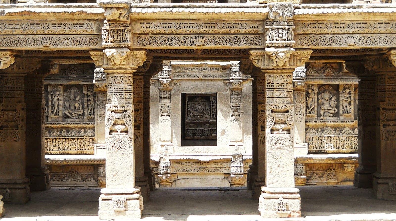
Looking into the step well. In its original form, the well would have
had seven terraces, each on a separate level, along with a large torana,
or ceremonial gateway, and so would have looked very different from
what you see here. There would have been considerably more shade inside,
and the lowest levels would receive very little direct sunlight except
in the middle of the day. Over time the torana has disappeared,
and the uppermost terrace has been stripped away, leaving only remnants
of the lower six. While even after a millennium of neglect the sheer
quantity of sculpture within the step well is an amazing thing to see,
when it was built Rani ki vav apparently contained close to twice as
many statues. At the back, or western, edge of the construction is the
primary well shaft, the deepest part of Rani ki vav, which is now
annoyingly off limits to the public. This was dug deep enough to allow
access to the water table of the Saraswati River, which even as late as
the 1980s still replenished the well, though the shaft has since gone
dry. In front of the well shaft is a rectangular reservoir. A long
flight of steps, with seven separate landings for each terrace, leads up
from the reservoir, while two small secondary staircases (both, again,
out of bounds) lead down from just in front of the well shaft. When the
stepwell was still filled in with silt, the only thing in the picture
above that remained unburied was the topmost few meters of the well
shaft. Until the 1980s virtually all of the statues and columns pictured
here were underground, encased in silt.
As a tourist site Rani ki vav leaves much to be desired. Visiting the
step well is frustrating, as no matter where you're going in Gujarat,
getting to Patan requires quite a long detour, and once you get there,
you find that much of the actual structure is blocked off and, even
worse, impossible even to see. One can go some of the way down into it,
but an awkwardly placed railing not only prevents you from going
further, but also stops you from getting a view of the most impressive
parts of the step-well (a problem which could be easily fixed if the
A.S.I. would simply move the railing forward a few feet.) Both the main
reservoir and the well shaft, the two deepest and therefore most
impressive parts of the building, are off limits. My experience of
visiting was made more annoying by a security guard who insisted on
being an impromptu and largely ignorant ("This vav is 5000 years old")
guide in order to try and get rupees out of me...The really was no
getting away from him either, given it was just him and me down in the
pit at 11 A.M...no other tourists were willing to brave the heat...
Still, these things shouldn't discourage one from visiting the stepwell.
What one can see is still incredible, and even in its ruinous state and
with the flaws in its presentation by the A.S.I, Rani ki vav is still
in my estimation one of the very most spectacular archaeological sites
in all of India.

This is an eastward facing view from the top of the well shaft, which
gives a good impression of just how much of the structure is missing.
Profusely carved columns and niches inside Rani ki vav, looking straight
towards the back of the well shaft. The statue in the middle is Vishnu
reclining on the serpent Shesha, while the niche to the right depicts
Ganesh and his consort, and that to the left shows Vishnu and Lakshmi
seated on Vishnu's mount Garuda.

Looking directly down into the well shaft. It really is a shame that one
is not allowed down there, especially since the shaft is the most
intact part of the whole stepwell.

The incredible walls of the stepwell. The lower down one goes, the more
of the statuary remains. However, apparently in some of the niches on
the upper levels, the statues were never installed, implying that the
stepwell was never entirely finished.

More incredible statuary. This view would not have been possible before
the stepwell fell into ruin: What we would be seeing here would be the
bottom of one of the terraces.

Closer on assorted statues.

A view through a stone corridor toward one of the reclining Vishnus at
the back of the well shaft. Vishnu is the primary deity of the of the
stepwell, and a large proportion of the sculptures are depictions of one
of his many forms.

Presumably a depiction of one of the many Gauris, who are different
forms of Parvati, Shiva's consort. Another common motif in the stepwell,
Gauris were worshiped as the center of their own, woman-centric cult.
After sculptures of Vishnu, carvings of Gauris and other forms of
Shiva's consort are the most numerous inside the stepwell.

A somewhat worn statue of a four armed Hanuman about to strike a blow.

Varaha, Vishnu's bore headed incarnation, striking a heroic pose. Note
the goddess on his elbow caressing his snout. The scene being depicted
here is Varaha lifting the Earth Goddess up from the depths of the
ocean.

Durga slays the bore demon, her lion attacking from the side.

A Camphor spirit, as represented by a bathing maiden. Camphor is what
was traditionally burnt in Hindu religious ceremonies. Note the bird to
the left apparently drinking the droplets of water falling from the
maiden's hair.

A naked serpent woman, along with three owls above, and a peacock behind
her legs. The depiction of snake spirits inside the stepwell is
fitting, as snakes are regarded as primarily being water dwellers in
Hindu mythology.
If you ever happen to find yourself in Patan, I would advise that you
try and get to Rani ki vav early in the day. I took the pictures above
at about 11 A.M...which, besides being tremendously hot, was also not
the best time as far as lighting was concerned. In some of the other
more intact stepwells in Gujarat the sun only reaches the lowermost
levels at midday, hence the best light is between 10 A.M. and 12 P.M. I
had thought the same would hold true at Rani ki vav, but it proved not
to be the case, mostly because so much of the original structure no
longer exists, allowing the sun in even into the deepest levels during
most of the day.
Much of my information above comes from the handy Archeological Survey
of India publication on Rani ki Vav by Kirit Mankodi. They sell it for
rs. 30 at the ticket booking window, and it really is worth it.
For more on Solanki architecture, go to: http://evenfewergoats.blogspot.com/2014/09/modhera.html
Kaziranga

The star attraction at Kaziranaga National Park: The Indian one horned
rhino. The park is said to contain about two thirds of the world's
population of the rare beast, so many that it's virtually impossible to
visit Kaziranga and not see dozens of them
One of the very first places I ever went to in India, all the way back
in January 2009, was Kaziranga National Park. By now, as part of
University of Delaware study abroad groups, while leading my own trips,
or while travelling with members of my family, I've visited the park
somewhere in the vicinity of six times. That may sound like overkill,
but, believe me, it's not. I've found that my enthusiasm for the place
has only grown over time.
The reason for this is simple: No one safari in Kaziranga is like
another. Even if you've visited over and over, there is always the
chance of seeing some animal that you've never seen before. And, failing
that, as a repeat visitor you might encounter an animal that you've
seen countless times behaving in some new way that you've never before
observed. By this stage, with six visits to the park I've probably seen
half of the world's population of one horned rhinos (maybe that's an
exaggeration...though 10-20% is not), but, until my most recent visit I
had never had one start to charge my jeep and get warned off by an armed
guard brandishing his Lee-Enfield.
In January, I visited the park with my mom, and, for the first time in
years, took a whole new crop of photos. Bear in mind that all of these
were taken over the course of a single day, illustrating the incredible
density of spectacular animals within the park.

Ghost elephants in the mist. Starting out on a 5 a.m. elephant safari. My mom and I first thought that because of the misty morning we weren't going to be able to see anything. But in the end it turned out that there were so many animals around that not being able to see more than ten feet in front of your face was not that much of an impediment to wildlife viewing

Ghost elephant

One horned rhino trotting along

A line of deer

Our elephant and mahout
Later the same day, my mom and I took a jeep safari to the Eastern Range
of the park. While the elephant safaris are in some ways more memorable
as experiences, one does tend to see much more on the jeep safaris. We
had a naturalist and birding enthusiast friend of mine, Bitupan Kolong,
riding with us, and he was able to both point out and name plenty of
animals along the way that my mom and I would surely have missed.

Stork billed kingfisher, just outside the park. To someone who really
knows what they're looking for (which is not me) the avian fauna of the
park, especially in winter when migratory birds from all over Asia stop
here, is just as noteworthy as the large mammals.

Some variety of eagle

A classic Kaziranga view: A heard of wild elephants

More wild elephants, with a huge water buffalo in the background just for good measure

Mallards....almost exactly like the ones we have back in my home state of Delaware

The Grey Heron in the back there isn't the star of this shot. The
relatively mundane seeming Bar-headed geese in the foreground just
happen to be some of the world's toughest birds. Migrating to India over
the Himalayas, their journey over the loftiest mountain range on Earth
takes them higher in altitude than any other bird. Scientific studies
have shown them to be able to fly to at least 21,000 feet, while
travelling to and from their nests on the Tibetan Plateau

Wild Jungle fowl, ancestor of the chicken

We got an incredible view of this rhino with an egret on its back...

...especially when it decided it didn't like the look of us and started
to charge. Our armed escort earned his pay on that safari.

Wild elephant

Cormorant

A male elephant with huge tusks, along with a rhino

One of the unexpected highlights of the jeep safari: A romp of otters
(yes, you call a group of otters a romp). They were pretty far away, so
it wasn't possible to get that great a photo, but still, this was
something I had never seen before

Wild water buffalo. Another one of the unsung success stories of
Kaziranga, the park contains something like 60% of the world's wild
water buffalo
So, just to sum this post up: Come to Kaziranga.

Special thanks. From left to right: Our armed guard, the driver, my mom, and Bitupan
The Undiscovered Living Root Bridges of Meghalaya Part 4: Living Root Ladders and other uses for living root architecture

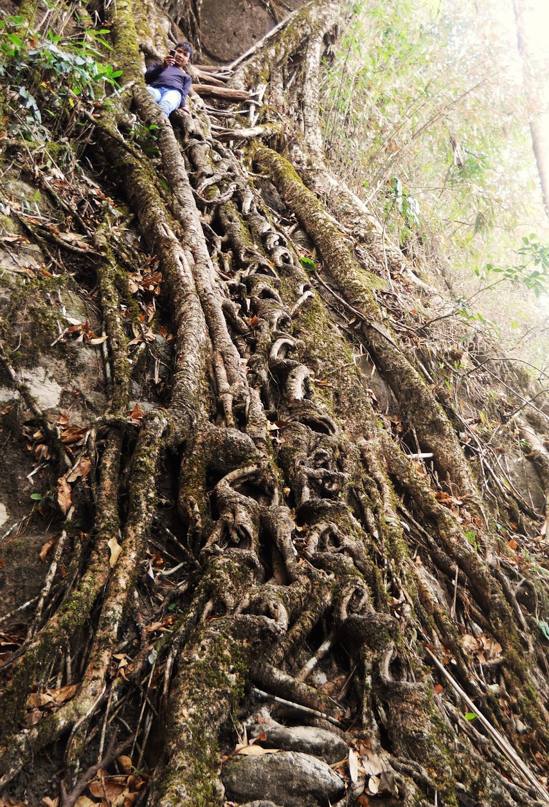
Heavy metal living root ladder near the mid-sized Khasi village of Pongtung
First off, for more information on living root architecture, go to The Undiscovered Living Root Bridges of Meghalaya Part 1: Bridges of the Umngot River Basin for living root bridges in the Jaintia Hills, The Undiscovered Living Root Bridges of Meghalaya Part 2: Bridges near Pynursla for information on the area with the highest concentration of living root architecture, and The Undiscovered Living Root Bridges of Meghalaya Part 3: Bridges of the 12 villages for some of the most remote known living root bridges.
This, the final post in my four part series on unknown or obscure living
root architecture, will deal with structures made from living roots
that are not bridges, along with failed or destroyed living root
bridges.
While the living root bridges are by far the most famous variety of
living root architecture in southern Meghalaya, similar techniques have
been used to create a surprising number of other functional structures.
Broadly speaking, these include living root ladders, platforms, and
retaining structures, along with hybrid constructions that are several
of these things at once.
Perhaps the least photogenic, though nonetheless extremely ingenious,
use for the living roots of Banyan trees is in the construction of
retaining structures. While walking on horizontal paths in the Khasi
Hills, which usually hug the sides of steep inclines, one often notices
that there will be Banyan trees directly next to the trails with roots
that seem to be almost holding the slopes up. That is indeed what is
happening, and, as I found out earlier this year, the trees have been
deliberately planted to perform this function. The roots of the tree are
being used to stabilize the slope, rockfalls and landslides being a
major problem in the hill country of Meghalaya. It's well known that
having lots of trees on a hill side can make it more stable due to the
gripping power of tree roots. Banyan trees, given their exceptionally
numerous roots which have evolved specifically to adhere to rocks and
steep inclines, are uniquely suited to this task.
While these structures (which may even stretch the definition of
architecture a tad) are less visually appealing and not as likely to
draw huge crowds of visitors as other forms of living root architecture,
they nonetheless continue to have great practical value. Particularly
at a time when the slopes of the Khasi and Jaintia Hills are under
increased pressure due to unsound farming techniques, the use of Banyan
tree roots as retaining walls could be potentially lifesaving. Projects
for stabilizing hill slopes through the use of conventional retaining
walls is not something that the people of remote Khasi villages would be
likely to be able to complete, as to do so effectively would require
large amounts of construction equipment, not to mention government
funds, which would probably entail outside construction crews. Using
Banyan trees much more extensively than they have been used already
would be both free (saplings would simply have to be transplanted) and,
in the long term, more effective. The roots used in the retaining
structures would only grow stronger and more numerous. The slopes would
get more stable over time.
However, it took me until about two thirds of the way through my long
hike in the Khasi Hills to even notice what these structures were.
Unlike other forms of living root architecture, they don't tend to stand
out very much, and don't look like much more than a tangle of roots in a
photograph. Still, when I return next year, I do intend to map as many
of them as I can.
Another .as yet very rarely visited, form of living root architecture
are living root platforms. I've only personally encountered two of
these, though I know of the existence of a third. They seem to be used
for observation, though more examples would need to be found to say
anything definite. For me, an interesting question is whether or not
platforms have been grown high up in trees (presumably for hunting).
This certainly would be possible, and might mean that I have walked
underneath numerous examples of these structures without noticing.
Finally, there are living root ladders. The use for these is pretty
obvious: When a trail needs to be built over terrain that is too steep
for stairs, the roots of Banyan trees are used to create a vertical
pathway. Confusingly, Khasi languages do not draw a distinction between
ladders and bridges, so the term "Jingkieng Jiri" (alternate spelling:
"Jingkieng Jri") is used for both kinds of architecture.
Interestingly, though I've not stumbled into as many living root ladders
as I have living root bridges, I have come across two very distinct
methods for modifying Banyan tree roots into structures one can climb up
and down. The first is simply to train roots horizontally so that they
form rungs. The second is to cut out rungs into large, already
established Banyan tree roots. The cuts will, over time, expand with the
growing root.
Again, as with living root platforms, not many living root ladders have
been found. There may be many more in southern Meghalaya but their
locations are as yet unknown.
PONGTUNG DOUBLE LIVING ROOT LADDER:
This is the most spectacular example of a living root ladder that I can
across during my month long hike in Meghalaya. It's near the medium
sized Khasi Village of Pongtung, about 20 minutes hiking to the east of
N.H. 40 (one way). After the initial turn off of N.H. 40, reaching it is
fairly straight forward, however you'd need to have a pretty
knowledgeable guide to recognize the turn to begin with. Basically, just
south of Pongtung, there is a concrete barrier on the eastern side of
the road, and the trail begins on the southern side of this. Still, for
now, getting a guide would be the best idea. I'm not sure whether or not
the ladder has seen other visitors. My guides to the bridge were from
Burma Village, and weren't really acquainted with the tourism scene.
The structure is exceptional because it consists of two distinct living
root ladders, one above the other, which employ two separate modes of
living root construction, though both ladders are formed from a single
tree. The path where the ladder was formed had to head down a cliff, so
the original planters decided to create the ladder where there were a
couple of tall natural steps in the cliff face. The ladder was sort of
draped over these steps. Unfortunately, this arrangement means that,
from the upper ladder, one can't see the lower, and vise versa, so
getting a really satisfying photo of the structure in its entirety
wasn't an option when I visited.
The shorter upper ladder uses a method whereby a number of roots were
trained horizontally in order to form a series of very closely set
rungs. On the lower ladder, it begins with the same method, though over
the majority of the structure steps were formed by directly modifying
the roots. It looks as though the makers of the ladder simply took a
machete and carved out a series of gashes in roots that had already
established themselves and the gashes then expanded along with the
roots, creating a series of steps.

Climbing the upper part of the Pongtung living root ladder
This is the lower part of the Pongtung living root ladder. Notice that
at the top, near the kid, are several rungs like those on the upper part
of the ladder. Those oval shaped holes in the sides of the roots are
the steps that have been formed with machetes

Looking straight down to the ground from the top of the lower part of the living root ladder
KONGTHONG LIVING ROOT LADDER:
This living root ladder is located right before the spectacular living root bridge I've named Kongthong 1 in the post The Undiscovered Living Root Bridges of Meghalaya Part 3: Bridges of the 12 Villages. Any hike from Kongthong to the living root bridge will mean climbing this ladder.

My friend Roy on his way up the Kongthong living root ladder

Roy ascending. Note the horizontal rung near the bottom of the picture

Looking down from the top of the Kongthong living root ladder
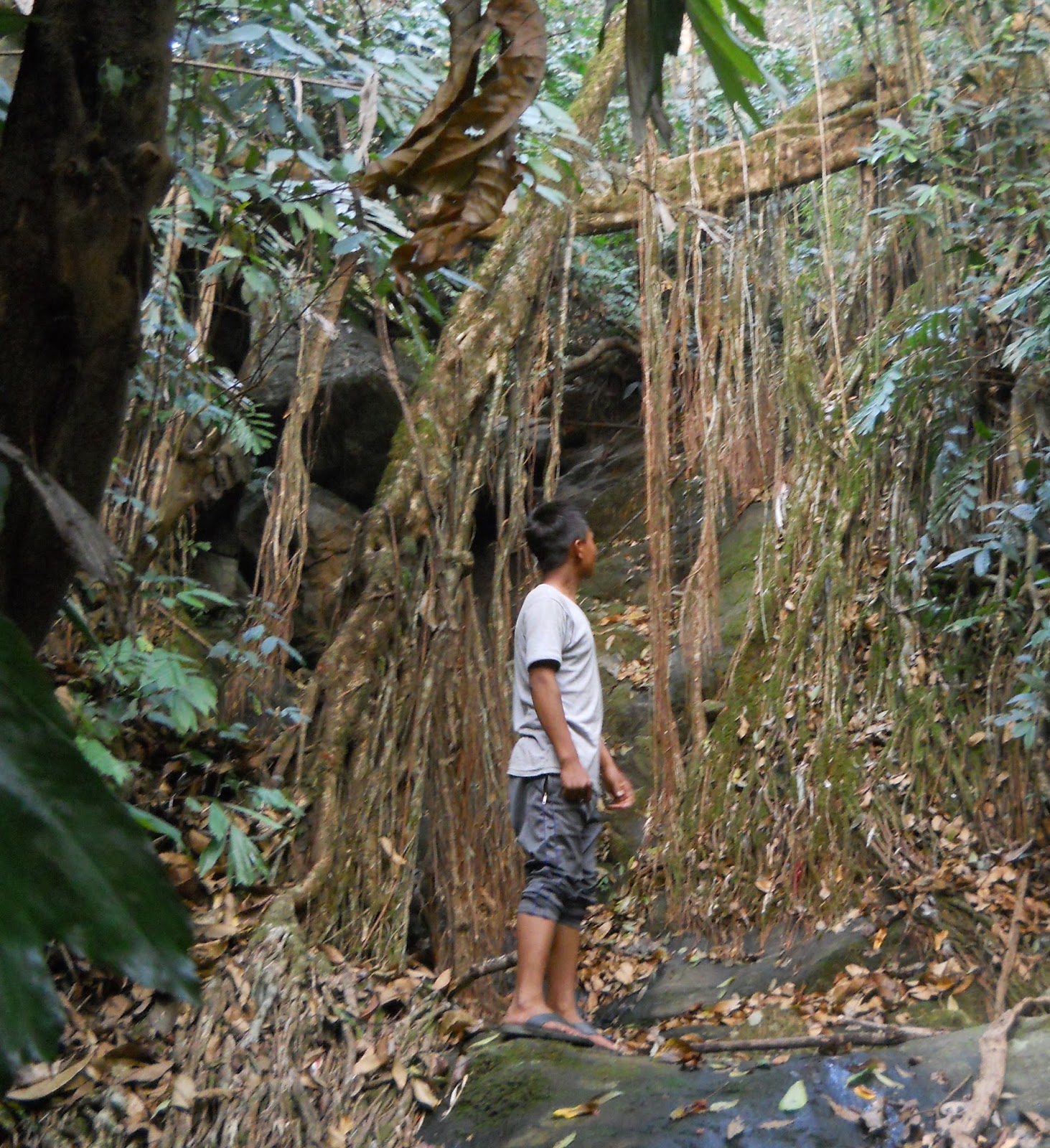
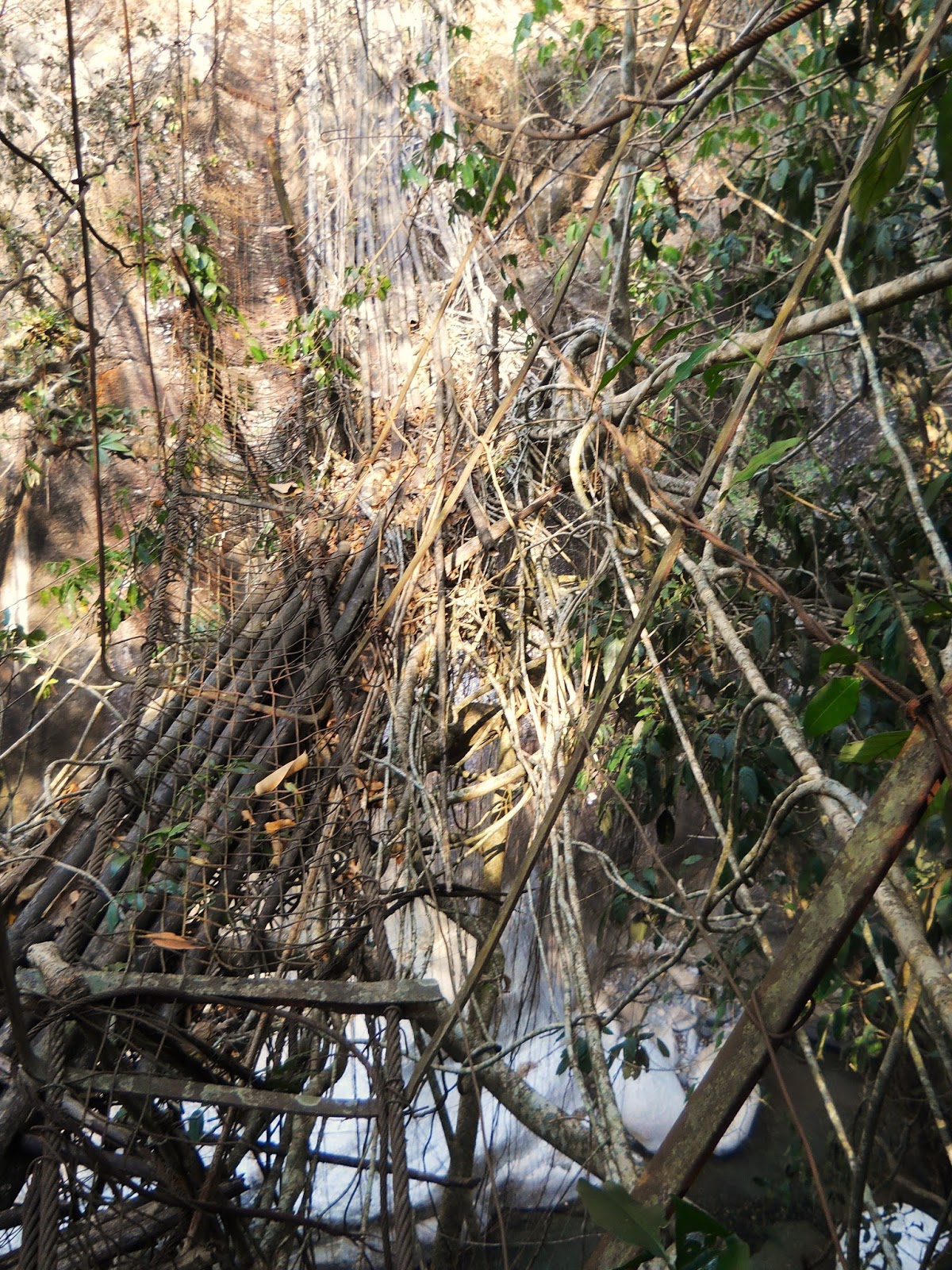
RANTHYLLIANG 8 (HYBRID BRIDGE/LADDER):
Note that more pictures of this bridge are included in the post The Undiscovered Living Root Bridges of Meghalaya Part 2: Bridges Near Pynursla
It come as no surprise that many living root structures simply don't fit
neatly into any particular category. For example, Rangthylliang 8 is
both a living root bridge and a living root ladder. You can see in the
photo below that the roots hanging down from the bridge have been used
to form several rungs of a ladder that provides access to the stream the
bridge crosses. A swing was also made out of the roots hanging down
from the bridge, so you could even say that Ranghtylliang 8 serves three
separate purposes at once!

Morningstarr climbing the living root ladder
KUDENG RIM LIVING BLEACHERS:
This was one of my favorite discoveries of my month long trek. In the
village of Kudeng Rim, next to their football field, a Banyan Tree has
been modified to serve as living root root bleachers. It seems to have
been altered specifically for the purpose of allowing the villagers to
watch football games from a lofty vantage point.
The tree has been altered in two ways. First, roots have been trained so
that, rather than hanging down onto the ground, they run closely around
the outside of the tree, which makes it easier to climb up into.
Secondly, several living root platforms have been created in the
branches of the tree by interweaving aerial roots.
This is an example of a piece of living root architecture where I really
am surprised that no one's ever posted anything about it online. Unlike
many of the obscure living root bridges, it's not at all hard to get
to, given that it's right next to Kudeng Rim. I would even go so far as
to say that, if you knew where it was, it would be vastly easier to
access than, for example, the world famous living root bridges of
Nongriat.
Yet, somehow, this fascinating structure has up until now remained entirely off the radar.

The Living Root Bleachers are in the tree directly behind the three kids in the center of the photo

Two people from Kudeng Rim in the Living Root Bleachers. Here one gets a
good look at the way the secondary roots have been trained to adhere
directly to the side of the tree. Without them it would be much harder
to climb up into it

Up on one of the platforms. While the roots of the platform are
relatively thin, the fact that there are so many of them makes it safe
to stand on

Another platform, facing a different direction
MYSTERY OBJECT NEAR RANGTHYLLIANG:

I'm not sure I know how to characterize this thing. It's primary purpose
might be to serve as a retaining structure. You can clearly see
something like a walkway made of roots near the bottom of the picture.
However, the archway, and the small but obviously trained root that you
can see running across it, are features that I've never seen in any
other living root structure. Unfortunately, I had to hurry past the
Mystery Object, so I could only get this one very insufficient
photograph
RANGTHYLLIANG REMNANT OR FAILED BRIDGE:
I spotted this from Rangthylliang 9, and later from downstream while
fording the river Rangthylliang 9 crosses. What it is is a very long,
straight, and, by the looks of it, trained, Banyan Tree root, suspended
high up above a river. However, with no railings of any kind it could
never be used as a bridge. I never actually took a photo specifically
of it....what you see here are pictures of other things, where this was
in the background, which I cropped to make this object as clear as
possible.
I was told at the time that this was just a random root. However,
looking at it again, I don't see how that could have happened. I think
there are two possible explanations for what this thing is. First: It
might be a remnant of a much larger living root bridge that got mostly
swept away. Second: It might be a bridge that failed to form properly
and was abandoned.

The unknown object is that black line near the bottom of this
photograph. It's hard to imagine that this root fell out like that
naturally

A highly zoomed in photo looking at the same object. Unfortunately, I
didn't have the time to see where the root began and ended. However, one
thing that can be said on the basis of this picture is that the root
has been there for a very long time, judging by its thickness
RANGTHYLLIANG DOUBTFUL BRIDGE:
As you might suspect, when it comes to living root architecture there
are some cases where its not entirely clear weather the structure in
question is natural or man made. The Doubtful Bridge of Rangthylliang is
such an example. More or less, it's just one big root across a ravine.
It is, however, a useful root, which a guy from Rangthylliang does use
to cross the ravine in the monsoon season, though with a bamboo pole
attached to provide a railing.
In fairness, I am told that said root was planted, though I've also seen
plenty of similar things that had formed naturally, so I'm just not
sure.
Morningstarr looking up at the Doubtful Bridge of Rangthylliang

Another look at the Doubtful Bridge of Rangthylliang
RYMMAI REMNANT BRIDGE:
This is a small section of a largely destroyed bridge near the village
of Rymmai. The original bridge would have been a double span structure,
with the two parts of bridge leading both to and from a small island in
the middle of a fairly wide stream. The longer part of the bridge,
which would have crossed the stream's main channel, is gone, though a
small part that crosses the narrower part of the stream survives.

The ex-headman of Mawshuit village standing on the remnant of the living root bridge at Rymmai
RUINED BRIDGE AT KUDENG RIM:
There are many places in the Khasi and Jaintia Hills where one can see
the sites of living root bridges that have been recently destroyed. This
is an example near the village of Kudeng Rim. The bridge was apparently
destroyed in a fire. One threat to the survival of living root
structures is the fact that the actual rubber in Banyan trees is highly
flammable. I was told that this particular bridge was destroyed a few
years back when someone failed to put out their bidi before throwing it
away as they crossed the bridge. Once a fire really gets going in the
roots of a Banyan Tree, particularly in the dry season, it's virtually
impossible to put out. The roots may as well be permeated with rubber
cement.

The site of the destroyed bridge near Kudeng Rim. You can see remnants
of the structure on either side of the stream. Also, note the root
hanging down from above, which looks as though it was once part of the
living root bridge
KHONGLAH REINCARNATE BRIDGE:
I'm using the term "Reincarnate Bridge" to denote instances where living
root bridges have been destroyed, and then other bridges (usually made
from bamboo) have been put up in exactly the same place. Frequently,
these are hybrid structures, where the remnants of the destroyed bridges
are incorporated into the new constructions.

The Khonglah Reincarnate Bridge. It's a steep bouldering expedition
downstream from the bridge I called Khonglah 6 in the first post in this
series. Here, you can see the tree that the former living root bridge
was made from
SHNONGPDEI REINCARNATE BRIDGE:
This is another example where a bamboo bridge has been built at the site
of a destroyed living root bridge. This is upstream from the bridge I
referred to as Shnongpdei 1.
The original living root bridge in this case was fairly close to the
water. Since flash floods in the area have gotten worse of late due to
changing agricultural practices, the builders of the new bridge have
deliberately raised the newly constructed bridge high off the stream.

Rothell Kongsit at the Shnongpdei Reincarnate

Another view on the Shnongpdei Reincarnate. At the time, it was
impossible to walk out on this bridge. The bamboo had not been changed,
and was partially rotted out...a problem one does not have with living
root architecture...
NONGPRIANG REINCARNATE:
At one time, this must have been a truly spectacular living root bridge.
In this case, a part of the original living root bridge survives, and
has been combined with the bamboo bridge. Secondary roots are growing
along the length of the newly built structure, and appear to be being
encouraged to do so. Perhaps, some time in the future, roots from either
side of the bridge will be linked together, and a new living root
bridge will be formed. Of course, what destroyed the bridge originally
will remain a factor, though were the area to become a tourist
attraction, the people of Nongpriang might decide to regrow and protect
the bridge for that reason.

The Nongpriang Reincarnate. The tree that the bridge is formed from is
huge, suggesting that there might have been a bridge here for a very
long time. The living root bridge might have gone through several
iterations before the one that was most recently destroyed

Here you can see the place where remnants of the destroyed living root
bridge and the newly built bridge meet. Note the way that chords of
young roots are being encouraged to grow out along the span. While this
may not be a full living root bridge again any time soon, the young
roots may well get worked into the existing framework to strengthen it.
This raises the question of how often living root bridges, rather than
being planted and begun as root bridges, are instead formed by growing
out roots on conventional structures. There is, for example, a hybrid
steel-wire structure near the village of Nongriat where such a method is
being employed to form a new living root bridge

Looking out along the span of the Nongpriang Reincarnate showing how far
along the bridge the young rubber tree roots have reached
So, that, finally, ends my posts on the living root architecture I
reached on my month long hike from Shnongpdeng to Cherrapunji earlier in
2015. While I discovered vastly more than I was expecting to, the truth
is the biggest discovery was that, as much as I found, such evidence as
there is points to there being vastly more living root architecture in
the region. There is so much more work to be done, and all I've put down
here was nothing more than a reconnaissance.
The Undiscovered Living Root Bridges of Meghalaya Part 3: Bridges of the 12 Villages

My friend Roy on a spectacular, never before visited living root bridge
near the village of Kongthong, in the heart of a region called the
Katarshnong, or 12 villages
First off, for more information on obscure living root bridges, go to: The Undiscovered Living Root Bridges of Meghalaya Part 1, covering the living root bridges of the Dawki region, and The Undiscovered Living Root Bridges of Meghalaya Part 2,
which covers the area with the highest (known) density of living root
architecture, the hills and valleys surrounding the small town of
Pynursla.
Before getting into this post I would just like to thank Rothell Kongsit
and all the folks in Kongthong village who showed me around the
Katarshnong. Needless to say, my reaching what you see below never would
have been possible without them!
So, moving right along...
THE TWELVE VILLAGES (Known locally as the "Katarshnong")
VILLAGES COVERED: KONGTHONG-SHNONGPDEI-MAWSHUIT-NONGSHKEN-SOHKYNDUH-NONGPRIANG
The name 12 Villages, or Katarshnong, refers to a rugged region of
slopes and valleys which is between two of the great ridges of the Khasi
Hills. Were one to draw a straight line from Pynursla to Sohra, it
would pass over the Katarshnong, and would be only, maybe, seven or
eight miles miles in length. But crossing the same area on foot, as I
found out earlier this year, is far less straightforward, and involves
going up and down endless ridges and valleys, through some of the most
isolated settlements in the region.
The area is not, as yet, famous for its living root architecture. As far
as I can tell most of the living root bridges in the region have not
been visited by outsiders, and even people in the area engaged in
promoting tourism have not regarded the Katarshnong's living root
bridges as an asset when it comes to attracting visitors (though that
might have changed somewhat after my visit).
As it is, what has attracted a (very tiny) trickle of visitors to the
area is a unique cultural practice called "Jingrwai Iawbei," where at
birth the children of certain villages are given a sort of musical name,
or theme, by their grandmothers. The people of this regions use this
musical nomenclature to communicate to each over long distances. For
example, if two people are working out in the their fields, separated
by, let's say, a valley, instead of calling out to each other by name,
they'll actually sing out each other's songs.
For good reason, it is this custom which the area is becoming known for (though it is still exceedingly remote), but the region also has a number of spectacular, and largely unvisited, living root structures. As for how many exist in the Katarshnong, it's hard to say. My travels merely took me on a fairly shallow reconnaissance of the region, rather than giving me the chance to do a proper survey. I do know that, at one time not too long ago, there were many more living root bridges in the Katarshnong. Unfortunately large numbers have succumbed of late to fires and landslides. Of all the areas I covered on my long hike, it seemed like it was this area where the living root structures were in the greatest danger. Vast swathes of the region's jungle are very rapidly being burnt down and replaced with a variety of grass used for making brooms, and this process is destroying most of the area's living root bridges. It's hard to imagine that there will be many left in a decade or so, unless tourism in Kongthong takes off fairly soon, and the people of the region realize just how much they have to gain from preserving their heritage (and what little remains of their jungle).
Of all the living root bridges on this page, the only one which seems to have been visited before I reached it is MAWSHUIT 1. Otherwise, the photos of the living root bridges you see here are the first ever to appear online.
KONGTHONG: 2 BRIDGES, OTHERS LIKELY
At the moment, Kongthong is the most tourist friendly village in the Katarshnong region. It even has overnight facilities in the form of the newly built "Kongthong Travelers Nest." It is probable that in the next few years Kongthong will become a village tourism destination to rival Nongriat, though its not quite there yet. It makes an excellent base for exploring the center of the Katarshnong, and also affords some of the best views I've seen in Meghalaya, where one can look out over a huge expanse of the surrounding hills and valleys, all the way out to Pynursla.
It also happens to be the most accessible place to experience "Jingrwai Iawbei." While there are several other villages where the phenomenon seems to occur, none of them have significant tourist facilities.
KONGTHONG 1:
This is one of the most distinctive of all living root bridges, and also one of my personal favorites. The way it's main span slopes upwards makes it look almost like a living root ladder, and in all my time in Meghalaya, I've not seen another living root bridge like it.
I was told that I was the first outsider to come to Kongthong 1. That being said, after making it all the way to Kongthong, reaching this bridge is not all that difficult: There is a very clear path that starts right next to the village, and heads almost straight down to the living root bridge, crossing an exceptionally long steel wire suspension bridge on the way. By the standards of the Khasi Hills, the path is almost gentle. However, when I first went my guide Roy took me up to the living root bridge through the bed of the river Umrew. This route takes one through spectacular canyon scenery, and is also highly recommended, though it's a longer and more strenuous hike/canyon scramble.
Before you reach Kongthong 1, there is a living root ladder, which I'll talk about in my last post in this series.

Roy stands mightily upon Kongthong 1. How the original tree wound up in
this strange configuration is hard to say. The natural center of the
tree seems as though it's being held up by deliberately trained living
root load bearing members that appear younger than the branches of the
tree above

This is the view of Kongthong 1 from upstream. It can also be viewed as a
dual span living root bridge; The first span is the ramp-like structure
you see here, while the second is a short, though clearly deliberately
trained, span which leads from the center of the tree back to the
opposite bank
KONGTHONG 2:
This is a small, apparently damaged, living root bridge, about 40 meters
upstream from Kongthong 1. An attempt is being made to grow new roots
onto it to make it functional again.

Kongthong 2
SHNONGPDEI: 1 BRIDGE
Not to be confused with Shnongpdeng, Shnongpdei is an exceedingly remote
village, about a ninety minute hike north of Kongthong. You're only
real chance of reaching it would be to contact the tourist society in
Kongthong and have them guide you.
The upper reaches of the river Umrew flow next to Shnongpdei, and the
one (known) living root bridge in the area is accessed by climbing down
from Shnongpdei into the river, and then scrambling some distance down
the watercourse to the living root bridge. There may be an easier way to
get to the bridge, though no matter what, reaching it would entail a
certain amount of scrambling.
Both from physical evidence and what I was told at the time, the river
next to Shnongpdei was once spanned by quite a few living root bridges,
though these have mostly been been destroyed in recent years due to
rising flood levels, again, a result of the conversion of the jungle
into broom grass fields. Several have, however, had a reincarnation of
sorts in the form of bamboo bridges (I'll also cover one of these in my
last post). The one living root bridge that has survived has only been
able to because it's partially protected from monsoonal floods by a big
boulder.
The protection offered by the boulder, however, didn't prevent the
bridge from being knocked down sometime in the past. Most of the bridge
was destroyed at one point, leaving only part of it standing on the
western bank. Then the bridge was then reconnected, I'm told, maybe 60
or 70 years ago (figures are fuzzy under such circumstances.)
The living root bridge was originally planted to service a village
which no longer exists, and the paths down to the structure seem to have
largely disappeared. The locals therefore didn't see any real reason to
maintain the bridge, and at the time I visited, parts of it had fallen
apart.
I was led down to the living root bridge by the head of Kongthong's
tourism society, Rothell Kongsit, a couple of other folks from
Kongthong, and also some people from Shnongpdei. It was Rothell's first
visit as well. When we arrived at the bridge, Rothell explained to
everybody that the bridge could be a major tourism asset, and that they
shouldn't let the structure be destroyed. All the locals then started on
the spot repairs on the living root bridge. Therefore, the living root
bridge I left behind was very different from the one I first
encountered. This marked the only time where I witnessed a living root
bridge actually being constructed.
I do hope the bridge survived this year's monsoon season. There is a
fairly good chance that, as I write this, the bridge has already
disappeared.

Shnongpdei 1, classic, simple, and spectacular. It is a fairly long
bridge (I would estimate that it is slightly longer than the longest
living root bridge in the Nongriat area). It looks much smaller from
upstream than it does from downstream, because the boulder in the
background obscures much of it. Rothell is second from left

The view across the span, from the eastern side of the living root
bridge, before any repairs had been done. You can see here that the
railings on the left side the picture are less intact than those on the
right

In the process of repairing the bridge, using the rubber tree roots
available. Notice the thin roots coming in from the right side of the
frame. This is a sort of a living root variation of a feature one sees
frequently on modern steel wire bridges. Once those roots strengthen,
they'll serve to keep the bridge from swaying too much in the wind and
in flood waters. I'm not sure if it'll work or not: The roots probably
won't have grown strong enough by the time the bridge is put to the test

More repairs being done. Note the number of roots that were hanging down
that have been incorporated into the structure. If they survive this
year, they'll add greatly to the stability of the living root bridge.
There always seems to be a certain amount of opportunism that goes into
creating and maintaining these structures

The newly repaired railing. These roots will take a couple of years to become useful

The whole team at work on Shnongpdei 1
MAWSHUIT: 1 BRIDGE, 3 OTHERS KNOWN TO EXIST BUT NOT VISITED
Mawshuit is a small village west of Kongthong. It has also seen a few
visitors. The village, and the root bridge listed here, would be
accessible in a day hike from Kongthong, though I stayed the night in
Mawshuit. There seem to be quite a few living root bridges in the near
vicinity, and I am told that there are many more in the surrounding
villages, though at the time I could only manage to visit one. Exploring
this region more thoroughly will be a high priority when I return.
MAWSHUIT 1:
This is a spectacular, though sadly dangerous and badly maintained,
living root bridge on the Muor River, northwest of Mawshuit. It is, to
my knowledge, the only living root bridge in this post which has been
visited, photographed, and had information about it published online. A
tour outfit called Vagabond Expeditions reached it sometime this year,
though their blog post about it is dated several months after I visited.
Also, a few trekking groups, including one apparently made up of
American college students, have stayed in Mawshuit and trekked to the
bridge. However, visitors are still extremely rare, and, if anything,
seem to have ceased entirely, at least of late.
The bridge itself, at least according to the Vagabond Expeditions
website, used to service a major trail that connected Mawshuit with the
nearby small town of Khrang, though the entire trail was mostly
abandoned around 1996 after an alternate route was constructed.
The bridge is clearly a very young one: So much so that the roots are
thin enough that in places you could slip right through them. The bridge
is also very high up above its stream. These two factors combine to
make the living root bridge one of the most dangerous I've ever
encountered. I learned this the hard way when I wandered right out onto
the middle of it and then realized I was centimeters from doom...I'm
afraid, unless you're tiny, going out on it is probably not a good
idea.
It is, however, in one of the most spectacular settings of any living
root bridge, as it spans a narrow, rocky, gorge. Were the people of
Mawshuit to put their minds to it, they could develop and maintain the
bridge. If the bridge itself were not in such poor condition, the view
of it from downstream could become one of Meghalaya's great post card
shots, and the village could do a steady business in bringing people to
see it (a guide, at least at this stage, would be a must).

The former headman of Mawshuit village, standing upon Mawshuit 1. He is,
of course, much smaller than I am, making the bridge much less of a
safety hazard for him. You'll notice that there's a steel wire bridge
right above it. I'm not sure which came first. Both are abandoned and
rather too dangerous to cross.
The tangled view of the bridge from the eastern end of it. This is what
you see first when you approach the bridge from Mawshuit. It really
isn't very picturesque from this vantage point. Here you get a good
impression of how thin the roots are

Closer to the center of the bridge

Zooming in on the span and the ex-headman
NONGSHKEN: 1 BRIDGE
Nongshken is a tiny village on the long route between Mawshuit and
Cherrapunji. If you were to walk from Cherrapunji to Kongthong, you
might come this way. I have absolutely no information on other living
root bridges in the area.
NONGSHKEN 1:
This is a pretty, classic, medium length living root bridge in a small
wooded valley below Nongshken. It lies directly on the fairly important
route linking the villages of Rymmai, Nongshken, and Sohkynduh.

Nongshken 1

The view from upstream....

....and from downstream. The man in the photo was my guide from the village of Rymmai
SOHKYNDUH: 1 BRIDGE
Sohkynduh is a village within sight of Cherrapunji, and would be
accessible from Cherrapunji itself in about a five hour (at a moderate
pace) trek. The village does not have any tourist facilities, and is at
this point very unused to outsiders. However, if it did have a home
stay, it would make a very good base to begin exploring the Katarshnong
from.
I only spent one night there, though that was just long enough to see
that the village is the terminus of a network of trails that lead into
the southern part of the Katarshnong, a region in which I have never set
foot, though which almost certainly has a significant number of
examples of living root architecture.
SOHKYNDUH 1:
This is a small but very interesting, and clearly very ancient, living
root bridge a steep two and a half hour hike (both ways) from Sohkynduh.
It has a very distinctive, triangular, profile, as the planters decided
to use what would become some of the tree's main branches in the
structure of the living root bridge.

Sohkynduh 1

My guide from Sohkynduh on the living root bridge

A local villager crossing Sohkynduh 1. Note how thick the root next to
him is. Allowing for the fact that the man is probably very short, the
root must still be in the vicinity of two and half to three feet thick,
meaning the bridge must be hundreds of years old
NONGPRIANG: 1 BRIDGE, SEVERAL DESTROYED BRIDGES
Walking from Kongthong, Nongpriang is the last village one goes through
before reaching Cherrapunji. It lies directly at the bottom of the steep
slope to the east of Cherrapunji, I'd say about an hour's walk
downhill, or a three hour's walk up.
It still manages to be a pretty little village, though the surroundings
are sad: As I walked through, the jungle in the area was literally in
the process of being burnt down. It's clear that, not too long ago,
there were a great many living root bridge around this village. While I
saw one functional one, I also saw two other places where living root
bridges had been, though they were destroyed recently. I didn't have the
time to do a proper survey of the area, so it's more than possible that
there are other, still functional, living root bridges accessible from
Nongpriang.
NONGPRIANG 1:
This is a small bridge on the path between Sohkynduh and Nongpriang.
It's very near some large patches of jungle that were cleared in
shifting cultivation fires recently. It looked to me at the time that
the bridge itself had only narrowly missed being consumed in the fire.
It also happens to be the last living root bridge I discovered on my
month long trek. A few hours after the photos below were taken, I was
back in Cherrapunji.

My guide on Nongpriang 1

Nongpriang 1

The view of Nongpriang 1 from upstream
Coming soon, the final entry in this series: The Undiscovered Living
Root Bridges of Meghalaya Part 4: Living Root Ladders and other uses for
Living Root Architecture
The Undiscovered Living Root Bridges of Meghalaya Part 2: Bridges Near Pynursla

Jungle Man John Cena and friend cling to roots with the longest known living root bridge in the background
First, for more info on obscure living root bridges, go to: The Undiscovered Living Root Bridges of Meghalaya Part 1: Bridges of the Umngot River basin
Before I get into the post, I'd just like to thank my friend Alan West,
who pointed me in the general direction of the area in this post, and
also my redoubtable jungle guides: Morningstarr, John Cena (A.K.A.
Jungle Man John Cena), and Morningstarr's dad. Without them, I might
very well have seen just a few of the bridges in the area, and then
moved on. These three know their area incredibly well, and were able to
show me places I otherwise would have surely missed. They know that what
they have in their area is something truly of value.
So, moving right along:
PYNURSLA
VILLAGES COVERED: RANGTHYLLIANG / MAWKYRNOT-MYNDRING
Once I had reached the medium sized Khasi town of Pynursla, I had
already vastly exceeded the number of living root bridges that I thought
I could expect to find on my long trek. My assumption was that the
trip's greatest discoveries were probably all behind me. But then
Pynursla blew that notion away. Within a few kilometers of that totally
unassuming, entirely untouristed town, is the highest density of living
root architecture known to exist. In comparison, the living root bridges
around Cherrapunji seem rather thinly spaced out. Even around the
village of Nongriat, at the moment the center of root bridge tourism,
there are only (by my calculations) nine living root structures,
including two rather beyond the tourist zone. In the Pynursla area, I
came across as many on a single hike. Here, I'm listing nineteen structures. There are many more in the area.
Just a warning: The photos below are of very variable quality.
Conditions were often just too rough to have the time to take lots of
really good photos. All nineteen bridges were visited over the course of
only four hikes, and these were all immensely difficult endeavors. My
guides had such a knowledge of the land that they simply did not need
trails. Rather than walking, they often preferred to climb, up and down
unstable slopes, precariously clinging to roots and bushes, me following
as best I could. And, for some of the living root bridges, this was the
best way to reach them. Many living root bridges do not have clear
paths to them (or paths leading to them at all). Those that have
survived yet outlived their usefulness are lost out in the jungle,
forgotten, but still growing stronger.
The incredible density of living root structures in this area should not
lead to the assumption that there is no place in Meghalaya that has
more of them. The only thing that the number of living root bridges
around Pynursla suggests to me is that, in all likelihood, there are
places with just as high, or even higher, concentrations of living root
architecture, that are simply further from civilization and therefore
will take longer to become known (if the bridges aren't destroyed in the
meantime, which is likely).
RANGTHYLLIANG / MAWKYRNOT: 16 BRIDGES (MANY MORE UNVISITED)
At the moment, the village with the most known living root bridges is a
small settlement, almost a kind of suburb, of the town of Pynursla
(though it in fact predates the town), called Rangthylliang. The village
is on the edge of a vast canyon system, and it's land slopes down into
the gorge via a huge, steep, jungle covered ridge. An astonishing number
of living root structures occur on this promontory, a handful of which
are already starting to be famous, though the vast majority are unknown.
While I can reasonably safely say that I was the first foreigner to
reach most of these bridges, several very local Khasi tourism societies
do operate in the area, though so far they seem to have had little luck
promoting the area. Maybe this post will help in a small way.
There are a few bridges that have been "discovered" as it were. These
are what I'm listing as Rangthylliang 1-5. Several of these are among
the most extraordinary known living root bridges, including the world's
longest example, and also an (unfortunately damaged) "Triple Decker."
There is, sadly, something of a political dispute over the world's
longest bridge: It actually crosses over the stream that marks the
border between Rangthylliang's land and that of a village called
Mawkyrnot. The bridge appears to have been planted on the Rangthylliang
side of the border, but it's easier to access from Mawkyrnot. The only
tourism that the area is seeing at the moment is a little bit coming
from the world famous village of Mawlynnong, and a few guides from that
village take tourists to the longest bridge via Mawkynot. The bridge
seems to be claimed by that village, which is something that's not going
to sit too well in Rangthylliang once the area starts getting famous
and tourist rupees start pouring in...I was told that, back in the hazy
past, the two villages fought wars over that particular piece of
real-estate, so I hope that doesn't start up again.
I'm listing the first five bridge under Rangthylliang, though be advised
that more people in Meghalaya (though not many!) are going to have
heard of Mawkyrnot as the village to approach these bridges from. After
1-5, the rest of the bridges mostly seem not to have been photographed
or visited by outsiders....not that anything on this list has seen more
than a handful of visitors at this point...
RANGTHYLLIANG 1:
This is, in terms of a single span, the longest known bridge (there is
another bridge, later in this post, which might be longer in terms of
its full structural length, through it's divided into two spans). This
is also the most famous bridge on this list, having appeared in a photo
in The Atlantic. The photographer had visited Mawlynnong, and was
brought here. Still, visitors are exceedingly few, though that's likely
to change very soon.

The classic shot of Rangthylliang 1, undoubtedly one of the most
spectacular examples of living root architecture. At over 50 meters,
it's much longer than the longest (known) living root bridge in the
Cherrapunji area. It's also over 30 meters above its stream. The claim
has been made that it is a newly planted bridge, since it does not have
functioning rails composed of living roots. I find this doubtful: The
main root of the structure is very thick, while the tree, which you can
see on the right of this picture, certainly looks like it was modified a
very long time ago. Also, some of the secondary roots coming down from
the main root look to be as thick as small trees. It seems either that
the rails were destroyed at some point, or that the bridge has always
had the current, hybrid, arrangement, where bamboo is used to provide
the actual walkway and hand-railings

Looking up at Rangthylliang 1 from below. Note the way that the tree the
living root bridge is formed of seems to lean out over the precipice.
This would seem to indicate that the tree has been there a very long
time, and that the ground beneath it has been undercut. That also leads
me to believe that Rangthylliang 1 is an older bridge
RANGTHYLLIANG 2:
Rangthylliang 1, 2, and 3, are all within sight of each other.
Rangthylliang 1 and 3 cross the small stream that separates the land of
Rangthylliang and Mawkyrnot. Rangthylliang 2 spans a small brook that
comes down a rocky cliff face and then feeds into the larger stream,
between the other two bridges. It's a very pretty bridge in its own
right, though not an especially photogenic one.

Rangthylliang 2, viewed from a distance

Crossing Rangthylliang 2
RANGTHYLLIANG 3:
This is quite a large, "classic," living root bridge, perhaps 150 meters upstream from Rangthylliang 1.

Jungle Man John Cena swinging on a root, under Rangthylliang 3

Rangthylliang 3
RANGTHYLLIANG 4:
This is a very small bridge between the three pictured above and the
next entry. As I had to keep up with my guides, I only manged to take
one photo, which was out of focus, and wouldn't look like anything if I
posted it here. I would estimate it's about eight feet long.
RANGTHYLLIANG 5 (RANGTHYLLIANG TRIPLE DECKER):
This extraordinary bridge is about a twenty minute (at a reasonable
pace) walk from Rangthylliang 1. When I first visited, I had thought
that it was a "Double Decker," with a similar arrangement to the world
famous Double Decker living root bridge in Nongriat. While perhaps not
quite so perfect as the more famous structure, the Rangthylliang bridge
struck me at the time as rather more spectacular, simply because the
upper span was longer, and also higher above its stream, than the
Nongriat Bridge.
Sadly, the bridge has been damaged very recently. A tree has fallen over
onto the lower span, and if you weren't paying close attention, you
might not even realize that the bridge was a multiple span structure.
That being said, the span that was hit does not seem to have been badly
damaged, it's just partially hidden under a big tree. If there was
somebody in the area who was sufficiently motivated (and there does not
seem to be at the moment), they could probably repair the living root
bridge.
However, just in the last couple of days, as I was scouring the internet
to see if there was any other information on the bridges in this area, I
found something that makes this bridge even more exceptional. It may be
the world's only known example of a "Trip Decker" living root bridge. A
very local Khasi hiking club put up a photo of the living root bridge
from two years ago on their Facebook page. This was before the tree
fell, and what the photo shows is actually three spans.
At the time I visited, I didn't see a third span. It might have been
destroyed, or it might have been hidden by the fallen tree. Also, there
is the possibility that the third span is actually an entirely separate
living root bridge, grown from another tree. Still, whether it is a
double or triple decker structure, Rangthylliang 5 illustrates that the
diversity of living root bridges, and of living root architecture in
general, is vastly greater than than the world assumes.

My guides on Rangthylliang 5. You can see here that the upper span is a
great distance above its stream. The lower span is under that tree

Jungle Man John Cena on the uppermost span

Here you can get a fairly good impression of the arrangement of the two
upper spans. It's a fairly similar to layout of the world famous double
decker living root bridge in Nongriat

Investigating the lower (or middle?) span

Jungle Man John Cena on the upper span
RANGTHYLLIANG 6:
This small, simple bridge is beyond Rangthylliang 5. I've never seen another photo of it online.

Jungle Man John Cena on Rangthylliang 6
RANGTHYLLIANG 7:
This living root bridge is interesting simply because it's very newly
planted. It's two or three years old at most, and probably has at least a
decade to go before it becomes operational.
It's important for two reasons: First, it demonstrates that the actual
practice of creating living root bridges is still alive (though clearly
becoming rarer) in the Rangthylliang area. Second, it is the only newly
planted bridge that I've ever encountered outside of a tourist zone. I'm
reasonably sure no other outsider has seen it.

The roots of Rangthylliang 7 are very thin. I suspect that a large
number of living root bridges actually don't make it past this stage and
are destroyed in landslides, fires, and floods
RANGTHYLLIANG 8:
This is another truly remarkable living root structure, though, funnily
enough, when I visited it didn't even occur to me how unusual it was.
Here, a single tree has been ingeniously modified into both a bridge and a ladder.

The main bridge, which would be an impressive example of living root architecture all by itself. Note the root swing.

My friend Morningstarr climbing the living root ladder, which was made
by training the secondary roots hanging down from the bridge into rungs

Jungle Man John Cena swinging again....he never misses a chance...
RANGTHYLLIANG 9:
This is yet another extraordinary living root bridge.
Two things set it apart. The first is that, as I remember it, this
bridge is higher up off its stream than any I've come across. If memory
serves, the stream was something like 100 meters below. Needless to say,
a fatal drop. The living root bridge crosses a deep canyon.
Unfortunately, at least as far as photography is concerned, it's right
in front of a waterfall (dry at the time I visited) and therefore its
almost impossible to capture its great height in a photograph (in the
time I had...we moved on pretty quickly). A picture looking straight
down from the bridge doesn't look like anything.
The second thing that sets it apart is that the bridge is another double
span structure, but in this case, it's two spans are at a ninety degree
angle to one another, an arrangement which I've never seen
elsewhere....this is one I'm really looking forward to getting back to
and taking more pictures of...

Jungle Man John Cena on Rangthylliang 9. Note the very straight object
near the bottom of the photo. My theory is that this is a failed or
abandoned root bridge. I'll talk about it in the last post is this
series.
RANGTHYLLIANG 10:
This was a bridge that my companions and I crossed over very quickly,
right before we started a near vertical, thirty minute downward climb.
Below is the only picture of the bridge that I managed to take. The
bridge is clearly very old, and has been damaged in several places.

Morningstarr on Rangthylliang 10
RANGTHYLLIANG 11:
This is a spectacular, classic, living root bridge. A second root has
been trained across the river right next to it, creating something like
another "Double Decker," though the other root does not constitute a
separate, functional span.
I wasn't able to establish what the purpose of the second root was.
Currently, there does not appear to be any effort being made to use the
second root to form a new span. What it might be is a remnant of an
older span that has been almost totally destroyed in floods, except for
that one root...or it might just be a mistake...

Looking up at Rangthylliang 11

Closer on the main span and the mysterious second root

My companions on the main span of Rangthylliang 11
RANGTHYLLIANG 12:
This is one of a pair of two small, though very old, living root
bridges, well off any major trails. Living root bridges such as these,
which must be very numerous across Meghalaya, would be absolutely
impossible to find without guides who had an extremely intimate
knowledge of the local landscape.

Rangthylliang 12....yes, the photo doesn't look like much, though this is the best one I managed to take
RANGTHYLLIANG 13:
Judging by the secondary roots growing out of the bottom of this living
root bridge, it must be very ancient...perhaps the oldest I reached in
the Rangthylliang area. As I remember, it was no longer in use.

Morningstarr grins like a madman on Rangthylliang 13

Jungle Man John Cena finding another opportunity to swing on roots, in front of Rangthylliang 13
RANGTHYLLIANG 14:
Rangthylliang 14 and 15 are another pair of small but interesting living
root bridges. Again, without really good guides, I never would have
even suspected they were there. They were accessed by climbing up a
stream bed, the paths they once serviced having long since faded away.

Rangthylliang 14 in the foreground, with 15 in the background. Why the
original planters put the two living root bridges so close together is
an interesting (though probably unanswerable) question
RANGTHLLIANG 15:
This is a short distance upstream from Rangthylliang 14.

Looking up at Rangthylliang 15
RANGTHYLLIANG 16:
This living root bridge is a steep, three hour (one way) downhill hike
from Rangthylliang, near the border of Rangthylliang's land with that of
another village called Myndring. The living root bridge itself is a
very satisfying example of living root architecture, while the setting
of the bridge is one of the most beautiful places I've visited in
Meghalaya. The bridge crosses a small, clear stream right in front of
where it issues from a narrow gorge, poring over a very pretty little
waterfall. There is a nice, swimmable, pool in front of the waterfall,
and if you climb up the falls, there is another, even nicer, swimmable
pool at the top, with yet another small waterfall at the end of that pool.
It's a great place to spend a few hours, though since it's quite some
distance from Rangthylliang or Mawkyrnot, and since those villages don't
have any real overnight facilities as yet, this particular spot will
probably not be overrun by tourists for quite some time.

Rangthylliang 16

The stream in front of Rangthylliang 16. A wonderful place for a rest
MYNDRING: 3 BRIDGES (MORE LIKELY)
Myndring is a small Khasi village on a ridge downhill from Pynursla.
While not very far from the town as the crow flies, it is still very
remote, being only accessible on foot via a steep stairway. My
companions and I approached it from rather an odd direction: We started
in Rangthylliang, then climbed down into the valley between
Rangthyllliang and Myndring, and then climbed up into Myndring from the
jungle. I was told in Myndring that I was the first tourist to visit
within living memory, so the living root bridges pictured below had
probably not been seen by an outsider before.
MYNDRING 1:
Myndring 1 is a huge living root bridge that crosses the river that
marks the boundary between Rangthylliang's land and that of Myndring.
The main tree that the bridge is grown out of is on the Myndring side of
the border, so I'm listing it under that village.
I view this living root bridge as the most important single discovery of my month long trek. This is for several reasons:
The first is that it appears to be a very old bridge, yet it is also
over a large river. What this means is that it is an ancient bridge that
has nonetheless withstood the test of time. It might be 300 years old,
and yet has taken 300 years of abuse from 300 Meghalaya monsoon seasons.
While a few living root bridges still exist on larger streams, they
seem to usually be well up off the water, safe from floods. They are
also, as is the case with the longest bridge near Nongriat, or the Great
Bridge of Kudeng Rim, relatively new living root bridges. This
particular example is, very clearly judging by the root thickness,
ancient, yet it is fairly close to its stream, and is probably bombarded
yearly not just by flood waters, but also with the rocks and brushwood
the floods take down the stream with them.
The second reason it's remarkable is that it is another double span
structure, in this case with one span before the other. Unfortunately,
I couldn't get a picture of the second span (something I hope to do
properly when I return), but what you see in the photo below is only 60%
or so of the complete structure.
The third reason why I view this particular living root bridge as so
exceptional is that, by certain measurements, it might actually be the
longest known example. Rangthylliang 1 certainly is the longest in
terms of a single span, however the bridge below may be the longest in
terms of the distance over which a single organism has been modified.
I'm reasonably sure (though, again, I'll need to revisit!) that both
spans of the bridge put together would be longer than Rangthylliang 1 in
its entirety.
Sadly, as I crossed this bridge I saw that some of the roots were dying
of some sort of disease. It is more than likely that the living root
bridge will be swept away in the next few years, particularly if there's
increased slash and burn agriculture upstream. There isn't any
especially pressing practical reason for the locals to maintain the
bridge: While it once serviced a major trail between Rangthylliang and
Myndring, that path seems to have fallen largely into disuse over a
century ago. As far a tourism is concerned, even if there were
facilities in Pynursla or even in Rangthylliang, it's unlikely that your
average hiker would make it this far. I'm really not sure if this
bridge will be there the next time I visit, meaning that there is a
chance that the photos you see below might be the only ones that are
ever taken of this living root bridge.

Jungle John Cena and Morningstarr's dad stand mightily upon Myndring 1,
giving some scale. The living root bridge continues for some distance
beyond both ends of this photo. Note the size of the secondary roots
hanging down from the bridge, indicating an ancient structure

Another view on Myndring 1. Note the way that the secondary roots have
been bent back, presumably by year after year of monsoon floods. They
must look like that permanently, as there hadn't been a significant
rainfall in the area for several months when this photo was taken
MYNDRING 2:
This is a small but very interesting bridge, deep in the jungle on the
south side of the ridge Myndring is on. My companions from Rangthylliang
were just as surprised to run into it as I was, Myndring being well
outside of their usual stomping grounds.

Myndring 2

Morningstarr's father on Myndring 2. I was told that sign said, if
effect, that the village council had forbade local villagers from taking
hacks at the bridge with machetes. Once again, you can see here that
the roots on the bridge look to be well over two feet thick, making it
yet another very ancient structure
MYNDRING 3:
This exceedingly remote bridge, belonging to a local family in Myndring,
is in my estimation one of the most beautiful in the Pynursla area. At a
mere 40 years old it is, by the standards of living root bridges, quite
recent (though that figure was obtained from an old drunk and is
probably at best a fuzzy guess). I could only reach it by paying off the
family who owned it, something I would have of course been happy to do
had I not known the money was going to immediately go to alcohol.

Morningstarr on Myndring 3. Notice the two roots that sort of reach down
onto the bridge like support cables. I've never seen this arrangement
anywhere else. It does not seem to have made much difference: One of
those roots is actually connected to the bridge and is holding up some
of the weight, but the other is just hanging there. Still, they give the
bridge a very distinctive profile.

A view of the living root bridge from a distance. It's 20 to 30 meters
up off the ground in the middle of the span, the land behind it dropping
off very precipitously

The only picture you'll see of me on this list, along with Jungle Man
John Cena doing moves from the film "Ong Bak" (which happens to be his
favorite movie). Note how relatively thin the roots of the tree can be
and yet still be fully functional

The view across the span of Myndring 3
Coming soon: The Undiscovered Living Root Bridges of Meghalaya Part 3: Bridges of the Twelve Villages
The Undiscovered Living Root Bridges of Meghalaya
Part 4: Living Root Ladders, and other uses for Living Root
architecture.
The Undiscovered Living Root Bridges of Meghalaya Part 1: Bridges of The Umngot River Basin

The Great Bridge of Kudeng Rim...photos don't do it justice.
This is the first of four posts on the living root architecture of Meghalaya. The other three are coming soon!
For more living root bridges, go to: The Undiscovered Living Root Bridges of Meghalaya Part 2: Bridges near Pynursla and The Undiscovered Living Root Bridges of Meghalaya Part 3: Bridges of the Twelve Villages For other varieties of living root architecture, go to: The Undiscovered Living Root Bridges of Meghalaya Part 4: Other uses for Living Root Architecture
In February of 2015, I set off alone into some of the most remote parts
of the state of Meghalaya. My aim was to locate previously undiscovered,
or little known, examples of living root architecture. In this, I was
vastly more successful than I ever could have hoped. As I figure it,
over the course of a one month long hike from the village of Shnongpdeng
to the town of Sohra, I reached over fifty examples of living root
structures. While by far the most numerous of these were living root
bridges, I also managed to locate a number of other varieties of living
architecture, including living root ladders, observation platforms,
retaining walls, and also a number of structures which served several of
these purposes at once.
The more I've been around the living root bridges of Meghalaya, the more
unique they've struck me. I think it is not an exaggeration to say that
they are among the world's most unusual man made structures. There is
simply no other form of functional architecture where the structure
itself is alive. Nothing else built by man is more sturdy after 600
years than after 60. While there are examples elsewhere where a single
person (more often than not a widowed eccentric) has built a massive
edifice all by himself, with the living root bridges, this kind of
lonely endeavor is the norm rather than the exception. A single person
may begin a living root bridge by training a few thin roots across a
stream, and those same roots may develop into a monumental structure,
still in use centuries later. The original planter may have died half a
millennium before, he and his clan might be long forgotten, but his work
will, literally, live on.
While a living root bridge may serve a village for generations, to build
one, there is no initial investment, other than time. No workers need
be paid, no costly maintenance need be performed. The Taj Mahal is
impressive because it combines the exquisite architectural sensibilities
of the greater Mughals with their astronomical spending habits. It is a
monument, in part, to the opulence of a bygone age. But the living root
bridges were free to create, and served to address a very pressing
problem that confronts the people of southern Meghalaya even to this
day: That of crossing flood swollen mountain streams in the middle of
the world's most intense monsoon seasons. The living root bridges of
Meghalaya are therefore monuments to human ingenuity and common sense.
Given how totally unique this practice of creating living architecture
is, I began my trek under the mistaken impression that a certain set of
concrete facts must surely have been established about it. I left having
learned that virtually nothing solid was known about the custom. My
month long trek raised far more questions than it provided answers.
The truth of the matter is, to my knowledge, no attempt has ever been
made to study the practice of creating living architecture as a whole.
No attempt has been made to create a survey of the phenomenon. No
scientific paper has been written on them. At this point in time, not
only does no one have any idea of the true number of living root bridges
in existence: There is currently not even enough data to make an
educated guess. There may be tens, there may be hundreds, there may be
thousands. I had been told before my trek that there were about forty in
the world. I found closer to fifty on my walk, not including the two
dozen or so that I had already known to exist elsewhere. There is no
clear notion of the geographic extent of the practice. While the
southern border of it may reasonably be assumed to be the plains of
Bangladesh (though even this may prove incorrect), how far north, east,
or west it extends is unknown.
The area of the highest concentration of living root bridges is
similarly unknown: While the root bridges around the town of Cherrapunji
are what first brought the practice to the world's attention, from what
I have seen, the town of Pynursla has vastly more within just three or
four kilometers. Yet there may well be places with a higher density of
living architecture even than Pynursla. Without an in-depth survey,
there simply isn't enough information to say.
By the same token, the configurations that the various kinds of living
root architecture can be worked into is much more diverse than
previously thought. While the world famous Double Decker living root
bridge of Nongriat village is, undoubtedly, one of the most perfect
examples of a living root structure, the notion that it is unique in the
world for having two spans is simply incorrect: In the course of my
trek, around ten percent of the bridges I located had double spans.
Likewise, one of the bridges near the village of Nongriat is widely
regarded as the world's longest, simply because it's the longest in that
particular area, but during the course of my hike I came across several
which were significantly longer.
There is, however, one disturbing thing about the phenomenon that I did
establish: That many of the bridges have been destroyed recently, while
many others are well on their way to going out of existence. The
practice is fading. That the bridges grow stronger over time does not
necessarily guarantee their survival. The primary culprit for the
destruction of most of the older bridges is changes in the land use
patters of many of the villages in the region. Large swathes of jungle
are being cleared to make way for a type of grass used to make brooms.
As the jungle disappears, the slopes it once occupied becomes less
capable of retaining water, due to the fact that the root systems of the
grasses are much shallower than those of the jungle vegetation. This
results in landslides and stronger flash-floods than the area has ever
seen before. Sadly, these have taken most of the truly huge living root
bridges away with them.
Currently, if one types in the terms "Living Root Bridge" into Google
Images, about 90% of the images you'll get will be of only two of the
living root bridges: The Double Decker in Nongriat, and the large,
famous root bridge near Mawlynnong. After some searching, you'll find a
few more pictures of other bridges, but, on the whole, the information
on the internet is misleading: It leads one to believe that there are
far fewer living root structures in the world than actually exist. In
deep jungle villages, there may be any number of spectacular living root
bridge, totally unknown, but also under threat, from landslides, from
floods, from arson, from neglect, and from village councils that would
like to cut them down and replace them with modern, steel wire
suspension bridges.
Another thing I learned on my trek is this: Many villages, even ones
with large numbers of beautiful living root bridges, are simply unaware
that what they have is in any way unique, or something they could
benefit from. I was routinely asked if there are living root bridges in
the U.S. Since so many villages have never had visitors come to them in
order to see their living root bridges, the people of those villages
have never been given any sort of incentive to preserve what they have.
The only thing, to my mind, that can reverse this trend is to promote
the living root bridges, and other living architecture, in these remote
settlements.
I had begun my trek thinking I would find, at most, a handful of these
obscure living structures. The sheer number that I located took me
rather off guard: I wish, among other things, that my notes had more
thorough and that I had asked more questions. A trek which began as
something I was simply doing for fun mutated into a kind of (very)
amateur scientific expedition, and one that I was not prepared for.
My plan for next year is to start an online database, probably on a
separate Wordpress blog, listing as many living root structures as I can
find, along with a certain amount of data on them, including their
length, their height above their stream, the name of the stream they
occur on, which village owns the land they are on, GPS coordinates, and
any historical data about the bridges I can dig up. Doing this properly,
I'm sorry to say, depends on me being able to raise a certain amount of
money through crowdfunding, though I hope that there will be enough
interest in this phenomenon that I can at least reach my minimum goal.
These next couple of blog posts will be a sort of preview for the
project I'm starting. Next year, I'm going to have to go back to each of
the places listed below and take proper measurements, along with
surveying new areas. However, one thing I'm sure of is this: There is
far more to discover in Meghalaya. For all that I found during my
reconnaissance this Feb, I've barely scratched the surface.
Here, I'm including a few pictures, and some very basic information,
about the root bridges I came across on my trek. Not all of these photos
are of the highest quality, as I was often exhausted and in a hurry.
Very often, I did not have the luxury of waiting for nice lighting. This
might seem like overkill, but remember that a good number of the
structures listed below have never been photographed before.
THE UMNGOT RIVER BASIN
VILLAGES COVERED: NONGBAREH-KHONGLAH-PADU-KUDENG RIM-BURMA
The Umngot River flows next to the India/Bangladesh border town of
Dawki. Upstream from Dawki, it cuts a vast and rugged system of canyons,
which even now seem to be, at least partially, unexplored by outsiders.
The first expedition to successfully run the was river only a few
years back, and this only traveled along the main channel. We can assume
that many of the side canyons have received very few visitors.
The Umngot is the boundary between the East Khasi and West Jaintia
Hills districts. Culturally, the canyon it cuts is a transitional zone
where the closely related Khasi and Jaintia groups meet and merge into
one another. There are several villages, on both sides of the river,
with mixed Khasi and Jaintia clans. Linguistically, the area is
simultaneously fascinating and infuriating. Villages a few miles apart
will speak entirely different languages. Sometime the difference between
these local languages is so great that, if you've made an honest effort
to pick up some very basic vocabulary in one village, you'll walk to
the next settlement, and find that all your efforts were in vain and
that the words you learned are now gibberish. For example, the term for
"Living Root Bridge" in the Khasi village of Shnongpdeng is "Jingkeng
Jiri," but in the Jaintia village of Nongbareh, two hours away, it
becomes "laa ooh tchra" (sp?).
After my trek, a quick glance at Google Maps revealed that I had only
explored a tiny fraction of the canyon system. Most of the truly rugged
county of the canyon of the Umngot is north of where I reached, and God
only knows what that region contains.
The small village of Shnongpdeng, on the banks of Umngot, and accessible
from Dawki, makes the best base for exploring this area. It is the only
village in the region with overnight tourist facilities. Shnongpdeng
also has a living root bridge, which I walked to on a later expedition,
though I didn't have my camera with me. Finding a place to sleep in that
village should not be difficult, and my friends Pyndap Synkrem, Dapbor
Synkrem, or Pynshailin Synkrem can help you with planning your next
move.
Note: The names and numbers for the bridges that I'm giving here are
just so that I can keep track of them. As far as I can tell, some
bridges do have names, though at the time I didn't push very hard to
learn them....that'll be another thing for next year!
NONGBAREH: 2 BRIDGES
Nongbareh is a medium sized Jaintia village, which also happens to be
predominately animist when it comes to religion. Other than living root
bridges, it also has several interesting historical markers, and a few
genuine traditional Khasi houses, which are exceedingly rare these days.
NONGBAREH 1:
This bridge is right in the middle of the village. It was the first
living root bridge that I stumbled across on my trek. I don't believe
there are any photos of it online. However, I've heard that a French
anthropologist studying Jaintia oral legends has spent some time in this
area. That person was probably aware of this bridge.

In the middle of Nongbareh village. Technically, Nongbareh is divided
into two settlements, Nongbareh Lyntiar and Nongbareh Thymmai, with
separate headmen and village councils, though the villages are
contiguous. The stream that the bridge above crosses is the border
between them.
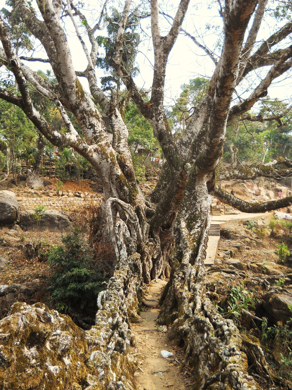
Sadly, the tree that the root bridge is a part of seems to be sick. The bridge may not be long for this world.
NONGBAREH 2:
This is a highly unusual, double span, living root bridge below
Nongbareh, on a path that leads down to the river Umngot. My guide, a
man named George, was of the opinion that I was the first outsider ever
to reach it. I'm not entirely sure if that's true. However, these are
the first pictures of this bridge ever to be published online.

George climbing down steep stairs to the living root bridge.

Here, you can clearly see the unusual, double span, configuration of the
root bridge. Why the original planters of the bridge decided to make it
this way is anybody's guess.

The view of the double span from upstream.

Looking up at George. The secondary roots hanging down from the span,
which have had the time to grow and strengthen, would seem to indicate
that this is a very old bridge.
KHONGLAH: 6 BRIDGES
Khonglah is a mid-sized, and very pleasant, Jaintia village, which has
never seen any tourism. The notion that anyone would want to visit just
for the sake of visiting struck the headman as quite novel.
KHONGLAH 1:
This is a small bridge, which occurs on quite flat ground. The existence
of living root bridges in this area, which is characterized by fairly
gentle rolling limestone country, makes one wonder if there are not
living root bridges in parts of the state of Meghalaya that are less
rugged than the canyon country of the south.

My guides on a small bridge near Khonglah
KHONGLAH 2:
Another small bridge, also in relatively flat terrain.

Despite being so small, the thickness of the roots on this bridge indicate that this is probably fairly old.
KHONGLAH 3:
This is a very small, and clearly quite recent, bridge. It also seems to
have been abandoned before it was completed, as there is a concrete
bridge right next to it. My guides were very puzzled when they saw my
interest in it.

A view of the living root bridge from the concrete bridge.

KHONGLAH 4:
This is maybe the strangest of all known living root bridges. It is
located on the side of an incredibly steep slope, well below Khonglah. I
would be very surprised if any visitor had been here before me. It is
only accessible by hiking for several miles on almost non-existent
jungle paths.

My friend Silent Bob standing on
Bizarre Bridge. How much of the bridge was planned, and how much is a
natural accident, is hard to say. While at first glace, the tangle of
roots seems too haphazard to have been deliberately planned, on closer
inspection, many of the individual roots do appear as though they might
have been trained. For one thing, notice that several of the roots
actually seem to be slanting upwards, against gravity. However, again,
what the advantage of building the bridge this way would be is anyone's
guess. Here, behind Silent Bob, you can just make out the primary
walkway of the bridge.

My guides Benedicttalang and Silent Bob, posing next to the main walkway
of the bridge. From this angle, the structure looks a little more
man-made.
KHONGLAH 5:
This is a very pretty, classic, medium sized living root bridge, well
below Khonglah, on a long and difficult hike down into the canyon of a
stream called the Amdep. I'm reasonably sure it had never been visited
by an outsider before. My camera was malfunctioning at the time, so the
pictures are rather inadequate.

Benedicttalang on the center of the bridge.

The span of Khonglah 5
KHONGLAH 6:
This was a fairly major discovery. Khonglah 6 is a long (perhaps 100
foot) living root bridge that spans Amdep creek. It had never been
visited by an outsider before. The round trip to it was about 6 hours of
straight up and down, so a major investment of time. The last time
Khonglah's headman had been there was 40 years ago. The bridge is near
several wonderful, clear-water swimming holes, and, for someone in
reasonably good shape, reaching it is the best hike (that I experienced)
in Khonglah.

Silent Bob standing on the living root bridge. Other than simply being a
very long bridge, and being in a fairly amazing, jungle-canyon,
setting, Khonglah 6 is remarkable because it seems to be an example of
an old living root bridge that was partially washed away in a flood, and
then reconnected. Note how much thicker the roots appear to be on the
left side of this picture. On the right side of the bridge, some of the
roots had been trained along metal wires. How long the bridge has been
there, and how long ago the right side of it was partially washed out,
is impossible to say.

The living root tunnel at the undamaged end of the bridge.

Benedicttalang and Silent Bob on the living root bridge.

This is the view of the bridge from upstream. From here, it appears as
though what happened was that, when the flood came through, many of the
secondary roots along the span were knocked out, though the two main
roots managed to hold on. It illustrates another way in which the living
root bridges are unique as a form of architecture: As long as the
organism, the tree itself, survives, a bridge that is broken can be
reconnected and started again.
PADU: 3 BRIDGES (2 others known to exist but not visited)
Padu is a village that is starting to see a trickle of visitors, so its
bridges are far less obscure than those of Nongbareh or Khonglah. The
hikes to the living root bridges here, which also happen to be in the
canyon of the Amdep (though several kilometers upstream from Khonglah
6), are far less brutal than elsewhere in the area, while the bridges
themselves are some of the most beautiful known examples. Padu certainly
has the resources to challenge any current tourist spot in Meghalaya.
That being said, a web search for "Padu living root bridges" turns up
only a handful of pictures.
PADU 1:
This is a small, ancient, but truly beautiful, living root bridge, on the way to the Amdep from Padu.

While this bridge is perhaps not the most spectacular in the region, it is one of the most perfect.

Note the thickness of the roots, indicating a very ancient structure.

My guide in Padu, Max....he's the tourism honcho in Padu, and a real asset for the village.
PADU 2
This is one of the most spectacular of all known living root bridges, and should be seen as Padu's main attraction.

Padu 2, and Max mugging for scale. That root above the span, that seems
to be being held up by a sort of load bearing member, gives the bridge
one of the most instantly recognizable profiles of any living root
bridge. How that arrangement could have come about, however, is a
mystery to me.

Max on the living root bridge. A cursory glance, again, shows that this is a very old example.

A view of the bridge from the opposite direction.
PADU 3
While Padu 2, is, in my opinion, more beautiful, Padu 3 is more well
known because it is a double (or, arguably, even triple) span living
root bridge. It is also on the Amdep, a short, beautiful, and not
especially difficult, walk downstream from Padu 2.

Max on Padu 3. That's a column of concrete to the right. At some point,
the bank under the bridge appears to have been undercut, so the concrete
column was used to shore up the structure. It's rather unsightly,
though it's hard to imagine that the structure would stay standing
without it.

Looking up at the two separate spans.

The parallel spans of Padu 3, with Max messing around on his smartphone.
Unfortunately, the span on the left was covered in concrete...though
doesn't seemed to have harmed the trees much.

Looking up at the living root bridge from downstream.
KUDENG RIM: 3 BRIDGES (others probable though not visited)
Like Padu, the village of Kudeng Rim is starting to see a tiny trickle
of visitors. A tour outfit called Cultural Pursuits seems to have led a
few of their clients here. Also, a fairly poor quality photo of one of
Kudeng Rim's living root bridges appears on a website belonging to the
tourist department of the West Jaintia Hills District. However, the site
simply lists the bridge as being in "Kudeng" (there are in fact two
Kudengs, Kudeng Rim and Kudeng Thymmai).
A google search for "Kudeng Rim living root bridge" only gives one
relevant result: The poor quality photo from the government website.
In terms of activities and things to see, Kudeng Rim could give even
Nongriat in the Khasi Hills a run for its money as a tourist spot,
though at the moment the villagers at Kudeng Rim don't appear much
interested in developing their tourist infrastructure.
Note that there is another fascinating structure, a tree that has been
modified into "living root bleachers" in Kudeng Rim, next to the
village's foot ball field. I'll deal with this in the final post in this
series.
KUDENG RIM 1
This is a small, relatively recent living root bridge near the village of Kudeng Rim.

I would have entirely missed the bridge in this photo were it not for
Generous there. A recently built road runs about 200 meters upstream
from here. The living root bridge was probably the main way across the
stream before the road was constructed.

Close up on the span of the living root bridge.

A view from downstream.
KUDENG RIM 2:
This is the most perfect living root bridge in the Kudeng Rim area. It
has the most aesthetically pleasing walkways of any bridge that I've
visited. It's also not an especially difficult walk from Kudeng Rim.
This is the bridge that features on the West Jaintia Hills Tourism
website.

The view across the span of the living root bridge.

Looking up at the bridge from the river.

The bridge is notable for the incredible number of secondary roots that
hang down from it. The living root bridges in the more well known
tourist sites, such as Nongriat, are rather more manicured than those in
the more remote parts of the state.
KUDENG RIM 3 (The Great Bridge of Kudeng Rim)
This bridge is part of one of the most spectacular views in all of
Meghalaya. The bridge itself is a very long one, and actually consists
of two spans, one after another (something which my camera was incapable
of capturing without a wide angle lens). It's also noteworthy because
it's one of the very few living root bridges that are a great distance
above the streams they cross. None of the famous living root bridges in
the Cherrapunji area are more than a few meters above their streams. I
would estimate that the Great Bridge of Kudeng Rim is about 60-70 meters
above the water (it's actually higher than these photos make it look!).
The setting for the living root bridge is also maybe the most incredible
I've seen. It spans a straight-walled canyon, above a significant
river. A short distance upstream, visible in the picture below (again,
looking much smaller than it actually is), is a large waterfall with an
incredible, blue-water plunge pool. It's possible in the dry season to
cross the bridge, climb down into the river, clamber up the boulders to
the plunge pool, and then swim to the base of waterfall....which also
happens to create a rainbow when the sun hits the spray at the right
angle. This spot alone has the potential to make Kudeng Rim world
famous, and the folks at Cultural Pursuits seem to have come here a few
times, though, again, information online is incredibly scarce.
There are, however, a couple of drawbacks. The first is that the
bridge, though spectacular, is also dangerous. It's made from a large
number of fairly thin roots, and a fall from it would prove fatal. The
second is that the beauty of the bridge is rather marred by the fact
that water pipes are being laid across it to supply Kudeng Rim. The
first view one gets of the living root bridge, after hiking down from
the village, is something of a disappointment, and one can only
appreciate the true scale of the structure by climbing onto a stone
shelf a short distance down canyon from the bridge.
A friend of mine from nearby was of the opinion that the bridge, because
it was rather precarious, should be torn down. This would be a
disastrous mistake. The pictures I have posted do not so it justice: If
people simply knew about this living root bridge, it would draw visitors
from all over the globe.

The Great Bridge of Kudeng Rim. The waterfall in the background is maybe
thirty meters high. It's much farther away, and therefore much bigger,
than this picture makes it look. This bridge also looks like it might
have been damaged in the past, though it was not possible at the time I
visited to find out anything about its history.

Looking way up at the span of the Great Bridge of Kudeng Rim

A view of the bridge from upstream, which gives one a better idea of
what the canyon it spans is like. Unfortunately, the lighting conditions
at the time were not optimal. There was no guarantee I would ever be
able to come back, so I had no option but to take the photo practically
staring into the sun. Note the way the tree on the left side of the
living root bridge seems to be almost propped up by its roots. A good
third of the living root bridge is actually to the left of that tree,
though that part of the bridge is obscured in this picture.

This is the first view one gets of the living root bridge, which doesn't
give one any sort of impression of how incredible the structure is. In
fact, as I recall, one only realizes how high the bridge is once one is
about halfway across it...not for anyone with a fear of heights, I'm
afraid...
BURMA VILLAGE: 1 BRIDGE (Double span)
Burma is a Khasi village, on the opposite side of the Umngot from all of
the other villages in this post. Nobody seems to know whether or not
its name has anything to do with Myanmar. While it does not seem to have
a high concentration of living root bridges, it does have a single,
very beautiful example, right in the middle of the village. It is one of
the prettiest Khasi settlements I've been to thus far.
BURMA DOUBLE BRIDGE:
This is another example of a twin span living root bridge. It runs
across a canyon right in the middle of the village, so were you to find
yourself in Burma, locating the bridge would be an easy task.

A kid crosses Burma bridge. The concrete pillar in the background is
part of another, modern, bridge that has been built directly next to the
living root structure, in order to replace it. I was informed by a
member of the village council that Burma's local government has outlawed
damaging the bridge in any way, though he might have just been telling
me what I wanted to hear.

The twin spans of Burma Bridge. Notice how different the two sides are.
They were apparently maintained by two separate people, who had slightly
different styles. There seem to be many more young roots on the left
side than on the right. Notice the houses in the background, and the
children.

The view of Burma Bridge from upstream.
Coming soon: Part 2: Living Root Bridges of Pynursla
Part 3: Living Root Bridges of the Twelve Villages
Part 4: Living Root Ladders, and other uses for living architecture
10 Things to see in Delhi that are not in Lonely Planet

The largely forgotten tomb of Roshanara, world's away from the better known parts of Delhi.
For the second half of this list, please go to: 10 more things to see in Delhi that are not in Lonely Planet
First off, let me say that I am in no way trying to disparage Lonely Planet. I would be a massive hypocrite if I did. I have found their titles incredibly useful over my years travelling in India. I think I've all but memorized large sections of text from several of their guidebooks (particularly their 2011 edition of Rajasthan, Delhi, and Agra). In short, having a Lonely Planet can really make travelling easier.
That being said, no guidebook, no matter how well-researched, is truly
comprehensive. For example, the two most recent editions of Lonely
Planet guidebooks dealing with Delhi, the one mentioned above and their
2013 pan-Indian title, both devote nearly 50 pages to the city, and yet
vast swathes of Delhi's history, landscape, and cultural heritage are
left out.
This isn't the staff at Lonely Planet being derelict in their duty
(except in those few instances where their information is incorrect,
which I'll get to in my next post). Rather, it's a symptom of Delhi's
long and exceedingly complex history. The city's unique position as the
capitol of (as I figure it) eight different kingdoms and empires over
the course of the last 1500 years has left Delhi with an almost
mind-boggling assortment of historical sites. Including all of these in a
single volume would require a book at least as large as the entire
Lonely Planet India title. Every single tomb, mosque, and obscure
complex of ruins can't have an entry...
...but, there are several places which really should be in there, and
probably will be soon. As time goes on, and new issues are released,
many of the blank spaces on the map of the city are being filled in. For
example, it was not until the most recent issue that Agrasen Ki Baoli, in my view Delhi's most impressive step-well and one of its classic sights, was included.
What I'm listing here are 20 things, ten in this post and ten in the
next, which Lonely Planet does not, as yet, include. I have them
organized by region of the city, starting in the north and moving south.
Some of these places are beautiful, some historically important, and
some are just interesting. Some are also difficult to find, hard to
visit, or perhaps of interest only to people with a deep and committed
fascination with Delhi. But one thing that I've learned traveling in
India is this: The sense of discovery and adventure inherent in seeking
out that little known mosque, tomb, or temple, hidden down some side
street of a side street and barely known even to the locals, can be just
as rewarding as a trip to the Taj Mahal.
All pictures are by me, by the way....
All pictures are by me, by the way....
NORTH DELHI:
Virtually all of Delhi north of the Mughal city of Shahjahanabad
(usually referred to simply as Old Delhi), with the exception of
Majnu-ka-Tilla, the city's Tibetan refugee colony, is virgin territory
as far as tourism is concerned. Yet, with its huge expanses of green
and comparatively empty space, North Delhi contains many of the most
pleasant places in the entire city.
1: SHALIMAR BAGH

The creepy but fascinating Sheesh Mahal of Shalimar Bagh.
Located near the current northern end of Delhi's Yellow metro line,
lending it an Ends-of-the-Earth quality, Shalimar Bagh is a huge garden,
first laid out by one of the wives of the Mughal Emperor Shah Jahan
over three and half centuries ago. Now the garden is a surprisingly
extensive wooded area that has been surrounded by an upscale residential
area of the same name. If you do a Google search for "Shalimar Bagh
Delhi", you'll get a number of entries for the neighborhood and not the
garden itself. There are several dilapidated though very interesting
Mughal buildings inside the garden, the largest of which is the Sheesh
Mahal. The surviving buildings have fragments of paintings probably
dating to British times.
Make sure to do your research before trying to get there: It took me
three attempts to actually find the damn place....though it was well
worth it....

19th century paintings in Shalimar Bagh
2: THE NORTHERN RIDGE

Flowers and greenery. Not what one expects out of Delhi.
The Northern Ridge is quite a large omission on the part of the staff at
Lonely Planet. I think if foreign tourists knew it was there they would
come in greater numbers, but as it is, though I've gone there many
times, I don't believe I've ever seen another foreigner unless I had
brought them myself.
The Northern Ridge is a low rocky outcropping, the northernmost
extension of the Aravalli Range (which is much more prominent further
south), covered in dense, scrubby vegetation, monuments from several
different eras in Delhi's history, and by far the largest concentration
of Reesus Monkey's I've ever seen. For anyone who has never seen a
monkey in the wild before, the Northern Ridge is an incredible
expereince: You'll literally see hundreds of them going about their
business, prospering (to an almost frightening extent) in the midst of
one of the world's largest urban areas.
In addition to the area's wildlife and its surprisingly well maintained
walking paths are its large number of historical monuments. These
include several Tughlaq (14th century) era relics, mostly in the
vicinity of Hindu Rao Hospital, such as an obscure step-well, a large,
strange ruin that may or may not have been an astronomical observatory,
and also an Ashokan pillar from the 3rd century B.C., brought to Delhi
by Feroz Shah Tughlaq, who during his reign expended a great deal of
effort bringing two of the ancient columns to Delhi, despite apparently
not knowing what they were...other than very old...and mysterious....
More recent additions, were made to the historical landscape by the
British, who at the time of the Sepoy Uprising famously occupied the
Northern Ridge during the siege of Delhi, using it as their base and
fighting off numerous attacks by rebel Sepoys and Jihadis, before their
final advance on the walled city. Several colonial era buildings, such
as a large signal tower (known as the Flagstaff Tower) and several
ammunition storehouses, still stand.

The mysterious Pir Ghaib, a Tughlaq era ruin on the Northern Ridge,
which might have been used, at least in part, as an observatory.
3: ROSHANARA BAGH

Local children playing at Roshanara's Tomb.
Roshanara was one of the daughters of Shah Jahan and Mumtaz Mahal
(Mumtaz Mahal being the woman for whom the Taj Mahal was built). During
the exceedingly unlovely struggle to decide which of Shah Jahan's sons
would take the throne after his death, Roshanara went against her
father's wishes and sided with Aurangzeb, who would eventually take over
the empire after killing his brother and imprisoning his father.
Roshanara is therefore not well remembered. Her tomb is small by Mughal
standards, and her garden in North Delhi is now much encroached upon by a
British era country club. Yet Roshanara Bagh, or Roshanara's garden,
still offers a surreal respite from the bustle of the city.
There are only two major historical buildings left inside the garden,
both them in moving states of disrepair. The old gateway to the garden
still stands, and has a few remnants of colorful, centuries old, tile
work clinging to it. Inside, Roshanara's tomb is rather a lovely
building, despite the dilapidation. However, be warned: Don't expect
much in the way of solitude here. The garden is very much a local
hangout spot, and if you visit you'll find yourself dodging through at
least twenty different cricket games.

Ruminations near sundown at Roshanara Bagh.
4: QUDSIA BAGH

The mosque at Qudsia Bagh
The southernmost of our great green spaces in North Delhi, Qusia Bagh is
a fragment of an 18th century garden laid out by Qudsia Begum, a dancer
or courtesan in the court of the late Mughal emperor Muhammad Shah, who
maneuvered her way to becoming queen, and then the mother of the next
emperor, which allowed her for a certain time to maintain de-facto
control over what little remained of Mughal authority.
The historical buildings in Qudsia Bagh date to an interesting period in
the history of Mughal architecture, when the grandest Mughal building
projects were well behind them, yet they still commanded enough
resources to put up monuments that even to this day project a sort of
debased opulence (The much derided tomb of Safjarjung further south
being the most famous example of a monumental Mughal building project
from this period). The main surviving structures in the garden are a
large gateway and a mosque, both of them with remnants of somewhat
over-the-top decorations clinging to them.
The size of the garden today is much reduced from its historical extent,
while the few historical buildings that remain are not in good
condition, their recent half-hearted restorations having unfortunately
contributed to rather than halted their degeneration. The whole garden
was damaged terribly during the Sepoy Uprising, when it was situated
between the British position on the Ridge and the Sepoy army inside the
walled city of Delhi. Yet the garden is still a very pleasant place to
visit, and despite their condition the two main buildings are well-worth
the effort of reaching them.

The old gateway in Qudsia Bagh
OLD DELHI:
As far as tourism is concerned, Old Delhi, historically known as
Shahjahanabad, is a study in contrasts. Parts of the old Mughal walled
city, such as Chandni Chowk and the Delhi Red Fort, are among the most
visited places in all of India, but the tangled back lanes of Old Delhi,
despite being mere meters from the more famous locations, remain mostly
unexplored.
Lonely Planet lists the major sights, and also a few of the more
important bazaars, however the books give virtually no information on
what there is to see down the back lanes. This is something which will
probably change soon: Exploring the tangled alleys, mosques, temples,
and crumbling mansions of Shahjahanabad is one of the most fascinating
experiences Delhi has to offer.
5: DHARAMPURA JAIN TEMPLES

A shrine inside a minor Jain temple in Old Delhi
The most recent edition of Lonely Planet lists only one Jain place of
worship in Old Delhi, directly across from the Lahore gate of the Red
Fort. However, there are many more in the city, the most interesting
examples being tucked away in back lanes between Chandni Chowk and the
Jama Masjid. This area is known as Dharampura, and certain parts of it
see a steady stream of foreign tourists. Dariba, which is one of the
main side streets off of Chandi Chowk and specializes in silver jewelry,
is often visited, but tourists rarely go beyond the silver shops.
However, simply plunge into the back lanes behind Dariba, and you'll
almost certainly blunder into a fascinating old Jain temple.
Unfortunately, the caretakers usually don't let visitors take pictures
inside, but suffice it to say that the interiors of the buildings,
covered in two hundred year old murals depicting the lives and exploits
of the Jain Tirthankaras (individuals who have attained enlightenment
and liberation from the circles of death and rebirth), frequently
painted with actual gold paint, are some of Delhi's most amazing sights.
See them now...it'll probably not be long before Lonely Planet does
start listing them, at which point they'll become one of Old Delhi's top
attractions!
It doesn't really take precise directions to find the temples: Just
wander around in the streets behind Dariba and you'll find one. One of
the more visited examples is the Jeweler's Temple down Kinari Bazaar.
From Chandni Chowk, simply walk down Dariba until you see the first
major turning to the right. This is Kinari bazaar, and the Jeweler's
temple is about 250 meters up the road. It'll be down the seventh
side-street on the left.You'll know you're on the right street if you
see a line of very brightly painted traditional houses. These belong to
Jain jewelers who have inhabited the street for several hundred years
and financed the building and maintenance of the temple.
But the Jeweler's temple is only one of many incredible temples packed
into this very small area, and the best way to find more is simply to
let yourself get lost!

A line of brightly colored houses, owned by families of jewelers, next to the Jewler's Temple.
6: OLD DELHI MOSQUES

The exceptionally ornate facade of the Masjid Nawab Rukn ud Dawla, one of Old Delhi's classic overlooked treasures.
Old Delhi is famous for its mosques, first and foremost among them being
the superb Jama Masjid, one of the great building achievements of the
Mughal era. Lonely Planet lists this, and a few other of the most
prominent Mughal mosques in the city, but Old Delhi has countless other
Islamic places of worship, and while none of them may be as grand as the
Jama Masjid, their smaller, more personal beauty still makes them very
worth seeking out.
As with the Jain temples of Dharampura, one stands a good chance of
simply blundering into a mosque if one turns down virtually any side
lane. There are literally hundreds of them within the old city, and
almost anywhere you go you'll find one. Mostly, unless it's prayer time,
caretakers inside the mosques don't mind visitors.
One of my favorite obscure mosques, which is also relatively easy to
locate, is near the Chowri Bazaar Metro Station. After exiting the
station, if one goes up the Chowri Bazaar road towards the Jama Masjid,
after about 200 meters you'll come across the tiny but incredibly ornate
late 18th century Masjid Nawab Rukn ud Dawla on the left side of the
street. It's on the roof some shops, which originally would have given
up a certain amount of their profit for the upkeep of the mosque
upstairs (and perhaps still do).

The view of the Masjid Nawab Rukn ud Dawla from the street.
7: OLD DELHI HAVELIS

The most intact 19th century haveli in all of Delhi.
A haveli is a variety of traditional mansion built for an extended
family. They are generally planned around a large central courtyard,
with several stories of inward facing rooms, and a large gate that faces
the street. The buildings were designed so that they would almost
entirely shut out the outside world, and create a totally private
environment for the family who lived in them.
As they were historically the main form of housing for most of Old
Delhi's upper classes, the city once had hundreds of these buildings.
But now very few exist in their original form, and of none of those
which do are listed in Lonely Planet. All that remains of the original
grand Mughal havelis of the 17th century are a few crumbling gates. But
even of the later, smaller, havelis of the 19th century, very little
remains in its original condition.
This is because, unlike tombs, temples, or mosques, havelis are places
where people once actually lived, and while they resided in them, they
constantly modified them, and continue to do so even to this day. While
visiting Old Delhi may seem like a step back in time, its important to
note that, as a place drenched in history, it has also been a place of
almost constant, and often radical, change. While a mosque may serve the
same purpose, in the same way, over hundreds of years, the way people
actually live has changed drastically in the last four centuries. Thus,
most havelis have long since been torn down, or redeveloped beyond
recognition.
Exceedingly few remain in a (partially) original condition, and they are
unfortunately both very difficult to locate, and in appallingly bad
condition. Yet, seeing what may be called Delhi's most endangered
architectural form is a tremendous adventure, though also a sad one:
These buildings, the last of their kind, may not exist by the end of the
decade.
The easiest one to get to is on a side lane just a short distance off
of Dariba. Turning onto Dariba from Chandni Chowk, turn left at the
first significant alley, and then a large haveli courtyard will be on
the right after some time.
The haveli pictured above, which, despite the fact that its falling to
bits, has the most intact courtyard in the whole of the old city, is off
of a street called Ballimaran. Frankly, it's almost impossible to
describe how to find it, which is one of the reasons why such a
historically important building can be allowed to fall to pieces: Nobody
knows how to get to the damn thing. However, it is prominently featured
in the Old Delhi section of Lucy Peck's guidebook Delhi: A Thousand Years of Building, and
tracking that book down is probably your best bet for finding it.
There's a reasonably accurate map, and even if you get lost, you'll find
something else that's interesting.

That giant ruinous gateway in the background is one of the exceedingly few remains of a Mughal haveli from the 17th century.
8: RAZIA SULTANA'S GRAVE

The Archaeological Survey of India marker next to Raziya Sultana's
grave...which seems to be aimed at people who already know who Raziya
Sultana was, namely, Delhi's only female ruler
Raziya Sultana, the daughter of Iltutmish of the Mamluk dynasty of the
Delhi Sultanate, ruled the city briefly in the 1230s. She was said to be
more talented than the other claimants to the throne, and by all
accounts was an able queen, though her nobles revolted against her in
relatively short order (in part because they didn't like being ruled by a
woman), and she was overthrown.
In the entire 700 year course of Islamic rule in Delhi, she was the only
female to rule from the city, and as such is considered one of the most
important female figures in Indian History. It seems odd then that
Lonely Planet does not so much as mention her final resting place, an
ancient stone enclosure, out-dating the founding of Shahjahanabad by
over 400 years, deep in the alleys west of Chowri Bazaar Metro station.
There are a couple of possible explanations for why this may be. One is
that it is not entirely certain that one of the centuries old stone
graves is actually that of Razia....it probably is, but there are other
contenders. Secondly, the graves themselves, along with the enclosure,
aren't beautiful or particularly interesting in and of themselves. It's
their historical association which makes them worth seeking out.
Despite these facts, finding the graves is more than worth doing, and
the experience of reaching them, after trekking deep into the tangled
heart of Old Delhi, is unforgettable.
The graves can be most easily reached from the Chowri Bazaar Metro
Station. Simply walk down Sita Raam Bazaar road (which is the major road
directly to the west of the station) about a kilometer until you come
to a place where the road makes a sharp turn to the right. There, just
ask for directions, and you should be able to make your way through the
narrow alleyways to the graves....the locals there seem well aware that
the only foreigners who come to the area are trying to find Razia
Sultana's final resting place.

The graves themselves...not much to look at, but it's a worthy adventure
getting to them, and the history's interesting. One is (probably)
Razia's, while the other may or may not be her sister's...and don't ask
me which is which. I don't think anybody really knows....
SCATTERED SOUTH DELHI SIGHTS
South Delhi is a vague geographical term which applies to the vast
region directly south of Government area of New Delhi. In a way, it is
both newer than New Delhi and older than Old Delhi. In the 21st century,
it is the city of the recently rich. Most of the posh neighborhoods
here are a mere few decades old (by comparison, New Delhi mostly dates
from the early 20th century.) South Delhi is a place of expensive real
estate and giant shopping malls, world's away from the tranquility of
the North's gardens and the chaos of Old Delhi. It is very much a part
of the "New" India.
But hidden in the mazes of recently built upscale housing are remnants
of the vast majority of Delhi's pre-Mughal history. Chronologically, the
first four out of the seven historical cites of Delhi were built in
this area, and while a few of the better known monuments from these lost
settlements are mentioned prominently in the Lonely Planet, the
overwhelming majority of the sights in South Delhi languish in
obscurity, swamped by the 21st century and almost entirely ignored by
visitors.
The next few entries are things to see which do not fall in any of the historical cities of Delhi.
9: KOTLA MUBARAKPUR

Inside Mubarak Shah's Tomb
Walking the half kilometer north of South Ex Market, one of Delhi's
fancier upscale shopping areas, to Kotla Mubarakpur, a small village
quite literally engulfed by Delhi's rapid southward expansion, is a
massively disorienting experience.
At one time, not very long ago, Kotla Mubarakpur was a rural settlement
on the outskirts of Delhi, quite some distance from the city itself.
Only a scant few decades ago it would have been surrounded by fields,
but these were bought up by the city, and developed, though the
villagers decided to remain where they were. What this has resulted in
is a bizarre situation where you have very newly built late 20th and
21st century development directly next to a centuries old agricultural
village, which, despite the onslaught of concrete and modernity, retains
its basic, essentially rural, layout (even if the villagers aren't
engaged in farming anymore).
The village sprang up in the tomb compound of Mubarak Shah, the second
ruler of the Sayyid dynasty of the Delhi Sultanate, perhaps the least
successful Muslim rulers of the city, their authority extending barely
beyond the borders of Delhi itself. Presumably, the walls of the
compound provided some degree of protection. These walls have long since
disappeared (except for a few fragments of two of the gates), but their
location can still be discerned by a small rise in the ground and by a
sudden change in the layout of the streets: Leaving the 21st century and
walking over the ghost of the old walls, one suddenly finds oneself in
alleyways darker and more claustrophobic than those in Old Delhi. Though
most of the traditional housing has disappeared, the street plan of the
village remains as it was hundreds of years ago.
It's therefore a congested place, and beautiful is not the word I would
use to describe it. Mubarak Shah's Tomb, the second octagonal tomb built
in Delhi, is at the very center of the village, and is quite an
impressive piece of architecture, but the village is crowding it in so
much that it's almost impossible to appreciate the building properly. It
is, however, possible to go inside, and to climb up on the roof. There
is also a small mosque, from the same period as the tomb, down a narrow
(and admittedly horribly filthy) alleyway.
If you visit Kotla Mubarakpur, be advised that people there will not be
expecting you. However, I found the locals there to be unusually
friendly towards me, at least by Delhi standards. The village is miles
from anything in the Lonely Planet, and visiting it gives one a genuine
feeling of exploration.

The 15th century mosque at Kotla Mubarakpur, kids flying kites, hideous concrete, satellite dishes, and a plane taking off.
10: MOTH KI MASJID

The wonderfully decorated gate to Moth Ki Masjid
Moth Ki Masjid, or "Lentil Mosque" is another important medieval
building hemmed in by the urban sprawl of South Delhi. While the
environs of the ancient structure might not be quite so claustrophobic
as those around Kotla Mubarakpur, the building nonetheless has the feel
of a last remnant of the 16th century being rapidly swallowed up by the
21st. The mosque is undeniably beautiful, and while it receives no
mention in the Lonely Planet, they might consider making some space for
it. It's one of the most aesthetically pleasing, and also best
preserved, mosques from its era, and it would be a massive shame if the
building was allowed simply to decay in obscurity.
There are several (conflicting) stories as to why the building was given
the odd title of "Lentil Mosque." The basic gist of the more famous
story is that one day a courtier of Sikander Lodi by the name of Miyan
Bhoiya was given a lentil from the floor of the Jama Masjid by the
sultan. Miyan Bhoiya, thinking that such an illustrious bean from such
eminent hands should immediately be planted, did so, and from that
special bean raised a very profitable crop, the proceeds from which he
used to build the mosque.
Those are only the bare bones the story, and no single account that I've
read of the reason behind the mosque's unusual name agrees 100% with
another. But, stories aside, Moth Ki Masjid is worth seeking out. It's
in an area of South Delhi called South Extension II (south Ex. II).
Unfortunately, it's not especially near any metro stations, but if you
type "Moth Ki Masjid" into Google Maps, it's location is fairly
obvious.

One of the impressive corner turrets of Moth Ki Masjid
Ten more things to see in Delhi that aren't in Lonely Planet coming soon!
10 More things to see in Delhi that are not in Lonely Planet

A corridor in Khirki Masjid, one of the most atmospheric historical
places in Delhi, and also one of the city's most under appreciated major
monuments
For the first half of my write up on what Lonely Planet missed in Delhi, go to: http://evenfewergoats.blogspot.com/2014/12/10-things-to-see-in-delhi-that-are-not.html
Starting right in the middle of South Delhi, here are ten more
interesting places to visit in that sprawling metropolis which are not
included in the most recent editions of Lonely Planet.
SCATTERED SOUTH DELHI SIGHTS (continued)
The next two entries are clusters of interesting monuments that don't
fall directly inside any of the classical "Seven Cities" of Delhi. While
you might not feel the need to go out of your way to visit any single
one of these lesser known sites, spending several hours going from one
forgotten monument to the next, tracking them down through mazes of posh
housing, receiving all manner of inquisitive looks, certainly gives one
a sense of accomplishment (and burns calories). It is easy to get lost
in South Delhi, especially since even the locals frequently don't know
where the monuments are, but the upside is that South Delhi is so full
of forgotten old tombs, mosques, and historical buildings of unknown
usage, that getting lost on your way to one tomb often means stumbling
into another.
11: ASSORTED TOMBS NEAR SOUTH EX. MARKET

Part of the unusual tomb of Darya Khan Lohani
South Extension Market is a fairly nondescript, upscale South Delhi
commercial area. Within very easy walking distance is a high
concentration of interesting, though very obscure, Lodhi period tombs.
Buried as they are in upper middle class neighborhoods, the tombs are
well hidden, though more than worth seeking out.
Of the tombs, the most unusual is that of Darya Khan Lohani, a court
judge and later advocate to the kings of the Lodhi dynasty. His tomb has
an unusual layout, consisting of a square platform with cupola's at
each corner. Though much ruined, the cupolas retain traces of incised
plaster calligraphy. While mausoleums of this sort were apparently at
one time not uncommon, most of the other examples have either
disappeared, or have been remodeled beyond recognition, meaning that the
tomb of Darya Khan Lohani is important from the perspective of Delhi's
architectural history.
North of Darya Khan Lohani's tomb is a small park containing two
interesting tombs (there is a third, in poorer condition, next to a
temple across the street). Their occupants are unknown, though it's
possible to judge, based on the style, that the tombs are also from the
Lodhi period. The larger of the two is the impressive Bare Khan ka
Gumbad, of interest chiefly for its facade, which has an unusually large
number of arched niches. The other tomb, the Chhote Khan ka Gumbad,
retains large fragments of the original plaster and tile work that once
covered the outside. Unfortunately, the places where the original work
has fallen off have been covered, in an ill-thought out restoration
attempt, with horrendous pink plaster. Still, the tomb is said to have
an interesting and well preserved interior, though at the time I visited
the man with the key to the mausoleum was nowhere to be seen.

The impressive Bare Khan ka Gumbad
12: ASSORTED MONUMENTS NEAR THE HAUZ KHAS METRO STATION

The creepy Chor Minar
The are several interesting monuments within very easy walking distance
of the Hauz Khas metro station, roughly between Aurobindo Marg and the
line of the walls of Siri Fort (now largely taken up by upscale housing
and a sports complex..see the next entry).
Of these, the most famous is the Chor Minar, a 13th century rubble
masonry tower built by Allauddin Khilji, one of Delhi's more striking
early Islamic rulers. Chor Minar means, roughly, "tower of thieves" and
local tradition holds that the heads of captured robbers were displayed
in the 225 holes that wind around the outside of the tower. While this
may or may not be true-the name "Chor Minar" seems to have been recently
bestowed-Allauddin Khilji is known to have beheaded large numbers of
Mongols and then hung their heads near the walls of his military
stronghold at Siri Fort, both as a warning to the Mongol armies to the
north, who were during this period history constantly harassing India's
western boundaries, and to populations of Mongols inside the Khilji
Kingdom who might be tempted to join their brethren on the other side of
the Indus. This might therefore be the origin of the tower's
association with severed heads. Certainly, no matter what the actual
facts are, there definitely seem to have been severed heads involved
somewhere, and a visit to the tower makes for an unusual, macabre,
excursion.
Located roughly 500 meters to the east of the Chor Minar, though only
accessible by rather a circuitous walk through the very upscale Mayfair
Gardens neighborhood, is the Tomb and Mosque of Makhdum Sahib. This is
an obscure little group of Tughluq and Lodhi period buildings, set in a
small park surrounded by fancy houses. Who Makhdum Sahib was is
apparently anybody's guess, though he was evidently important enough to
have a religious complex where buildings went up over the course of an
entire century named after him.
While the buildings themselves, along with the setting, are pleasant in
their own right, what chiefly sets the complex apart is the fact that
one of the tombs still has some old paintings, presumably from the Lodhi
period, clinging to it. While many of the tombs in Delhi almost
certainly once had this form of decoration, there are very few places in
the city where it has survived.

Paintings in the one of the tombs at the Makhdum Sahib complex
SIRI
13: THE RUINS OF SIRI FORT

Ruinous walls are most of what remains of Siri fort
Once, Siri Fort, the vast citadel of one of the Delhi Sultanate's most
important rulers, Alauddin Khilji, was the most impressive and
indomitable example of military architecture in the whole of India.
However, over the centuries large portions of the stone that made up the
fort was plundered and used in later building projects, for the most
part leaving only the foundations of the walls. Now the enclosure which
once housed Alauddin Khilji's military encampment is filled in with an
urban village, a huge 1980s sports complex, and several pleasant green
parks. One can wander for long stretches of time inside the former walls
of the fort and forget it's even there. Lonely Planet does mention the
area, but only the sports complex (which evidently has a swimming pool
you can use for a fee). The closest major tourist spot is Hauz Khas
village, otherwise, visitors seeking out the ruins seem very rare.
And indeed the ruins, both of the walls and of the ancient structures
within, having been abused for six hundred years both by the elements
and by dozens of later rulers of Delhi, are very much fragmentary,
serving only to give faint impressions of what the citadel was once
like. They are interesting, they are atmospheric, but they are not
beautiful.
However, for anyone truly interested in the development of the city of
Delhi, what really makes the ruins of Siri worth seeking out is their
history, for it was from here, in the late 13th and early 14th century,
that much of the great struggle between Allauddin Khilji and the Mongols
of the Chagatai Khanate played out. As the fate of North India lay in
the balance, the fort served as Alauddin's military base against the
Mongols, even being besieged by them in 1299.The Khilji's were
ultimately the victors, and Delhi would not fall to another group of the
descendants of Gengiz Khan's hordes until the arrival of Tamerlane
close to a century later. Hence, the fort's importance in both Indian
and Central Asian history should not be understated.
The fort also holds the distinction of being the first of the seven
cities of Delhi that was entirely constructed by the Muslims. While
Mehrauli was the first seat of Islamic power within the city, its
foundations were Hindu. Siri, by contrast, was constructed entirely by
Muslims. The artisans who went about building the city were exiles of
Seljuk origin, a Turkic speaking people whose rapid spread throughout
central and west Asia a few centuries before served as a kind of dress
rehearsal for the advent of the Mongols and also, incidentally,
precipitated the First Crusade. The city was built in a manner which had
more in common with the fortresses of central Asia and Persia than with
those of Medieval India.
The western edge of the ruins of the fort are located about 800 meters
west of the Hauz Khas Metro Station. Some of the more complete fragments
of the walls are visible from August Kranti Road. East of here,
accessible either from Siri Road to the north, and the Outer Ring Road
to the south, is a surprisingly huge green area, now a park, which still
covers much of what was once the Khilji military encampment. Under the
trees there are a few scattered ruins. The most interesting of these,
pictured below, is located near the western edge of the woods. This huge
haunted looking structure is now in the process of being reclaimed by
nature, and can only be reached by pressing through scrubby undergrowth.
Still, it's worth the effort. What purpose the buildings here served is
unknown. Whether or not it dates from the days of Alauddin's military
encampment is not known. I suspect it's from a later period, but I can't
confirm this. No attempt is currently being made to preserve the
structure.

The huge mysterious ruin in the park inside the walls of Siri Fort
JAHANPANAH
If there is any large swathe of Delhi that Lonely Planet should take a
closer look at, surely it is Jahanpanah, the fourth of the historical
cities of Delhi (following Tughluqabad, which was built after Siri, to
the Southeast). While very little of the city has survived into the
present, the few major monuments that do remain are some of the most
fascinating and most important buildings in Delhi. Unlike a number of
the places that I've listed above, which would only truly appeal to the
hardcore history enthusiast, the major sites in this part of Delhi
would, I think, be of interest to the vast majority of tourists. The
problem is that practically no one has even heard of these places. I've
gone to them all several times, and have never seen another visitor from
outside of Delhi. This makes a visit to the old mosques, tombs, and
palaces of Jahanpanah one of Delhi's greatest off the beaten track
adventures.
Muhammad Tughluq created Jahanpanah in the early 14th century by
connecting the walls of Mehrauli and Siri, thereby enclosing the huge
swath of empty space that once separated them. This new settlement,
vastly larger than the three cities which had preceded it, is currently
mostly taken up by the modern neighborhood of Malvia Nagar. Inside the
former boundary of the now largely nonexistent walls are a collection of
extraordinary monuments. However, they are all buried deep in
residential areas, and known only to people in their immediate vicinity.
Therefore, it's best to look them up on Google maps before trying to
track them down. The distances involved in Malvia Nagar are huge, and
it's easy to get lost.
14: THE BIJAY MANDAL

An unusual Lodi period extension to the unique Bijay Mandal palace complex
The Bijay Mandal is one of Delhi's most important, mysterious, and
obscure, major monuments. It is medieval Delhi's only surviving palace
complex, and was in use from the days of Alauddin Khilji, through the
Tughlaq period, Tamerlane's invasion of North India, and all the way to
the time of the Lodhi sultans. As such, it was the seat of power of
several of the Delhi Sultanate's most important personalities. In
Alauddin Khilji's time, the Bijay Mandal served as the sultan's living
quarters, while Siri Fort was in all likelihood largely devoted to
military matters. The palace therefore considerably predates the
founding of Jahanpanah.
Muhammad Tughluq, the ruler famous for attempting to move much of the
population Delhi hundreds of kilometers south to Daulatabad in present
day Maharashtra, is thought to have occupied the palace complex, and it
was during his reign that the palace was visited by the well known
Muslim traveler Ibn Batutta. Unfortunately, Ibn Batutta's description of
his time spent there doesn't give much of an impression of what the
palace itself was like, meaning that there are no historical primary
sources which can shed light on how the complex functioned as a
building.
Simply from the scale of the place, one can tell that the Bijay Mandal
was exceedingly important in its day. Yet, the things that make the
complex so unique are also what makes it so confusing: It is one of the
very few surviving examples of a secular, non-military structure from
medieval Delhi, but over the centuries that it was in use it was
remodeled by the different rulers who occupied it. Since historians and
archaeologists have almost no other examples to compare it to, and since
there's no historical record of how the buildings looked in their
heyday, even figuring out what purpose each of the structures in the
complex served is a matter of conjecture.
What remains is a huge jumbled mass of ancient rubble masonry. While the
overgrown ruins are, again, not what I'd call beautiful, they are a
great place to wander around. There is a Tughluq period pavilion on the
top of the main structure that one can access and get good views out
over Malvia Nagar, and there is also a stone columned hall, probably
dating from the Khilji period, which is interesting to explore.
As the crow flies, the ruins are located about 500 meters south of the
Hauz Khas metro station, across the Outer Ring Road. Simply head south
from the metro station, into the residential area, and you should be
able to find your way there. The ruins are set in a large public space
between blocks of apartments.

Masonry and columns in the Khilji era hall of the Bijay Mandal
15: BEGUMPUR MASJID

The impressively aligned entrance way, prayer hall, and central prayer niche of Begumpur Masjid
It is astonishing that something so huge and so interesting could be so
completely overlooked, but the 14th century Begumpur Masjid, one of the
largest, most architecturally sophisticated, and well preserved mosques
of the Tughlaq era, sees few visitors. Like the rest of the monuments of
Jahanpanah, Lonely Planet makes no mention of it. All the times I've
gone, I've had the whole vast building to myself.
There is some controversy as to when the building dates from. Likely, it
was built during Muhammad Tughluq's reign, and therefore shortly after
the founding of Jahanpanah itself. However, there are those who contend
that the building was constructed later, during Feroz Shah's reign.
Either way, in a city known the world over for its beautiful mosques,
Begumpur Masjid holds its own. It's courtyard is so vast that, in the
chaotic 18th century, it sheltered a whole village. Despite the roof of
the colonnaded hall around the perimeter of the courtyard having fallen
in at a few places, the building is remarkably well preserved.
Furthermore, the mosque is particularly worth seeking out because it is
one of Delhi's few ancient buildings of any sort where no attempt is
currently being made to prevent visitors from exploring its dark
passageways, or from climbing up onto its roof. The strange, narrow,
stairways leading up above the prayer hall are particularly
interesting.
Begumpur Masjid is right next to the Bijay Mandal, so it makes sense to
visit both of them in a single trip. A walk in the near vicinity will
also bring you to a large assortment of minor monuments from various
periods.

Colonnaded hall in Begumpur Masjid
16: KHIRKI MASJID

Strange angles and a prayer niche in Khirki Masjid
If I had to name one single place on this list to include in Lonely
Planet, it would be Khirki Masjid, Delhi's most unusual mosque, and one
of its most atmospheric historical sites. Built in the later half of the
14th century, what makes it so extraordinary is that it is one of only
two historical Indian mosques that are entirely covered. Designed by a
recent convert to Islam, the mosque's architecture is in many ways more
reminiscent of Hindu places of worship. In a Hindu temple, less emphasis
is placed on communal gathering, thus the actual worship space in a
temple tends to be covered. In a mosque, the building is usually meant
to accommodate large numbers of worshipers, and therefor the worship
space is generally open to the sky. Khirki Masjid is one of the only
mosques in India to reverse this trend.
The outside of the mosque has the appearance almost of a fortress.
Certainly, it would be an easy place to defend against an attacker. The
inside consists of several long colonnaded corridors, with four square
open courtyards which let in a certain amount of natural light. The roof
has a curious arrangement of nine square groups of nine small domes
(with one of the groups having largely collapsed).
In all of Delhi, there is nothing quite like it. While the mosque is now
closely beset by the buildings of Khirki village, which are literally a
stone's throw away, the interior of the mosque is one of the
exceedingly few places in Delhi where the modern world gets entirely
shut out. Walking inside the medieval corridors of Khirki Masjid is one
of the closest experiences one can have to going back in time in India's
capital. Even in Old Delhi, where an earlier way of life is, to some
extent, preserved, one is still surrounded by motor bikes, electrical
wires, ceiling fans, and advertisements. But in the interior of Khirki
Masjid, what one sees now is very similar to what one would have seen
visiting the mosque when it was new.
However, on top of the mosque's historical significance and unusual
architecture, both things that would make it very worth visiting in
their own right, is its incredible profusion of wildlife. So far in my
life I've never been to a better place to see bats, and that includes
several natural "Bat Caves" that I've visited. There are tens of
thousands of the flying rodents in the mosque, mostly hanging in the
undersides of the peculiar domes in the roof. They do, of course, have
their disadvantages. If you don't care for bats, it's probably better to
give Khirki Masjid a miss, and they certainly don't make the inside
smell nice, but if you have the guts for it, seeing the huge crowds of
thousands of flying rodents in the mosque might just be one of the most
incredible experiences you'll have in Delhi.
Accessing the mosque is unfortunately a bit tricky. For the moment, the
nearest metro stop is Malvia Nagar, though it's still not that near,
and the walk is not pleasant. To make matters even more confusing, the
numerous auto drivers out in front of the metro station don't seem to
know where the historical Khirki Masjid is, though they may bring you to
a different, new, mosque nearby. I've found that the best tactic is
simply to get in a shared auto to the vast Saket Select City Walk
shopping complex, which is almost directly across Press Enclave road
from the mosque. From where the auto stops, simply walk down the left
side of the road, looking into each alleyway as you go. Khirki Masjid is
located about a hundred meters from the road, and you'll be able to
tell you're in the right place when you see an ancient looking masonry
wall down one of the alleys. Yes, it's hard to find, but as one of
Delhi's most unusual and atmospheric places, it's more than worth the
trouble!

Gigantic numbers of bats. All the little glowing pairs of dots are bat eyes!
THE SULTAN GHARI
17: THE SULTAN GHARI AND NEARBY RUINS

The Sultan Ghari, India's first Islamic Tomb, and Delhi's most shamefully neglected major monument
Before moving on to the forgotten sights in the last of the historical
cities in Delhi on this list, Mehrauli, we'll first take a took at a
very interesting, historically important, and totally forgotten, complex
of Sultanate and Mughal monuments, which really don't fit in anywhere
else.
The Sultan Ghari, or Sultan's Cave, is the tomb of Nasiruddin Mahmud,
one of the sons of Illtutmish, the second ruler of the Mamluk dynasty,
and the first Muslim king in Delhi to assert his independence, thus
founding the Delhi Sultanate. While Nasiruddin Mahmud's place in history
may not be as illustrious as that of his father, his tomb is one of the
most historically important buildings in Delhi, as it is the very
earliest surviving Islamic mausoleum, not only in Delhi, but in all of
India.
The building itself is very unusual. It predates the introduction of
true arches (and therefore domes) in India, which would come in a few
decades later, in the less well preserved tomb of Balban, one of
Illtutmish's successors. The mausoleum consists of a courtyard, with
almost fortress-like walls and a prayer-niche at one side. The effect is
rather more like a mosque than a mausoleum. Underneath the courtyard is
a large chamber, where the grave of Nasiruddin Mahmud and another,
unknown, person are kept.
The chamber is a place of worship for both Hindus and Muslims from
several nearby villages, who come to pray every Thursday. Filled with
the smell of incense and old offerings, the chamber of the Sultan Ghari
feels more like a Hindu temple than like the inside of a later Islamic
tomb, and in fact many of the columns used in the construction of the
tomb are reused from ancient, long since demolished, Hindu temples.
The main mausoleum in the Sultan Ghari complex is more than worth
seeking out on its own merits. However, there are also a large number of
other historical buildings that came up around the mausoleum that are
very much of interest, though they are all being treated with shocking
indifference (or were as of late 2013, when last I visited....perhaps
the situation has improved?) Of these other buildings, the one closest
to the main mausoleum is a chattri (pictured in the photo above), which
is said to have been restored, along with much of the tomb, by Feroz
Shah Tughluq. Also nearby, accessible if one is willing to push through a
certain amount of scrubby undergrowth, is a small, ruined, Tughluq era
mosque.
The most remarkable structures in the area surrounding the Sultan Ghari
are the remains of several late Mughal era houses and other
miscellaneous secular buildings. While these ruins are, by Delhi
standards, fairly recent, they are nonetheless exceptionally rare: They
represent one of the very few places in Delhi where a large collection
of residential buildings, in this case, several entire small villages,
have survived into the present.
For the most part the buildings that survive the ravages of time are the
ones that were important to begin with. The houses of ordinary, even
relatively well off, people were usually allowed to disappear. For this
reason, in the modern age we are able to fairly minutely trace the
development of tombs in Delhi from the 13th to the 18th century, but
attempting to explain the development of normal houses over the same
period is a matter of guesswork.
That makes the ruined villages around the Sultan Ghari very important
from a historical perspective. As for visiting them, the downside is
that the buildings (at least when last I went) are in a shameful state
of neglect, and reaching them is rather more of an adventure than it
should be (and not a totally pleasant one). A great deal of thorns need
to be pushed through. An extensive restoration job seems to have been
attempted sometime in the early to mid 2000s, but the "improvements"
have often already been reclaimed by scrubby vegetation. Other than
pilgrims from nearby, the site seems to receive very little in the way
of visitors.
Just getting to the Sultan Ghari itself is also no easy task. When I
went, I started by riding the Delhi Metro Yellow Line down to the
Chhattarpur station (the one immediately after Qutb Minar). From there, I
took an auto to the "Indian Spinal Injuries Center." The hospital was
about 6 kms up Abdul Gaffar Khan Marg, near to a part of South Delhi
called Vasant Kunj. The turnoff to the tomb is about 200 meters west of
the entrance to the hospital, and, at least when I went, the sign
marking the way was so small that you'd practically have to have your
face pressed up against it to know that it was indeed the way to the
Sultan Ghari. The tomb is set about half a km back from the main road,
on an unpaved dirt track.
Unfortunately, just going up to an auto-rickshaw driver and telling him
"Sultan Ghari" will in all likelihood simply confuse him, so, if you
intend on going out and locating the thing, make sure to research it on
Google Maps. For one thing, the satellite images give you a good
indication of the layout of the late Mughal era villages.

Surprisingly Greco-Roman looking pillars in front of the prayer niche of
the Sultan Ghari. The columns were probably taken from significantly
older Hindu temples
MEHRAULI
Having moved south from the Mughal Gardens of North Delhi, through
Shahjahanabad, to the Sultanate cities of Siri Fort and Jahanpanah,
we've finally come all the way south to Mehrauli, the place where the
"idea" of Delhi first developed. As the last, and also earliest, part of
the city on this list, Mehrauli contians things worth seeing from every
age of Delhi's history, from pre-Islamic times, all the way to the
colonial 19th century.
Mehrauli began as the 11th century Hindu Rajput stronghold of Lal-Kot,
or "Red Fort" ( not to be confused with the much later Mughal "Red
Fort", or Lal Qila). Its conquest at the end of the 12th century by
Muhammad of Ghor ushered in Islamic rule in Delhi for the next seven
centuries.Thus, Mehrauli can be said to be the historical foundation of
Delhi: The very concept of the city began here, and then slowly, over
the course of most of a millennium, radiated outward from this point.
Like Old Delhi (which is in fact relatively new in comparison to
Mehrauli), tourism in this area is a study in contrasts. Arguably
Delhi's most iconic building, and one of the top tourist draws in all of
India, the Qutb Minar is the star attraction of the area, the only site
in the entire country which receives more visitors being the Taj Mahal.
Yet, less than a kilometer from the Qutb Minar is a dense concentration
of monuments, from virtually every period in Delhi's history, which go
unnoticed.
Lonely Planet has lately begun to include some of these lesser known
places. The Mehrauli Archaeological Park, for example, which is nearly
as interesting as the UNESCO protected Qutb Minar World Heritage site,
gets well deserved high ratings from the guidebooks. However, Lonely
Planet also presents a certain amount of information about the area
which is incorrect, and which does little to extend tourism into
Mehrauli Village itself.
18: THE ZAFAR MAHAL

The faded elegance of the gate of the Zafar Mahal
It is often said (the quote varying slightly wherever one encounters it)
that the mid 18th century mausoleum of Safdarjung, the final truly
monumental Mughal garden tomb, was "the last flickering of the dying
lamp of Mughal architecture." If that's the case, then the later Zafar
Mahal was the last tiny bit of heat radiating out of the ashes of Mughal
architectural magnificence, long after the fire had been extinguished.
The Zafar Mahal was the summer palace of the last of the Mughal
emperors, who ruled from the Red Fort in Delhi over an "empire" that was
mostly symbolic. The Mughals themselves remained significant as
figureheads, but the extent of their actual political power was largely
determined by the British East India Company. By the middle of the 19th
century, they had lost all relevance as military leaders, and many
members of the royal family were in fact living in poverty.
The gate of the Zafar Mahal, the most prominent structure left in the
palace complex, reflects the fortunes of the latter Mughal emperors:
Still a grand building if taken entirely on its own merits, when
compared with the architectural feats of the house of Babur in it's
heyday, which rank high among the most impressive buildings ever created
by the human species, the gate becomes a symbol of a dynasty that had
fallen irretrievably into decay. This makes the palace one of the most
melancholy places to visit in the whole of Delhi.
Much of what still exists (including the gate) was built by Bahadur
Zafar II, the last Mughal emperor, and largely a puppet of the British,
and later, of the Sepoys of the Indian Rebellion of 1857. A man buffeted
about by historical forces that he had neither the ability nor the
inclination to control, his life, and that of the Mughal Dynasty, ended
on a pitiable note. Banished to Burma, he died and was buried there, not
where he had hoped to be, at a grave site within the Zafar Mahal.
Inside the palace, near the small, well proportioned Moti Masjid (an
earlier building dating from near the beginning of the 18th century), is
a small grave enclosure containing several of the final resting places
of the later Mughal rulers. Far from the overwhelming grandeur of the
garden tombs in which most of the early Mughal emperors are interred,
these are no more than simple, white, marble gravestones. Here lie other
unfortunate later Mughals, such as Bahadur Shah I, Shah Alam, and the
person who would have been Zafar's successor, Mirza Fakruddin, had he
not died before Zafar. But sadder than the gravestones is the empty
space left between two of them: This is the lot Zafar had chosen to be
buried in, before the events of the Seapoy Rebellion spun utterly out of
his control, and he wound up, not entirely by his own choosing, on the
loosing side. Banished to Burma, he died in poverty, and the house of
Babur which had existed in North India for over 350 years was finally
expunged.
The palace itself was built directly adjacent to the dargah of the 12th
and 13th century Sufi saint Qutb-ud-din Bakhtiyar Kaki, the person to
whom the Qutb Minar, the symbol of the arrival of Islamic rule not only
in Delhi, but in the whole of India, was dedicated. While the shrine is
not as well known as some other Sufi places of worship in Delhi, it is
nonetheless just as historically important, as the city of Mehrauli
largely developed around it.
A comparison of the Zafar Mahal and the Qutb Minar therefore makes an
interesting historical counterpoint: While the Qutb Minar represents
Islamic rule's triumphant beginning in Delhi, the Zafar Mahel is
symbolic of its ignominious finish. The termination of the Mughal era
was not only the end of a dynasty, but the end of nearly 700 years of
uninterrupted Muslim dominance in the city.
While what makes the Zafar Mahal most worth seeking out is the history
associated with it, it is also an interesting place to explore. The
complex grew up around several older buildings, including one (possibly)
13th century tomb. The Moti Masjid is a very lovely, mid-Mughal period
mosque, and the main gate, while a far cry from the stupendous
architectural feats of the earlier Mughals, is nonetheless still
impressive, all the more so for it's placement in a congested corner of
Mehrauli village.
Getting there is not difficult: Just go to the Mehrauli Archaeological
Park, head due west along any one of several trails that lead out into
Mehrauli Village. Once in the village, simply ask anyone you meet on the
street for the Dargah (just asking "Dargah"? should suffice), and
you'll get there, as the palace is directly adjacent to the shrine. This
is, however, one of the points where Lonely Planet has made a mistake:
There is a short passage in the most recent edition of the guidebook
which claims that Zafar is buried "between two tombs" and that his final
resting place is to the southwest of the Archaeological Park, on the
banks of the ancient Haus i Shamsi reservoir. The tomb is not between
two tombs, it's due west rather than southwest of the Archaeological
Park, and is still close to half a kilometer away from the reservoir. No
mention is made of the Zafar Mahal itself, which, judging by the looks I
got from the locals when I went, sees very few tourists. This is a
shame, for it is one of Delhi's most moving historical sites.

The space left empty for Bahadur Shah Zafar II
19: ASSORTED MONUMENTS IN MEHRAULI VILLAGE

The (probably) Lodhi period Jehaz Mahal
The village of Mehrauli, adhering to roughly the same street pattern as
when it first developed close to a millennium ago, contains an
incredible density of ancient monuments. Yet, after the Qutb Minar World
Heritage site, and then the Mehrauli Archaeological Park, exceedingly
few visitors make the additional effort to explore the village itself.
This is not helped by the fact that, as mentioned in the entry above,
some of Lonely Planet's information on the area is incorrect.
Mehrauli village is the true "Old Delhi." The settlement here has seen
the entire history of the city, from the Hindu period all the way to the
present day. Just like in Old Delhi, perhaps the most profitable way to
explore the village is simply to wander around without a fixed
objective. Around every corner are interesting old mosques, tombs,
houses, palaces, and fortifications. Also, after walking from the Qutb
Minar, you'll find that the atmosphere here to be almost entirely
different: Though right next door to the world renown tourist
destination, virtually nobody comes this far, so the locals won't be
expecting you.
There are an incredible number of monuments here to choose from.
However, were I to pick two interesting things within the village itself
to visit, they would be the Jehaz Mahal and Gandhak ki Baoli, neither
of which are mentioned by Lonely Planet.
The Jehaz Mahal, meaning, roughly "Ship Palace," is a large, impossible
to miss, building next to the Haus i Shamsi Reservoir (the reservoir
itself having been created at the very beginning of the Delhi
Sultanate). While architecturally very impressive, the actual purpose of
the building seems to be unknown, a pleasure palace being the best
guess. Judging from the architecture, it seems to date from the Lodhi
period. Nearby are several more ruined mosques and tombs. When I visited
the Jehaz Mahal, I was let in by a caretaker who refused to accept any
money...this is exceedingly rare in Delhi, so I hope the same man is
there now.
It might be cheating a little to include the Gandhak ki Baoli on this
list: It is technically a part of the Mehrauli Archaeological Park,
which is included in Lonely Planet. However, it's surrounded by modern
buildings, it's a good distance away from any of the other structures in
the park, and the Lonely Planet does not mention it specifically,
meaning that you wouldn't know it was there, or, for that matter, that
it was worth seeking out, by reading the Lonely Planet. Built partially
out of fragments of ruined temples in the early 13th century by
Iltutmish, it is Delhi's most ancient step-well, and therefore a vital
piece of the history of the first few decades of Muslim rule in India.
The structure has seven levels, though at the time the picture below was
taken, the water level was unusually high. Unfortunately, the caretaker
for the building is often absent, and since he has the keys, when he's
not there it's impossible to get in without jumping a fence....that, however, is fairly easy to do, and if anyone confronts you about it, just play dumb and wander off...

Gandhak ki Baoli
20: THE WALLS OF LAL KOT

Overgrown ancient masonry. A long forgotten bastion of the Hindu Rajput fortress of Lal Kot
The final entry on this list also happens to be the oldest, and the most
off the beaten path. It's easy to forget that anything substantial from
the pre-Islamic period in Delhi survives, other than the ubiquitous
reused Hindu temple columns one sees all over Mehrauli. Yet, while they
seem to be almost totally forgotten, large portions of the original
walls of the Hindu Rajput city still stand. Forlorn, covered in cactus
and scrubby vegetation, and now unprotected, the walls of the ancient
city of Lal-Kot are where Delhi began.
While the walls might not be as immediately impressive as the later
Islamic period fortifications in Delhi, such as those of the Red Fort or
Purana Qila, that so much of their stonework has remained after 800
years of the city's cataclysmic history is a testament to the
engineering abilities of the medieval Rajputs.
Visiting the walls is about as far as one can get from the usual tourist
itinerary in Delhi. The most intact part of the fortifications run
through a surprisingly lonely, forested area due west of the Qutb Minar
World Heritage site. To find the walls, head first to Adham Khan's tomb.
This is the huge dome that you'll be able to see all the way from the
Qutb Minar metro station, and after the Qutb Minar itself is Mehrauli's
most prominent landmark. There is a road that leads straight west from
the tomb, and after about 250 meters, you'll pass by one of the bastions
of the of the ancient fortification. You can climb up onto this, and
then continue for some distance along the ridge of the ruined walls. A
word of warning: When I went up onto the wall, the access point was
covered in garbage. The situation may have improved recently, but I
doubt it. Needless to say, visiting the walls of Lal-Kot is a genuine
adventure, and you probably shouldn't do it alone.
From the top of the fortifications, one is afforded what may be my
favorite view in India's capital city: A wide vista encompassing all of
Mehrauli, from Adham Khan's Tomb to the Qutb Minar, with Delhi
stretching out infinitely to the horizon beyond.

The view from the fortifications of Lal-Kot, with Adham Khan's Tomb on
the right, the small but prominent tomb of Azim Khan in the center, and
the Qutb Minar on the left.
That ends my posts on twenty things to see in Delhi that are not in
Lonely Planet. Note that this list is very far from being all inclusive.
Even now, after six years of travelling in India, and after spending
many months in Delhi, there are still large parts of the city that I
have yet to visit. But for someone with a taste for adventure and for
seeking out the obscure, Delhi's collection of interesting places to see
is simply inexhaustible.
Regarding sources, the best guidebook for the lesser known places in Delhi is still Lucy Peck's Delhi: A Thousand Years of Building. However,
that book is now a decade old, and Delhi has changed a great deal since
it came out. Make sure, if you're trying to reach the sites listed
above, to consult other resources such as Google maps, as many of the
maps in Lucy Peck's tremendous guide book are unfortunately out of date.
Hyderabad (V2)

The spectacular chandeliers of the Kilawat Mubarak, the durbar hall of
the Chowmahalla palace, along with the royal seat of the Nizams of
Hyderabad.
And now for something completely different. In October of last year, I
spent a little over two weeks exploring the fantastic state of Karnataka
(and a little bit of Andhra Pradesh), in southern India. Despite the
fact that Northeast India is perhaps the most inaccessible part of the
county, by an odd set of circumstances it's the part that I now know
best. But I had never been south of Agra (with the exception of the
Andaman Islands which are something else entirely). This was my first
foray into the south, and hopefully there will be many more to come.
My plan was to land in Hyderabad, and then travel overland to
Bangalore, visiting Bidar, Bijaipur, Badami, and Hampi, on the way.
Hyderabad hadn't really been an objective in and of itself: I chose to
fly in there because it was the most convenient place from which I could
access Bidar. I spent less than 30 hours there, and hence it was the
place on my route which I explored the least. But, from what little I
saw, it is a fascinating city, and well worth a trip in and of itself.
I landed at about 10 PM, was settled into a hotel in the
Abids neighborhood by twelve. I hadn't eaten anything since dinner the
night before at my girlfriend's friend's house (who happens to be from
Hyderabad...go figure). I wound up having lunch at a vast, busy, Islamic
style dinning hall, along similar lines to Karim's next to the Jama
Majid in Delhi. I got some funny looks from the locals, though the
mutton biryani was mighty tasty, and dirt cheap to boot.
By this point it was already fairly late in the afternoon. Still, I
decided to go out make the most of my time in Hyderabad. The first thing
I did was go down to the Charminar, Hyderabad's main landmark, and one
of India's most iconic buildings. If you happen to be watching a south
Indian movie, and the film needs to establish that we're in Hyderabad,
what you'll see is an image of the Charminar.

One of the minarets of the Charminar. The name translates easily into
"Four Minarets." Not sure what point the saffron flag is making.
The Charminar was built around 1590 by the sultans of Golkonda, one of
the five great dynasties that resulted from the fragmentation of the
Bahmani Sultanate (which was itself an offshoot of the Tughluks of
Delhi). The Golkonda sultans founded Hyderabad, and planned their city
around the Charminar. The purpose of the structure, other than to
celebrate the founding of the city, was to serve as a mosque, though
when I was there it was open during late-afternoon prayers. It was
evidently in fairly poor condition as of the early 19th century and has
since undergone extensive renovation.
The area adjacent to the Charminar is the very heart of Hyderabad. The
monument is now something of a giant traffic circle, around which goes
every sort of vehicle imaginable. While I was there, the wife of
a certain South Indian superstar (mostly in Telugu films) by the name of
Nagarjuna, was taking a tour of the monument. Literally thousands of
people were swarming around her, snarling traffic and congesting the
central artery of the city. A security contingent of around 50 or so
cops was pushing away hundreds of curious folks. I of course tried to
get a look myself, though there were just too many people, and I get the
impression that Nararjuna's wife was rather short.
Anyway, because Nagarjuna's wife was visiting, the Charminar was closed
off, so I decided to head into the area directly east of the monument:
Laad Bazaar.

Bangle apocalypse. Laad Bazaar.
Laad Bazaar evidently goes back to around the time Hyderabad was
founded, and then as now, it specialized in Bangels. There's one shop
after another after another selling bangels, bangels, bangles, and more
bagels, while if you go into the lanes behind the shops and walk a short
distance, you come to the workshops where the bangles, bangles,
bangles, and more bangles, are being made.

Laad Bazaar workshop. As you can see, they're making....bangels. The
word "Laad" is evidently a term for the sort of lacquer used in
Bangel-making.

A surreal view through wires and scaffolding of one of the Minarets of
the Mecca Masjid, a mosque also dating back to the late
Golkonda Sultanate period, being renovated. In 2007, the mosque was the
site of a bombing by Hindu extremists (the renovation happening in this
picture is not because of the bombing). I had hoped to visit
the mosque later in the day, but unfortunately when I got back there,
prayers were being conducted, so I had to skip it.
From Laad Bazaar, if you walk to the first intersection and then turn
left, you'll come to the Chowmahalla in around ten minutes. The
Chowmahalla was the residence of the Asaf Jahi rulers of Hyderabad, who
broke away from the Moghuls in the early 18th century. The Moghuls, in
turn, had absorbed the Golconda Sultanate, and the Asaf Jahi's, now
usually referred to as the Nizams, had started off as their governors in
the region.
The reign of the Nizams lasted from shortly after the death of the
Moghul emperor Aurangzeb to the mid twentieth century. Through the Raj,
Hyderabad was one of the very richest princely states in British India,
and after Indian Independence, the Nizams made an attempt
to remain separate from the India, though they were ultimately annexed
to the country by force.
Chowmahalla means "Four palaces," "Chow" evidently being a local
rendering of "Char", as in, "Charminar." The compound consists of a
number of buildings in a hybrid, and not always successful, East-West
style, along with a series of displays of the Nizams erstwhile wealth.
The place was closed as of 2010, but has since been restored and opened
up as a museum, with the financial aid of the Tatas. [REVISION: A reader
below has pointed out (has, rather, pointedly pointed out) that the
restoration project was begun by Esra Jah, the wife of Nizam
Mukarram Jah Bahadur Asaf Jah VIII, the still reigning Nizam. My
confusion might have come from the fact that another former palace of
the Nizams, the nearby Falaknuma, was restored and opened by the Taj
group of hotels, which is part of the Tata business empire. As I
remember, there were plaques or sings up all over in the Chowmahalla
bearing the Tata name...it's also worth pointing out that the
architecture firm that worked on the Chowmahalla restoration has also
worked for various Tata concerns. Hence, though it does appear to
me that much of the money for the project seems to have come from the
Nizams themselves, there also appears to have been some Tata
involvement....hence my confusion...]

Horse drawn carriage in Chowmahalla.

Photo of a photo of Nizam Mukarram Jah Bahadur Asaf Jah VIII, the
current Nizam, as a little boy. Born in 1933, married at age five to a
Turkish Princess, he was apparently the richest man in India for a
while, along with being ( through his marriage) a prince of the Ottoman
Empire, a personal friend of Nehru, and an Australian sheep farmer
(????). He's still around, though his wealth is much reduced to a paltry
one billion dollars.

Another view of the Khilawat Mubarak, by far the most impressive part of
the Chowmahalla. This is where official ceremonies were
held. Apparently the chandeliers had been in storage for quite some
time, and were recently dusted off and re-hung.

A grotesque display of killing implements. A person I knew once
described India as "The land of peace." Sadly I think he was mistaken.

Big ax, Chowmahalla.
After a quick tour around the Chowmahalla, I headed back over to the
Charminar. Now that it was later in the day, the light was rather
better, and Nagarjuna's wife had gone.

Local flavor: Laad Bazaar, a burka-clad woman, an ice-cream cart, and
the Charminar rising above it all. Note the people in the arches to
either side of the clock on the Charminar.

A sign for a one of the workshops in Laad Bazaar, along with some
quality PVC furniture. That guy to the left was very happy that I took
the time to photograph the sign. He made me promise I would post it
online, so here it is.
It's possible to actually go inside the Charminar, though,
unfortunately, they don't allow you to go all the way to the top of
the minarets. Still, you get an interesting view out over the center of
Hyderabad.

View north from the Charminar, through the Char Kaman, a gate which was
built at the same time as the Charminar (though in it's current form has
been much restored).

The view south from the Charminar. The open space to the right is the
courtyard of the Mecca Masjid. The multiple domed building to the left
is actually a government run hospital.

Charminar Dental Hospital, otherwise known as Satanic Parker Posey's lair.
After visiting the Charminar, I retreated to my hotel in order to get a
full night's rest (I had only slept around four hours the night before).
However, I did have one experience worth mentioning on my way back. I
was riding in a auto-rickshaw, and another auto was driving next to
mine. The driver of the other auto must have been desperate to make some
extra money, because as he dodged in and out of traffic, doing his best
to remain parallel to my auto, he was simultaneously trying to get me
to buy sunglasses from him. This meant that, with one hand, he
was steering the auto, but with the other he was reaching over and
shoving sunglasses in my face...me, my driver, and the other
driver's passenger all had a good laugh.
The next day, my objective was to get all the way to a town called
Bidar, which is just across the border in Karnataka. But, having gotten
up relatively early, I decided I would have enough time to explore
Hyderabad a bit more, providing I hurried. I wound up visiting the older
side of Hyderabad: Golconda, and the necropolis of the Qutb Shahi
Kings.
Golkonda fort goes back to the 12th century, to the Hindu predecessors
of the Golconda sultans, though most of the fort that still exists today
is from the 16th century. Ultimately it was knocked over by Aurangzeb
in the 17th century, though Moghul control over the area did not last
long, as the Nizams broke off in the early 18th century.
My visit to Golkonda and the Qutb Shahi Kings was a rather rushed, hence
I didn't spend as much time at either place as I would have liked. It
was something of a marathon around Golkonda's walls....But still....

The multiple ramparts of Golkonda Fort, in highly variable states of
preservation. The structure at the very top is the fort's durbar hall.

Armaments in Golkonda Fort. A
Cannon, cannon balls, and large circular spheres of granite that were
meant to be rolled down from the fort's many parapets.

Huge arches that have been recently restored by covering them in
concrete. The effect is rather incongruous, and also seems to make it
much easier for people to carve their names into the structures. Only a
few of the ruins in Golkonda have been restored in this way, making them
stand out sharply against he unrestored sections.

Dr. Seuss architecture, Golkonda Fort.

Creepy crumbling underground chamber in Golkonda Fort. There are long
stretches of dark, underground passageways beneath the fort, most of
them filled with bats and flying foxes. The underground passages of the
fort are a great place for flying mammals to hide during the day. There
were apparently tunnels built under the fort that lead all the way out
to the center of modern Hyderabad.

The ruins of Golkonda Fort rising up to the Durbar Hall.
Golkonda's chief claim to fame is that it once housed in it's vaults a
number of famous stones, including the Hope and Koh-i-nor diamonds.

The Durga of Golkonda. This is the Ellamma Devi Temple, which was built
by a couple of Hindu ministers of the Golkonda sultans. I don't think
the painting is of any great antiquity, but it makes an impression.

View on the durbar hall, nearing the top of the fort.

A sign outside of the Durbar Hall. I think it speaks for itself.

Overview of part of the fort from the durbar hall.

Deccan style granite boulders, in this case having been incorporated
into one of the strongholds many defensive walls. The boulders here are
very similar to the kind one finds further south in Hampi and Anegondi
in Karnataka (or, for that matter, in Joshua Tree National Park and in
Lone Pine California...however, this is not the granite boulder post...)
After visiting Golkonda Fort, I tried to walk to the tombs of the men
who built it, the Qutb Shahi kings. However, I took a wrong turn, and
found myself wandering out of the city...About the time that I noticed
my mistake was when I realized that I was looking back at the outer
walls of the old city.

Turrets, walls, and a moat: Part of the old outer defenses of the city of Golkonda.

A forlorn random old cannon sitting on one of the turrets of the outer wall.
Of course, getting lost in India is frequently as interesting as getting where you mean to be going.
After taking a quick look at the out walls of the city, I got in the
nearest auto and rode out to the elegant tombs of the Qutb Shahi
Kings. Unfortunately, it was getting late, so I only got the briefest
look at the city of mausoleums (and, in truth, took very few good
pictures). I would be perfectly happy to come back and see the place
properly.

The tomb of Abdullah Qutub Shah, who ruled during the 17th century. It
was during his reign that the Moghuls established suzerainty over
Hyderabad, though the Golkonda Sultans still remained nominally in
power. Evidently he received fairly rough treatment at the hands of
Aurangzeb. Still, he sure got a nice mausoleum.

The grave of Muhammad Kuli Qutub Shah, the founder of Hyderabad and the
builder on the Charminar, in the catacombs under his tomb. Above, there
is a large open chamber, directly under the dome, where
another grave-marker has been placed. But the actual body of the sultan
is further down, beneath this second grave marker. This is a fairly
common practice in the Islamic Tombs of India. You have
a similar situation inside the much better known Taj-Mahal.

The Unfinished Tomb of Mirza Nizamuddin Ahmed. Apparently Nizamuddin
Ahmed led a revolt against Abul Hasan Tana Shah, the last sultan of the
Qutb Shahi dynasty, but was defeated. Hence the construction that was
begun on his tomb was never finished. However, though the last of the
Golkonda Sultans succeeded in putting down Nizamuddin Ahmed's revolt,
his decision to try and reassert the Qutb Shahis independence from the
Moghuls didn't turn out so well. Golkonda Fort was besieged and taken
with much bloodshed, Aurangzeb seized the Hope Diamond, and the Qutb
Shahi dynasty came to an end.

Looking up at unfinished dome in the Tomb of Nizamuddin Ahmed.
After that, I had to rush back to my hotel, pack quickly, rush down to
the bus stand, rush to my bus, and then rush to Bidar, the next stop on
my itinerary, and a place that I was able to explore at a much
more leisurely pace. After a four hour bus ride, I was in the state of
Karnataka, where I would stay for the next two weeks.
More to come shortly...
The Exuberant Rickshaws of Bangladesh

A common sight in Dhaka
In May, 2015, I traveled across Bangladesh, crossing the border from
West Bengal and reentering Indian via Dawki in Meghalaya. The country
left many impressions, but one of the strongest was made by its cycle
rickshaws, which were decorated as brightly, colorfully, and crazily as
possible.
Cycle rickshaws are an absolutely vital part of everyday life in
Bangladesh, much more so than any other place I've been. In some areas,
they are the primary means of getting around, and streets are often
choked with them. Wandering in Old Dhaka often means negotiating whole
traffic jams consisting of nothing but rickshaws. Often, one will be on a
major street with no motorized traffic at all, with the sounds of horns
and combustion engines replaced by the much less obnoxious noise of
hundreds of bicycle bells.
It's often said that Bangladeshi rickshaw art is representative of the
dreams of the common Bangla man. If so, his dreams seem to consist of
everything from film stars, to giraffes, sports cars, Chinese dragons,
the Taj Mahal, and Tigers gambling with each other. If those are his
dreams, then the common Bangla man is a bit of an eccentric, but an
engaging one.
Given that the cycle rickshaws are such an important means of transport
in places like Dhaka or Sylhet, the geography of the street in
Bangladesh is really very different than it is in India. In India, in a
place like, for example, Old Delhi, a traffic snarl will consist of
dozens of private cars, bullock carts, trucks, buses, auto rickshaws,
and the occasional cycle rickshaw, all of them looking rather beat up,
dusty, and drab. In Old Dhaka, a traffic snarl will often consist mostly
of cycle rickshaws, and though they might be beat up and dusty, they're
just too exuberantly decorated to be drab. In Dhaka, one might be in
some of the poorest, most squalid areas of the city, where the lives of
the people who there are undoubtedly unbelievable struggles, but the
cycle rickshaws will nonetheless be just as jolly and crazy as ever.
Now every time I'm in Delhi, I have to say, I miss Bangladesh's Rickshaws.

Street scene in Rajshahi, eastern Bangladesh. This city is where the
practice of decorating rickshaws began in the middle of the 20th
century. The larger, auto rickshaw-like vehicles are electric powered.
Note the imported private car in the upper left hand corner. Bangladesh
doesn't have much in the way of an indigenous automotive industry. Most
of the trucks and buses are either Indian or Japanese. The upper
classes import vehicles for their own use, and in larger cities, when
one does see private vehicles, they tend to be surprisingly nice ones.

Unbelievable rickshaw jam snaking around a corner in Dhaka's Old City

Making a U-turn

This was just after a collision. As far as I can tell, rickshaw pullers
in Bangladesh don't care too much if they bang into each other. On
several rides, my drivers would take almost every possible opportunity
to ram the rickshaw ahead of them, and the arguing post collision was
minimal. The drivers rarely had the opportunity to go fast enough to
cause damage.

A rickshaw driver in a poorer neighborhood wondering why he's getting his photo taken.

I took a whole bunch of photos of this guy's rickshaw. Note the
mysterious multicolored-soccer-balls-in-cups like things in front of the
handlebars. After taking a ton of photos of his ride, and causing a big
scene on the street doing it (as evidenced by those four smiling faces
over the drivers shoulder....foreigners are still pretty rare in Dhaka),
I asked the man how much he would charge to take me where I was going.
He quoted a price about four times what it should have been, so I walked
away, though I felt kind of bad about it after taking so many
pictures.

A typical, though very brightly colored, example

Near the Hindu quarters of Dhaka's Old City

Rain cover

A single rickshaw depicting everything from mosques to peacocks to government buildings to trains...plus advertisements....

A common motif one finds on Dhaka's Rickshaws: Tigers gambling and being
attended upon by servants, who are also tigers, with fans. What's the
story here? I have no idea...

Giraffes on a rickshaw in Rajshahi. In that part of the country, the
rickshaws tend to focus more on having one big picture on the back of
the vehicle.

Also in Rajshahi: Helicopter and sports car

A Chinese Dragon. The rickshaw was in the distance, so I had to zoom in. Rajshahi

This was in Dhaka. A crocodile giving out the owner's number

The Apocalypse Taj. Another common motif in Dhaka. It says quite about
the local artistic sensibilities: The Taj is so highly regarded,
usually, because of the impression of purity it exudes through its sober
white marble. The artist here obviously loves the idea of the Taj, but
would prefer it with a bit more color....And giant flowers...

Bangladeshi film stars peering out over a seat

Hand painted wooden ribs of a rickshaw's rain cover...

....another example

Pedals against the tide
Modhera

Looking out through the entrance of the Guda Mandap, or Sanctum Sanctorum, of the Modhera Sun Temple.
The Sun Temple of Modhera is, like Rani ki Vav, one of the few remaining
architectural splendors left behind by the 10th to 13th century Solanki
Dynasty of Gujarat. I made a brief visit here while in transit between
Patan and Ahmadabad, spending only around two and half hours in the area
(and much of that time was consumed having tea at the Modhera bus stand
with a shady though not entirely disagreeable member of the town
council trying and not succeeding to hustle me out of my Swiss army
knife...he seemed to be hoping that plying me with free Chai would have
the same effect as free alcohol. Anyway.) The stop-off made for a long
day of travelling, but it was more than worth it.
The temple was built in the early part of the 11th century by Bhimdev I,
the same Bhimdev I in whose memory Rani ki Vav in Patan was
commissioned. The temple is dedicated to Surya, the "solar deity" of
the Hindu pantheon, and has rather an unusual layout, consisting of
three main components. The first is a large stepped tank with 108 small
shrines called the Surya Kund. Here, devotes would engage in ritual
ablution before walking up a flight of stairs to the Sabha Mandap, a
free standing building that served as a religious gathering space.
Beyond the Sabha Mandap is the Guda Mandap, otherwise known as the
Sanctum Sanctorum, which was the center of worship within the complex
and housed the temple's primary idol. This was a solid gold statue of
Surya riding his chariot pulled by seven horses, which was placed in a
pit filled with gold coins.The Guda Mandap was designed with such
precision that, only just after sunrise on equinox days, a ray of light
would shine on the idol.
Frequently one hears that the temple was connected to the Solanki
capitol Patan via an underground tunnel, though there is almost
certainly no archaeological evidence for this. While guides love to
claim that there were underground tunnels below just about everything in
medieval India, there are very few places where this was actually the
case (Tughlaqbad in Delhi being one of the only places in India, or all
of Asia for that matter, that actually did have a hidden escape tunnel,
and even that one didn't go on for very long).
Like Rani ki Vav, time has not been kind to the Modhera Sun temple.
During Bhimdev I's rule, Gujarat came under attack from Mahmud Ghazni,
one of the earlier Muslim invaders of India. During one of Mahmud's
campaigns the great Surya idol and the pit of coins were plundered.
Later, the Solanki's recaptured and reoccupied the site, but it was
retaken from their Hindu successors, the Vanghelas, after a few
centuries by a later wave of Muslim invaders, the armies of Alauddin
Khilji of the Delhi Sultanate, who are said to have destroyed much of
the original complex.What one can visit now is therefore only a remnant
of the original temple, yet that what little remains is so grand is in
itself a testament to the wealth and artistic skill of the Solankis in
their prime.
My visit to the site was short, and not at a particularly good time of
day as far as the lighting was concerned. Furthermore, I wasn't able to
learn much about the temple during my actual time there. I did buy a
guidebook, but that proved to be written such awkward English that it
was more confusing than useful. The book is in both English and
Gujarati, and one can only hope that the Gujarati makes more sense than
the English. With such enigmatic statements as: "The level which is seen
visibly depicts the unparalleld specimen of the unique scnlptor of the
sculptorial specimen of stone carvings and construction which reveals
the honours and prestige of being proud and earns the pride of
honourable GAURAV VANTI GUJARAT which at some unfortunate moment has
been attacked by bad and evilements and broken damaged the reason for
and of which are not yet known so far" (all CAPS and spellings by the
author), the guidebook is rather a better souvenir than it is a source
of information. I'm sure the writer's English is vastly superior to my
Gujarati, but, then again, I'm not going around trying to publish
guidebooks in languages I clearly don't have a handle of.
The upshot of this is that my information on the temple is rather
limited. Most importantly I haven't been able to find a guide to the
temple's magnificent sculptures, which is a pity: I would really like to
know the story behind what I was seeing in the thousands of carvings
both outside and inside the principal structures in the complex.

Looking across the Surya Kund to the Sabha Mandap. The Sabha Mandap
originally had a tall Sikhara, or tower, only the base of which remains,
the remainder having been destroyed by Alauddin Khilji.

Looking across the Surya Kund. The reservoir has 108 shrines, the four
largest containing idols of Shiva, Ganesh, Vishnu, and Sitlamata, the
goddess of smallpox, who is worshiped across Nepal and North India.

The Torana, or ceremonial entrance way to the Sabha Mandap. There
probably was once a beam or arch that spanned the opening between the
top of the two pillars.

One of the pillars of the Torana.

Sculpture on the Torana.

Side view of the Sabha Mandap. The building was meant as a sort of
religious conference hall, and has 52 pillars, each of which is
profusely decorated with scenes from the Hindu epics.

The fascinating and intricately carved roof of the Sabha Mandap.

The Guda Mandap, or Sanctum Sanctorum. This building once housed the golden idol of Surya, and also had a Sikhara.

Incredible statuary on the side of the Guda Mandap. The main statues are
of the twelve forms of Surya, known as the Adityas (the leader of whom
is Vishnu), along with the gods of the directions, of whom there are
eight in the Hindu pantheon.

Incredibly dense carvings on the entrance to the Guda Mandap.

Sculptures around the entrance of the Guda Mandap. In the center, the
three seated figures are depictions of Surya, while to the left are
erotic carvings, which are quite numerous at Modhera (though not so
noticeable as on the more famous temples of Khajuraho).

Carvings on the outside of the Guda Mandap.

.........and even more carvings. As I recall, the larger figures were close to being life sized.

One of the most impressive statues on the side of the Guda Mandap.

A large panel depicting Surya, identifiable by the lotus he's carrying,
which symbolizes the sun (he should have two, but the other seems to
have worn off), and by the seven horses that he's riding.
For more on Solanki architecture, go to, check out http://evenfewergoats.blogspot.com/2014/08/rani-ki-vav.html
Agra 1: The Taj Mahal

The Taj at dawn. Now there's a picture I bet you've never seen before.
Actually, this is maybe the world's single most iconic image, but since
the entire tomb complex is oriented around creating this very
composition, you mustn't blame me for taking a cliched snap.
This is the first post in a series I'm going to do on a very intense
week long trip I took to Agra in October of 2013. My two main purposes
in re-visiting Agra were to go to the places I had not been to before
(and there were many), and also to conduct reconnaissance for trips I'm
planning to lead. I had been to the Taj Mahal no less than three times
previously, yet this was the first time that I had the chance to see it
at dawn, so that's where I'll start.
Agra elicits mixed feelings from those who visit. While there are many
people who come to India specifically to see the Taj Mahal, and they are
rarely disappointed, from what I gather, for the average tourist their
visit to Agra is little more than an afterthought. What one frequently
hears is "If I'm in India, I have to see the Taj Mahal."But Agra is
rarely the focus of their trip, the result being that they rush to the
city, sometimes with as little as 12 hours to spare, and only see the
Taj Mahal (usually not in the best lighting, which makes a huge
difference) and maybe some of Agra Fort. This is a pity, as the city has
much more to offer. Also, it's an annoying fact of Indian travel that a
tourist in a hurry is a tourist more ready to part with cash. The
locals who live off of the tourist trade are aware of this, and they
exploit it ruthlessly, making the more frequented parts of Agra tout
gauntlets where if you're a foreigner you can expect to have people
trying to bully you out your money virtually every step of the way.
This gives the city its backpacker reputation as a "Shithole." There is
even a whole class of travelers to India who actively pride themselves
on not seeing the Taj Mahal. Others get so annoyed by the touts and
rickshaw weirdos and crippled hawkers that they forget even to look at
anything, and leave as soon as possible, though not before forming an
overwhelmingly negative impression of the city they failed to see. Then
you have folks who wander around the city feeling superior to the
buildings, who see visiting the architecture as an insufficiently "deep"
or "immersive" experience of the culture. All of these attitudes are of
course perverse: While the Agra experience is one replete with
annoyances, they are merely annoying in the vast majority of
cases, yet the city's architectural wonders are not only some of the
grandest buildings ever constructed, but are some of the greatest
artistic achievements of the human species. In terms of being an almost
impossibly grand concept perfectly executed, you can't do much better
than the Taj, even if its image has become rather a cliche among
cliches.
While some supremely annoying individuals might snort at architecture as
an art form because it does not "say" anything (though architecture
that does "say" something is usually not my cup of tea), the truth is
that architecture is the only human endeavor which can bring out the
same sense of amazement that one feels when confronted with some vast
natural wonder. A writer can describe a landscape, a painter can paint
it, and a photographer can take a picture, but its only through
architecture than human beings can actually create landscapes of their
own. In that respect, architecture is undeniably the most visually
staggering art form, and being in the actual physical presence of an
object so simultaneous vast and beautiful as the Taj Mahal is among the
most overwhelming experiences of a work of art that a person can have.
I think it can be safely assumed that virtually every inch of the
exterior of the Taj, with the exception of parts of the roof, have been
photographed millions, if not billions, of times. I myself took in the
vicinity of 200 pictures during my dawn visit to the great monument, and
I was not alone: Immediately upon opening, well over a thousand
tourists poured into the compound. Though I think the picture above
gives an impression of serenity, in fact the photo was hard won, the
viewing platform I took it from being crowded with 40 or 50 travelers
from every corner of the globe jostling one another to get a perfect
shot of the Taj and it's reflection. As I recall, getting this picture
involved lifting my camera above the heads of a family of super-rich
Brits and hoping it turned out right. I was in no certain terms
denounced as an asshole by a group of middle aged American women (who
were obviously not morning people) dressed in their conception of local
Indian garb. Yes, the Taj is not a place to seek solitude, even at 6
A.M., nor is it a place where one can have any reasonable expectation of
taking a truly original photo, unless there's some very peculiar
lighting or weather condition. The view in the picture above is so
iconic that I can think of two different movies which portray the Taj
being attacked by aliens (Mars Attacks and Men in Black 3).

An upside down photo of the reflection of the Taj. Despite the fact that
even at dawn the complex is crawling with people, early morning is by
far the best time to visit.
The Taj was built between 1632 and 1643 by the fifth great Mughal
emperor Shah Jahan, in order to serve as a mausoleum for his beloved
wife Mumtaz Mahal, who died in 1631 giving birth to pair's fourteenth
child. Shah Jahan's intention was that the mausoleum should be the most
impressive ever commissioned, and a permanent monument of his love for
Mumtaz. The tomb's original name was Rauza-i-Munavvara, or the
"Illuminated Tomb", the current moniker "Taj Mahal" being a corruption
of Mumtaz Mahal. The land it was built on was purchased from the
Kacchwaha's of Amber (and later of Jaipur), the marble also coming from
quarries in Rajasthan.
While it is true that Shah Jahan had several other wives beside Mumtaz,
and that after her death he developed into quite the voracious womanizer
(it is even rumored that he died from an overdose of aphrodisiacs), all
of the evidence points to his having been genuinely in love with Mumtaz
during her lifetime. Certainly, of Shah Jahan's eight children who
survived into adulthood, seven, including the next Mughal emperor
Aurangzeb, were by Mumtaz. While she was alive, she seems to have been
the closest person to the emperor, and his grief at her death appears
genuine. Hence the tomb's overplayed reputation as a "monument to love"
is not inaccurate.
It was during Shah Jahan's reign than Mughal architecture can be said
to have reached it's zenith. A large number of India's greatest
buildings other than the Taj Mahal were commissioned during his reign.
Old Delhi, once known as Shahjahanabad, was largely his conception, and
the two primary monuments in the city, Red Fort and the Jama Masjid, are
both testaments to Mughal architectural sensibilities at their height.
That being said, Shah Jahan was far from a spotless ruler. Before he
gained the Mughal throne, he attempted a large though unsuccessful
rebellion against his father Jehangir. Though he failed in this, a few
years later, upon Jehangir's death, he was able to seize the empire,
though only after exterminating all of his potential rivals, including
his own brother. This was a precedent that would be followed by most of
the Mughal rulers who came after him.
That raises the question of whether Shah Jahan's moral turpitude should
effect ones judgement of the artistic merits of the Taj Mahal. I have
known people who dislike monuments generally for the simple reason that
they tend to have been made by evil people. For my part, I think we're
just sort of stuck with the fact that being a good artist doesn't make
you a good person, and that if you only allow yourself to enjoy art that
comes from perfectly enlightened people living in perfectly enlightened
societies, then you wont have much to enjoy.

A random fellow in the reflecting pool. Or, more correctly, a random
fellow's reflection in the reflecting pool. Note the finial on top of
the dome. This is made of brass and was placed there in the 19th
century, replacing an earlier, gold finial. Though it looks rather like a
trident, traditionally the symbol of Shiva, it is meant to represent
the Islamic crescent moon. However, some view the finial's resemblance
to Shiva's trident as further evidence that the Taj was once in fact a
Hindu temple, which Shah Jahan merely converted into a tomb, after
engaging in a massive conspiracy to leave a huge, false, paper trail and
fool posterity into thinking the building was constructed by the
Mughals. The theory was popularized by P.N. Oak, who also claimed that
the Vatican and Stone Hedge were ancient temples to Shiva, and that both
Christianity and Islam developed out of Vedic traditions. His ideas
seem a tad far fetched to me, though he apparently managed to gain a
certain amount of traction with them. I've had a number of discussions
with people who refused to believe that the Taj could have been a
product of Islamic rather than Vedic civilization.
Whatever people may say against Shah Jahan, the rumors of his cruelty
towards either the workers on the Taj, or to the architect (depending on
which guide you're talking to), are not true. He apparently never had
anyone's hands cut off or eyes gouged out in connection with the
building of the Taj. There are a variety of other myths about the
complex which still have some currency even though there's no solid
proof for them. Perhaps the most common is that another mausoleum,
exactly the same as the Taj except that it would be made of black stone
instead of white marble, was planned directly on the opposite side of
the river, but was either ruined, or never completed (depending on which
guide you're talking to). Sadly, this does not seem to have been the
case.

The eastern side of the main tomb, with the shadow of one of the secondary buildings in the complex crawling across it.

Looking up at the dome.

The mausoleum and the marble platform, with some people for scale, about
ninety minutes after the first picture in this post was taken. The most
distinctive aspect of the architecture of Shah Jahan's reign is the
conspicuous use of white marble. Most of the great buildings of the
earlier Mughal emperors, such as the tombs of Humayun and Akbar, and the
buildings in Akbar's short lived capital Fatehpur Sikri, were made of
red sandstone, a material that was far more abundant in North India. The
great thing about the marble of the Taj is the way it catches the
light: At every time of day there's a different view. At dawn and
sundown the marble goes just as red as the sun happens to be, but in the
middle of the day the building is almost glaringly white...it's rather
like looking at the world's most most colossal and perfectly
proportioned igloo in the bright sunlight.

Looking towards the pishtak of the Taj. In Islamic architecture
the rather undignified term pishtaq refers to an arched opening, which
in this case leads into a rectangular gathering space inside the
mausoleum called an Iwan.

Koranic inscriptions on panels next to the pishtaq, in a style of calligraphy known as Thuluth.

A view of one of the minarets that are positioned on the four corners of
the tomb platform. Apparently over the years several of the pillars
have developed a slight outward tilt, though the Archaeological Survey
of India doesn't expect any of the minarets to topple over anytime soon.
The black strips of stone in between the marble slabs on the side of
the pillar are actually inlaid. The minarets are largely made of either
rubble or bricks, with an outside layering of marble.

Stone inlay work on the side of the pishtaq. The Taj is famous for it's pietra dura,
or hard stone inlay work, which had been imported from Italy during
this period. However, it's often claimed that all of the inlay work on
the mausoleum is pietra dura, when the decorations on the
exterior of the tomb employ methods which had been known to local
craftsmen for quite some time, as evidenced by the other tombs in the
area, such as Akbar's and the tomb of Itimad-ud-Daulah, which
prominently employ inlaid stone decorations. Still, the complexity of
the stone work on the Taj Mahal was unprecedented in India at the time.
Unfortunately, one is not allowed to take photos on the inside of the
mausoleum (though that doesn't stop some). The interior contains the
most ornate inlaid stonework, along with the cenotaphs of Mumtaz Mahal
and Shah Jahan. It's worth taking a small flashlight into the tomb and
holding it directly against the inlaid stone flowers on the side of the
screen that surrounds the cenotaphs. This causes the individual
transparent stones which make up the flowers to light up.
It's funny that over time the Taj has become the symbol of India, given
how many elements of it are essentially foreign. The Mughals themselves
were of course not originally Indians but central Asians, the dynasty
being the decedents of both Tamerlane and, further back, Genghis Khan.
The language of the Mughal court (adopted during the reign of Humayun),
was Persian, and Shah Jahan's taste in architecture was far more Persian
and Central Asian than it was Indian. While with the structures of the
very early Delhi Sultinate, and also with many of the buildings in
Akbar's reign, there is a very distinct, visible, cultural and
architectural fusion, with the Taj Mahal the indigenous characteristics
of the building are much less pronounced.

The view south, from the platform at the northern end of the complex
towards the main gate, across the garden. Other than serving the purely
compositional purpose of providing a means by which one can see the
refection of the Taj, the river at the center of the garden is symbolic
of the rivers that are said to flow in heaven in the Koran. Throughout
much if its existence the garden has been much less orderly than it is
now, with many more large trees.

There are two large red sandstone buildings to the east and west of the
Taj. The one to the west, facing mecca, is a functional mosque, while
the other, pictured above, was built primarily to produce a more
satisfying composition. From the outside it looks almost exactly the
same as the mosque, though it does not have a prayer niche. It's usually
referred to as the Mehmankhana, or guesthouse, and it was used
as such, though it's main purpose was simply to be a pleasing visual
counterpart of the mosque on the opposite side of the mausoleum. Note
the tourists at the lower right and lower left hand of the building for
scale. While only a subsidiary structure in the tomb complex, the
mehmankhana is perhaps as telling of the Mughal's absurd wealth as the
Taj Mahal itself. Were the building standing on its own and not
overshadowed by the most famous man-made structure in the world, it
would still be well worth visiting.

Decorations on the side of the pishtaq of the mehmankhana.

The main arch at the eastern wall of the mehmankhana, which corresponds
to the west, or Mecca facing, main prayer niche of the mosque.

View towards the Iwan and Mihrab of the mosque, looking west. The mosque
is still in use. Every Friday, the whole complex is closed so that
prayers can be held here. The pool in the foreground is for ritual
ablutions for those who are about to pray at the mosque.

Inside the mosque. A man pray's at the mihrab while a Japanese tourist takes a photo.

One of the four spectacular chatris that are positioned at each corner
of the larger, red sandstone platform that the mausolem, the mosque, and
the mehmankhana are on top of.

A view from below the sandstone platform, near the Yamuna riverbank,
looking up at one of the chatris. The view from outside the tomb complex
gives one a more interesting look at the chatris, as you can see the
lowest level, where they merge into the platform, and also the floral
decorations around the outside. Towards the left you can also see the
rear of the mehmankhana.

The main gate into the enclosure that contains the Taj. As an example of
the expert symmetry with which the complex is laid out, note the view
of the pishtaq of the mausoleum proper through the arch of the gateway.

A view southeast from Agra fort towards the Taj. Shah Jahan ended his
life imprisoned in Agra Fort by his son Aurangzeb, who had, like his
father, rebelled and then killed all rival claimants to the throne,
including one of his siblings. This was roughly the view Shah Jahan had
every morning during his imprisonment. After he died, his body was
interred in the mausoleum next to his wife. The overthrow of Shah Jahan
brought about the immediate decline of Mughal architecture. Aurangzeb,
for reasons that are far from totally unjustified, did not encourage
sort of monumentalism that had been a characteristic of most of the
earlier Mughal emperors. He commissioned very few extravagant
buildings, and his burial place, rather than being a grand mausoleum, is
little more than an open grave. The Taj is therefore one of the last,
and certainly one of the greatest, Mughal architectural achievements.
After Shah Jahan, the political fortunes of the dynasty also went into a
long slow decline, until by the mid 19th century it was little more
than a pitiful remnant of its former self locked up in the Delhi Red
Fort, and nothing the Mughals built over the course of those two hundred
years came even remotely close to the grandeur of the Taj.
Agra 2: Agra Fort

Red sandstone carvings in the Jehangiri Mahal of Agra Fort.
Because of its proximity to the Taj Mahal, Agra Fort is the second most
visited historical site in Agra. The fort is one of the most extensive,
and also most intact, collections of Mughal architecture in India. The
Delhi Red Fort is similarly spectacular, and may have at one point been
just as impressive as the fortified city in Agra, but unfortunately time
has not been kind to the fortress in Delhi, which, due to the British
clearance of large parts of the compound after their crushing of the
Sepoy uprising, is little more than a hollow shell of itself. Nearby
Fatehpur Sikri, the short lived capital city of Akbar, also contains a
large concentration of the greatest buildings of the Mughal period, but
they were all built within a relatively short period of time and all
reflect the Indo-Islamic architectural tastes of Akbar's reign. Agra
Fort on the other hand contains a mixture of buildings in both the
Akbari style and in the later, more austere, style of Shah Jahan. Thus
it is perhaps the only place in the world where one can see the very
different architectural styles of the Mughal empire's two most prominent
builders literally side by side.
The site of Agra Fort is known to have been fortified at least as early
as the 11th century, while the city itself seems to go back much
further. The last rulers of Delhi before the Mughals, the Lodis, shifted
their capital to Agra at the start of the 16th century. After Babur,
the first Mughal emperor, defeated the Lodi's at the battle Panipat, he
occupied the fort and made Agra his capital. However, over the course of
the next hundred years the Mughal court would shift several times back
and forth from Agra, until Shah Jahan finally decided to move it
permanently to Delhi.
The fort that exists today is largely the work of Shah Jahan and Akbar,
the original, pre-Mughal fort having been replaced early in Akbar's
reign. Akbar's son Jehangir may have made some additions to his father's
work, but it was Shah Jahan, Akbar's grandson, who made the most
lasting impression on the fort, demolishing many of the Akbari
buildings, and anything that might have been built by Jehangir, and
building many of the fort's most remarkable structures.
I visited the fort first thing in the morning, having woken up well
before dawn and walked there from Taj Ganj, next to the Taj Mahal. I was
the first tourist in the fort, and unlike the Taj, Agra Fort isn't a
madhouse at 6 A.M. I didn't start seeing giant crowds until around 8:30,
by which time I was leaving.
As a place to visit, the fort is a little frustrating because a number
of it's most impressive sites are off limits. All but around a quarter
of the enclosure is occupied by the army, and a large part of that
quarter is not open to visitors. The historical main entrance to the
fort, which, even from a distance, is clearly as impressive as the
Lahori Gate of the Delhi Red Fort, is closed to the public, as is the
white marble Moti Masjid, or Pearl Mosque, which, dating from Shah
Jahan's reign, is said to be for mosques what the Taj Mahal is to
tombs.

The outer walls of the fort, and their reflection in the moat, on the
way in. Guides like to tell stories about the moat having been once full
of bloodthirsty crocodiles.

The Amar Sing Gate, historically a secondary gate to the fort, though
it's now the main way in for visitors. It was once known as Akbar
Darwaza, or Akbar's gate, and served as his private entrance.

Close on the well preserved remains of tile work on the exterior of the
Amar Sing Gate. Though it's the smaller of the fort's two gates, it's
still an exceptional piece of architecture.

The Diwan-i-am. Built by Shah Jahan, this is where the emperor would
address the public. A similar, though rather less grand, structure
exists in the Delhi Red Fort.

Arches in aches, plus a security guard, in the Diwan-i-am.

The Diwan-i-am was built out of red sandstone, though, in-keeping with
Shah Jahan's love of white marble, the red rock was covered in white
plaster to make it look, at least from a distance, as though the
building was made solely of marble.

The Takht-i-Murassa, or throne room, in the Diwan-i-am, from which Shah Jahan would address the public.

The closest thing one can get to a view of the Moti Masjid, from the
Diwan-i-am. From what little one can see of it, the Moti Masjid is
clearly the most spectacular mosque in Agra, though it's apparently been
off-limits since at least 2008.

The rather out of place looking grave of John Colvin, in front of the
Diwan-i-am. John Colvin was the British lieutenant governor of the
Northwest Provinces during the Sepoy Uprising. He found himself trapped
in Agra, and with the rest of the Europeans and Christians in the city
was forced to withdraw to the fort, which had since been taken over by
the British army. He died there of cholera before the end of the
uprising.

The western wall of the fort, in the first real sunlight of the day. The
Yamuna used to flow just outside of the outer wall, which you can see
to the right of the picture, though the river has since shifted further
to the west.

Jahangir's black marble throne, with the Taj and the Shah, or Musamman,
Burj in the background. That crack is said to have been made by a Jat
ruler who briefly occupied the fort in the 18th century.

View towards the Khas Mahal, shortly before the sun came out. The Khas
Mahal, built in the 1630s, was Shah Jahan's sleeping quarters in the
fort. Like most of Shah Jahan's other signature buildings, it's largely
made out of marble. The two smaller building to either side are said to
have been for Shah Jahan's favorite daughters Jahanara and Roshanara.

Khas Mahal, after the sun came out. This was just after seven o'clock,
while I still had the place to myself. A few minutes later and this area
was swarming with other tourists.

Looking towards a window facing east. Notice the translucent niches just above the window.

Looking in the opposite direction.

Arch netting in the Khas Mahal

A view towards the southwestern corner of the fort, towards a bastion of
the Akbari Mahal, the earliest and least visited part of the complex.

Looking into the Jehangiri Mahal. The Jehangiri Mahal, which is directly
south of the area of the fort that contains Shah Jahan's pavilions, was
rather confusingly built not by Jehangir, but by his father Akbar. It
dates from around 70 years before the Khas Mahal, though it is
stylistically so different that it seems like it should be from another
period entirely. The structures here were constructed before the
introduction of marble into Mughal buildings, while the emphasis on
arches as structural elements is less than in more typical Islamic
architecture. Instead, they employ the principals of post and lintel
construction, which were well established in India even before the first
Islamic invasions. The result is that a number of the rooms in the
Jehangiri Mahal would not look out of place in Rajput fortresses. This
fusion of architectural forms was unique to Akbar's reign. While Shah
Jahan's buildings were innovative in their own way, they present a very
different, and more thoroughly Islamic, aesthetic from those of his
grandfather.

Riverside courtyard of the Jehangiri Mahal.

A richly carved bracket in a courtyard inside of the Jehangiri Mahal.
Unfortunately, when I visited many of the rooms inside the Jehangiri
Mahal were under restoration, hence the pipes. Still, this bracket gives
one a good idea of the very different sensibilities at work inside the
Jehangiri Mahal as opposed to in the later buildings. Here the focus is
on very fine carvings, rather than inlay work, while many of the
carvings themselves would not look out of place in a Hindu temple. The
use of such brackets is of course unnecessary if one is using arched
construction. While the white marble buildings of Shah Jahan's time get
more attention, I find the intricate carvings and Indo-Islamic building
styles of Akbar's time to be rather more interesting. Certainly,
Akbar's buildings are much more alien, and, because of their eclectic
range of influences, unlike anything else out there.

The outside facade of the Jehangiri Mahal. Most people apparently start
their walk through the fort here, though I went in the opposite
direction.

Carvings on the outside of the Jehangiri Mahal.

More carvings on the outside of the Jehangiri Mahal. Note that the decorations on each panel, above and below, are different.

The Shah, or Muthamman, Burj. Originally built by Shah Jahan for his
beloved Mumtaz Mahal, it became his prison at the end of his life after
his son Aurangzeb took the throne. Shah Jahan would see essentially this
view every morning for the duration of his imprisonment. While he was
confined within the fort, he was allowed a great deal of luxury, though
he was prevented from exercising any sort of political power. After
eight years, he died here, within sight of his wife's mausoleum.
Unfortunately, again, visitors are prevented from going inside the Shah
Burj, and have to be content with seeing it from a distance.
Agra Fort unquestionably is one of the greatest collections of Mughal
buildings in North India, and those that can be seen are truly sublime.
It is a little frustrating, however, that so many of the grandest parts
of the fort are off limits. It is easy to blame the A.S.I., or whatever
body administers the fort, for this. However, this would not be entirely
fair. It's likely that at least the Shah Burj is off limits because of
the disgusting habit of many visitors (going back as far as pre-British
days) to scratch their names into and otherwise damage the monuments.
It's well documented that early on during the period when British
soldiers were stationed inside the fort, they damaged it quite badly,
while modern visitors to other, less well protected monuments, seem to
like noting better than declaring their love by scratching permanent
marks into them. Frankly, given the massive array of threats that these
truly wonderful buildings have faced over the centuries, it's a wonder
anything of genuine historical value exists in modern times at all......
....Though that doesn't make it any less frustrating. The truth is that
most of the fort's most significant buildings, such as it's main gate,
it's primary mosque, and it's most romantic palace, are off limits.
That, however, doesn't mean that the rs. 250 I expended seeing the place
was ill-spent. Far from it. If the fort only contained the structures
that are now open to the public it would still be worth traveling across
the world to see. Hopefully one day not too far in the future the Shah
Burj, Moti Masjid, and the main gate, will be open for visitors.

"Thank you for not scratching on the Monument."
[Lucy Peck's "Agra, The Architectural Heritage," was invaluable in putting together this post.]
Agra 3: Roman Catholic Cemetery

The rather splendid late Mughal style tomb of John Hessing, the most
prominent mausoleum in Agra's 460 year old Roman Catholic cemetery. The
information available about Hessing is vague and often contradictory,
but from what I've been able to find, it seems that he was once a
soldier in the Dutch East India Company army who fought the British in
Ceylon during the fourth Anglo-Dutch war. After the British victory,
they took possession of the Holland's territories in India, but Hessing
decided to stay in the subcontinent and find employment as a
professional soldier. He entered the service of the Nizam of Hyderabad,
and then moved on to serve with the Marathas, fighting as an officer in
their army against both other Indian armies and those of the British
East India company. In 1799 he assumed command of Agra Fort and held it
until his death. The tomb was commissioned by his wife Anne and their
family. It is usually said that, like the Taj Mahal, the Tomb of John
Hessing was built out of grief at the loss of a loved one. For this
reason, and also because Anne Hessing was apparently inspired by the
Tomb of Mumtaz Mahal, the Tomb of John Hessing is frequently referred to
as the Red Taj. This is rather unfair, as it makes it sound as though
Hessing's Tomb is little more than a cheap imitation of the Taj, when in
fact it is very much its own mausoleum. The architecture is similar in
certain respects, but the design of the tomb is, in the final analysis,
just not that much like the Taj. The building itself, which betrays
hardly any European architectural influences, is considered one of the
finest European tombs in India. In style, the mausoleum is entirely
Mughal, despite the fact that Hessing was a Christian.
Agra's Roman Catholic cemetery is one of the city's most interesting and
most overlooked historical sites. The graveyard is in a part of the
Agra that is not often visited by tourists, and if you ask an autowallah
to take you there, he'll probably either look at you with a blank
expression and then drive away, or take you somewhere else entirely (and
then try and make you pay for it).
The cemetery is remarkable for a variety of reasons, the first being the
exceptional character of the inmates. Many of the more prominent tombs
are those of European mercenaries and adventurers, such as John Hessing,
Walter Reinhardt, and the first Englishman ever to buried in India,
John Mildenhall. While many of the graves are British, the most
prominent tombs are of a Dutchman and a dark-skinned European of
indeterminate origin, both of whom were at one time or another actively
fighting against the British East India Company. Though the cemetery is
Catholic, many of the internees were from other Christian
denominations.
The graveyard dates all the way back to the 1550's, when Armenian
Christians who had moved to Agra during Akbar's reign started burying
their dead there. A great number of the most prominent Europeans who
died in North India during the Mughal and colonial periods followed, and
the burials continued all the way into the early 20th century.
Therefore the graves here span the vast majority of the history of
European political involvement in India.
The styles of the graves and tombs say a great deal about both the
people buried in them and the historical periods they inhabited. The
centerpiece of the cemetery, Hessing's Tomb, along with that of Walter
Reinhardt, belong to men who, through their military abilities, rose to
prominence in India during the second half of the 18th century, a time
during which Europeans in India were more likely to embrace Indian
culture than in the later phases of European colonialism. Walter
Reinhardt even went so far as to marry an Indian woman, who would go on
to become rather more famous than he ever was. However, the graves
dating the from the mid-19th century onward become increasingly European
in style.
What's perhaps most interesting about the two most prominent tombs is
how completely the builders embraced Mughal architectural sensibilities.
In the case of John Hessing's tomb, there is not even a stylistic
synthesis. The tomb is entirely Mughal in design, and you wouldn't know
just by looking at it that it contains a Christian. Walter Reinhardt's
tomb, frequently referred to as Samru's tomb, would be the same were it
not for the crosses on the top of the otherwise thoroughly Islamic
looking structure.
The information available about the graveyard is not so much limited as
it is confusing. This is brought about both by the obscurity of the
place as a tourist attraction and also by the lack of agreement on the
events of the exciting, but frequently not entirely wholesome, lives of
many of the people buried here. For example, when reading about Walter
Reinhardt, different sources will claim we was from France, Germany,
Switzerland, and virtually every other country in Western Europe. To
make things even more confusing, most of the sources online seem to make
mistakes as to who is buried in which tomb. Many of the people who have
visited the graveyard have had an A.S.I. guard show them around, and I
suspect that this one guard's tours have provided a large proportion of
the information available on the internet. But, while I was there, there
was nobody to guide me. I had to figure out who was who and where they
were buried after the fact.
I got lost on the way there....Auto drivers from Taj Ganj don't seem to
know where it is, so I had to navigate via landmarks in a part of the
city I had never been to before. By the time I got there, it was late in
the afternoon, with an overcast sky. I put a bunch of these photos in
black and white, not just to be pretentious, but rather because with the
colors being so fuzzy and muted under those lighting conditions, the
pictures often just looked better without any color at all.

Samru's Tomb, right, along with another unidentified European Tomb.

The Tomb of Walter Reinhardt, also known as Sombre or Samru, a European
Mercenary of dubious nationality. The name Sombre, of which Samru is a
local corruption, comes from his dark skin. No one seems to be quite
sure where he came from. Apparently the strongest evidence points to his
having been from Germany, though other sources claim he was from France
or Luxembourg. The events of his career are similarly confusing. A
formidable professional soldier, he appears to have arrived on the
subcontinent in the 1760s and become something of a professional
turncoat, fighting at one time for both the British and the French,
along with a variety of Indian rulers. He wound up in the service of the
Mughal Emperor Shah Alam II, who granted him the Principality of
Sardhana, now in Uttar Pradesh. He married a Muslim nautch girl, who
later converted to Catholicism and is usually referred to as Begum
Samru. When Samru died in 1778, his wife wound up in command of the
mercenary army that had been raised in Sardhana, which consisted of both
Europeans and Indians. She led this force in combat, fighting on the
side of the Mughals. As such, she is considered to have been India's
only Catholic ruler.

Other, later, Christian Graves in the cemetery.

The early 20th century grave of a certain Captain Pierce Henry.

Another Christian Tomb. I'm afraid I don't know who's it is.

The Marty's chapel. This is the oldest building in the cemetery, dating
from Akbar's time. It was built around 1611 to honor the memory of an
Armenian merchant by the name of Khoja Mortenepus (A.K.A. Khwaja
Mortenepus or Khoja Martyrose). There was evidently a large Armenian
community in Agra during the period. Many of them came either as traders
or as missionaries. Akbar allowed Catholic priests to preach openly and
attempt to make conversions, though they don't appear to have made much
headway in Northern India. Also buried in the chapel is an Armenian
Bishop by the name of Zakur of Tabriz, along with a large number of
other priests of various nationalities. Looking at the door to the
chapel, you can just make out some small ribbons that have been tied to
the bars. This is a common practice at Sufi shrines. Also, inside the
tombs, there are places where Hindus and Muslims have been burning
offerings. Apparently the chapel has become an Tantric and/or sufi
shrine over the years, though the information available about this
aspect of the chapel's history is very sketchy.

A floor slab inside the martyr's chapel, marking the burial of a priest who died in 1664. The writing is in Portuguese.

Another floor slab, in rather poorer condition.

A floor slab where the inscription is almost gone. Most of the
inscriptions inside the chapel are in fairly bad shape, having been
stepped on repeatedly for the past 350 years or so.

What I think, if memory serves, is the burial vault of Zakur of Tabriz.
You can just make out an inscription in Persian below the cross.

This is another chapel, presumably from the late 18th century. Try as I
might, I wasn't able to find any solid information about its history.
The building is rather more Mughal in style than the Martyr's chapel.

Inside the unidentified tomb/chapel. Like the other tombs in the
cemetery, this one presents an interesting mix of Christian and Indian
motifs.

The grave stone in the tomb. I think the inscription is in Portuguese,
though "Mementomori" is Latin, a phrase meaning, roughly, that no matter
who you are, you're going to die.

The recently restored grave of John Mildenhall, an early English
traveler to India and the first Englishman known to have been buried on
the subcontinent. He is, again, rather a murky character, and the
information available on him onlinle is frequently rather incoherent,
though fortunately there is a whole chapter of the book Early English Travelers in India by
Ram Chandra Prasad available on Google, which deals with him.
Mildenhall made two great journeys to India. During the first, he
attempted, entirely on his own recognizance, to negotiate trade
concessions for Great Britain with the Mughal Emperor Akbar, apparently
claiming to be an ambassador of Queen Elizabeth and the newly formed
English East India Company (which he was not). Exactly how much success
he had is not clear. While in his own account of his time at the Mughal
court he claims to have achieved his goal of obtaining from Akbar the
same trading rights for England as had been granted to the Portuguese,
the fact that representatives of the East India Company had to negotiate
with the Mughals several years later for the same rights casts serious
doubts on his assertions. Jesuit priests at Akbar's court were
apparently suspicious of the man, and advised the emperor against
negotiating with him. Still Mildenhall, upon returning to England,
attempted to sell whatever concessions he had gained from Akbar to the
East India Company, though after some negotiations the company declined,
being suspicious of his character and unwilling to meet his price.
Later, Mildenhall was entrusted by the Company to sell a large
consignment of goods in the Levant, but Mildenhall, after arriving with
the shipment in Aleppo, stole the goods and headed with them back to
India. There he died, though only after men from the East India Company
had caught up to him and confiscated at least some of the goods. He's
not an especially famous traveler, nor one who can be said to be
massively important. His effort to expand English influence in India
failed, as did his robbery attempt. One of the few details that most
sources agree on is that he was a scoundrel, though he seems to have
been rather a brave one.

The interior of John Hessing's tomb, with the graves arranged as they might be were they in a typical Mughal Tomb.

Corner chatri on the top of Hessing's Tomb.

Hessing's Tomb, just before the point when it became too dark to take photographs.
In a city that absorbs a large portion of India's tourism, Agra's Roman
Catholic cemetery goes largely unnoticed. Yet, as a repository of
interesting though obscure history, the graveyard is just as fascinating
as any of the other, more frequented, parts of the city, while the two
principal tombs, those of John Hessing and Walter Reinhardt, are worth
visiting solely for their architectural merits.
It may not be Agra's most overwhelming or spectacular historical sight, but it's more than worth visiting.
A NOTE ON SOURCES:
It was unusually difficult tracking down information on the cemetery and
the people in it. What I've written above is as close to the facts as I
felt I could get, though I don't guarantee that it's all correct.
I originally learned about Agra's Roman Catholic Cemetery from Lucy Peck's Agra: The Architectural Heritage.
While searching for information, I used online excerpts from the books Early English Travelers in India by Ram Chandra Prasad and Jesuit Missionaries in Northern India and Inscriptions by Henri Hosten.
I used a wide variety of websites, most importantly:
http://freepages.genealogy.rootsweb.ancestry.com/~chaterfamilytree/Armenian_Graves_in_Agra.html
http://www.findagrave.com/cgi-bin/fg.cgi?page=cr&CRid=2148308
http://allegriatravels.blogspot.com/2012/08/forgotten-souls-catholic-cemetery-agra.html
http://www.tribuneindia.com/2000/20000625/spectrum/main3.htm
http://agra.nic.in/lesser_known_monuments.html
Agra 4: Sikandra

Truly excellent carvings on the side of one of the false gateways to the
tomb of the Mughal emperor Akbar. The carvings say a great deal about
the man, as they show that he did not adhere to a strict interpretation
of Islam, which forbids any sort of art depicting humans or animals.
It's rather a shame that by Shah-Jahan's time the Mughals had shifted
away from incorporating carvings of living things other than plants into
their buildings. The quality of the craftsmanship here is extremely
high, as it is throughout Akbar's tomb complex. It's interesting to
speculate where Akbar's style of architecture would have gone had it
outlived him.
Sikandra is an area about 10km West of the Taj Mahal. It's assumed that
the name comes from Sikander Lodi of the Delhi Sultanate, who moved his
capitol from Delhi to Agra in the 16th century. Why his name was applied
to this particular patch of ground, is unclear, as his stronghold was
most probably at the location of today's Agra Fort, while there are no
Lodi era remains in the immediate vicinity (though the dates of some of
the buildings in the area are a matter of controversy).
When one visits Sikandra, what one is almost certainly going to see is
the mausoleum of Akbar the Great, which is one of the subcontinent's
greatest and most awe inspiring tomb complexes. Yet, oddly, it is not
especially well known. This is due to its being close to the Taj, but
not quite close enough for people visiting the Taj to take the time to
come out and see it. But while the Taj may be the more perfect tomb,
Akbar's mausoleum is in a way the more interesting. It's architecture is
vastly more eclectic and unusual, making the mausoleum unlike any other
tomb in Agra. It also includes four massive and spectacularly decorated
"gates." Only one, that on the south side of the square tomb enclosure,
actually allowed people in and out of the complex, while the other
three, rather like the Mehmankhana of the Taj Mahal complex,
served as guesthouses and to make a more satisfying composition. Each of
these "gates" are monumental in their own right, and are all very
different from one another and worth investigating.
The drawback of Akbar's Tomb is that, like all too many of the major
monuments in Agra, a large part of it is closed off. If this weren't the
case, I think I would like it as a place to visit as much as the Taj
Mahal. Yet there is still plenty to see, and the fact that so many
tourists exclude it from their itineraries is a shame. Even if not for
its merits as architecture, the site is important for the man who's
buried there, who in the historical scheme of things was far more
influential than Shah Jahan or Mumtaz Mahal.
Scattered around outside of the tomb complex are a number of old
buildings, from the early Mughal period onward, in highly variable
states of repair. They are all obscure, and some of them are in the
process of being rapidly digested by the modern world. A few are now in
the midst of construction sites, in locations which make it doubtful
that they will remain in existence much longer.
I had the bad luck of visiting the area in the very worst lighting
possible. I went at dawn, hoping for strong directional lighting that
would emphasize the red sandstone that the monuments are largely
composed of, but it was overcast that day, and I didn't have the time to
go again. The color in my photographs was mostly sort of washed out and
dreary looking, so I decided to get rid of he color entirely on most of
these. It would be nice to go again sometime and see the buildings as
they were meant to be seen: In blazing sunlight....hopefully I'll get
the chance. I will be leading people here on trips I'm running later
this year, so who knows....

Not a Mughal building. A colonial church south of Akbar's Tomb, at about 6:30 in the morning.

Mariam's Tomb. This is the mausoleum of one of Akbar's wives, Mariam
al-Zamani, who gave birth to the next Mughal emperor, Jehangir, who
built the tomb. Mariam al-Zamani, who's original name was Heer Kunwari,
was born a Hindu, and was the daughter of the Rajput ruler of Amber. Her
title, which was bestowed on her after she gave birth to Jehangir,
means "Mary of the Age." She was evidently Akbar's favorite wife (and
the only one to have been buried within close proximity of him). She
exercised a great deal of influence at Akbar's court, and remained a
Hindu, leading many to suspect that she played a major part in Akbar's
religious tolerance. She was played by Aishwarya Rai in the 2008 film
Jodhaa Akbar, opposite Hrithik Roshan, though the name Jodhaa is a
misnomer that was given to Mariam al-Zamani in the 18th or 19th century.
The history of the tomb itself is somewhat controversial. Most sources,
including the A.S.I. website, say that it was originally a Lodi
building that was converted by the Mughals into a tomb, though Lucy Peck
in her Agra: The Architectural Heritage disputes this, and asserts that it was entirely built during the Mughal era.

Mariam's grave, in a crypt under the tomb, lit by a small LED flashlight.

Small Tomb outside of Akbar's mausoleum complex. Like that of Mariam's
Tomb, the history of this building is unclear. It is not known who is
buried here, and while some sources say it dates from the Lodi period,
others assert it was an early Mughal construction. The only really
certain thing about it is that it comes from a somewhat earlier point in
history than the majority of the buildings nearby.

The splendid Kanch Mahal, just outside of Akbar's Tomb enclosure. Here,
judging by the decoration, it's obvious that the building dates from
around the same time as those in Akbar's tomb enclosure. The purpose of
the building, however, is a matter of debate. It's said either to be a
palace for members of Akbar's harem, or, again according to Lucy Peck,
some sort of gateway.

A view centering on one of the projecting balconies of the Kanch Mahal.
Notice the two elephants in the shadows under the balcony. The the
windows of the balcony are made of stone carved so finely as to become a
transparent screen, in what is known as jali work. Lucy Peck
bases her claim that the building is a gate on the fact that only the
north facing side of the structure is decorated, while the south side is
left plain. While this is an odd detail, there doesn't seem to be any
indication of what it would be a gate too...It's fairly incredible how
much confusion exists over these monuments. It makes you wonder whether
anyone really knows anything at all about anything....

The southern gateway to Akbar's Tomb, which is, along with the tomb
itself, one of Agra's greatest buildings. The tops of the four minarets
were restored, having at one time fallen down either because of an
earthquake or from being used as target practice for cannons. The first
time I visited Agra, I remember seeing this gateway from the windows of a
tour bus and feeling sad that we weren't stopping here. It wasn't until
my fourth trip that I got the chance.

Closer on the gate. Note the two fellows to the left of the opening for
scale. The flowers and designs on the gate are not paintings, but inlaid
stones. The fitted stonework here is some of the most impressive in
Agra, and makes a very interesting contrast to that of the Taj Mahal.
Here, while the technique is simpler, the effect is less restrained and
in a way more spectacular.

Looking up at a corner of the south gate. Note the two swastikas. No,
Akbar was not a Nazi. The Swastika is a sign of good luck in various
Indian religions, and its presence on Akbar's nominally Islamic
mausoleum is a testament to the man's religious syncretism.

Inlaid stonework on the south gate. This is one of the few pictures that
worked reasonably well in color, though I had to turn the contrast up
as high as it would go.

The north facing side of the South Gate.
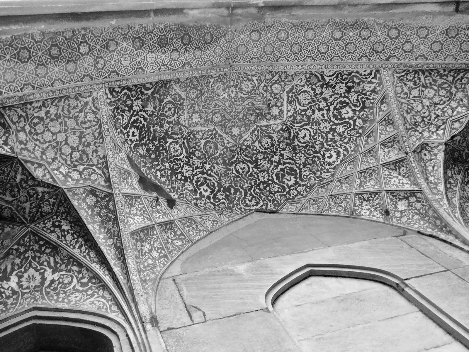
Sgraffito decorations on the inside of the arches of the southern gateway. Sgraffito
is a process where two different colored layers are applied to a
surface, and then patterns are scratched out of the upper layer,
exposing the lower. The very intricate decorations here contrast sharply
with the inlaid stonework on the outside of the building.

A column of simple, yet very striking, inlaid stonework, in a pattern that looks almost tribal.

Akbar's mausoleum, from a distance. One of Agra's most unusual
monuments, the design of the tomb, rather than being focused around the
classic dome of most mausoleums of the period, is instead a series of
five platforms that get steadily smaller the higher they go. Akbar's
body is buried in a chamber underneath the building, though his main
cenotaph is on top of the uppermost platform. The construction of the
mausoleum seems to have been planned out and started in Akbar's
lifetime, though finished during his son Jehangir's rule. The building
is very impressive when viewed from a distance, though one is not
allowed to go up onto the platforms. This is a huge pity, as the most
interesting part of the tomb to see up-close would seem to be the white
marble top level, where Akbar's main cenotaph is located. The whole of
the upper part of the structure is only visible from far away. As one
gets closer, the upper platforms recede, until one doesn't have any real
sense of the overall form of the building.

Closer to the Tomb.

And even closer.

The entrance to the tomb itself. Note that, from this close, the higher platforms are barely visible.

The nearest one can get to a close up view of the fascinating upper
stories of the tomb. The whole design of the building is based around
the oft ignored notion in Islam that one's grave should be exposed to
the elements in order to receive god's blessings. While Akbar's body is
deep underground, he still has a cenotaph, in the middle of a courtyard
on the uppermost platform, which is open to the sky. The top story is
the earliest structure in Agra that I can think which is largely made of
marble. Again, it's a shame one is not allowed up there.

A brightly painted chamber in the tomb, just inside the entrance to the
building. Through the door is a corridor leading to Akbar's burial
chamber. You can just see his grave under the light.

Closer on some of the decorations on the wall.

The way to Akbar's grave. Once you walk through the door to the corridor
leading to the burial chamber, the walls are bare and there are no more
decorations of any sort. It's a creepy place.

Lamp over Akbar's grave. That guy standing behind the grave was in the middle of giving a tour to a bunch of Indian tourists.

The lamp above Akbar's grave.

Looking from the lobby of the tomb, back towards the south gate, through a jali screen.

The fantastic western false "gateway" to the tomb complex. Here, the
decorations consist of inlaid stonework, paintings, and low relief
carvings. According to Lucy Peck, the upper rooms of the building served
as lodging. The main purpose of this building seems to have been simply
visual. The true western gateway to the complex in nearby, though it is
small and unspectacular. Of the three false "gates" of the complex,
this one is in the best condition.

Looking up at the top of the truly spectacular Iwan of the western "gate." Those black things hanging down are gigantic bees nests.

One of the sides of the eastern "gate."

Every surface is profusely decorated.

Inside one of the small rooms at the back of the "gate." The ceiling
here was clearly once extensively painted, though the paint has since
mostly faded away.

The crumbling north "gate" of the tomb complex. Of the three false
gates, this one is the largest, though also the most ruinous. Why the
condition of the eastern and western "gateways" is so much better is
hard to say. The whole northern part of the complex seems to receive
very little upkeep. The area is badly overgrown. It makes one wonder
exactly how much restoration has taken place on the other "gates." The
weed-choked remnants of a walkway lead out the ruins pictured above,
though when I tried to get closer, a security guard came after me and
prevented me from proceeding. Another pity. The northern gate appears to
have once been similar in size to the south gate. It also includes two
floors once used as lodging. Note the remnants of carved Chini Khana decorations on the inside of the Iwan. Chini Khana refers to a style of decoration, prevalent during Jehangir's time, usually depicting vases inside of ornate niches. The Iwan here
is much wider than that of the western "gateway," and the style of
decoration is quite different, being mostly carvings rather than
paintings.
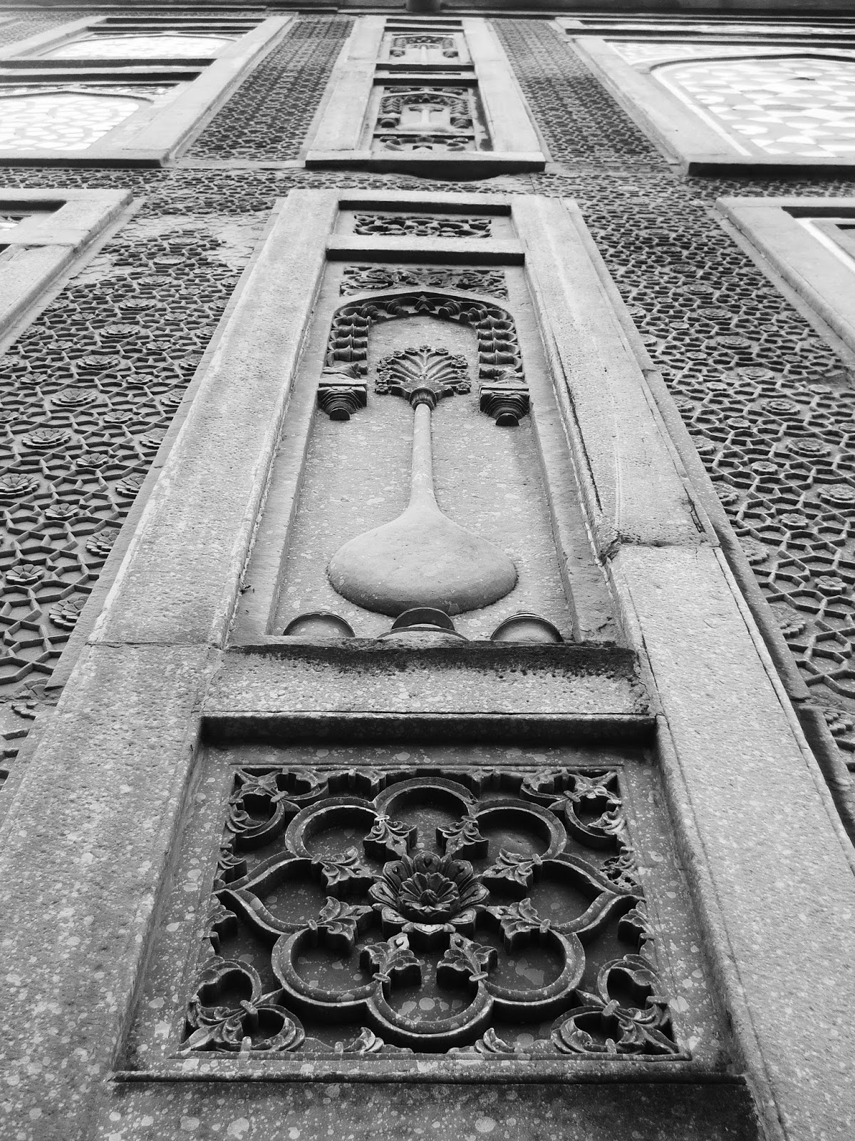
Chini Khana carvings on the eastern "gate." This is a different
angle on the same carvings that appear at the top of this post. The
eastern "gate" is fairly similar to the western "gate," the main
difference being that, though it once seems to have had paintings on the
inside of its Iwan, these have since faded away.

The picturesquely dilapidated mosque of Bhuri Khan. This is in a cluster
of very obscure, rapidly decaying ruins east of Akbar's Tomb, in an
area of newly built high rises and housing projects. I'm fairly sure
that this is the only picture of this building online. The information
available on the structure is limited. It seems to date from the early
to mid Mughal period. I have no idea who Bhuri Khan was. If you look
this building up on Google, the only reference you get to it is a brief
paragraph in an Archaeological Survey of India report from 1874.

An unnamed, disintegrating, tomb north of Bhuri Khan's mosque. In Lucy
Peck's book, which is copyrighted 2008, she describes this tomb as
being in the middle of scrub land. Now it's in the middle of a giant
construction site, surrounded by very new, shoddily constructed looking
apartment buildings. It's actually a fairly dodgy place to visit. When I
wandered in here, the area was full of construction workers obviously
from rural areas of U.P. or Bihar. None of them spoke a word of English,
and they were really surprised to see me. After a couple minutes, the
whole lot of them started simultaneous begging from me and calling me a
behenchod (which isn't a nice thing to say....don't make me go into
detail), so I beat a hasty retreat. Other than that it's probably mid to
late Mughal, I have no information whatsoever on this tomb, not even a
name. This is the only picture of it online, and may in fact be the only
picture of it that will ever be online: I got the impression that this
building was probably about to get knocked down, either to clear space
or on accident. It's in such bad condition, it looks like if that bird
in the upper left hand corned landed on it, the whole thing would fall
to bits.
A chamber under the unnamed tomb being used as a cow shed. This is
probably where the body of whose ever tomb this is was kept. Creepy.
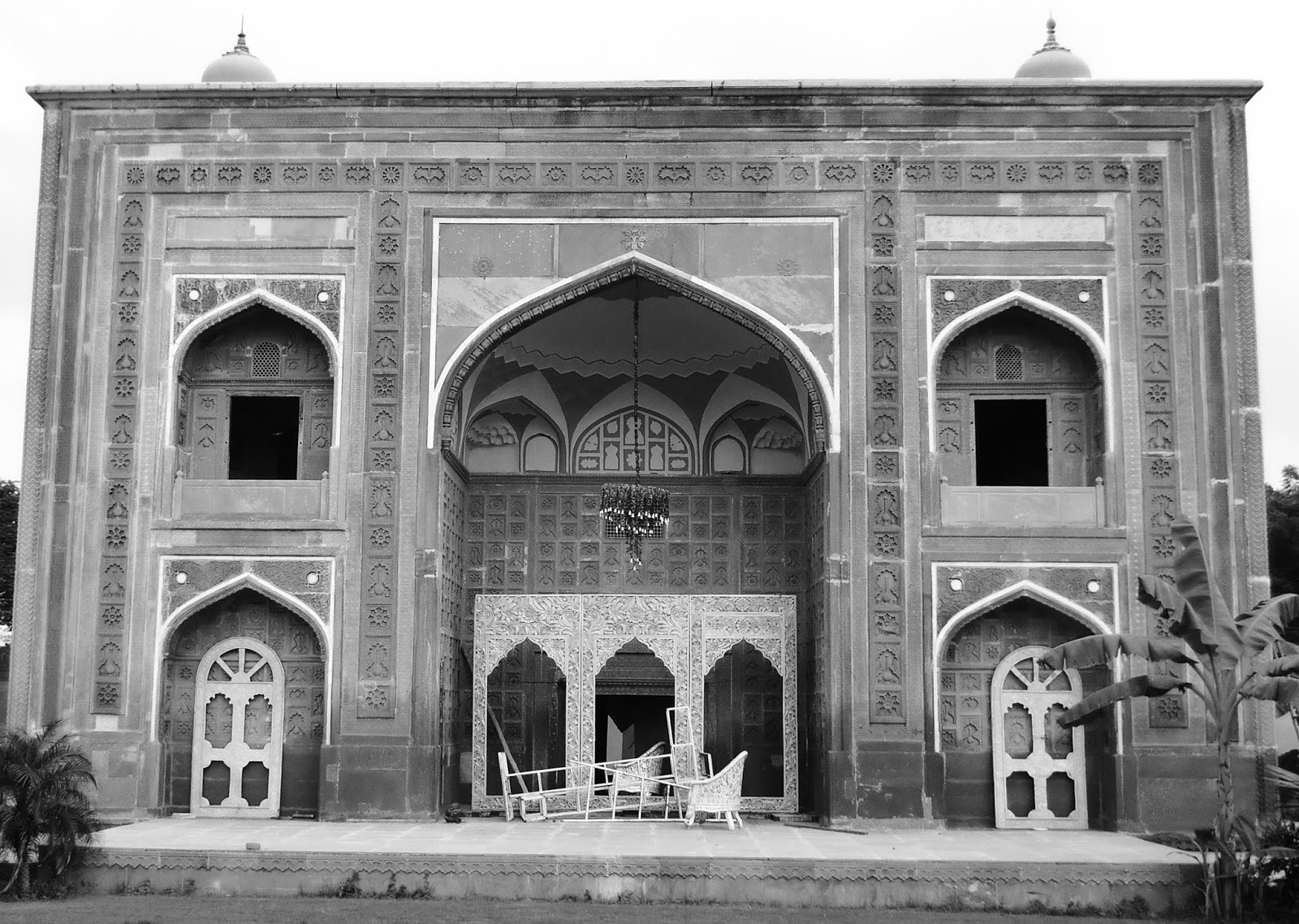
The excellent Suraj Bhan gateway, a little over a kilometer east of
Akbar's Tomb. This building has had an odd career. It appears to have
once been a garden gateway, and it probably dates to Jehangir's reign.
In Lucy Peck's book, and in the few sources that have anything to say
about it online, the gateway is described as being locked away in an
enclosure, decaying and uncared for. But when I visited, the building
appeared to be under private ownership, and was in the process of being
converted into a wedding hall. I'm sure there's a shady story there, as
the building is quite an impressive piece of history and should belong
to the Archaeological Survey of India. I don't think I was supposed to
barge in and investigate the building the way I did, but no one stopped
me.

Extensive Chini Khana carvings on the inside of the Suraj Bhan gateway.

The gateway to the Pachin Mandir, next to the Suraj Bhan gateway.
Judging solely by the style of architecture, I would say it's from the
mid to late 19th century.
In spite of the annoyance of not being able to climb on top of the tomb,
Akbar's mausoleum complex remains one of India's greatest historical
sites. That it is not better known would seem to be yet another
manifestation of the Taj-centrism which effects all aspects of tourism
in Agra. While the Taj is obviously the more beautiful building, Akbar's
tomb is interesting in totally different ways, and deserves to be
treated as destination in its own right rather than just a side trip on
the way to Mumtaz Mahal's mausoleum.
There are other monuments in Sikandra that I did not see, though I fear
most of these are obscure and probably in exceedingly poor condition.
Like so much of India's heritage, these structures won't be with us much
longer. The whole area is in the process of being swallowed up by giant
building projects, which will undoubtedly sweep away large swaths of
history, leaving only a few of the most prominent structures to future
generations.
To sum all this up, I highly recommend, if you find yourself in Agra, to
take a trip to Sikandra, and give yourself the time to visit it
properly.

Some of the heard of Black Buck who live in the garden inside the tomb enclosure.
Agra 5: Not Getting to Firoz Khan's Tomb

Hot action and glamour. Bizarre poster for some American Z grade western
that was being shown dubbed into Hindi at local cinema halls in Agra.
Don't ask me how the distributors got their hands on this undoubtedly
classic film.
South of Agra, on the road that leads towards Gwalior, is the tomb of
Firoz Khan, and I have never been there. My abortive attempt at visiting
the tomb, quite unexpectedly, turned into the most genuine adventure I
had during my time in Agra, and while I wound up with absolutely no nice
pictures from my strange misadventure, it was still very much
experience worth having.
The identity of Firoz Khan is somewhat murky, though most sources claim
that he was the caretaker of Shah Jahan's Harem, who died in 1647. His
tomb, which lies about 5 Km south of Agra, is by most accounts quite
grand and more than worth a look, though, as I was to find out the day
that I tried, virtually nobody goes there.
It was the afternoon after I had gone to Sikandra. The weather had
cleared, and it was turning into rather a splendid late afternoon. I had
an auto drop me off at the intersection of the road to Gwalior with one
of the main roads inside the city. From there, I started walking
south, through the fringes of Agra, where the city begins to slowly
peter out into the countryside. The weather was good for walking, so I
thought I would go several kilometers before I started asking random
passers by where the tomb was.
It's funny in India just how quickly one can go from a place that's
completely dominated by the foreign tourist trade to places where
non-Indians are a rare and exotic sight. Despite being only ten or
fifteen minutes from the Taj Mahal, one of the world's foremost tourist
attractions, where I was now was a place that clearly does not see
foreigners. People started giving me the classic, "What the hell is he
doing here?" look, which is neither friendly or unfriendly, just sort of
a mixture of curious and confused. I knew I was well off the beaten
path.
After walking for maybe thirty minutes, I started asking people going
about their business where the tomb was, and immediately I knew I was in
trouble. I seem to recall going up to about ten different people, from
cops to fruit sellers to teenagers playing cricket, and none of them
knew what I was going on about when I brought up "Firoz Khan's Tomb," or
"Firoz Khan Ki Maqbara." "Firoz Khan ki Maqbara Kahan hai?" mostly got
head scratching and directions to the Taj. Still, it was worth noting
that unlike in the area just south of the Taj Mahal where all of the
backpackers stay, here, as a foreigner, I could actually have a
conversation with random people on the street and not have it devolve
into some sort of ridiculous scheme to wheedle money out of me....one of
the pluses of getting out into less frequented areas.
I wandered around in circles for quite a while, unsuccessfully trying to
get some sort of bearing towards the tomb (and entertaining the
locals), and was starting to wonder if the tomb hadn't been torn down
and replaced by a high-rise or something, when a cycle rickshaw guy came
up to me and asked me where I was trying to get. I explained to him
about the tomb, and then he looked at me with a bemused expression, and
explained to me that he lived nearby. He then offered to take me there,
and I accepted the offer. Poor fellow didn't know what he was in for.
The rickshaw wallah took me west of the road, into an area of poor,
though obviously very new, houses probably belonging to people who had
recently moved in from the countryside. The roads were dirt and in very
poor condition, and the area was very much unlike what had been
described in my guidebook, which gives one the impression that the
immediate vicinity around Firoz Khan's Tomb is fairly open (though maybe
that's my mistake and not the guidebook's...or maybe the area's changed
drastically in the past few years).
As the two of us bumped down the tangle of dirt roads, being regarded
suspiciously by the locals, I started pondering whether the rickshaw
wallah wasn't pulling some odd, convoluted, and very labor intensive
trick. The neighborhood was getting worse, and the roads so rough that
the rickshaw wallah couldn't pull me any faster than I could walk. Then I
saw, off in the distance, the dome of the tomb rising above some very
ad-hoc looking housing.
The rickshaw turned a corner, and ahead of me I saw a large red sandstone gate, very elaborately decorated with Chini Khana,
and in good condition. But as the rickshaw pulled up, people of all
ages started emerging from their houses and gawking at me, and a loud
and spirited conversation (which everybody assumed I couldn't
understand) ensued as to what possibly could have brought me there. The
rickshaw wallah informed everybody that I had come to see the tomb, at
which point the crowd, which must have numbered at least thirty
(including children, who made up about 60-70%), started loudly
discussing something which I couldn't follow.
Not quite sure what to make of the weird scene, I wandered off towards
the gate, and saw that it was locked. Now, this is not atypical of
India's more obscure monuments: One sometimes has to hunt down the chowkidar or groundskeeper, to open up places like this, and it's par for the course that they'll expect a small tip.
I went back towards the crowd, saying "chabiya?" (keys), and making an opening a lock gesture. After some more discussion that involved the word's chabi and chowkidar and Darwaza kolo (open the door), an old surly looking fellow emerged from the crowd.
"Locked, hai, locked," he informed he.
"Haan, toe, app chowkidar hai?" (are you the chowkidar?)I responded in my broken Hindi.
"Haan,"
"Toe, aap key pass chabiya?" (do you have the keys?)
"Nahi." (no).
This rather took me aback....the groundskeeper's job is to have the
keys..that's why the Archaeological Survey of India pays him...
"Toe...eh...chabiya kahan hai?" (so....where are the keys?)
"Yahan nahi." (not here)
"Yes, I know that, but....kahan hai?"
"Tourism Office."
"Tourism Office Kahan hai?" (where is the tourism office?)
"Agra mein." (in Agra)
"Toe...kyun chabiya app key pass nahi hai?" (so...why are'nt the keys with you?)
"Tourism Office."
"Kya?"
"Tum Tourism Office jao." (Go to the tourism office.)
"Leiken...kyun chabiya app kay pass nahi hai? Agra paanch kilometer
door. Yeh....shit!" (why aren't the keys with you? Agra's five
kilometers away. This....shit!)
The surely fellow now crossed his arms and got silent and even more
surely. I pressed him a few more times, but he had decided not to talk
to me anymore. He withdrew into the crowd, who were still all chatting
with one another, though I could see him looking at me and talking about
me, with the occasional "behen chod" (I refuse to translate) rising up out of the conversation. I really wasn't sure what exactly I had done wrong.
I explained to the rickshaw wallah that I would be happy to pay the
chowkidar to let me in. But the rickshaw wallah only reiterated that I'd
have to go to the tourism office, while the chowkidar turned around and
walked away.
The whole sequence of events had been quite strange, and I thought then
that maybe the best course of action would be to go back to my hotel and
cut my losses...but then, I thought, what the hell else did I have to
do that afternoon?
The rickshaw wallah had already offered to take me to the tourism
office, so I thought I might as well take him up on it. I had expended
far to much energy by this point to not see the damn tomb.
Though, as I was riding the five kilometers back into Agra, being pulled
in and out of traffic, something occurred to me: Why would the key be
at the tourism office? The site is administered by the Archaeological
Survey of India, and the chowkidar was ostensibly in their employ. But
government tourism offices are run by a different agency. They might
have been able to contact the A.S.I., but they probably wouldn't have
the keys there at the office.
Getting back into town, the rickshaw wallah pulled up next to the office
and waited. I told him he could go, but he was having none of it: I
think by this point he had spent so much time trying to get me to the
tomb that he was expecting a pretty big reward for his efforts.
I walked into the office, which was a fairly typical affair with some
maps of Agra and posters of the Taj. There were a couple of "Tourism
Officers" there, sitting around looking a little bored.
I went up to a lady behind a desk and told her that I had tried to go
into Firoz Khan's Tomb, but the chowkidar had told me that I had to come
here to get the key....whereupon the lady behind the desk looked at me
like I was crazy. She called over a male subordinate to help figure out
what the hell I was going on about.
The next ten minutes were taken up, not with deliberations on the
location of the keys, which I knew instantly were not in the possession
of the tourism office, but with me trying to explain to the tourism
officers what the tomb of Feroz Khan was, and where it was located.
Though these were people assigned by the government to promote tourism
in Agra, none of them had heard of the building.
For a while, the tourism officers went down the list of major monuments
in Agra, and after exhausting all of those possibilities, produced a map
and asked me to point the tomb out...except it wasn't on it. Finally, I
told them that the rickshaw wallah knew where it was, and that if I
could just get my hands on the keys, then he could take me and it would
be fine. But the tourism officers informed me that, if the keys were not
with the chowkidar, the only other place they would be would be in the
Archaeological Survey of India office...which was closed...
The topic of conversation now swung towards the chowkidar. The male
tourism officer, who was doing most of the talking by this point, seemed
to be just as perplexed by the chowkidar's behavior as I was. It was
weird that he didn't have the keys, and even weirder that he sent me to
the tourism office to get them.
I had by this point accepted that I wasn't going to get to see the 17th
century tomb, but the tourism officer was getting indignant. It was the
chowkidar's job to let people into the tomb, you see, and the government
was paying him for it.
Now the afternoon took another unexpected turn: The lady behind the desk
ordered her subordinate to go to the tomb and get to the bottom of
things, and I was requested to come along, and then file an official
report on the problems I had encountered...who exactly the report would
go to was a question I never got a coherent answer to.
The tourism officer and I emerged from the building. The rickshaw wallah
was still waiting outside, though now that he saw that he was going to
be pulling along an extra person back down to the tomb, he looked less
than happy to see me.
We set off, and I found myself travelling along the same five Km stretch
of road for the third time that afternoon. I talked a bit with the
tourism officer, who seemed like a swell guy, though he had only been
posted to Agra a few weeks before and didn't really know the place too
well. He appeared to regard the whole affair with a mix of anger and
embarrassment: Justifiably, he was pissed that the chowkidar wasn't
doing his job, but I think he also felt that the episode reflected badly
on India as a whole.
The three of us (the rickshaw wallah, the tourism officer, and me)
eventually arrived back at the gate to the tomb, though if the locals
had been shocked to see me the first time, they were even more so the
second time around. A crowd formed instantly around us, and I recognized
most of the people from before, though the chowkidar was conspicuously
absent. The rickshaw stopped, and the tourism officer got off and
immediately addressed the locals.
He started demanding that they tell him where the chowkidar was, and
when nobody gave him a straight answer, the conversation devolved into a
shouting match, with all twenty locals against the tourism officer, and
the locals coming off second best.
As far as I could tell, the tourism officer was making legal threats
against chowkidar, and the chowkidar's family and relations were trying
to make excuses for him. But the tourism officer was having none of
this, and in short order his threats were getting the locals genuinely
scared. Soon the whole crowd of them started furiously arguing
simultaneously with the tourism officer and with each-other over what
they should do. Insults went flying in every direction. I have no idea
what the Tourism Officer was specifically threatening the locals with,
but it was enough to get the whole neighborhood worried, desperate, and
pissed off.
Standing back near the entrance of the tomb, no longer the center of
attention, I marveled at what I had started. My attempt to visit the
17th century tomb had shook up the entire locality. It had certainly not
been my intention to ruin anybody's day, though it did seem, even if I
couldn't understand the exact circumstances, that the chowkidar had it
coming.
Yet, for all his efforts, the tourism officer couldn't get the chowkidar
to appear. He had managed to wrest the man's phone number from the
crowd, but the chowkidar wasn't picking up. After a final round of
threats, the tourism officer decided that it was time to leave the
field of battle. The two of us got back on the cycle rickshaw (the
rickshaw wallah by this point looking thoroughly sick of the whole
affair) and started to ride off.
But as we tried to leave the neighborhood, several ladies (don't ask me
why each one was a lady) approached us, and came up to talk to the
tourism officer, all in rather shady, hushed tones of voice. The
impression I got was that they were trying to make him some sort of
offer, perhaps a bribe, though when I asked him about it, he said they
were "Just making excuses and shifting blame." They were apparently
ratting other people in the neighborhood out, and, according to the
tourism officer (who, for all his righteousness and indignation, was
perhaps not a totally reliable source), trying to make it seem like
other people were responsible for the chowkidar's failure to be present
with keys.
Now we rode back, for the fourth and final time along the five km
stretch north to Agra. I tried to get out of the tourism officer why the
chowkidar had not had the keys, and indeed why the episode had created
such a giant stink, but there was clearly something the man didn't want
to tell me. For his part, he made no attempt to hide his embarrassment
and disgust, and between almost uncomfortably profuse apologies at my
not getting to see the tomb, went into lengthy disquisitions on the
moral decline of Indian society, brought about, according to him, by a
mixture of easy money, T.V., porn, bad politicians, holy men, and just
plain laziness.
He went on to say that, if I wished to see the tomb, I could come with
him the next morning, when, theoretically, the keys would be
obtainable.
"But there's no need," he said.
Why's that?"
"It's totally wrecked. Ruined. This is not a proud monument."
"Totally wrecked?"
"That is how they treat their heritage...they don't care for historical buildings. It is totally destroyed!"
This was a very odd attitude on the tourism officer's part. Yes, the
locals had certainly been behaving badly, and the locale left much to be
desired, but the tomb itself, as nearly as I could see, was in really
fairly good, or at least not appallingly bad, condition. I had seen
historic buildings in vastly more desperate shape just earlier that day
when I went to Sikandra.
It seemed then that the tourism officer's anger at the way the locals
had been behaving sadly blinded him to the fact that the tomb was still
something worth seeing, and a possible tourist site, if only the
Archaeological Survey of India would have the intelligence and foresight
to open the damn thing up. Though I was certainly on the man's side as
far as the chowkidar was concerned, and though the man had really gone
very far out of his way, in part at least, for my benefit, the fact that
he saw the tomb as "totally destroyed," worried me.
The truth is, the vast majority of the historical buildings in India are
under some sort of pressure. All one needs to do is take a twenty
minute walk in the back lanes of Old Delhi to see dozens of old and
interesting structures which are in rough neighborhoods and deplorable
condition. Yet the fact that these structures are under such threat is
precisely why they should be taken notice of. If simply being in a
difficult location made a historical site not worth bothering with, then
it would make sense to simply do away with the larger part of India's
architectural heritage.
Yet again, the three of us wound up back at the tourism office, where I
filled out my report. I had to write (in my atrocious handwriting),
about a page long account of my experiences trying to reach Firoz Khan's
Tomb, while both the lady behind the desk and the tourism officer were
very particular that I should make it abundantly clear that I "was very
disappointed"...which actually I wasn't, in the final analysis: Though I
hadn't made it to the tomb, the day had turned out vastly more
interesting than I had thought it would. And who knows? Maybe the report
actually made a difference. At least one thing that I can be sure of is
that the good folks at the Agra tourism office now definitely know
where Firoz Khan's tomb is.
I bid farewell to the tourism officer, and asked, as politely as
possible, if the rickshaw wallah would drop me back at the hotel. He was
willing, and since he had gone so far above and beyond the call of duty
that day, I gave him a big tip.
Agra 6: The Old City

A late 19th or early 20th century courtyard, somewhere deep in Agra's fascinating old city.
As odd as it may sound, there is a vast and deeply historical part of
Agra, India's most heavily touristed city, which is almost entirely
ignored by outsiders. This is The Old City, the bustling, incredibly
intense, impenetrable seeming region of Agra north of the Red Fort and
west of the Yamuna. Here, beginning in the 16th and 17th centuries, were
the great mansions of the Mughal elite and the business communities
which profited from the Mughal court's ridiculous expenditures (which
apparently largely drove the economy of the entire empire.)
As the Mughals went into decline, so to did the city, and most of the
great mansions slowly fell into ruin and were abandoned. Still, the city
remained a major trading center, and went though something of an
economic resurgence in the 19th century under colonial rule.
In the 21st century, Agra's Old City is a huge and confusing
anachronism. It's a place where the 21st century is desperately trying
to establish itself and is so far failing miserably. While the grand
Mughal mansions have (mostly) long since crumbled into oblivion, smaller
buildings from latter centuries have sprung up among the ruins,
frequently oriented around the plan of the older buildings. And so,
while there may not be any extant physical remnants of the Mughal
mansions, their imprints, in the form of the layouts of many of the
neighborhoods within the city, remain.
The Old City is now incredibly congested. Thousands of cars and trucks
and auto-rickshaws and motorbikes sharing limited space on streets laid
down before the combustion engine was even invented leads to terrible
traffic. The city is not easy to explore, and yet, of all the places in
Agra, it is perhaps the most rewarding to spend time in. Around every
corner there's something interesting, and something very few visitors
ever clap eyes on. Yet, unlike the Taj, or Agra Fort, or Sikandra, the
Old City is not a museum: It's a place where communities in Agra have
lived and worked since before the Mughal period, giving the area an
unbroken connection with the past.
As such, I highly recommended visiting. Even more so when one considers
that many of the buildings in the photographs below might not exist in a
few years time. Also, at least in my experience, other than plenty of
staring (that's if you're a conspicuous white foreigner!), I encountered
almost no typical Agra type tourist hassles (as in, pushy guides,
touts, hawkers, etc. etc.) There seems to be very little in the way of
conservation work being done in the Old City, which is refreshing in a
way (nothing destroys a monument quicker than a shoddy restoration job),
but it also shows that nobody really seems to care that much about the
area in terms of its historical value.
Much of my information comes, again, from Lucy Peck's comprehensive Agra: The Architectural Heritage, though
even the details provided there are limited. I visited twice, on two
longish walks, though obviously the city still contains plenty of sights
that I did not see.

The Agra Jama Masjid, the Old City's most prominent building. Some
sources say it was commissioned by Shah Jahan and dedicated to his
daughter Jahanara, while others claim it was Jahanara herself who built
it. The mosque was once directly linked to the Delhi Gate of Agra Fort
via a large market area, though that was obliterated by the British when
they ran a rail line through in the 19th century. The British also
destroyed the mosque's front gate during the Sepoy Uprising, creating an
awkward arrangement where the courtyard of the mosque opens almost
directly onto the street. You'll notice that the domes above the mosque
seem to be receding behind the building. They were built without drums,
and hence don't stand out as much from the rest of the structure as do
the domes on most other Mughal buildings. I haven't been able to figure
out what happened to the missing minaret above the prayer hall.

The primary mihrab of the mosque, along with people sitting out the heat
of the day. I was there at around 3 P.M., after afternoon prayers, and
the whole place was fairly quiet. Local Muslims using the prayer halls
in mosques to hang out in the afternoon is a common sight in India.

Perhaps the most striking architectural feature of the mosque are the long lines of chhatris lining
either side of the courtyard, seen here. The people at the left of the
photo are part of a small madrasa that's run inside of the mosque.

This is a typical crazy alley in the bazaars north of the Jama Masjid.
They seem to be selling everything here from toys to food to jewelry.

A gigantic number of cheap toy guns. There was in a small alley which sold absolutely nothing but these "Baby Toy Pistols."

What I think is a temple gateway on Peepal Mandi road, probably from the
19th century. In front is a bike repair shop, a fruit seller, and a man
selling funny hats on a stick.

A funny hat seller.

That's what the funny hats do...you blow on a little tube and the
tassels fly out. They also make an undignified noise. I had to follow
this guy around for a little while to catch him at it. I think the
person staring at the camera to the left thought I was strange. In the
background is the Jama Masjid.

Traditional doorway and balcony on a street called Rawat Pada. Note the wood carved figure on the lower right side of the door.

An unusual, probably late 19th century balcony in Rawat Pada, with music playing figures carved into pillars.

Street selling religious paraphernalia. Rawat Pada.

A traditional balcony, and peeking monkey, above shops.

Traditional 19th century housing being swallowed up by 21st century commercialism.

Dilapidated 19th century housing above a cooking ware shop.

An interesting Art-Deco building, and monkey, in the middle of rather a
shady alley. Just as it did in the west, Art Deco made a fairly strong
impression in India during the 20s and 30s, and in many older parts of
Indian cities, the last truly interesting buildings come from that
period.

A typical, crumbling, back alley, along with eccentric electrical
arrangements. Judging by the slab of red sandstone visible in the side
of the building to the left, and some of the other structures in the
immediate vicinity, parts of these buildings probably go back quite some
time.

This building, partially obscured by electrical wires, appears to be
from rather earlier than most of the surviving historical structures in
the city. Stylistically, it looks like it could very well date from the
18th or 17th centuries.

Small balcony above the street. I was told, admittedly by several drunk
fellows, that this was a "thousands years old" temple...It may be a
temple, but it's probably not a thousand years old.

An unexpected art galley under the railway tracks.

A very large, interesting gateway deep in the Old City, along with plenty of motorbike traffic.

Looking south along Kinari Bazaar Road, one of the the main drags of the
old city. The red sandstone building to the left is the Akbari Masjid,
which is old enough to have needed a major restoration job in the
nineteenth century.

Vat Jewelers "Finest Showroom of Imitation Jewelry." A truly bizarre,
stylistically mutant, facade at an intersection just north of the Akbari
Masjid, probably from the early 20th century.

Another bizarre early 20th century facade on Kinari Bazaar road, with a mixture of indigenous and Art Deco elements.

Perhaps the most striking structure on Kinari Bazaar road, if memory
serves, opposite the Vat Jewelers building. The lower balcony is clearly
significantly older than the upper, which may be late 19th or early
20th century.

Looking straight up at the lower balcony.

Big wedding-light-flower-cart-thing....I have no idea what these are
called but I happened across a garage full of them....along with two
guys having an argument....

A 19th century gateway, which was obviously once the entrance to a large enclosure, on Kashmiri Bazaar Road.

Looking back out through the same gateway onto the electrical chaos outside.

An Old City gun shop.

A small, silver-painted 19th century Vishnu Temple.

A minaret of the Motamid Khan Masjid, on Kashmiri Bazaar Road, one of
the few genuine Mughal buildings in the city, dating from the 17th
century. Note the Chini Khana decorations on the lower part of the minaret.

Another fragment of a genuine Mughal building called the Kala Mahal, a
very large, Jehangir period haveli, built for Raja Gaj Singh of Jodhpur.
The haveli has largely disappeared, the only surviving remnants being
two small turrets, which themselves seem to be well on their way to
oblivion. This one is fast disappearing under advertisements for an
Akshay Kumar film from 2004 called "Aan: Men at work," which Wikipedia
states is "about the life of a police officer fighting crime
constantly." An odd fate for the last vestiges of a 17th century Mughal
mansion. From what I've seen, in various Old Cities in India, the
turrets, towers, or minarets, at the corners of historical buildings are
frequently the last things to get obliterated.

A rather better preserved Mughal corner turret, this one from a garden
which has since been filled in with development. This area, where the
old city butts up against the Yamuna, was apparently once lined with
gardens, all of which have over the centuries disappeared.

A tower of the Mubarak Manzil, an Aurangzeb period building in the
Belanganj area of the Old City, of which, again, very little of the
original building survives but the corner towers (for example, those air
conditioning units to the right of the tower were not part of the
original Mughal conception!). The building was the headquarters of the
Colonial Customs House for a while. It has a fairly incredible gateway
on the south side, though at the time I visited this was unfortunately
partially hidden by another, modern, metallic gateway.

A large, interesting haveli. This is in the northeast part of the old
city, in an area called Belanganj, which was where the most successful
merchants in colonial Agra had their houses.

Closer on one of the corners of the facade of the Belanganj haveli.

Another large haveli gateway, with a guy carrying a big bag through it.

Haveli gateway detail.

Haveli gateway.

An interesting, probably late 19th century house.

A haveli gateway partially obscured by potato sellers. In the old city,
no effort is made towards making the interesting old buildings visible,
and often just getting a photo of the damn things means risking life and
limb in crazy traffic.

An ornate wooden balcony. The top panels of the left and right windows
have carvings in the shape of Gujarati style struts, as seen in Akbari
period architecture.

Mata Ka Jagran, and mother goddess. I bumped into a large procession
with numerous eclectic floats on my way back out of the Old City the
second time I visited. Mata Ka Jagran, which is what it says at the top
of the sign, is a form of all night worship...though here it seemed to
manifest itself as a large party and parade...

"Bebsite.www.Mughalfireworks.com"

The domes of the Jama Masjid over the city.

The Jama Masjid at dusk, from the stairs that lead up to the old railway station, between the mosque and Agra Fort.

Jama Masjid evening silhouette.
While most places one visits in Agra are very controlled environments,
the Old City is just the opposite. Going there is a genuine adventure,
world's apart from a dawn visit to the well manicured gardens of the
Taj, but one well worth having.

I knew the Old City was old, but I didn't realize it was that old.
Agra 7: Itimad-ud-Daulah's Tomb and Chini ka Rauza

The top of the fantastic tomb of Itimad-ud-Daulah, in the very first direct sunlight of the day.
Along the east bank of the Yamuna, across from the Taj, Agra Fort, and
the Old City, are the remnants of a long series of Mughal gardens and
tomb enclosures. I had hoped, on my last morning in Agra, to take a long
walk along the entire riverfront and see most of these, though I wound
up pressed for time and was forced to only visit a couple of the
highlights: The spectacular tomb of Itimad-Ud-Daulah, and the
interesting and unique Chini ka Rauza, or China Tomb.
Itimad-ud-Daulah's tomb was built by Nur Jahan, empress of Jehangir and
the most powerful woman of the Mughal era, for her father Mirza Ghiyas
Beg. A talented administrator of Persian origin, Ghiyas Beg rose to the
rank of prime minister, and was bestowed with the moniker
"Itimad-ud-Daulah" which means "Pillar of the State."
The man himself is perhaps better remembered for his descendants than
for his own achievements. His daughter, as Jehangir's twentieth and
favorite wife, is often described as the power behind the throne in the
latter part of Jehangir's reign, due to the emperor's ever increasing
love of opium and alcohol. As the emperor's closest confidant, at a time
when the Mughal ruler possessed near absolute power, she was in a
position to influence the entire course of the empire. It was only upon
Jehangir's death that her position was undermined, as she backed the
wrong side in the succession struggle which followed, running afoul of
Shah Jahan. Still, she was given a luxurious confinement after Shah
Jahan secured the throne, during which she built Ghiyas Beg's Tomb.
Ghiyas Beg was also grandfather of Mumtaz Mahal, the woman who inspired
and is buried in the Taj, via another one of his daughters. He was
therefore the great grandfather of the emperor Aurangzeb, who ruled over
the empire at its greatest extent, and witnessed the beginning of its
decline.
His tomb is interesting from an architectural standpoint because it
marks the start of the shift from the very eclectic, stylistically mixed
buildings of Akbar's time, to the more restrained, persianized
structures of Shah Jahan's. The mausoleum is also, famously, one of the
first major Mughal buildings to be largely constructed out of white
marble. This has led to the tomb being called the "baby Taj," and being
often viewed as a model for the more famous mausoleum. This comparison
is rather unfortunate: Other than the use of white marble, the tomb of
Itimad-ud-Daulah is very much unlike the Taj, and deserves to be seen in
the light of its own merits and not merely as a stepping stone to the
other building.
Though the mausoleum is far from obscure, it draws nothing like the vast
crowds that flock to the Taj. I visited it right after dawn and spent
nearly forty five minutes at the site taking photos in the rapidly
changing lighting conditions. It wasn't until I was leaving that other
people began to show up.

The tomb of Itimad-ud-Daulah at dawn.

The Tomb

A view on the side of the tomb. The most striking feature of the
mausoleum is its incredible inlay work. All of the colored patterns
visible here are fitted stones.

Another view on the incredible inlay work. The technique here is at an
interesting transitional point between the spectacular but simpler
patterns of Akbar's Tomb, and the more intricate peitra dura work of the Taj Mahal. Many sources make the mistake of referring to the technique here as peitra dura (which
literally means "hard stone" and was imported from Europe...hence the
Italian), however this variety of stone inlay work had been known in
India for quite some time.

One of the very fine jali screen windows on the side of the tomb.

One of the minarets.

Close on one of the inlaid stones.

Looking out from the north entrance of the mausoleum, to one of the
false gateways of the tomb enclosure. As with Akbar's tomb compound,
here there is only one "true" gateway through the wall around the tomb,
while the other three serve merely ornamental purposes.

Both the inside and the outside of the tomb are fantastically decorated.
The interior is covered in exquisite paintings, mostly of plants. Note
that, in the center of the picture, above the cenotaph, you can see
through the jali screen window to the east gate of the enclosure. The
grave marker is that of one of Ghiyas Beg's relatives, a large number of
whom are buried in the tomb.

Paintings in the central chamber of the tomb, housing Ghiyas Beg's
grave. The chamber is spectacularly covered in paintings, though
unfortunately the light was not strong enough to get a good picture with
my little camera (I need a new one).

A little later in the day, just as more tourists were arriving. The
speed with which white marble changes color in different lighting never
ceases to amaze.
After leaving the Tomb of Itimad-ud-Daulah, I had just enough time to
walk north and visit a few of the nearby monuments. The most prominent
of these was the Chini ka Rauza, or China Tomb, which is the early 17th
century mausoleum of Mullah Shukrullah Shirazi, a prime minister in Shah
Jahan's court who was also a poet and the brother of the calligrapher
who worked on the outside of the Taj Mahal. His tomb is one of the most
unusual in all of North India. Architecturally it's very simple, even to
the point of being drab, with flat sides, an unusually small dome, and
short minarets. But what stands out are the incredible, if now partially
effaced, panels of blue, green, and black tile work which once covered
the exterior of the tomb. These explain the simplicity of the
architecture: The whole tomb was designed solely around having large
flat spaces on which to display the tile work.

Not far from the almost perfect tomb of Itimad-ud-Daulah is this
neglected, creepy, dilapidated mausoleum. It is the tomb of Prince
Parwiz, one of the brothers of Shah Jahan. Virtually all of the
ornamentation once on the outside of the tomb has been stripped away,
while the inside is being used as a cow shed. As I recall, a couple of
locals had shacks built right next to it.

An excellent corner turret, one of the few architectural remains of a
Mughal garden from Mumtaz Mahel's time called Zahara Bagh. The body of
water to the left of the picture is the sad revolting river of
putrescence that was once the Yamuna. This was taken from the Chini ka
Rauza tomb enclosure.

The north side of the Chini ka Rauza, which has the most surviving tile work.

Tile work on the south side of the tomb.

Plants and geometric designs.

Tile work

Close up on a well preserved tile work plant.

Blue calligraphy.

The interior of the Chini ka Rauza is also richly decorated, though you have to be able to track down the chowkidar to get in. These painting were apparently restored, though not in the last few decades, judging by their current condition.

While the paintings certainly don't look new, and are very impressive in
their own right, it's hard to say how much of them are original. A
photo from the turn of the 20th century shows much less visible painting
than is evident here. Apparently the tomb was used as a residence for a
while, and many of the original paintings were covered in soot from
decades of people building fires inside the mausoleum.

Still, certain parts of the interior decoration, such as the fragment of
plaster under the arch in this picture, probably do date to the 17th
century.

Light coming through the entrance to the tomb.
The tomb of Itimad-ud-Daulah is all too often left out of tourist
itineraries, which is a pity, as it is one of India's most perfect
architectural achievements. The Chini ka Rauza may have seen better
days, but it's still a fascinating place to visit, and, like so many
historical structures in India, deserves better care.
So, this is the end of my series on Agra. The city has its flaws, but a
lack of things to see is not one of them. As fond as I am of Mumtaz
Mahel's mausoleum, there is much more to Agra than the Taj. Spending
only one day, or half a day, in Agra is really not enough time, and I
think that the city as a whole would have a better reputation if
visitors didn't hurry through it.....
.....but that's just me.

Graffity, presumably by a little kid, of a woman sitting in a fish's mouth, on the east side of the Chini ka Rauza.
Meghalaya Monsoon Itinerary

Crossing the Nongthymmai living root
root bridge, the longest of all (known) living root bridges, in the
monsoon season of 2011. Believe it or not, the whole span is made of
rubber tree roots that were trained across that stream over the course
of a few decades by local Khasi villagers, making it one of the world's
most striking examples of biological architecture. During this trip,
we'll be staying in a small village about 45 minutes from here, in a
little visited corner of northeast India that's simply abounding in
fantastic things to see.
MEGHALAYA MONSOON TRIP
Here's some information on an itinerary I'm going to be running twice during this year's monsoon season in the northeast Indian state
of Meghalaya. Meghalaya receives more rainfall than any other place on
the planet, and is home to centuries old living root bridges and one of
India's friendliest and most interesting tribal communities: the Khasis.
It's a place of stunning beauty, of four thousand foot deep, mist
filled canyons, where there's literally a waterfall around every corner,
and where the average day's walk involves crossing raging,
monsoon-swelled torrents over suspension bridges not much wider than
your foot that are strung across rocky chasms......
.....so, this is not an itinerary
for the faint of heart, but I guarantee, visiting the place with the
world's most dramatic weather, and seeing that weather at it's most
dramatic, is an experience that you'll take with you the rest of your
life. Just be ready to get rained on!
Our itinerary will also take in some
of the "Classic" Indian tourists sites, such as the Taj Mahal and the
bustling lanes of Old Delhi, and will give you a truly unique
opportunity to get on and off the beaten path. You'll see the famous
stuff in Delhi and Agra, but also dozens of incredible temples, mosques,
mansions, bazaars, and ruins that most visitors miss. SCROLL DOWN TO THE BOTTOM FOR A SET OF PICTURES OF WHAT WE'LL SEE!
EMAIL ME AT: anselmrogers4@gmail.com if you would like more information or if you would like to reserve a seat.

Surrounded by kids in Delhi. Yes, one thing the North and Northeast
Indian phases of our trip will have in common is hordes of little kids.
DATES:
FOR JUNE: The trip starts on JUNE 13 and ends JUNE 29,
not counting travel to and from Delhi International Airport. In order
to confirm a seat on the June trip, please send me a small deposit (the
exact amount TBA), by MAY 1ST. I'll need the balance by MAY 23.
FOR JULY: The trip starts JULY 18 and ends AUGUST 3,
not counting travel to and from Delhi International Airport. In order
to confirm a seat on the July trip, please send me a small deposit (the
exact amount TBA), by MAY 30. I'll need the balance by JUNE 27.
PRICING:
What I'll need is U.S. 1350, payable through Paypal.
WHAT THAT COVERS: All accommodation. All in-country transport,
including plane tickets, train tickets, metro cards, airport/train
station pickups/drop-offs, auto-rickshaws, cycle-rickshaws. Entree fees
for monuments. Camera fees. Guide charges. Tips. All expenses in the
village of Nongriat.
WHAT THAT DOES NOT COVER: International airfare. Visa/passport
processing. Health/travel insurance. Gifts. Meals in Delhi, Agra,
Cherrapunji (average breakfast cost: 2 U.S., average dinner cost: 3-4
U.S.).
TOTAL ESTIMATED TRIP COST: U.S. 3000 (and much less without presents!).
ITINERARY:
[Note 1: Be advised that India is a
very flexible place, which means that to adapt, we'll also have to be
flexible. Hence, be ready for a few on-the-spot emendations to
this itinerary once we get there...unpredictability is a vital part of
the Indian experience.
Note 2: I've put all the place names in CAPS in case you want to do your own research on these areas.]
Day 1-Landing: Arrive
at New Delhi International Airport. I'll pick you up there, and then
we'll transfer to our hotel in MAJNU KA TILLA, Delhi's center of
Tibetian culture. We'll get settled in, and then get some sleep.
Day 2-Delhi: We'll
start the day with a ride on the Delhi Metro. From JOR BAGH STATION,
we'll take our first auto rickshaw ride to fantastic HUMAYUN'S TOMB,
the mausoleum of the second Mughal Emperor and the direct architectural predecessor of the Taj Mahal.
From there, we'll head to CANNAUGHT
PLACE, and have a meal at a famous South Indian Restaurant called
SARAVANA BHAVAN. After that, we'll take a brief sojourn to Delhi's most
impressive step-well AGRASEN KI BAOLI, and one of it's most bizarre
monuments, the JANTAR MANTAR, which are both within walking distance.
We'll then retreat to the air
conditioned metro before the worst heat of the afternoon sets in, and
spend the middle part of the day resting in our hotel. Those who still
have energy can come back out with me at around 3:30-4 in the afternoon,
and walk to the nearby, though rarely visited (at least by foreign
tourists!) NORTHERN RIDGE, an area of urban jungle with the most monkeys
I've ever seen.
Dinner in one of the many good Tibetan restaurants in MAJNU KA TILLA.
Day 3-Old Delhi: We'll devote
this day to the exploration of Old Delhi, starting with the DELHI RED
FORT. From there, we'll plunge into Old Delhi's fascinating back lanes,
where we'll visit an assortment of old crumbling mansions, numerous
bazaars specializing in everything from silver jewelry to wedding
decorations, along with a number of Jain temples and mosques.
As the heat of midday approaches,
we'll retreat to out hotel for our daily siesta. In the afternoon, we'll
head back out to Old Delhi, and this time visit the GADODIA MARKET,
Asia's largest wholesale spice market. After that, we can do a bit more
sightseeing as we work our way to either KARIM'S or AL JAWAHAR, two
restaurant's which specialize in Mughal food, for dinner.
We'll get back early to MAJNU KA TILLA and get a good night's rest.
Day 4-Delhi to Agra: We'll
get up early and transfer to the NEW DELHI RAILWAY STATION. From here,
we'll take an early morning train to Agra, arriving at around 8:15.
We'll then transfer to our hotel in the TAJ GANJ neighborhood of Agra.
For the rest of the morning, and the
first half of the afternoon, we'll rest up and eat at the
hotel restaurant. Then, in the evening, we'll head out to AGRA FORT.
Dinner at the hotel.
Day 5-Taj Mahal and Sikandra: As
early as possible, we'll wake up and walk from our hotel to the
entrance to the TAJ MAHAL, so we can visit the mausoleum in the
least crowded, coolest, part of the day, under the best lighting
conditions. We'll spend a while wandering about in the tomb complex, and
then come back to our hotel and have lunch.
After our daily siesta, we'll head
out to the environs of Agra, to the tomb of the third, and greatest,
Mughal emperor AKBAR, in SIKANDRA.
Dinner at our hotel.
Day 6-Itimad-Ud Daula-Agra Old City-Delhi: We'll
get up early and visit the fantastic TOMB OF ITIMAD-UD-DAULA and if
we're feeling up to it, the immensely interesting CHINI KA RAUZA. Then
we'll return to out hotel and sit out the hottest part of the day.
Later in the afternoon, we'll head
out to the OLD CITY OF AGRA, a largely ignored maze of mansions,
temples, mosques, and bazaars, which is very much off the radar of the
average tourist itinerary.
Following that, we'll have an early
dinner at our hotel, and then head via train back to Delhi, reaching our
hotel in MAJNU KA TILLA around 11-11:30 PM.
Day 7-Delhi: Anyone
feeling fatigued by Agra will be encouraged to sleep through the morning
on this day. People who are up for it can come with me to South Delhi
to visit the QUTB MINAR, one Delhi's signature buildings, along with one
of India's most important historical complexes.
After lunch and our daily siesta,
we'll head to OLD DELHI once again, but this time we'll make the trek to
one of Delhi's most extraordinary sights: FEROZ SHAH KOTLA, where
thousands of people come and crowd into a 700 year old ruined mosque
to ask favors from disembodied spirits every Thursday.
Our dinner choices are either some relatively upscale restaurant in CONNAUGHT PLACE, or some place in MAJNU KA TILLA.
Day 8 Delhi-Guwahati-Cherrapunji: Travel
Day. We'll get up and take a relatively early flight to GUWAHATI,
leaving the hustle and bustle of North India well behind. Flights range
from two to three and a half hours. From GUWAHATI we'll get picked up by
a four wheel drive vehicle and ride to our hotel, a cozy new backer's
hostel called BY THE WAY in the town of CHERRAPUNJI. The ride should be
between four and five and half hours, depending on weather and traffic
conditions. Dinner in CHERRAPUNJI.
Day 9 Cherrapunji-Nongriat: On
this day, we don't have to get up early! We'll have breakfast in
CHERRAPUNJI, and then transfer to a village called TYRNA, from where
we'll start our 1500 foot hike down through tropical rain forest to
the village of NONGRIAT, our home for the next five nights. On the hike
down we'll cross two exciting wire suspension bridges, and two living
root bridges.
There won't be any rush. We can take our time getting there, and once we get there, we can settle in and relax.
Dinner at NONGRIAT GUEST HOUSE.
Day 10-13 Full days in Nongriat: These
will be our four full days in the village of Nongriat. There's no point
coming up with a comprehensive itinerary for these days, as what we'll
do on each day will depend to some degree on the weather and how
energetic people are feeling.
Still, it's important to note:
1: Most hikes in the area immediately around Nongriat are possible in the rain.
2: There is usually a sunny day every few days in Meghalaya, even in the monsoon season.
3: One of the most rewarding activities in the Nongriat is simply sitting around the village meeting the friendly Khasis.
Activities in and around Nongriat:
1: There are six living root bridges in the immediate vicinity of Nongriat, all of which can be seen in wet weather.
2: There is an additional, partly
ruined, though still very interesting, root bridge, that we can see,
though walking out on it is too dangerous.
3: There are five dramatic
wire suspension bridges (which are composed of steel cables that have
been placed across streams) within ninety minutes walking of Nongriat.
These bridges are perfectly safe, and they give the most spectacular
views of the rain-swelled streams (as in, from a vantage point where
you're suspended directly above them).
4: There is one bridge that is made from both steel wire and roots.
5: There are seven other Khasi
villages within walking distance of Nongriat. Most of these see far
fewer foreign visitors than Nongriat, and are worthwhile day
hiking destinations in and of themselves. They are NONGTHYMMAI, MYNTENG,
RAMDAI, PYNEM DKHAR, MAWLAKHIAT, MAUSAHEW, and TYNDRONG. The trails
between these villages have many of the most spectacular viewpoints in
the area.
6: There is another living root
bridge in the vicinity of the village of TYNDRONG, which is
the remotest village in the area. I am reasonably sure that I am the
only outsider who has ever documented this bridge. The hike to it is one
of the best hikes in the area.
7: While swimming in the larger streams during the monsoon season is ABSOLUTELY NOT ADVISED (!!!!!!) there are a number of smaller water bodies where it will still be possible to take a dip and wash clothes.
8: It will be possible to go out for
short hikes after nightfall, on the wide, safe, concrete trails near
Nongriat. All sorts of interesting animals are more active during the
night, including civets, several varieties of crabs, various amphibians,
and numerous insects, including a number of species of huge stick
insects.
Day 14 Nongriat-Cherrapunji: On this day we'll hike back up out of Nongriat, return to "BY THE WAY" in Cherrapunji, and take the afternoon and evening easy.
Dinner in Cherrapunji.
Day 15 Cherrapunji-Delhi: We'll
get up bright and early, ride to the GUWAHATI AIRPORT, fly back to
Delhi, transfer to our hotel in MAJNU KA TILLA, and have dinner.
Day 16 Delhi: I'm keeping
this day free. If there was something else in Delhi that we missed
earlier in the trip, we can see it on this day. Also, we can start
shopping for presents and souvenirs.
Day 17 Delhi-End of Itinerary: The
morning through early afternoon are free. More shopping, or perhaps a
visit to a sight in Delhi. Transfer to onward destination.
PHYSICAL LEVEL:
This trip WILL INVOLVE QUITE A BIT OF WALKING,
much of it over very difficult terrain. Most of the trails in Meghalaya
are little more than thousand foot staircases. Additionally, we will
have to do some of these hikes with large packs. While we will not be in
a rush at any time, and people of different physical abilities will be
encouraged to go at their own respective paces, it is highly recommended
that you be prepared to do some fairly tough hiking. All the most
beautiful views in Meghalaya are won with physical exertion.
To train, walk up and down lots and lots of stairs.
Additionally, anyone with either a fear of spiders, or of heights,
should be advised that we will be seeing plenty of both, frequently at
the same time.
CLIMATE (and how we'll beat the heat):
As this is a Summer trip, the temperatures will be quite hot. In North
India, we'll plan it out so that we'll be indoors during the middle of
the day. This does mean that we'll be going out and doing some of our
sightseeing before breakfast. This has some advantages besides the
temperature being at its most moderate. For example, we'll see the Taj
Mahal in the best light of the day, at the time when the crowds are
smallest, and when there's the least hassle. We'll also be out during
most evenings.
In Meghalaya, it's going to rain....ALOT. Bring rain-gear, and make sure
you have some sort of waterproofing on your backpack. Fortunately, the
temperatures in Meghalaya are more moderate than in North India. Still,
when it's not raining, the air will be exceptionally humid. Though we
may get a sunny day or two, we'll probably end up doing much of our
hiking in the rain. When it is raining, the temperature is usually quite
pleasant.
SPECIFIC HEALTH CONCERNS:
[Note: I am not a doctor, and you are advised to consult with a trained medical practitioner several months before departing.]
FOOD: Food tends to spoil easier in the Summer months due to the
heat. For this reason, meat should generally be avoided unless it's from
a relatively upscale restaurants with decent health standards. Leafy
greens and unwashed fruits/vegetables should also be regarded with
suspicion. Eating street food is generally unwise, particularly cut
fruit. There are some exceptions, which I'll show you when we're there.
Fruits with peels or rinds (bananas, oranges, litchis, unopened
watermelons) are usually fine.
WATER: In Delhi, Agra, and Cherrapunji, only drink bottled water, and avoid drinks with ice. DO NOT PUT TAP WATER IN YOUR MOUTH FOR ANY REASON!
Do not share water bottles, as this can facilitate the transmission of
stomach ailments (this goes even if you're feeling fine).
The water in Nongriat village is potable.
HEAT: Particularly in Delhi and Agra, always make sure to have at
least 2 two liter bottles with you. Drink as much water as you can.
Additionally, never go out into the heat of the day when you are
hungry, as having an empty stomach will magnify the physical stress of
being out in the heat. Salty foods and snacks prevent dehydration. Bring
plenty of snacks with you, at all times.
BUGS: While you should consult with your doctor as to specific
medications to be taken to combat certain mosquito and other insect born
diseases, it is also highly recommended that you have a ready supply of
bug spray.
OUR ACCOMMODATIONS:
[Note: Subject to change]
We'll be staying at four different budget guest houses during our time in India. They are:
In Delhi:
NEW PEACE HOUSE
House. No, 199
New Aruna Nagar Colony,
Majnu Ka Tilla, Delhi
110054
Tel: 011+91+23811888
In Agra:
SHANTI LODGE
Chowk Kagjiyan,
South Gate, Taj Mahal
Agra, 282001
Tel: 01109412893530
http://hotelshantilodge.com/index.html
In Cherrapunji:
BY THE WAY
http://bythewaycherrapunjee.wordpress.com/
http://www.tripadvisor.com/Hotel_Review-g668046-d3877291-Reviews-By_The_Way-Cherrapunjee_Meghalaya.html
For Nongriat, see photos below.
AND NOW FOR A HUGE SET OF PICTURES OF THINGS WE'LL BE SEEING, ROUGHLY IN THE ORDER THAT WE'LL BE SEEING THEM IN
[Note: All pictures were taken by me, unless credited otherwise.]
Part 1: North India

Humayun's Tomb, the architectural predecessor of the Taj Mahal, and the first major sight on our itinerary. Delhi.

Agrasen Ki Baoli, Delhi's most impressive step-well, which is improbably
located right in the middle of the city's business district.

Rhesus Monkey's in the Northern Ridge Reserved Forest. This is about a
30 minute walk from our hotel. I've never seen a higher concentration of
Rhesus monkeys than in the Northern Ridge. Delhi. Picture by Erin
Potter

The Northern Ridge also has peacocks. Delhi. Picture by Erin Potter

The crazy lanes of Old Delhi, with the 17th century Jama Masjid, one of
India's largest and most famous mosques, in the background.

Gadodia Market, Asia's largest wholesale spice market. It's a heady mix
of billions of chili peppers and surreal early twentieth century
architecture. Delhi

The Agra Red Fort at dawn, facing East towards the Taj Mahal.

The reflection of the Taj Mahal at dawn. Agra.

Inside a mosque that is part of the Taj Mahal tomb complex. Agra

The colossal gate to the tomb of Akbar the Great, who is generally
regarded as the most important ruler of the Mughal Dynasty. Agra. The
lighting was lousy and the picture looked best in black and white

The tomb of Akbar the Great. Perhaps the most interesting building in
Agra, Akbar's tomb may not be nearly as famous as the Taj, but it is
nearly as impressive, in it's own, unique way.

The exquisite Tomb of Itimad Ud Daula at dawn. Agra

Tile decorations on the side of one of Agra's most unusual buildings, the Chini Ka Rauza.

A courtyard in the rarely visited (by outsiders) old city of Agra.

Durga parade float. In the old city, you see things like this around every corner. Agra

The Qutb Minar at dawn. The Qutb Minar was built as a monument to the triumph of the first Islamic conquerors of Delhi.

In a prayer niche which is part of a 13th century mosque. This is next to the world famous Qutb Minar. Delhi

Inside the haunted corridors of Feroz Shah Kotla, the abode of
disembodied spirits called Djinns. Every Thursday thousands of people
come here to ask favors of them. Delhi
Part 2: Meghalaya
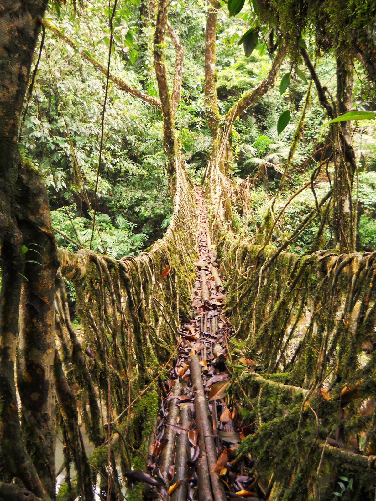
The Nongthymmai bridge, the longest known living root bridge, late in
the monsoon season of 2012. This is 45 minutes from our guesthouse in
the village of Nongriat.

Cliff face and seasonal waterfall through a break in the clouds. In the
dry season, there is no waterfall there at all. This was taken near the
town of Cherrapunji.

Nohkalikai Falls, near Cherrapunji, on a sunny day late in the monsoon
season of 2012. The size of the waterfall increases dramatically after a
major rain. This was taken from a small overlook several kilometers
outside of Cherrapunji.

Cliff face and numerous small waterfalls, from the trail that leads down to our guest house in the village of Nongriat.
The monsoon season is exceedingly green. Tyrna Village, which is where we start our hike to Nongriat.

A wire suspension bridge near Nongriat.

Nongriat village in the green.

The world famous Double Decker living root bridge, which is literally a one minute walk from our guest house.

The Nongriat Guest house in the rain. It got a new paint job since this
photo was taken. It's basic, but it's cozy enough, and you couldn't ask
for a better location.

A typical tasty vegetarian dinner at the Nongriat Guest house....I was supposed to eat all that...

A waterfall just upstream from the guesthouse. This waterfall doesn't exist in the dry season.

One of the most spectacular spots in the area, about 20 minutes from the
guest house. In front is a hybrid root-wire bridge. Behind that is a
true living root bridge, and behind both of them is a waterfall which is
no more than a tiny drip in the dry season.

Monsoon flowers.

Ubiquitous monsoon mushrooms.

The Nongthymmai living root bridge. Picture by Glen (or Kurt?) Saunders.

Erin Potter stands on a living root bridge near the village of Mynteng,
about a 40 minute walk from Nongriat. I took this picture, though it was
with Erin's camera.

Glen Saunders stands mightily upon Tyndrong Bridge. As far as I know,
I'm the first outsider who's reached this bridge in living memory (Glen
is the second). The hike to this spot (about three hours one way) is
one of the best in the area.

Espied by small Khasi children. Photo by Erin Potter.

More Khasi children...they're everywhere in those jungles.

.....And a big pineapple!
So, if any of that looked interesting, get in touch with me at anselmrogers4@gmail.com, and we'll go there!
An Unknown Living Root Bridge

Tyndrong Bridge
[Note: All of the spellings of Khasi villages below are merely my idea
of how they should be spelled...I don't pretend to have a system, and
many of these names I've never seen in writing. I have encountered the
spelling "Tynrong" for "Tyndrong" a few times, and that does seem to be
the more common version. However, I think for practical purposes,
"Tyndrong" is a more useful English rendering of the word, as whenever
I've heard it pronounced it definitely contains a rolled "D" sound
between the "N" and "R" sounds, and if you were asking directions from
some random Khasi in the middle of the jungle, I think you would be more
likely to be understood with "Tyndrong" than "Tynrong."]
A few months back, I decided to go exploring in the rugged jungle
canyonlands west of the Khasi village of Nongriat, in a part of the
northeast Indian state of Meghalaya which has seen almost nothing in the
way of tourism. While on this expedition I discovered, quite
accidentally, a living root bridge which I am now reasonably certain was
previously unknown to the outside world. It runs across a stream just
below the village of Tyndrong, which is about three hours of moderately
difficult hiking from the world famous Double Decker living root bridge
of Nongriat. Living root bridges are exceptional given that they are
among the only forms of architecture that are grown rather than built.
Given that there are less than twenty known examples in the world (which
are all in the East Khasi Hills of Meghalaya, except for one in
Indonesia), finding a new one is no small thing. However, I think that
what stumbling upon a new living root bridge primarily indicates is that
there are probably many more out there which are unknown to the outside
world. There would seem to be a great deal more exploring to be done in
the canyonlands of Meghalaya. Of course, saying that the bridge was
"undiscovered" would not be true. Locals use it everyday, and presumably
have for the past few hundred years. But what is notable is that no
word of Tyndrong Bridge had reached people just a few
villages over.
I've visited Tyndrong Bridge twice now, the second time with my friend
Glen Saunders, who came with me on an expedition I led to Northeast
India that came to an end just a few days ago. As far as I know, he and I
are the only non Khasis ever to have clapped eyes on the bridge, at
least in living memory...and I may be wrong about that, though if any
other non-Khasis have seen it, they've not done anything to make the
outside world aware of its existence.
Getting to Tyndrong from the village of Nongriat is not difficult,
though the information I had regarding the route was largely incorrect
after a certain point. The first time I went I took a number of wrong
turns, and went looking for the village in the wrong part of the canyon.
As far as I can tell, though they're only separated by a few miles and
three hours of moderate hiking, the villages of Tyndrong and Nongriat
are worlds apart. The clans that founded Nongriat and most of the
villages nearby originally came from a settlement upstream of Tyndrong
called Thieding, and ensconced themselves in the valley below
Nohkailikai Falls several hundred years ago, having been evicted from
their homeland after losing a war with another Khasi village called
Mauphu. The Thieding clans were then incorporated into the kingdom of
the ruler of Sohra. But Tyndrong appears to have had rather a different
history: I think it was part of the kingdom of the rulers of Shella
(though I'm not sure). They speak a slightly different dialect of the
Khasi language, and are rather further removed from the rest of the
world. Though Nongriat is physically remote, being only accessible via
ninety minutes of hiking over stairs, the world is coming to it, with
ever more Israelis, Australians, Brits, Japanese, etc. arriving each
year. But Tyndrong remains, for the moment, beyond tourism.
Tyndrong would be worth going to even if there weren't a living root
bridge there. The hike is through jungles thicker and greener than those
around Nongriat, and along the way is one of the most scenic, and also
unexpected, swimming holes within walking distance of Nongriat.
The walk starts behind the Catholic church in Nongriat, where a path
leads south for about 20-30 minutes to another village called Mynteng.
At Mynteng, take any of a number of right turns. Ultimately, you'll wind
up on a path through the jungle to the west of Mynteng, with a stream
to your left. After only a few minutes, you'll come to a very new
looking wire suspension bridge.

The Very New Wire Suspension Bridge of Mynteng. This was built only in
the past few months. There used to be a living root bridge across this
stream, but it got washed out in a flash flood ten or fifteen years ago.
You can still see a small part of the ruined root bridge, upstream of
the new bridge. The wire bridge wasn't there the first time I hiked to
Tyndrong in late October of 2013...everywhere in Meghalaya, things are
changing fast.
After the bridge, you come to a steep uphill section. It doesn't last
very long, though it's one of the very toughest stretches of trail
around Nongriat, and that's really saying something.
The worst part is over when you come to a small clearing. Beyond this is
more stairs leading uphill, though the incline is not as steep. These
stairs lead to a small village called Ramdait, with maybe twenty houses.
From here, you want to take the trail heading left, or west. Just ask
any villager for Tyndrong, and they'll point you the way.
The stretch of trail immediately west of Ramdait is the highest part of
the hike. From here on, the whole way to Tyndrong is downhill, and if
you find yourself heading up, you're going the wrong way. There are a
number of expansive views along this section, along with two smallish
streams. A minute upstream from where the path crosses the second
watercourse there is an extremely beautiful waterfall and swimming hole,
which is worth visiting.

Ramdait Falls and swimming pool. The cascade is about 75 feet high, and
the pool, in late October, was maybe fifteen feet deep in the middle. I
doubt that many tourists have been here, though it's one of the
prettiest swimming holes in the area, and the only one I know of that's
on the side of a cliff rather than down below in one of the main rivers.
The pool is almost perfectly circular, the water emptying out of it on
the south side and flowing in a narrow watercourse for only a few
hundred feet before spilling over the lip of yet another precipice.
Beyond Ramdait Falls, the trail begins to descend, and soon comes to a T
intersection with a steep stairway. If you go uphill, the stairs will
take you, after an agonising 1500 foot deathmarch, to a village with a
roadhead called Mausahew. However, the way to Tyndrong is downhill, to
the left.

A rugged Khasi chap on his way to Mausahew, at the intersection. Glen
Saunders and I encountered this fellow as we were walking back to
Nongriat, having visited the Tyndrong Bridge as part of a long day
hike...yes, he posed for that picture, though he was walking along
behind us for a while, shooting things with his slingshot. As nearly as I
can tell, all Khasi boys learn to use slingshots at a very young age,
much to the detriment of the local bird and ground squirrel populations.
After the intersection, one heads down a series of steps that get
gradually less steep. The jungle here is thicker and greener than around
Nongriat, and the soil becomes red in color. There are vastly more
ferns. I get the impression that the area gets more rain than Nongriat,
perhaps because it's on a south facing slope, directly in the path of
the moisture coming up from the Bay of Bengal, while Nongriat faces
east.
In some time, you'll come to a sort of square stone enclosure, situated
at the point where the path splits into three branches, one straight
ahead, due south, one to the right, down from the enclosure, and one off
to the left. When I first came to this point, I was forced to guess
which way to go. There was nobody around (I had'nt seen anybody for
hours), so I decided to go in the general direction I had thought
Tyndrong was. The path at this point leads along the crest of a ridge
that runs across the top of a rugged peninsula. This is formed by the
stream at the bottom of the canyon Nongriat is in flowing into the much
larger river of the next canyon over. I had been told that Tyndrong was
at the southern edge of this peninsula, so I went straight....which was
wrong. I was now walking away from where I meant to be going.

The stone enclosure. It seems to be quite old, and looks like it might
have been meant as a camp...if you ever come this way, make sure you
turn right here, that is, if you mean to get to Tyndrong.
I wandered for quite some distance through thick, lonely, and very
unfamiliar jungle. I had plenty of food and water with me, and a huge
pack, but it was late in the day and I was considering making an about
face, and perhaps beating an ignominious retreat to Nongriat, when I met
a random fellow out working in the jungle. Needless to say, I'm pretty
sure a Delawarean coming down the trail at him was the last thing he
expected. We had a long conversation, in broken bits of four different
languages (English, Hindi, Khasi, and a bit of Assamese, largely from
his side), and after much effort he pointed me in the right direction.

A good Samaritan
When I came back with Glen Saunders, I didn't repeat my mistake. After
the enclosure, it's perhaps a twenty minute walk to edge of Tyndrong.
All you have to do at that point is stay on the most prominent trail.
One path leads to the right, and then one comes in from the left, but
you keep straight, and soon you'll reach the top of the village.
The first time I came to Tyndrong, I approached it from rather an odd
direction. I wound up wandering into the village from behind its large
Presbyterian Church, hearing it long before actually stumbling into it.
While still enveloped in the jungle, without a clear impression of where
I was going, I began to pick out the sound of children playing loudly,
accompanied by mid to late 90's dance or techno (if there is a
distinction) music (there is no escaping it, even in remotest
Meghalaya). This last time, when Glen and I walked to Tyndrong as a day
hike, there was again trashy Euro pop playing somewhere, perhaps even
from the same house.

The Presbyterian Church in Tyndrong. My first view of the village.
Tyndrong lies on a long narrow slope, with valleys on either side, which
runs down towards a river which is still some distance below. I had
been told that the river was only around twenty minutes walking from the
village, and on first arriving in Tyndrong I still didn't think I had
reached the my intended destination because the bottom of valley still
seemed to be somewhere between 1000-1500 feet below me...however, again,
my information was incorrect. Tyndrong is actually rather higher in
elevation than Nongriat, and getting to the river from the village,
though not an especially difficult hike, still takes a little while.

The Catholic Church in Tyndrong, and a dog. As far as I know, Tyndrong
is divided between the Presbyterians and Catholics, with Catholics (I
think) forming the minority. It was actually from a Keralite Catholic
priest who was conducting a mass in Nongriat that I first heard about
the village back in 2012. I think it's a fairly safe assumption that
most of the outsiders who have reached Tyndrong have gone there on
business associated with the Church.

A large pool about 45 minutes below Tyndrong. This is part of the river
that drains what I call, for lack of any other name that I know of, "The
Great Western Canyon." The huge gorge that Nongriat is at the bottom of
is only a side canyon to this much larger chasm. I would spend the next
several days exploring this canyon, which is, as far as I can tell,
virtually untouched by tourism. The pools in the river here are much
larger and deeper than those near Nongriat, and they're full of big
fish. The water in them isn't quite as clear as in those around
Nongriat, probably because this river drains a much bigger area. Not far
downstream from this point the river apparently becomes navigable by
inflatable rafts, and it's possible to float to Bangladesh. Two of the
very few other tourists to come to Tyndrong walked through the village
in order to the gain access to the river and float to the next country.
The first order of business when I arrived in Tyndrong was to find a
place to stay for the night. It of course was not hard to find someone
to talk to: Wherever I went I immediately became the center of
attention, and pretty soon I had virtually the entire village was
wondering what the hell I was doing there.
While I was totally dependant on the hospitality of the villagers, I
didn't want to impose. Trying to find some place to sleep, I spent a
little while trying to locate either Tyndrong's headman or the local
school teacher, perplexing numerous villagers along the way. Finally I
asked a random, rather concerned looking man if it was possible for me
to stay in the Presbyterian Church for the night. He didn't know
English, though he did know a little of what he called "Bazaar Hindi,"
and that was enough for us to get by. He decided then and there, for
reasons that I didn't quite understand, that I was his responsibility,
though at first he didn't seem quite happy about it. He told me that
there was no hotel in the village, and that the people of Tyndrong were
poor, and wouldn't be able to provide me with much in the way of food.
He seemed to assume, because I was from elsewhere, that I would be picky
and unsatisfied with his hospitality. But he still offered to let me
stay at his house.
The man had something like seven children, including a baby who was less
than a year old. His home was badly eaten by termites, and resembled,
except for the corrugated metal roof, what many northeast Indian houses
made of wood must have looked like before the widespread introduction of
concrete. I spent much of the remainder of the day sitting in the the
man's home being gawked at by small khasis. Soon, not only had the man's
entire family come back to the living room, but many of their friends,
and a large portion of the little kids of the village, were crowding
into the house. At one point there must have been at least 25, plus
several adults.
I did my best to talk with my host, who seemed to warm up to the idea of
my being there after a cup of tea. His Bazaar Hindi was rather a
different commodity than my smattering of Formal-to-the-Point-of-Being-
Risible Hindi, but we made it work as well as it needed to. After a
while, one woman, who worked at the village school, came in, and she
spoke a certain amount of English, though I think she had quite a bit of
trouble with my accent. One of her first questions was whether I was
from Guwahati or Calcutta.
By this point, I still wasn't sure how far away the river at the bottom
of the canyon was. I also was pretty dirty after having spent the whole
day hiking with a giant trekking bag on my back, so I thought I would
try to get in a swim. I tried asking my host the way to the river, but
he decided that he would lead me there personally, though he didn't
understand that I meant the main river at the bottom of the
canyon....and that misunderstanding is in fact the only reason I
blundered into Tyndrong Bridge at all.

The house I stayed in. I took this picture on my second visit, when me
and Glen Saunders came back to Tyndrong to get more pictures of the
living root bridge, the few pictures I managed to take on my first
expedition having not turned out very well (they were too dark, and
there was no sense of scale on the bridge). Those kids in the doorway
are two of my host's children, though he, like most of the men in the
village, was out working in the jungle at the time. I did say "hi" to
his wife though. That bag at the right hand side of the picture is full
of Indian Bay Leaves, which seem to be the area's main crop during the
middle of the winter. They're used in flavoring, though they also burn
really nicely....me and my companions on my most recent trip to
Meghalaya profitably spent a large portion of our time in Nongriat
burning bay leaves, their highly flammable properties having been
demonstrated to us by a mysterious intoxicated old Khasi fellow who
shared our campfire for all of three minutes.
My host now started to lead me to a place where I could get a swim in.
We started just behind his house, and then took a trail that led
straight down from the village, into a narrow valley with a little
rushing stream at the bottom.

I just really like this tree...on the way down to Tyndrong Bridge.
It didn't take long to reach the stream. I immediately saw that the path
we were on led across the watercourse by way of some sort of bridge.
But when I first saw Tyndrong Bridge, I wasn't immediately sure that it
was made from roots that had been trained across the stream from the
opposite bank. From some angles, the bridge looks like it's just made of
wood and bamboo poles. Also, I had been specifically told that there
were no living root bridges beyond Mynteng. But, as I got closer, I saw
that the bridge did indeed consist of several large roots that had
unmistakably been trained across the watercourse. The actual flooring of
the bridge was made of bamboo, and there was only a railing on one
side. The bridge appeared to have been damaged at some time, perhaps by a
flash flood that had removed one side of it, or perhaps there had been
some accident when the thing was initially being grown, and the other
support never fully came into its own.

Me crossing Tyndrong Bridge. Photo by Glen Saunders (with a camera owned
by Erin Potter). Though the bridge is missing a large part, it's still
significantly more sturdy than most of the bridges near Nongriat. The
rather odd root on the right side of the picture may once have been part
of the missing support.

The view from the opposite side. Photo by Glen Saunders. From this
angle, the bamboo poles rather decrease the aesthetic appeal of the
bridge, but, then again, if they weren't there it would be much harder
to walk on. Unlike most of the other living root bridges I've seen, this
one has yet to become a tourist attraction. Next to the living root
bridge is a small wire suspension bridge, which I think was an attempt
to phase the living root bridge out. But the wire bridge is now ruined,
and the living root bridge is once again the main way across the stream.
The railing on the right side of this picture has a bunch of gashes in
it, some of them quite deep, where people have been hitting it with
machetes. When my host led me here the first time, he barely even looked
towards the bridge, and seemed to find my interest in it somewhat
strange. I think that for him a living root bridge is a totally
commonplace object.

A view looking up at the tree whose roots were harnessed to form the
bridge. Most of the rubber trees that are used in the construction of
living root bridges have multiple trunks, and vastly more branches.

Glen Saunders stands mightily upon the span. I don't think that Tyndrong
bridge is by any means the most beautiful of living root bridges, but
it is one of the more unusual. Judging by the thickness of the roots,
it's safe to assume that the bridge is well over 150 years, and may be
as old as 250. I wasn't equipped to do any precise measurements, but
the two larger roots that make up the side railings are in the vicinity
of two feet thick, which means they've been there growing thicker for
quite some time. The bridge may not be the oldest (known) living root
bridges, but it's certainly one of the older ones....it was probably
laying across that stream when Abraham Lincoln was president, when the
Tai-ping's were rampaging across southern China and the later Mughals
were still tottering on in Delhi.

Glen, facing the other way now. Perhaps even more unusual than it's age
is the fact that Tyndrong Bridge seems to have been designed differently
from any of the other living root bridges that I've clapped eyes on
(which is most of them by this point). To begin with, on the side which
is still intact, it has two large supports, as opposed to what one
usually sees which is a single railing. Assuming that the missing side
of the bridge was the same as the surviving one, Tyndrong Bridge may
have had five primary roots instead of the usual three. Also, on
Tyndrong Bridge there are practically none of the smaller intertwined
roots which on most living bridges make up a large part of the structure
and take a major portion of the stresses that the bridges need to
handle. In virtually all other root bridges the secondary roots are a
vital part of the overall design, but here they're almost entirely
absent. It's interesting to speculate how one would have walked across
the bridge when the other side wasn't damaged: Without the secondary
roots, it would be harder to make a floor for the bridge. Though the
bamboo poles that are there now look a little ad-hoc, the bridge may
have always had an artificial walkway. But what can definitely be said
about the design of Tyndrong Bridge is that it is abnormal for its
simplicity. What exactly this means I'm not sure. Perhaps it is actually
older than all the other known living root bridges, and represents an
earlier, more primitive way of making them. Or, maybe the people of
Tyndrong all those generations ago saw other living root bridges and
then decided to make their own, and the difference in design is a
cultural matter. Or, maybe, the tree itself is just a slightly different
variety of Rubber Tree. Or, maybe, for some reason, it was just easier
to do it this way in this case....or, hell, maybe it was aliens.

Some local ladies having just crossed the bridge. On the second
expedition, when Glen and I went there. It's still in use, though where
this path leads, other than north along the eastern wall of the Great
Western Canyon, is unknown to me. I walked along this path for a few
minutes one morning, and though I didn't see any more living root
bridges, the jungle there was darker and greener than anything on the
other side of Tyndrong. If indeed there are lots of other living root
bridges in the Khasi Hills waiting to be revealed to the outside world,
this path would be a good place to start looking.
When I first came to bridge, I didn't stay very long. My host
immediately started leading me upstream in search of a suitably deep
swimming hole. There was no path, only boulders with water running under
them and greyish rock walls close on either side. The only way up was
to climb. Suddenly, as the fact that I seemed to have discovered a
living root bridge unknown to the outside world slowly sunk in, I found
myself climbing precariously from hand hold to hand hold up slippery
boulders into a jungle canyon that in all likelihood no other outsider
had ever laid eyes on (now that's a sentence). As it was the end
of October, the rainy season was long gone, and the Khasi Hills were
drying out. Finding a pool deep enough to swim in required risking life
and limb...at least for me. My host appeared unbothered by the dangers
of the place. In fact, he led me up into the canyon barefoot.

My host in Tyndrong...A jungle man indeed.

A waterfall in the stream above Tyndrong Bridge. Though my host didn't
seem to find much interesting in the living root bridge, he went through
fairly great pains to show me this waterfall, which is certainly worth
seeking out. He seemed to really enjoy the spot...as I recall, we rested
here for a little while and had a longish conversation about the
relative merits of Nongriat and Tyndrong in Bazaar Hindi.
We did ultimately find a suitable swimming hole, and I did get a little
bit cleaner. However, there was another trial right next to it, and as
it turned out our life and death adventure up the watercourse wasn't
really necessary...though we did see the big waterfall pictured above,
so I suppose I shouldn't complain.
After that, we went back to his house for dinner. There really wasn't
much for me to do in Tyndrong after dark but sit around on the floor and
have awkward exchanges...you could do worse.

My host's baby reminded me of my niece.

My hosts mother (I think, but I'm not sure...which is embarrassing...maybe his mother in-law).
We had what constitutes a typical poor Khasi's normal meal: a plate of
white rice with a little bit of salt and a small cube of pork fat. My
host had a little bit of whiskey and afterwards got rather more
talkative, though, honestly, now that he wasn't carefully picking his
words I had no idea what the hell he was saying for about 70% of the
time. Still, he seemed to be enjoying himself.
Over the course of the following days I went on from Tyndrong and
explored far into the Great Western Canyon, though I think that in the
end I did little more than scratch the surface of the place. My
experience just in Tyndrong showed me that, though the world is coming
to Cherrapunjee and Nongriat, the larger part of the Khasi Hills are
virtually unexplored by outsiders, and yet these untouristed regions are
as beautiful, if not more so, than those which are receiving most of
the attention these days. Given that there are parts of Northeast India
vastly more remote than the Khasi Hills, I think it's safe to say that
most of what's worth seeing in that region remains unknown.
I suspect that in the canyons of Meghalaya there are many more living root bridges than the world knows about.

My host and the newest member of his family. By this point, he was
smiling all the time and looking a little less severe, though his camera
face remained rather on the serious side. I was hoping that I was going
to be able to say hi the second time I visited Tyndrong, but he was
out, and Glen and I needed to get back to Nongriat before the sun went
down. Still, I owe this man quite a bit for showing me the way to
Tyndrong Bridge, even if that hadn't been where he was trying to lead
me. If anyone reading this ever makes it to Tyndrong, make sure to look
him up.
DIRECTIONS TO TYNDRONG BRIDGE FROM NONGRIAT:
Starting in Nongriat, walk to Mynting-Ramdait-Tyndrong. At Tyndrong,
find the large Presbyterian Church. In back of this is a large concrete
water tank with a tap. Across from the tank is a blue house, badly
damaged by termites. Walk behind the house. There you'll acquire a
narrow path leading downhill. Keep taking the paths downhill until you
come to the stream and Tyndrong Bridge. The waterfall pictured above is a
little way upstream and requires a certain amount of scrambling.
Mehrauli: Qutb Minar Complex

A highly decorated prayer niche. Part of the large mosque next to the
Qutb Minar in Mehrauli. This part of the complex dates from the early
13th century, and was constructed by Iltutmish, the second ruler of the
Mamluk, or Slave, dynasty of the Delhi Sultanate. This panel displays a
variety of different decorative motifs, including two varieties of
Arabic calligraphy. The carvings on the row furthest to the right are in
an early Arabic script called Kufic, which seems to have
developed in the fourth century, well before the advent of Islam. The
earliest surviving Korans were written in the Kufic script, and the
system of writing was used by a number of groups of central Asian
Muslims who were culturally similar to the Mamluks. The carvings on the
next row over are fairly stylized representations of leaves and vines,
while the third row consists of more Arabic carvings, in this instance
in the much later Nashki script.
My blog posts on Delhi have largely focused on the more obscure, or at
least less touristy, places in that vast city. Yet, sometimes, it's good
to go back and visit the classic sites. I've already done a blog post
on the Mehrauli Archaeological Park, and at some point I'm going to do a
post on the interesting things to see in Mehrauli Village, which I
visited a few months ago. That being the case, it seemed fitting that I
should do a write up on what most people come to see when they travel to
Mehrauli, namely, the Qutb Minar and the complex of early Sultanate
buildings around it.
The Qutb Minar is hardly off the beaten path. In fact, by some
estimates, it's India's most visited tourist attraction, beating out
even the Taj Mahal (probably due to the Qutb's very close proximity to
an international airport). Despite this, the Qutb Minar isn't
particularly well known outside of India. The first time I can remember
seeing it was in an old obscure Bollywood movie from the seventies (it
had something to do with a poor kid struggling on the streets....as I
recall, it wasn't very good). While the Taj is for many people the very
symbol of India, the Qutb Minar is, at best, and big weird tower in
Delhi.
Yet, in some ways, the Qutb Minar would perhaps make a better symbol for
India than the Taj. Work on the minaret began in the 1190s, just after
the city's conquest by Muhammad Ghori, whose general and governor for
the region, a Turk by the name Qutbuddin Aibak, would go on to found the
first great Islamic kingdom based in Delhi, that of the Mamluks. The
Qutb Minar therefore comes from the very earliest period of Islamic
building in India, a time when many of the features we associate with
classic Indian Islamic architecture had yet to develop, and the builders
had to rely to a very large extent on Hindu artisans. This resulted in
numerous Hindu motifs being incorporated into the Islamic buildings,
creating a genuine synthesis of Islamic and Indian artistic
sensibilities. Though the Taj is arguably the more beautiful building,
it is also more "foreign" to India, as it represents a much more fully
developed stage Indo-Islamic architecture, where the indigenous
elements, though still present, are more thoroughly masked, while some
of its most striking features, such as its pietra dura inlaid
stonework, are purely foreign innovations. However the Qutb Minar,
though it is a monument to a non-Indian religion, is nonetheless a
building constructed with the skills available to the Indian builders of
the period.

A view of the Qutb Minar at dawn, from Smith's Folly. The two buildings
next to it are the Alai Darwaza, dating from the early 14th century, and
the tomb of Imam Zamin. I visited the Qutb Minar first thing in the
morning. This was right at the point in the day where the sun started to
burn through the early morning fog/smog (fmog?) endemic to Delhi. Here
you can clearly see each level of the structure. The first was
constructed by Qutbbudin Aibak. Three more were added to that by his
successor Illtutmish. Over time, the uppermost level was damaged, and
then removed and replaced with two new levels by Firoz Shah Tughlaq in
the latter half of the 14th century. Hence the variation in style
between the first three levels and the last two. The three Mamluk levels
are made of sandstone, while the two Tughlaq levels are composed of
marble. Smith's Folly was an addition the British made to the Qutb
Minar during a period of restoration in the early 19th century. It was
originally a cupola that would go on top of the Minaret, but it was soon
deemed to be stylistically out of place, so it was removed from the
building and placed in that lawns nearby. Now it provides one of the
best views of the Qutb Minar in the complex.
Looking straight up at the Qutb Minar, just as the sunlight was getting
stronger. Surprisingly, there is still some debate as to exactly what
purpose the Qutb Minar served. It is frequently said that the building
was meant as a tower from which a muezzin could climb up and issue the
call to prayer for attendees of the mosque that was built next to it.
But there's a problem with this theory, namely, that if the muezzin
climbed to the top of the minaret, it would be impossible for anyone to
hear him. He might possibly be able to be heard from the balcony on the
first floor, but if the building was meant specifically for giving the
call to prayer, why build the other three floors? Other sources describe
the Qutb Minar as a giant watch tower, or a huge landmark to announce
the location of the adjacent mosque, while some still implausibly
maintain that the structure is actually a pre-Islamic Rajput building.
What the minaret seems to be modeled on is another tower in Afghanistan,
built by the same empire that Qutbuddin Aibak branched off from, called
the Minaret of Jam. The purpose of that building seems to have been
simply to commemorate the triumph of Islam, and it seems fairly certain
that the Qutb Minar was built for the same reason, even if it also
probably served other, more mundane functions associated with the
mosque. But the main point of the thing seems simply to have been to
impress, which it most certainly does, even after 800 years.

Close on some of the inscriptions on the side of the minaret, a little later in the day.

Close on the first floor balcony, and the top of the part of the
structure built by Qutbuddin Aibak (with the addition of parrots for
scale and added visual drama). Though the Qutb Minar is impressive from
a distance, it's only when you get up close to it that you get the full
effect. That slightly silly looking railing you can see on top of the
balcony was another British addition from the first half of the 19th
century. Of course, then you were probably allowed to climb up the
thing, and I suppose the Brits didn't want people falling off.

The second floor balcony, which is basically a less ambitious version of the first floor.

The altogether more threatening looking third floor.
Surrounding the Qutb Minar is a large collection of early sultanate
buildings, many of them incorporating fragments of earlier Rajput
temples, along with a few Mughal structures. By far the most important
building in the complex, other than the Qutb Minar itself, is the
mosque. This is usually referred to as the Quwwat Ul-Islam, or Might of
Islam, mosque, though that name was only given to it relatively
recently. The mosque is one of India's earliest, and is rather a
puzzling collection of ruins: The main prayer hall was built by
Qutbuddin Aibak, and then additions were made both by Qutbuddin Aibak's
successor Illtutmish and then by Alauddin Khilji, but they both failed
to complete whatever it was they were planning, the result being that
the complex is characterized by many awkward arrangements and unfinished
buildings.
Some of the building materials used in the Quwwat Ul-Islam Mosque are
famously parts of Rajput Jain and Hindu temples which the Muslims
dismantled after taking the city. The whole complex was built on the
ruins of a large Rajput fort called Lal-Kot. Strangely, therefore, the
Qutb Minar complex, despite being a monument to the triumph of Islam, is
the largest and best preserved collection of ancient Hindu ruins in
Delhi. Virtually all Hindu temples in Delhi before the 12th century were
destroyed by the invading Muslims. Therefore the temple columns which
the Muslims incorporated into their own buildings are some of the very
few fragments of the pre-Islamic history of Delhi that come down to us.

The tomb of Imam Zamin. I've found conflicting information on who Imam Zamin was. Lucy Peck in her Delhi: The Architectural Heritage says
that nothing is known about the man, while www.archnet.org claims that
he was a saint from central Asia. This building actually comes from a
much later period than most of the structures in the Qutb Minar complex.
The dates from both sources agree (well...archnet says 1538, Lucy Peck
says 1539). That puts it in the early Mughal period, just before Humayun
was kicked out of India and Sher Shah Suri briefly took over. The vast
majority of Mughal architectural achievements were still to come at this
point, and this tomb would seem to have more in common with earlier
Sultanate constructions. I do believe that this is the only building
from this period within the ticketed monument, though the Jamali Kamali
mosque and tomb in the adjacent Mehrauli Archaeological Park are from
about twenty years earlier.

An opening into the Alai Darwaza, a finished gateway to an unfinished
extension of the Qutb Minar mosque planned by Alauddin Khilji. The
building dates from the early 14th century, after the introduction of
true arches. Alauddin's plans called for a much bigger mosque compound
with four large gateways, though this is the only one which ever
actually came into being. Alauddin Khilji is one of the more important
and interesting rulers of the Delhi Sultanate, and he leaves behind a
decidedly mixed legacy. The man appears to have been one of the greatest
campaigners ever to rule in Delhi, and in his capacity as a military
leader seems to deserve credit for successfully defending India from the
Mongols. But the downside of this was, instead of the Mongols
overrunning most of India, Alauddin Khilji's armies penetrated further
into the sub-continent than any Muslim invaders had previously. And
while with later Muslim dynasties, such as the Tughlaqs and to an even
greater extent the Mughals, we can talk about them incorporating their
conquests into pan-Indian empires, many of the campaigns launched by
Alauddin Khilji, such as those in South India, seem to have been more
concerned with plunder than with actually placing those areas under
Sultanate control. He also imposed stringent economic reforms, the
purpose of which were ultimately to fund his military machine. They
consisted in higher taxes and strict price controls on important
commodities such as grain, the measures being enforced by severe
punishments. Opinions vary widely as to the success of these measures.
The Wikipedia article on the man gives one the impression the entire
society benefited from them. Lucy Peck, who is my main source on the
actual buildings in Delhi, gives a mixed appraisal of the market
reforms, saying that they mainly served to benefit the Muslim
aristocracy while greatly disadvantaging the Hindus. John Keay in his India: A History portrays
the reforms as being successful only in the short term, and I suspect
that his version of the events is the most accurate. The result of
fixing such low prices on so many commodities was that profits went down
with the prices, reducing purchasing power and finally putting people
right back where they started. Additionally, the whole scheme depended
on a huge network of spies and government agents, who were ultimately a
part of Alauddin Khilji's military machine, an organization that only
functioned with Alauddin Khilji at the controls. Once he died, his
kingdom went immediately into decline, and the economic reforms he had
tried to instate evaporated.

The side of the Alai Darwaza. Alauddin Khilji's additions to the Qutb
Minar complex would seem to characterize the man as someone who was
extremely talented and yet hopelessly over ambitious. The Alai Darwaza
is one of the most impressive buildings in the complex, and indeed in
all of Delhi, yet it is also the only part of the grand scheme for a
much bigger mosque that actually materialized.

Ornamental niches on the Alai Darwaza, with parrot.

Jali screen window in the side of the Alai Darwaza.

A large Star of David on the inside of the entrance to the Alai Darwaza.
The Star of David frequently appears in Islamic art, and is often seen
as a decorative motif on historical Islamic buildings throughout India.

Alauddin's Madrasa, one of the few structures in the Qutb Minar Complex
that Alauddin Khilji actually completed. This view is looking through
what is said to be Alauddin's Tomb. The madrasa contrasts markedly with
the Alai Darwaza as it is totally lacking in decoration, the outside
layering of the building having been stripped off long ago, presumably
to provide building material elsewhere.

Iltutmish's Tomb. Iltutmish was the third ruler of the Mamluk Sultanate.
Once a slave of Qutbuddin Aibak, he overthrew Aibak's son (who was only
on the throne for about a year) in 1211, and was in power for the next
two and half decades, making his reign the longest of any ruler during
the Mamluk dynasty. His time on the throne seems to have been largely
occupied both with suppressing revolts in what were theoretically the
eastern provinces of the Mamluk domain, and with dealing with the
successive waves of central Asian refugees being swept into India by the
campaigns of Genghis Khan and his immediate successors. After his death
in 1236, the kingdom descended into a long period of instability,
during which Delhi had it's only female ruler, Iltutmish's daughter
Razia. Although Qutbuddin Aibak started construction on the Qutb Minar,
it was Iltutmish who finished it. He also started work on an extension
to Aibak's mosque which, like Alauddin Khilji's, was never completed.

Looking through the south entrance arch of Iltutmish's tomb. It is not
known if the tomb once had a dome or not. It certainly looks as though
one belongs there, but there is some debate as to whether the walls of
the structure, which are surprisingly thin, would be able to support
one. There is a possibility that the tomb was always open to the sky,
as it is now, in order to fall in line with an oft ignored Islamic
belief that a gravestone must be exposed to the elements in order to be
blessed.

Corner arch in Iltutmish's tomb.

The Alai Minar, perhaps the world's greatest monument to failed self
aggrandizing vanity projects. The Alai Minar was an attempt by Alauddin
Khilji to build a minaret twice the size of the Qutb. He only managed to
finish part of the first story before his death, and his successors
never felt moved to keep going with the project. Now the weird
unfinished rubble mass sits forlornly north of the mosque, ignored by
the vast majority of visitors.

The great arched screen at the western end of the Quwwat Ul-Islam
mosque, behind which was once the mosque's prayer hall. This part of the
mosque, along with the first story of the Qutb Minar, are the earliest
Islamic structures in the complex, having both been built during
Qutbbudin Aibak's brief reign.

The arches of the Quwwat Ul-Islam mosque must rank among India's most
pronounced Hindu-Islamic artistic syntheses. Here, the form of the
structure is Islamic, as are the various decorative motifs such as the
calligraphic carvings and the renderings of plant life. But the actual
artisans who built the screen were almost certainly Hindus who would
have used methods familiar to them from working on temples. The arch
here is not a true arch that takes the stresses from the surrounding
structure, true arches having not yet arrived in India. Rather, the
construction is trabeated, with the individual blocks of masonry on both
sides of the arch extending further outwards the higher up they go, the
blocks finally meeting each other at the top, the lower blocks being
held in place by the weight of the blocks above them. This was a method
that was well established in India, yet here it is being used in the
construction of arches that on first glance look like the true arches of
classical Islamic architecture.

Incredible carvings on the side of the arch.

Carvings on the side of the Quwwat Ul-Islam arched screen. Though the
decorative motifs here, such as the Arabic calligraphy and the
depictions of plant life, are common features in Islamic buildings
throughout the world, the very exuberant, dense, high relief, and
somewhat less stylized, manner in which they have been rendered is
unusual, and much more in-keeping with Hindu artistic sensibilities than
with those more often associated with Islam. Though the carvings do not
include representations of living beings (the depiction of which Hindu
sculptors excelled at), the work here still has a remarkably un-Islamic
lack of restraint.

Stone vines and flowers, on the Quwwat Ul-Islam mosque screen.

A prayer niche on Iltutmish's extension of the mosque. Here, the
carvings and calligraphy are more restrained, and also even more highly
stylized, than on the earlier portions of the mosque. It's remarkable
that the style of the carvings evolved so much over the course of only a
few decades. The shallower relief carvings here, while still
incorporating many indigenous elements, are nonetheless more typically
Islamic.

The famous Delhi Iron Pillar. This is the oldest single element of the
Qutb Minar complex, and of all of Mehrauli for that matter, having been
around 800 years old by the time the Muslims arrived. It was not forged
in Mehrauli, but instead seems to have been brought there at some point
by the Rajputs, though from where is a matter of debate. An inscription
on the side of the pillar states that is was first placed on "Vishnupada
Hill" by a certain king "Chandra," but, while there are a number of
theories, the actual location of Vishnupada is unknown. "Chandra" is
generally regarded to be Chandragupta II of the Gupta dynasty, though
there's a problem with this as well, namely, that there were a number of
other important "Chandras" at roughly the same time, and the
inscription never mentions the word "Gupta." It is largely taken up with
extolling Chandra's achievements, and the pillar itself seems to have
been a monument to the man, and a way of legitimizing his dynasty's
rule. There is reason to believe that it was once topped with an idol of
Garuda, though that has since been lost.

Close on the Sanskrit inscription on the side of the Iron Pillar,
written in an early Indian writing system called Brahmi. The pillar has a
number of extremely unusual characteristics, which once made it among
the world's foremost metallurgical mysteries. For one, the iron of which
the pillar made is of a purity that would not be matched in Europe
until the 19th century. Even more extraordinary is the fact that after
around 1700 years of exposure to the elements, the pillar has barely
rusted. Recently, this has been explained by the high amount of
phosphorous used in the forging process. This phosphorus, some of which
wound up in the object itself, caused the formation of a protective film
composed of a substance called "Misawite" when it reacted with oxygen
in the air. This film, which is very slowly growing, has protected the
pillar from further corrosion. Thus, though the pillar has rusted, it's
rusted in an usual way which has prevented it from corroding as much as
one would expect. Incidentally, if one looks up "Misawite" online, most
of the hits one gets are articles about the Delhi Iron Pillar.

Colonnade on the north side of the Quwwat Ul-Islam mosque, where Hindu
temple columns have been stacked up one on top of another. The building
materials here came from 27 Hindu and Jain temples that were destroyed
by the Muslims. Usually, this act of destruction is portrayed as simple
Islamic iconoclasm on Qutbuddin Aibak's part, though there are those who
argue that the disassembly of the temples had political rather than
religious motives. It is worth pointing out that Hindu rulers regularly
destroyed each other's places of worship and appropriated each other's
idols, as doing so was regarded as a way to weaken the other ruler's
power. It certainly seems to be the case that the destruction of a
conquered ruler's temples was common practice in India before the
Muslims took over in Delhi, and it is likely that Qutbuddin Aibak was
aware of the political significance of what he had done. Yet, given that
Qutbuddin Aibak was not a Hindu himself, it is unlikely that he would
have viewed the Rajput temples as being the source of any genuine power
for those who built them. It is also telling that Qutbuddin Aibak
demolished temples elsewhere in India, and that the destruction of Hindu
shrines was often seen as a deed of great merit by the Ulema of various
rulers of the Delhi Sultanate. Another possible, if rather more
prosaic, motive behind Qutbuddin Aibak's destruction of the temples
might have been that he simply needed to get his hands on large
quantities of dressed stone. Since Hindu temples from this period were
built without mortar out of carved blocks stacked on top of each other,
disassembling and reassembling them is not that difficult. Certainly, in
modern times, to restore an ancient stone Hindu temple that has
collapsed is not that much of a technical challenge, while for Qutbuddin
Aibak, building a whole whole new structure out of the already carved
pieces of a Hindu temple would be vastly easier than starting from
nothing. The real motivation behind the destruction of the temples was
probably a combination of all three of the above motives, though in all
likelihood Qutbbudin Aibak viewed the destruction of the idolatrous
places of worship as a good and righteous deed, and therefore in his own
mind that was probably his chief justification. Whatever the case may
be, his actions do not smack of religious tolerance.

A kirtimukha, or stylized monstrous face motif, that one encounters in
Hindu and Buddhist temples all throughout Asia, at the top of one of the
Quwwat Ul-Islam mosque pillars. Given the Islamic proscription against
the depiction of living creatures, it seems odd that they would allow
there to be so many of them on display in a mosque. It is usually
assumed that carvings were covered with white plaster, though there is
apparently no direct evidence support this.

Column with various typical Hindu decorative motifs, including vases,
kirtimukhas, and yali's (mythical elephant/lion hybrids).

Close on a fairly classic Hindu temple column. Note that many of the
motifs that appear here would not be out of place elsewhere in the
mosque, in particular the representations of plant-life.
So, that was the Qutb minar complex. Like I said above, at some point
I'll get around to the least visited part of the vast complex of
historical ruins in and around Mehrauli: Mehrauli Village
itself....though it may be a while, so, stay tuned!

Smith's Folly, the cupola that the British briefly added to the Qutb
Minar, and then took down after only a few decades because they thought
it looked silly.
Hampi Pt. 2

The 15 foot tall monolithic Kadalekalu Ganesha statue, in a shrine
behind Hemakuta Hill. Carved out of a single granite boulder, this is
one of the largest representations of Ganesha in the region. The word
Kadalekalu means "Gram" in the local language, which the statue's belly
is thought to resemble. In his hand, Ganesha is holding a rice cake,
which he's eating with his trunk. I was surprised that this photo turned
out as well as it did, given how little light there was in the shrine.
The great thing about Hampi is that it offers an almost limitless amount
of places to explore. While there are a number of "must see" sites like
the Lotus Mahal and the Vittala Temple, there are also a huge number of
ruins and natural features in the area which see relatively little
traffic. This post is going to focus on the less visited parts of the
ancient capital, along with a few of the major sites that I missed on my
first day exploring the ruins of Vijayanagara. As you might expect,
here's much more to Hampi than what I've posted here. I think you could
spend your whole life studying the area and still not see absolutely
everything.

Columns carved with Yalis in a subsidiary, and as far as I can tell
recently restored, shrine up a short street that leads to the north of
the Vittala Temple. The entire area are the Vittala Temple is covered
with the remains of marketplaces and other temples, some of which are
still in a totally ruined state.

Travelling north of the Vittala Temple, along the banks of the
Tungabhadra, I came to a small, though easily accessible, cave. Here I
found lots and lots of potsherds. After this point, once I knew what to
look for, I realised that almost anywhere you look in the Hampi area,
the ground will be covered with fragments of pottery. That being said, I
have no idea how old these these pieces here are. Pottery of exactly
the same design as what was used during Vijayanagara's heyday is still
very much employed in the area. These fragments could be 50 years old,
or they could be 500 years old. However, there were a few things about
the location of these particular potsherds which led me to believe that
they had been around for a while. They were embedded in a pile of debris
which was the result of rocks shifting around inside the cave and
fragmenting. However old the potsherds were, they predated the pile of
debris they were embedded in, which did not look recent. Also, the cave
was in a fairly remote area, which, as far as I could tell, was not a
site of human habitation any time in the past few centuries.

The top of a pot, of the same design as the potsherds above, in an
adjacent chamber. Given that the caves that honeycomb the granite hills
in the Hampi area are so much cooler than the outside, I suspect that
people who lived in the area used them for storing items that needed to
be kept out of the heat. Many of the chambers that I looked into had
broken pots in them. My guess is that there is probably still quite a
bit of archeology to be done in the caves. For one thing, it wouldn't
surprise me if the very first people who settled in the area selected
the site because it offered them literally thousands of caves that they
could use as natural shelters. Note the white object on the left of the
broken pot, and the crescent shaped thing to the right. Those aren't
trash, but rather the segments of the exoskeletons of deceased
millipedes.

Marshlands in the middle of the Tungabhadra, looking south. Here you can
just make out the Vittala Temple below the lefthand hill. The ridge in
the center of the picture is Matanga Hill. The tiny point on top of the
hill is the tower of a temple.

A view of the Kadalekalu Ganesha from the outside, with a person for scale.

Inside a granary that was built as part of the Krishna Temple Complex.
The building looks rather plain from the outside, but the inside
consists of a number of high arched vaults. The construction is
entirely Islamic in style, and contrasts markedly with the Hindu
structures that it's located right next to. It's interesting how much of
the purely functional architecture in Vijayanagara is derived Islamic
(and, ultimately, Roman) designs. While Hindu architecture can be
marvelously complex, and is very often exceedingly beautiful, the lack
of true arched construction meant that it was not possible for builders
in India using indigenous methods to enclose large spaces. Thus, for
certain buildings, such as this granary, it made more sense to borrow
foreign methods.

The dilapidated brick and plaster tower of a smallish Vishnu Temple,
beside the road that leads south from Hampi Bazaar. Here much of the
plasterwork has been worn away, but you can still get an impression of
how the temple might have looked centuries ago. On many of the temple
towers in the vicinity, the plasterwork has been removed completely,
leaving just the bricks. The figure in the niche to the right is
Vishnu, accompanied by attendants (who are unfortunately now headless).

This photo was taken looking straight up through the brick temple tower,
or shikara. In this case, the shikara appears to be something rather
more like a cone than a pyramid.

A small shrine to Kali, that happened to be in the precincts of the Vishnu temple.

Chhatra, or feeding house, in the jungle just off the road that leads
south from Hampi Bazaar. I've not been able to find out much about this
structure, beyond the short paragraph about it in the guidebook Hampi Vijayanagara by
John M. Fritz and George Michell. However, as far as I can tell, it
has the largest floor plan of any individual structure in Vijayanagara.
Though it's not that far from the road, the building is hidden in fairly
thick jungle growth, and is virtually impossible to see unless you're
practically right next to it.

Giant spooky surreal colonnade in the Chhatra. The structure is
interesting in its own right, largely because it's so huge, though it's
also entirely functional, without even the slightest trace of
decoration. Even the workmanship on the individual pillars is rough and
primitive.

A scarecrow, in the fields behind the Chhatra. It fooled me for a second or two.

Inside a dank, flooded, Virupaksha temple, now known as the "Underground
Temple," as parts of it were once buried. As nearly as I can tell,
nobody is quite sure why it was built below ground level. The earliest
parts of the structure date from the later half of the 14th century,
though much of what one sees now are somewhat later additions. Rather a
creepy place, the temple is now flooded most of the year because of
water that seeps in from nearby fields, the water table having been
significantly altered since the time the temple was built. The temple
has very little in the way of sculpture, and is architecturally
comparatively plain, but the fact that it is set below ground level and
partially flooded gives an ambience that is unique among the temples of
Vijayanagara.

A view across the flooded interior of the temple, towards a certain
Mumbaikar and his reflection. He and a couple of his friends had been so
good as to give me a ride on the back of a motor bike.

Big damn temple crab. The water in the Underground Temple was full of
great big crabs like this one. There was something rather eerie about
them, which added to overall atmosphere of the place. This fellow was
around five or six inches across, and probably would have made pretty
good eating.

Looking into a large, Islamic style structure, east of the the
Underground Temple, and west of the Hazara Rama Temple, in an area full
of ancient walls and the foundations of old palaces. It is referred to
in my guide book simply as a "Nine Domed Hall," and is perhaps the most
thoroughly Islamic looking building in the whole of the royal center. As
to its precise purpose, I've not been able to dig up any information.
It's apparently not a mosque, which is what I first thought it was. It
started to rain that day, and I wound up hiding in this building for
around an hour, waiting for it to stop.

A two storied, hybrid-style, pavilion, just next to the nine-domed hall.

Bad weather over the Royal Center. You can just make out one of the
large, Islamic style watchtowers in the center of this photograph. It
started pouring on me just after I took this.

Hampi in the driving rain. The hill on the left is Matanga Hill. Shortly
after taking this photo, I again wound up hiding from the rain in a
historical building, this time a minor Shiva Temple.

The late 14th century Ganagitti Jain Temple, south of the Royal Center. A
relatively early structure by the standards of Vijayanagara, it was
built by a Jain commander in the Vijayanagara army by the name of
Irugappa.

Bhim's gate, which is just behind the Ganagitti temple. It once served
as an entrance to the Urban Center of the city. It would appear to be a
fairly early sturcture, given that, unlike in most of the secular
architecture in the city, here the builders of the gate did not adopt an
Islamic style arch, but instead relied on a simpler, trabeated method.

As I was leaving Hampi Bazaar one day, I inadvertently found myself adrift on a sea of goats.

One of Hampi’s ubiquitous giant millipedes. These creatures seem to
thrive in the bouldermounds of central Karnataka. I would say that this
specimen is over a foot long.

Closer on the giant striped millipede.

Sugriva’s Cave. For some reason it was decided that this
seemingly unexceptional pile of boulders were where Sugriva, the king of
Kishkinda during the events described in the Ramayana, hid away Sita’s jewels
after they had fallen out of Ravana’s flying chariot as it bore Rama’s wife
away to Lanka. I’m not sure how it became fixed in tradition that these
particular boulders were the ones where the jewels were kept.

The egret seems to be whispering in the pony's ear.

The King’s Balance, outside of the Vittala temple
complex. As I understand it, the function of this structure was, indeed, to
provide a means of weighing the kings of Vijayanagara. The ruler would be
suspended from a chain, and then weighed against gold. The amount of gold that
corresponded to the king’s weight would then be distributed to the city’s
priests.

A motorcycle passing through the Talarighat gate.
This was once an entrance into the urban core of Vijayanagara.

The remains of one of the Islamic quarters of Vijayanagara.
This area was one of the more interesting of the barely visited/obscure, parts
of the ruined city, not necessarily for
the quality of the monuments, but rather for what it illustrated about life in
Vijayanagara. Though the rulers and most of the population of the city were
Hindus, the Muslim minority of the city was significant enough that it had its
own quarters, complete with mosques and Islamic style tombs. Hence, the Islamic
influence on the rulers of Vijayanagara extended further than merely borrowing
Muslim architectural methods. There were clearly a fairly large number of
Muslims who made Vijayanagara their home, and the rulers of the great city
would seem to have been happy to enlist their services.

A crude tomb in the Islamic quarters. Though it can
definitely be said that there was a significant population of Muslims living
side by side with Hindus in Vijayanagara, it would be going too far to view
this as an indicator that the two populations were living together
harmoniously, or that the rulers of Vijayanagara were models of toleration. For
one thing, though the Islamic ruins in Vijayanagara are surprisingly extensive,
they are mostly fairly crude, and vastly inferior both to the Hindu buildings
in the city, and, not surprisingly, to the ruins of the former Sultanate
Kingdoms further north. The impression one gets looking at the simple tombs and
buildings in the Islamic Quarters is that the area was rather a ghetto. That
being said, given that the history of Deccan during this period is often
characterized as essentially a struggle between Hindu and Muslim, that the rulers of Vijayanagara were
willing to maintain such a large population of Muslims in their city is
significant in itself.

Ahmad Khan’s Tomb. The largest and most technically adept buildings in the Islamic quarters are associated with an early 15th century military commander by the name of Ahmad Khan.This is the best looking building in the
Islamic quarters, even if it is a fairly typical piece of Islamic architecture.
It, along with Ahmad Khan’s Mosque, apparently once had outer coatings of
plaster which have since disappeared.

Ahmad Khan’s Mosque. From a distance, the
building has none of the characteristics one associates with mosques, (for one thing, the prayer hall is covered). It looks rather
more like a very plain temple, and, oddly, features virtually no
Islamic architectural elements. However, if you go inside, you can see that
there is a prayer niche.

A ring of Naga Stones, which appear to have been found
elsewhere and then consolidated here. I blundered into these by wandering
behind the Islamic quarters. There was a concentration of smallish temples and
carvings in this area. However, I’ve not been able to uncover any information at all about these shrines.

A curious and obscure temple behind the Islamic
quarters. I never saw another temple
with this arrangement. The actual shrine was in a small chamber under a
boulder, while the tower was built on top. The brick and plaster
structure is fairly
plain, with virtually no carvings of gods or goddesses, and it seems to
be unrestored, though it is in unusually good condition. That green sign
is a notice
that this is a protected monument.

This is a mysterious Hanuman Carving that I found just in
back of the temple in the last picture.

The brick and plaster Gopura, or ceremonial gateway, of the
Raghunatha temple complex, which is on top of Malyavanta Hill, to the south of
the Royal Center. There is a tradition that it was on Malyavanta Hill that
Hanuman and Lakshman, Rama’s brother, waited out the monsoon before proceeding
to Lanka to deal with Ravana and get Sita back.

Another view on the same building. This Gopura
has one of the very best preserved brick and plaster towers in the whole Hampi
region. The complex also seems to receive only a fraction of the visitors the
other major sites in the area get.

A view from the summit of Malyavanta Hill looking north out
over the urban core in a rare patch of direct sunlight. If you look carefully,
you can see quite a few minor ruins dotting the hillsides.

Low relief carvings of fish on the outside of the
Raghunatha temple complex. The entire outside wall of the temple complex is
decorated with carvings of sea creatures.
Not sure what I'll be writing about next. Stay tuned anyway!
So,
that was Hampi, and this finishes (after nearly a year!) my series of
eight posts on my travels through Karnataka. Looking back, after having
spent so much time reserching and blogging about the state, Karnataka
seems if anything more interesing than it did when I first exploring it.
Every destination that I visited exceeded my expectations, and I would
be happy to go back.
Not sure what I'll be writing about next. Stay tuned anyway!

The inspirational running rock of Hampi.

.jpg)


No comments:
Post a Comment
Note: Only a member of this blog may post a comment.