https://unadkya.com/kinnaur-road-trip-part-1-sangla-vikram-kulkarni/
Kinnaur district in Himachal Pradesh, was our plan B for a much awaited break. Cancellation of the bookings for ‘valley of flowers’ (our Plan A) due to some government regulations forced us to look for alternatives. Then suddenly & fortunately Mru (my wife) came up with a plan, Kinnaur – a remote district of Himachal Pradesh mostly unknown to normal tourists & more famous for hosting one of the World’s most dangerous as well as treacherous roads.
We planned our trip to Sangla, Chitkul, Kalpa, Reckong Peo, Nako, Tabo, Dhankar and all the way to Kaza in Himachal Pradesh. Most of our plan was inspired by one the best compiled travel article about this area by Shikha Gautam.
Very Soon I realized the eternity of Murphy’s Law! Things were derailing right from Day 1. Early morning the cab for airport, never really showed up. We took an auto & almost missed our Pune – Delhi flight. Late in the evening, when we reached Chandigarh, another surprise was waiting for us! Another cab company from whom we booked ‘Indigo’ for this whole journey, refused to visit beyond Kalpa, sighting bad roads. Solution was to upgrade to a 4WD vehicle by paying almost twice the amount or to drop locations such as Nako, Tabo, Dhankar & Kaza. It was like choosing between twice costly trip or two trips.
It was a ‘judgement time’ because less than 12 hours were remaining for the much awaited break, you have traveled almost 1700 km & the decision will be spoiling your trip either way. We went with option 2, i.e. dropping Nako onwards destinations with an idea that we can have some alternative arrangement once we are in Kinnaur. Our driver seemed to be a happy-go-lucky punjabi guy, who was also coming to Kinnaur for the first time, Sirji raampur se aage kabhi nahi gaya mai! (Sir, I have never been to the area beyond Rampur) he clarified beforehand.
We left Chandigarh early morning & after taking a long break at Theog Jawahar Navodaya Vidyalaya, where my wife was an exchange student few years back and then we reached Rampur.
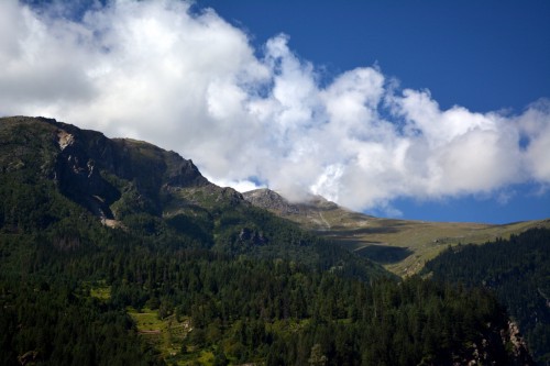
Scenic himachal road, well frequented by army vehicles & Royal Enfield bikes, really keeps you enchanted with natural beauty. We took our time to take photos & were somewhat disappointed about the so called most dangerous highway, because it was nice so far! By sunset we reached Tapri, a small riverside village and got another surprise. A traffic cop at Tapri told us that the regular road to Sangla is down because of enormous landslide & will not be available any soon. Only alternative is to take a bypass which will add 27 km more to our travel.
Bypass road is more of ‘Work In Progress’ single road, without any tar/concrete or any safety railings on the side. It was going up on the nearby hill with countless hairpin bends. When we reached up at another village on the hill it was almost night & remote peaks shining in residual sunlight were appearing like Mount Doom of LOTR. Bad road, rash driving, no sign of safety measures, unaware of where to go & no one to ask on the road, we were only going forward, forward & forward…!

Lesson : If You’re Going Through Hell, Just confirm the direction & Keep Going!
Lesson : If You’re Going Through Hell, Just confirm the direction & Keep Going!
We stopped at a junction where roads heading to three different locations, and we saw vehicle lights coming to us at some 200 meters. It was a TATA 207 small truck, we asked him Bhaiya, Sangla ka rasta? (Bro, which way goes to Sangla?).
He almost yelled at us, Don’t stop anywhere in this road. This area is of shooting stones. 3 Days before a tourist car was destroyed in landslide, no bodies are recovered yet. Go this way to Sangla & Rush now! We were already terrified, as it was darkest nights, in the remote area, with a guy as a driver to whom you do not even know for 12 hours and the only thing you know is the road on which you have to travel some unknown distance and no maps working.. Yes..! Because the bypass road is not mapped by Google or Bing!
Lesson: Anyone can be atheist in an Air-conditioned office, However when there is no other hope, you will always remember THE GOD!
Finally we reached a place which was looking like an Army / BRO camp. We asked for directions & the guy replied “its still 50 km.” It was 9.00 PM already & we have to travel on such hell-bender road for 50 more kilometers.

At one point our driver simply stopped the car at a tiny sub-road, saying Trucks are coming!
At one point our driver simply stopped the car at a tiny sub-road, saying Trucks are coming! We found an array of lights traveling towards us with a thundering sound. One after another after another atleast 30 of them, it took some good time to pass on. We were standing at a point on a landslide area, frightened with so much of noise & vibrations all around us which were sufficient enough to trigger a shooting stone making our return air-ticket useless!
Finally after many calls to our homestay owner, we reached the place almost at 10.45PM. It was Negi Cottage, Kuppa, 9 degrees outside & we preferred to have dinner. Somewhere in my mind I was rethinking about how to get out of this place without going from that disastrous Bypass road.
I was never an atheist, but I used to consider myself as a person who thinks of god scientifically, as some common origin of universe etc…etc.But that night I understood why people write all those chants, bhajans & other things.
Next morning when I got up, I realized that we are in the middle of an Apple Orchard (Kinnaur Apples are known for their quality), with a breathtaking view of valley all around us. With fresh hot Aaloo Paratha & two cups each of hot tea, in the pleasant weather was refreshing enough to fade away the memories of last night & we were ready to visit a place Chitkul – considered to be the last village on India-China border.
Road was similar to the one we traveled earlier, just the daylight made it more attractive. On the way, I asked for a direction to two guys standing roadside and then I realized even they are tourists. They shown us the way by hand & we drove on that road. Neatly arranged himachali villages, wooden houses, farms, rivers, mountains, all forms of natural beauty were all around. Snow clad mountains slowly started registering their presence.

Chitkul is the last village on china border & according to the Indian tradition to celebrate uniquness, we got a sign pointing to India’s last Dhaba (Restaurant). Unfortunately that dhaba isn’t operative anymore, but there was a hotel & lodging available next to it.
Chitkul has a temple, called Chitkul mata temple. Influenced by Tibetian style, wooden craved temple, was closed at that time. By this time, light rain had started & snowing on nearby peaks was visible. To our surprise. Two guys to whom we had asked for directions shown up at the temple. My guess was right, they were tourists too. We had a chat & got to know that they belongs to My city, PUNE. We exchanged contact & we left for lunch.


On our way to Sangla, there was a tibetian restaurant. Sangla is a peaceful village, with all basic amenities required including school, hospital & ATMs. There is also a castle/fort. We were told that car can take you halfway, but I bet its a a task for a skilled driver.

The idea of Kila (Fort) is different than our regular understanding. It’s situated on a hill top and there is a tower. The temple is located on the topmost floor of that tower. Now the access is regulated to the actual temple, but there is a Devi (Goddess) temple & one Buddha temple on the Sangla Kila – a must visit place where you can get a bird’s eye view of Sangla, Kuppa & nearby locality.

Later while discussing with Mr. P. L. Negi, local activist & ex-Serviceman, the concept of kila (Fort) was justified as the area was frequented by raiders from Nepal & Tibet. To keep temple safe, they constructed it in the tower. Mr. Negi has some good collection of local folklore, documents and information about the Sangla & nearby places.
The day ends at Sangla!
After mesmerizing trip to chitkul & spending quality time in Sangla, we headed for Kalpa, via Reckong Pio. Pio is neat city, district capital of Sangla and may be the most beautiful district capital ever in India.
Situated in the lap of Himalaya, Reckong Pio got the amazing mix of chaos of city and friendly environment of typical himachali village. In City center, mainly marked by Market and Taxi stand, our first point of contact was Mr. Raju, who has been referred to us by our Sangla host, Mr. P. L. Negi. Mr. Raju wasn’t there at his shop, but his wife is. Smiling, middle aged Himachali lady, she tried her best to give us more information about the area and possible sightseeing options. Meanwhile Mr. Raju arrived and greeted us like an old friend visiting after years. He suggested to stay at Kalpa (few kilometers ahead of Pio) for better deal and better view. We took a call to visit Kapla and finalize hotel, and come back to Pio for some shopping followed by Dinner.
Again road to Kalpa, was no less scenic, but with added toughness, hairpin bends are frequent and we actually pass through Forest Reserve. At Kalpa, we checked couple of places, finally got a real deal of resort. 600 Rs per night, with breakfast, in a valley facing room was a deal to steal. To add up the awesomeness, there was water-stream flowing exactly next to our room. Serene meadows and typical wooden house, just like coming real from some fairy tail.
Resort was otherwise empty, except a group of Europeans staying next to our room. Moody was Swiss and his friends were from Paris and Austria, friendly people.

The Day was ending, light of setting sun were covering the mountains across the valley, and suddenly we saw a golden shade, appearing across the very next peak. It was incredible. We all rushed to next balcony, and “Moody” was welcoming enough to let us catch that view. It’s like heavenly glow, covering most the mountains in the East, a sight very very special for Himalayas, while everything else, including valley are getting a thick cloud cover, peaks are glowing golden. Suddenly like a movie ends, that glow disappeared. This is how sunset in mountains is. We decided to have dinner at Pio and drove back. While seating in a good enough restaurant, we were planning about what else to be done for Nako and further more locations, suddenly a lady from next table turned to us and asked in plain Marathi (our native language), “Marathi aahat tumhi?” (Are you Maharashtrian?). She was introduced herself as Kshitija, a Maharashtrian traveler, exploring this region all alone. It was a nice casual chat with average quality dinner and we headed back to our lodging.
Day 4 of our journey was planned as a visit to Nako, which is famous for monasteries and a lake, at approx altitude of 12,000 ft. from MSL. As our Indigo car cannot drive at such high altitudes, we opted for one day hire of Mahindra Xylo.
Day 4 Nako
We left for Nako early morning, even without breakfast, as we have to head back, before shooting stone winds in the late afternoon.
Our first stop was a temple, built by Border Roads Organization, responsible for this & many more vital roads operates across the border. In such rigorous terrain, its the faith, which keeps one motivated and focused on work.

Soon the landscape changed. From lush green cover, it became barren, blank deserted stony mountains, resembling Ladakh. Green is now a rare color and one can see warning signs road side, quite often. Our new driver Giridhari lal, is a gentleman, with skilled hands and in depth knowledge of the locality. He shared his experience during a flood couple of years back. Regarding the shooting stone warning, he said, “After around 2.30 PM there starts a strong wind, which loosens up boulders uphill. That starts shooting stone on this road. It is not just landscape which makes it officially the most treacherous road of the World.”

On the we passed some military vehicles, one decorated Maruti Gypsy, which Giridhari said, “it must be a Farewell to some retiring Army Personnel”. and some routine trucks. Finally a dense green patch was visible on the far away mountain, that was the destination, NAKO village.
NAKO located around 12,000 ft from MSL, known for Buddhist temples and Nako lake, a lake at such high altitude. Village itself is not much densely populated, and signs of Buddhism are prominent throughout.

First look at Nako lake brings in almost regular shaped lake, with very high greenish tint, and not-so-impressive view overall.
Well surrounded by trees around, and some random yaks are making appearance inbetween.
Near this lake, there are four temples, attributed to saint Padmasambhava. Our visit timing was a bit mismatch, and we found the temple locked. But weather was clear, and we had some good time to roam across the lanes of NAKO.

We found a restaurant. a normal restaurant and dormitory facility, but something was different. When we asked about the contents of salad, that waiter (who is also a cook) just glanced outside, saying, there will be cabbage, reddish, and so on. Upon asking why he is looking outside, he replied, “I will harvest it from garden & make it fresh for you. You can have a small walk, in an hour, your salad & pasta will be ready.” Taken by surprise, we also glanced his kitchen. Really clean, tidy kitchen that was. and finally the food was served.
Clock was ticking, we have got some good pics all the way. We decided to head back, considering we have to reach Kalpa again. Before leaving Nako, we had one last glance at that beautiful neat and slightly modernized village.

Next Day — Exploring Kalpa in Part 3
– Vikram Kulkarni.

.jpg)


No comments:
Post a Comment
Note: Only a member of this blog may post a comment.