
https://kunalstrek.blogspot.com/2020/08/ancient-karnatak-part-2-amruteshwar.html
प्राचीन कर्नाटक - भाग २
अमृतेश्वर मंदिर, जवागलचे लक्ष्मी नरसिंह मंदिर, हळेबिडू आणि बेलूरची मंदिरे, आणि दोडागोदावलीचे लक्ष्मी मंदिर
१३ फेब्रुवारी , दुसरा दिवस
रात्री
९ वाजता आम्ही कडुरला पोहचलो. रेल्वे स्थानक पासून आम्ही हॉटेल
शोधण्यासाठी KSRTC बस आगारच्या दिशेने हॉटेल शोधत गेलो. बस आगारच्या बाहेरच
नाक्यावर, एक वातानुकूलित हॉटेलवाल्याने आम्हाला २०००-२३०० सांगितले,
म्हणून आम्ही दुसरे हॉटेल बघू लागलो. बस स्थानकाच्या समोरच, आम्हाला ७००
रुपयात चांगले Non-AC हॉटेल मिळाले. उशीर झाला होता, त्यामुळे आम्ही तसेच
सामान ठेवून बाहेर जेवायला गेलो.
अमृतेश्वर मंदिर
प्रवासाचे वर्णन:
दुसऱ्या दिवशी सकाळी ६.३० वाजता, आम्ही नाश्ता न करता तरीकेरेसाठी बस बघायला गेलो. आम्हाला अमृतेश्वर मंदिर पाहायला जायचे होते. त्यासाठी आम्हाला तरीकेरेला जाऊन पुढे अमृतपुरासाठी बस पकडायची होती. कडुर हे, बेंगळुरू ते शिवमोगा ह्या महामार्ग असल्यामुळे इथे सतत १० ते १५ मिनिटात बस येत असतात. त्यामुळे तरीकेरेमार्गे जाणाऱ्या बस हि लगेच मिळतात. आम्हाला सकाळी ६.४५ ची बस मिळाली.
कडुर ते अमृतेश्वर मंदिर अंतर ३५ किमी आहे. कडुर
बस स्थानकातून शिवमोगा, भद्रावतीला किंवा तरिकेरे वरून जाणारी कुठलीही बस
पकडावी. आणि तरीकेरेला उतरावे. कडुर ते तरीकेरे तिघांचे बस भाडे १००रु
घेतले.
तरीकेरे वरून अमृतेश्वर मंदिर अंदाजे ८ किमी वर आहे. त्यासाठी अमृतपुरासाठी तरीकेरे बस स्थानकातून दुसरी बस पकडायला लागते.
तरीकेरे
वरून, आत गावात खाजगी बस चालतात. आम्ही ७.३०ला तरीकेरेला पोहचलो. तेथे बस
स्थानकात चौकशी केल्यावर कळाले की बसला अजून उशीर आहे. तोपर्यंत आम्ही
तेथे रस्त्याला असलेल्या हॉटेल मध्ये नाश्ता केला. मेदुवडा, इडली आणि
बिशीबिळी भात खाल्ला. नाश्ता एकदम गरम आणि चवीला पण उत्तम होता. अजून काही
बस आली नव्हती. मग आम्ही तेथील रिक्षा वाल्याना विचारले. त्यांनी आम्हाला
फक्त सोडायचे २०० रुपये सांगितले. कमी करून तो १८० रुपयात तयार झाला. आम्ही
१५ मिनिटात मंदिराजवळ पोहचलो.
मुंबई वरून यायचे झाले तर कडुर, शिवमोगा किंवा हसन रेल्वे स्थानक वरणा येऊ शकता.
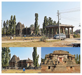
अमृतेश्वर मंदिर वर्णन:
मंदिरात
कॅमेराने फोटो काढायला देत नाही, पण मोबाईल कॅमेराने देतात. मंदिर ११९६
साली, होयसाळ राजवटीत त्याच पद्धतीत बांधले गेले आहे. मंदिराचा सभामंडपातील
खांब सुंदर प्रकारे तासून ठेवले आहेत. त्यावर आपले प्रतिबिंब ही दिसते.
तसेच मंदिराच्या गर्भ गृहात शिवाची पिंड आहे. मंदिराच्या सभामंडपात वरती
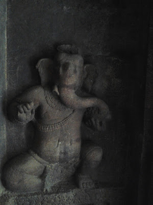
एका छतावर उच्छिष्ट गणेशची मूर्ती आहे. बाहेरील भिंतीवर खाली रामायण,
महाभारत आणि श्रीकृष्ण लीला लहान कोरीव कामात दाखवल्या आहेत. मंदिराच्या
बाहेरील सरंक्षक भिंतीवर शिल्प आणि नक्षी ठेवल्या आहेत. बाकी मंदिराचे फोटो
मी टाकले आहेत.
सकाळी ११.३० ला मंदिर बघून पुन्हा बाहेर बस साठी
वाट पाहू लागलो. पण १५-२० मिनीटांनी एक रिक्षा आली. त्यांनी आमच्या तिघांचे
६० रु शेअर भाडे घेत, पुन्हा तरीकेरे बस स्थानकात सोडले. मघाशी
सांगितल्याप्रमाणे महामार्गावर सतत बस असतात. त्यामुळे आम्हाला काही वेळातच
कडुर साठी बस मिळाली. त्याने आम्ही १ ते सव्वा एक वाजता कडुरला पोहचलो.
 |
| अमृतेश्वर मंदिर |
लक्ष्मीनरसिंह स्वामी मंदिर, जवागल:
आम्हाला
जवागलचे लक्ष्मीनरसिंह स्वामी मंदिर पहायला जायचे होते आणि तिथून
संध्याकाळ पर्यंत हळेबिडूला जायचे होते. त्यामुळे कडुरला पोहचल्यावर, आम्ही
जास्त वेळ न घालवता हॉटेल मधून सामान उचलून न जेवता, काही फळ आणि केळी
घेऊन, बस साठी गेलो.
जवागल प्रवास वर्णन:
कडुर
ते जवागल अंतर ४०-४१ किमी आहे आणि जवागल ते हळेबिडू १० किमी आहे. आम्ही
कडुर वरून प्रवास करत होतो. त्यासाठी आम्ही बस स्थानकात हळेबिडू बसची चौकशी
केली असता, कळले बसला अजून खूप वेळ आहे. त्यांनी आम्हाला बनावारा पर्यंत
जाऊन तेथून पुढे हळेबिडू मार्गे बेलूर किंवा हसनला जाणारी बस पकडायला
सांगितली. त्याप्रमाणे आम्ही बनावाराला जाऊन तेथून पुढे बेलूरला जाणारी बस
पकडली. त्यामुळे आम्ही लवकर पोहचलो. कडुर ते बनावार आमच्या तिघांचे ९०
रुपये आणि तेथून बनावार ते जवागल ७५ रुपये तिकीट घेतली.
अंदाजे
दुपारी २.१५ पर्यंत आम्ही जवागलला पोहचलो. मंदिर हे बस स्थानकापासून
पाठीमागे असलेल्या गावात आहे, चालत ८ ते १० मिनिटे लागतात. आम्ही विचारत
गेलो. वाटेत आम्हाला एका घराबाजूला प्राचीन मंदिराचे खांब दिसले. त्या
मंदिराला श्री गंगाधरेश्वर मंदिर म्हणतात पण हे मंदिर फक्त पाषाणाचे दिसत
होते. त्यावर शिल्प दिसत नव्हते. त्यामुळे आम्ही बघायला गेलो नाही.
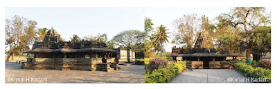
लक्ष्मीनरसिंह स्वामी मंदिराचे वर्णन :
मंदिराचे
मुख्य दैवत लक्ष्मीनरसिंह आहे. मंदिर सुंदर अश्या शिल्पांनी भरलेले आहे.
मंदिराचे मुख्य द्वार बंद होते, त्यामुळे आम्हाला आत जाता आले नाही.
मंदिराचे द्वार बहुतेक बंदच असते. सकाळी कदाचित पुजारी येत असेल तेव्हा
उघडत असेल. मंदिराबाहेरील भिंतीवर विशेष करून विष्णूची वेगवेगळी सुंदर
शिल्पे आहेत.
मंदिर बघून आम्ही हळेबिडूसाठी निघालो. आम्ही बेलावडीचे
मंदिर बघायला गेलो नाही. जवागल वरून बेलावडीचे मंदिर अंदाजे ९ किमी आहे
आणि हळेबिडू वरून ११ किमी आहे. हे मंदिर दोघांच्या मधोमध आहे. पण मुख्य
रस्त्यावरून बेलावडी गाव आत ४ ते ४.५ किमी आहे आणि तेथून पुन्हा रिक्षा
बघायला लागेल म्हणून आम्ही गेलो नाही. जवागल ते हळेबिडूसाठी आम्हाला १५ ते
२० मिनिटात बस मिळाली. तिघांचे तिकिटाचे ४५ रुपये घेतले.
 |
| जवागलचे लक्ष्मीनरसिंह स्वामी मंदिर |
हळेबिडू आणि बेलूर
हळेबिडू
आणि बेलूरला मुंबई वरून जायचा झाला तर ट्रेनने हसन जंक्शन जवळ पडेल आणि
हसन वरून बसेस बऱ्याच मिळतील आणि विमानाने म्हैसूर विमानतळ जवळ आहे.
मँगलोर विमानतळ देखील जवळ आहे पण तेथून बस किती मिळतील याची मला माहिती
नाही.
जैन बसडी आणि केदारेश्वर मंदिर
जवागल ते हळेबिडू अंतर फक्त १० किमी असल्यामूळे आम्ही १५ मिनीटात पोहचलो. संध्याकाळी सव्वा चार वाजता आम्ही हळेबिडूला पोहचलो.
हळेबिडूला
पोहचल्यावर आम्ही हॉटेल न शोधता, पहिले केदारेश्वर मंदिर आणि जैन बसडी
(मंदिर) पाहायला गेलो. हे दोन्ही मंदिर जास्त मोठी नसल्यामुळे आम्ही
संध्याकाळीच बघायचे ठरवले.
पहिले जैन बसडी बघायला गेलो. जैन बसडी हि
खूप सुंदर आहे. ह्या मंदिराचे खांब इतके सुंदर तासून ठेवले आहेत, त्यामुळे
ते सुंदर चकाकतात. आम्ही १० मिनिटात जैन बसडी पाहून केदारेश्वर मंदिर
बघायला गेलो.
केदारेश्वर मंदिरात पोहचेपर्यंत ४. ५५ झाले होते. त्यामुळे
मंदिर बंद होण्याची वेळ झाली होती. हे मंदिर बहुतेक साडेपाचला बंद होते.
कारण साडेपाचला तेथील कर्मचारीने आम्हाला बाहेर जायला सांगितले. बहुतेक
आम्ही उशिरा गेल्यामुळे मंदिराच द्वार बंद होते. आम्ही त्या कर्मचाऱ्याला
विचारले तो बोलला मंदिर बंदच असते. का जाणो पण मला त्याच्या बोलण्यावर
विश्वास नाही बसला, पण खरेच द्वार उघडत सुद्धा नसतील.
 |
जैन बसडी
|
 |
केदारेश्वर मंदिर
|
कल्याणी/पुष्कर्णी:
दोन्ही
मंदिरे पाहून आम्ही साडेपाचला कल्याणी/पुष्कर्णी बघायला गेलो. इथे
पुष्कर्णीला कल्याणी म्हणतात. केदारेश्वर मंदिरापासून ३ किमी अंतरावर आहे
तिथे आम्ही चालतच गेलो. कल्याणी ज्या गावात आहे, त्या गावाच नाव हेलिकेरे.
हळेबिडू वरून एक रास्ता हगरेसाठी रस्ता जातो, त्या दिशेला जायला लागते.
मंदिराजवळून चालत आल्यावर रस्त्याला साधारण १.८ ते २ किमी वर सिद्धपुरा गाव
लागते. तेथून एक रस्ता आत कल्याणीला जातो. गाववाल्यांना विचारले कि ते
रस्ता सांगतात. फाट्यावरून कल्याणी आत साधारण १.२ किमी आहे.
आम्ही ह्या फाट्यापर्यंत चालत गेलो. नंतर आम्हाला तेथील एक रिक्षावाला भेटला, त्याने आम्हाला फुकट सोडले.
नाही
तर आम्हाला अजून २०/२५ मिनिटे लागली असती. मग नंतर त्याच रिक्षावाल्याला
७० रुपये देऊन आम्हाला हळेबिडूला सोडायला सांगितले. सव्वा सहाला आम्ही
कल्याणी जवळ पोहचलो.
कल्याणी मध्ये पाणी नव्हते. तेथे काही वीरगळ हि ठेवल्या आहेत. मी ह्या कल्याणीचे फोटो टाकले आहेत.
कल्याणीला जाण्यासाठी काही सूचना:
आम्ही
हळेबिडू बस स्थानकातून रिक्षा केली असती तर, आम्हाला बरे पडले असते. पण
आम्ही पुढे आलो असल्यामुळे चालू लागलो. रस्त्यात मोजक्याच रिक्षा गेल्या पण
त्या हि भरलेल्या होत्या. पण त्या रिक्षाने आम्हाला सिद्धपुराला उतरायला
लागले असते, तरी पुन्हा आत चालायला लागले असते, त्यापेक्षा हळेबिडू वरून
येऊन जाऊन एक रिक्षा ठरवून जावे.
  |
कल्याणी आणि बाजूचा फोटोत तेथे असलेले शिल्प आणि वीरगळ
|
हॉटेलचा शोध:
हळेबिडूला
पोहचल्यावर आम्ही राहण्यासाठी निवारा शोधू लागलो. इथे खूपच कमी हॉटेल
आहेत. त्यामुळे कुठलेही भेटेल त्यात राहायला लागते. आम्ही १००० रुपये देऊन
एक हॉटेल मध्ये राहिलो. पैशाच्या मानाने हॉटेल एकदमच ठीक होते. पण पर्याय
ही नव्हते. सागर ह्या आधी आला होता तेव्हा तो ह्याच हॉटेल मध्ये राहिला
होता.
त्यापेक्षा बेलूरला जाऊन रहावे आणि इथे मंदिर बघून पुन्हा जावे.
बेलूरला हि जास्त हॉटेल दिसत नाही तरी पण आम्हाला १/२ चांगली हॉटेल दिसली.
१४ फेब्रुवारी
होयसळेश्वराच मंदिर:
दुसऱ्या
दिवशी सकाळी ७ ला नाश्ता करून, आम्ही होयसळेश्वराचे मंदिर बघायला गेलो.
मंदिराचे वर्णन करायला, मला तेवढे ज्ञान ही नाही आणि थोडे फार केले तर खूप
लांब होईल, त्यामुळे मी त्यांचे वर्णन करत नाही. पण ऐवढे नक्की मंदिराच्या
बाहेरील प्रदक्षिणा मार्गावरील आणि मंदिरातील आतील शिल्प बघून मन भरत नाही.
मंदिर परिसरातच शेजारी संग्रहालय आहे. शुक्रवारी संग्रहालय बंद असते आणि
आम्ही गेलो तो नेमका शुक्रवार होता. जास्त करून मुर्त्या बाहेर उघड्यावरच
ठेवल्या आहेत. त्या जागेला बाजूने पूर्ण तारेचे कुंपण होते त्यामुळे काही
मुर्त्या लांबून बघता आल्या.
 |
होयसलेश्वर मंदिर आणि खालील फोटो संग्रहालयातील मूर्ती
|
योगनरसिंह मंदिर, नरासिपुरा (Narasipura) :
ते
बघून आम्ही योगनरसिंहाचे मंदिर बघायला गेलो. हे मंदिर हळेबिडू बस
स्थानकापासून २.५ किमी वर आहे. त्यासाठी आम्ही रिक्षा करून गेलो. रिक्षाने
आमचे १०० रु घेतले. रिक्षावाल्याला माहित नसेल तर (गुगल मॅपनुसार)
नरासिपुरा म्हणून गावाकडे जाणाऱ्या वाटेत आहे सांगा. पण गुगलमॅप वर
जवळपासचे अजून दोन नरासिपुरा दाखवतात. त्यामुळे नीट चेक करायला लागते.
मंदिर लहानच आहे, तसेच मंदिराच्या भिंतीवर जास्त शिल्प नाहीत. मंदिराचा
दरवाजा बंद होता, त्यामुळे आम्हाला आत जाता आले नाही. बहुतेक इथे जास्त
कोणी येत-जात नाही, हे तिथे गेल्यावर कळून येते. दहा ते पंधरा मिनिटात
मंदिर बघून आम्ही निघालो. निघते वेळी, गावातून दोघातिघांना घेऊन रिक्षा येत
होती. त्यांनी आम्ही तिघांचे शेअर पद्धतीने ३० रुपये घेऊन हळेबिडूला
सोडले. इथेही तुम्ही हळेबिडू स्थानकातून येण्याजाण्यासाठी रिक्षा ठरवून येऊ
शकता. अन्यथा परतीचा वेळी रिक्षा भेटली तर मुख्य रस्त्यापर्यंत दोन किमी
पायपीट करायला लागेल.

बेलूरला चेन्नकेशवा मंदिर:
अकरा
वाजता, तेथून आम्ही सामान घेऊन बेलूरला चेन्नकेश्वराचे मंदिर बघायला
निघालो. १० ते १५ मिनिटात आम्हाला बेलूरसाठी बस भेटली. हळेबिडू ते बेलूर
अंतर १६ किमी आहे. आम्हाला बसने २० मिनिटे लागली. पाऊणे बारा वाजता आम्ही
बेलूरला पोहचलो आणि पहिलं जेवून घेतले.
मंदिराच्या बाहेर सामान
ठेवण्यासाठी दुकान आहे, तेथे तिघांचे सामान ३०रु देऊन ठेवले. बेलूरच्या
मंदिरात मला एक गोष्ट विशिष्ट आवडली ती म्हणजे ह्या मंदिरात DSLR कॅमेरा पण
वापरू शकतो. फक्त गर्भ गाभाऱ्यातील देवाच्या मूर्तीचा फोटो काढायला देत
नाही. तीन-एक तास आम्ही मंदिर बघत होतो. मंदिरातील देवांच्या मूर्ती आणि
सुरसुंदरीच्या मूर्ती खूपच सुंदर कलाकृती वाटत होत्या.
 |
बेलूरचं चेन्नकेशवा
|

डोड्डागड्डावली लक्ष्मी मंदिर :
मंदिरपर्यंतचे प्रवास वर्णन
मंदिर
बघून आम्ही डोड्डागड्डावली (DODDAGADDAVALLI) , हगरे (HAGARE) जवळील
लक्ष्मी मंदिर पाहण्यासाठी निघालो. त्यासाठी आम्ही पुन्हा बेलूर बस स्थानक
मधून हगरेला जाण्यासाठी हसनची गाडी पकडली. बेलूर ते हगरे अंतर १६ किमी आणि
मूलनहळ्ळी पर्यंत २० किमी आहे. जर तुम्ही हसन वरून आलात तर, हसन ते
डोड्डागड्डावली २१ किमी आहे. आणि हसन ते हगरे २३ किमी आहे.
आम्ही १५ ते २० मिनिटात बसने हगरेला पोहचलो. येथील लोक डोड्डागड्डावलीला, "गडूवल्ली" पण म्हणतात
हगरे
वरून मूलनहळ्ळी मार्गे लक्ष्मी मंदिर ७.५ किमी आत आहे. आणि मूलनहळ्ळी वरून
३.५ किमी वर आहे. पण मूलनहळ्ळी वरून आम्हाला रिक्षा भेटेल कि नाही, म्हणून
आम्ही हगरेला उतरलो. पण माझ्या मते आम्ही योग्यच केले. तेथून आम्ही
येऊन-जाऊन २४० रुपयात रिक्षा ठरवली. पण रिक्षावाल्याने आम्हाला हगरेचा पुढे
मधूनच एका गावातून घेऊन गेला. गुगल नकाशावर त्या गावाच नाव ब्यद्रहली
(Bydrahalli) दाखवत आहे. ह्या रस्त्याने अंतर
४.५ किमी आहे. रस्ता मध्ये-मध्ये एकदमच खराब होता.
मंदिर वर्णन:
मंदिर
होयसळा राजवटीतील राजाने १११४ मध्ये बांधले. ह्या मंदिराचे शिखर ईतर
मंदिरासारखे दिसत नाही. तसेच मंदिराच्या बाहेरील भिंतीवर फक्त दरवाजाचे
द्वारपाल सोडले तर एकही शिल्प दिसत नाही. मंदिरात लक्ष्मीची मूर्ती आणि
चामुंडा/चण्डिकेची मूर्ती आहे. चामुंडा/ चंडिका देवीच्या समोरील गर्भ
गुर्हात लहानशी महादेवाची मूर्ती आहे. पण ती मूर्ती त्यावर वेगळी आणून
ठेवलेली दिसते, कारण त्याच्या जोत्यावर गरुडाचे शिल्प आहे, यावरून तिथे
श्रीविष्णू ची मूर्ती असावी असे वाटते.
ह्या चंडिका देवीच्या गर्भ
गृहाचा बाहेर साधारण ७ ते ८ फुटाचे दोन सांगाड्यातील भूत किंवा वेताळ आहेत.
ह्या भुतांच्या सांगाड्याला खाली एक होल दाखवला आहे. असे म्हणतात हे भूत
तेथून श्वास घेतात. हे आम्हाला तेथील पुजारी आणि ASI चा माणूस दोघे मिळून
आम्हाला मध्ये-मध्ये मंदिरा बद्दल सांगत होते. मंदिराच्या आत फोटो काढायला
देत नाही, तरी पण आम्ही गोड बोलून काढून घेतले.
 |
दोड्डागुड्डावल्ली लक्ष्मी मंदिर
|
पुढील भागात १५ फेब्रुवारीचा प्रवास
मंदिर
पाहून आम्ही पुन्हा हागरेला येऊन हसनला गेलो. कारण आम्हाला उद्याच्या
दिवसात अरसिकेरेच ईश्वरा मंदिर, हरणहल्लीचे श्री लक्ष्मीनरसिंह स्वामी
मंदिर आणि सोमेश्वरा मंदिरानंतर तेथून तुरुवेकेरेच चन्नकेश्वरा आणि
मुलेशंकरेश्वरा मंदिर आणि शेवटी अरलगुप्पेचा चेन्नाकेशवा आणि श्री
कल्लेश्वरा मंदिर करायची योजना होती.
ह्या योजनेचा प्रवास अनुभव मी, प्राचीन कर्नाटक ३ ब्लॉग मध्ये लिहिला आहे. त्याची दुआ/ साखळी खाली दिली आहे.
https://kunalstrek.blogspot.com/2020/08/ancient-karnatak-part-3-ariskere.html
प्राचीन कर्नाटक- भाग ३
अरसिकेरे , हरणहल्ली, तुरुवेकेरे
आणि अरलगुप्पेची मंदिरे
भाग
दोन मध्ये मी हळेबिडू, बेलूर आणि दोड्डागोड्डवल्लीचा मंदिरांचे प्रवास
वर्णन लिहिले. ह्या भागात त्याच्या दुसऱ्या दिवशी म्हणजे १६ फेब्रुवारीला
अरसिकेरेचे ईश्वरा मंदिर, हरणहल्लीचे चन्नकेशवा आणि सोमेश्वरा मंदिर,
तुरुवेकेरेची श्री चन्नकेशवा, मुले शंकरेश्वरा मंदिर आणि अरलगुप्पेची
चेन्नकेशवा आणि श्री कल्लेश्वराचे मंदिराच्या प्रवास वर्णन बद्दल लिहिले
आहे.
ह्या मंदिरासाठी तुम्ही मुंबई वरून अरसिकेरे जंक्शन किंवा
तिपटुर जंक्शनला उतरून येऊ शकता, हसन जंक्शन ला पण उतरू शकता, पण ते ८७
किमी लांब आहे. पण फक्त हि मंदिर करायची असतील तर, तिपटुर मधोमध येते
त्यामुळे जास्त सोयीचे पडू शकते.
अरसिकेरे आणि हरणहल्लीचे मंदिर
अरसिकेरे प्रवास वर्णन :
दोड्डागोड्डवल्लीचे
मंदिर बघून, आम्ही पुन्हा हगरेला आलो, आणि हसनला जाणारी बस पकडली. कारण
आम्हाला रात्री रहायला अरसिकेरेला जायचे होते. दुसऱ्या दिवशी आम्हाला
अरसिकेरे आणि हरणहल्लीची मंदिरे पहायची होती.
आम्ही हगरे वरून पण
पुन्हा हळेबिडू-बाणावारा वरून अरसिकेरेला ४५ किमीचे अंतर बस बदलत जाऊ शकत
होतो. पण हळेबिडू वरून आम्हाला मोजक्या आणि वेळेत बस होत्या. त्यात आमचा
वेळ गेला असता आणि मुख्य म्हणजे संध्याकाळचे सहा वाजून गेले होते. हसन हे
मुख्य शहर आहे. तेथून कर्नाटकात जाणाऱ्या आणि बाहेर जाणाऱ्या अनेक गाड्या
सुटतात. त्यामुळे आम्ही तेथे गेलो. तो योग्य पर्याय आम्ही निवडला. कारण
आम्ही तिथे पोहचल्यावर बाजूलाच अरसिकेरेसाठी गाडी लागली होती.
हगरे ते हसन २३ किमी आणि हसन ते अरसिकेरे अंतर ४४.५ किमी, असे आम्ही ६७.५ किमीचा एकूण दोन तासाचा प्रवास केला.
अरसिकेरेला
आम्हाला हॉटेल शोधायला जास्त त्रास झाला नाही. बस स्थानकाच्या बाहेरच
आम्हाला हॉटेल मिळाले. कोणी तरी दुसऱ्या दिवशी लग्नासाठी तेथील ३/४
वातानुकूलित हॉटेल रूम्स आरक्षित करून ठेवल्या होत्या. तरी त्यातील एकाने
(रवी रेसिडेन्सी हॉटेल) आम्ही दुपारी १ वाजेपर्यंत निघून जाऊ सांगितल्या
मुळे, तिघांसाठी ९५० रुपयात एक रात्री साठी फॅमिली रम दिली, हॉटेल ही
चांगले होते.
चन्नकेशवा (श्री लक्ष्मीनरसिंह स्वामी मंदिर) आणि सोमेश्वरा मंदिर हरणहल्ली
प्रवास वर्णन
सकाळी
७ ला उठून आम्ही हरनहल्लीचे चन्नकेशवा (श्री लक्ष्मीनरसिंह स्वामी मंदिर)
आणि सोमेश्वरा हे दोन प्राचीन मंदिरे बघायला गेलो. त्यासाठी अरसिकेरे वरून
हसनला जाणारी किंवा त्यादिशेला जाणारी बस पकडावी. अरसिकेरे वरून हरनहल्ली
अंतर ८.८ किमी आहे. बस भाडे प्रत्येकी १५ रुपये घेतले. आम्ही १० मिनिटात
तेथे पोहचलो. बहुतेक इथे शेअर वडाप/ टमटम पण चालतात, कारण येतेवेळी आम्ही
शेअर वडाप /टमटम रिक्षाने प्रत्येकी १० रुपयात आलो.
तिथे पोहचल्यावर
आम्ही पहिली चहा पिऊन घेतली. रस्त्याला उतरल्यावर आपल्याला दोन्ही बाजूला
गावात जाणारा रस्ता दिसतो. रस्त्याच्या पलीकडे चन्नकेशवा मंदिर आणि ह्या
बाजूला सोमेश्वरा मंदिरकडे आहे. दोन्ही मंदिर ५ मिनिटात चालत पोहचतो.
दोन्ही मंदिरे तेराव्या शतकात होयसळा राजवटीत बांधले गेले आहेत. त्यामुळे तीच शैली आपल्याला दिसते.
चन्नकेशवा मंदिर (श्री लक्ष्मीनरसिंह स्वामी)
दोन्ही
मंदिरे बंद असतात, त्यामुळे फक्त बाहेरूनच बघायला मिळतात. चन्नकेशवा (श्री
लक्ष्मीनरसिंह स्वामी) मंदिर मध्ये सकाळी पुजारी पूजा करायला येतो,
त्यावेळी ५ ते १० मिनिटासाठी दरवाजा उघडतो. त्यामुळे मंदिराचा आत जायला
मिळते. आम्ही नेमके त्यावेळीच पोहचलो होतो, त्यामुळे आम्हाला आतील मूर्ती
बघता आली. पण पुजारी आतून फोटो काढायला देत नाही, फक्त बाहेरूनच परवानगी
देतो. मंदिर परिसराला बाहेरून भिंत घातली असल्यामुळे, जर बाहेरील मुख्य
दरवाजा बंद असेल, तर मंदिर बाहेरून हि बघता येणार नाही. मंदिराचा दरवाजा
किवा भिंतीवर वेळेचा फलक नव्हता. त्यामुळे पुजारी गेल्यानंतर मंदिर बंदच
असते.
आम्हाला पुजारी बोलला मंदिर
चालू असते. पण आम्ही दुसरा मंदीर बघून पुन्हा येवुन बघितले असता मंदिर बंदच
होते. त्यामुळे मंदिर बघण्यासाठी पुजारीच्या वेळेत जावे अन्यथा बहुतेक
तुम्हाला गावात त्याला शोधण्याची खटपट करावी लागेल. तरीपण तो भेटेल कि नाही
किंवा तयार होईल कि नाही, काही सांगता येत नाही.
 |
| चन्नकेशवा मंदिर (श्री लक्ष्मीनरसिंह स्वामी) |
सोमेश्वरा मंदिर
आम्ही
निघालो तसे पुजारीने बाहेरील मुख्य दरवाजा बंद करून गेला आणि मग आम्ही
सोमेश्वरा मंदिर पाहायला गेलो. ह्या मंदिर परिसराला पण लोखंडी जाळीचे
कुंपण आहे आणि बाहेर मुख्य द्वार. आम्ही गेलो तेव्हा दरवाजाला टाळे होते,
पण बाजूला जागा होती तेथून आम्ही प्रवेश केला. हे मंदिर ASI कडून बहुतेक
नीट काळजी घेत नसावे. कारण चन्नकेशवा मंदिर परिसरात जसा बाग-बगीचा केला
आहे, तसे इथे दिसत नाही.
मंदिर बंद असल्यामुळे, बाहेरूनच बघून पुन्हा अरसिकेरे साठी निघालो.
 |
| सोमेश्वरा मंदिर |
ईश्वरा मंदिर, अरसिकेरे
अरसिकेरेला
आम्ही नाश्ता करून, ईश्वरा मंदिर बघायला गेलो. मंदिर बस आगार पासून अंदाजे
१ किमीवर आहे, त्यामुळे आम्ही चालत गेलो. १५ मिनिटात आम्ही तिथे पोहचलो.
ह्या मंदिराच्या सुद्धा आतील फोटो काढायला देत नाही. मंदिर परिसर ASI ने
सुंदर ठेवले आहे. तसेच मंदिर परिसरात काही वीरगळ आणि शिलालेख पण ठेवले
आहेत.
मंदिर बघून आम्ही पुन्हा जाते वेळी मंदिरा पासून काही अंतरावर
वाटेतच, एक प्राचीन जैन मंदिर लागते ते बघायला गेलो. ह्या मंदिराला कळस
नाही आहे. त्यामुळे कळून येत नाही. पण मंदिराच्या समोरच काही शिलालेख,
मंदिराच्या कळसाचा भाग ठेवला आहे. त्याचा बाजूलाच विष्णूची एक प्राचीन ३/४
फुटाची मूर्ती हि आहे. हे मंदिर ASI च्या अखत्यारीत आहे का नाही माहित
नाही. कारण त्या मंदिर परिसरात राहणारी लोक देखभाल करत होते. बरं कां
ह्याला पण टाळे लावले होते.
 |
ईश्वरा मंदिर
|
तुरुवेकेरेचे चन्नकेश्वा मंदिर, मुले शंकरेश्वरा
आणि श्रीगंगाधेश्वरा मंदिर
अरसिकेरे -तिपटूर- तुरुवेकेरे प्रवास वर्णन:
अरसिकेरे
वरून आम्हाला अरलगुप्पेला किंवा तूरुवेकेरेला जायचे होते. पण त्या दोन्ही
साठी इथून आम्हाला थेट बस भेटली नाही, बहुतेक ठराविक वेळेत बस असतील.
त्यासाठी आम्ही बारा वाजता तिपटूर साठी बस पकडली. आणि तिपटूरला गेलो.
अरसिकेरे ते तिपटुर २६ किमी आहे त्यासाठी अर्धा तास लागतो. आणि तिपटूर ते
तुरुवेकेरे, तुरुवेकेरे रोड ने अंतर २७ किमी आहे आणि त्यासाठी पाऊण तास
लागतो.
आम्ही पहिले अरलगुप्पेला जाऊन नंतर
तुरुवेकेरेला जाणार होतो. पण अरलगुप्पेसाठी गाडीला बराच वेळ होता आणि
दुपारचे पाऊणे एक वाजले होते, मग आम्ही जास्त वेळ वाया न घालविता
तुरुवेकेरेची बस लवकर असल्यामुळे आम्ही तिथे पहिले गेलो.
टीपटूर
स्थानकातील कर्मचारी कन्नडच जास्त बोलत असल्यामुळे, बस बद्दल हिंदी मधून
विचारले असता. ते कन्नड मधूनच जास्त सांगत होते. त्यामुळे नीट समजत ही
नव्हते. एकाने थोडे हिंदीत सांगितले, मग आम्हाला कळाले की अरलगुप्पेसाठी
गाडीला बराच वेळ आहे.
सचिनला थोडी कन्नड भाषा वाचता येत असल्यामुळे तो गाडीची नावे वाचायचा. मग आम्ही वाहक किंवा चालकला
जाते का विचारून गाडीत बसायचो. त्याच्यामुळे आम्हाला पुर्ण भ्रमंतीत बराच फायदा झाला
तुरुविकेरे मध्ये होयसाळा राजवटीतील ३ लहान मंदिरे आहेत. चन्नकेश्वा मंदिर, मुले शंकरेश्वरा आणि श्रीगंगाधेश्वरा मंदिर.
आम्ही
आधीच गुगल मॅपवर मंदिर पहिले होते. त्यामुळे आम्ही तुरुवेकेरे बस स्थानकात
न जाता बस जेथे स्थानकात जायला वळते, तिथे आम्ही बाहेर उतरलो. त्यामुळे
आमचं ५ मिनिटाचे चालणे वाचले.
चन्नकेश्वा मंदिर:
१०
मिनिटात आम्ही चन्नकेश्वा मंदिर जवळ पोहचलो. इतर प्राचीन मंदिराच्या
तुलनेत हे मंदिर खूपच लहान आहे आणि मंदिराच्या बाहेरील भिंतीवर आणि कळसावर
एकही शिल्प नाही. फक्त पाषणाचे मंदिर आहे. मंदिराच्या मुख्य दरवाजाला टाळे
होते. तेथे पुजाऱ्याचा नंबर दिला होता. आम्हाला शेजाऱ्यांनी
सांगितल्याप्रमाणे, आम्ही त्यांना संपर्क केला परंतु त्यांचे कोणी तरी
इस्पितळात भरती असल्यामुळे येऊ शकत नाही असे सांगितले. मग काय, आम्ही लगेच
निघालो, कारण बाहेरून बघण्यासारखे असे काही नव्हते.
तिथून
आम्ही सरळ मुळेशंकरेश्वरा मंदिर बघायला निघालो. पण त्या मंदिराकडे
जातेवेळी, आम्हाला रस्त्याचा बाजूला एक प्राचीन मंदिरसारखे कळस दिसले. हे
अगदी चन्नकेश्वा मंदिराच्या काही अंतरावरच आहे म्हणून आम्ही बघायला गेलो.
 |
| चन्नकेश्वा मंदिर , तुरुवेकेरे |

गंगाधरेश्र्वर मंदिर:
हे
गंगाधरेश्र्वर मंदिर होते. रस्त्याला असलेला मुख्य दरवाजा बंद होता.
म्हणून आम्ही बाजूला असलेल्या गल्लीत गेलो. मंदिर परिसराच्या बांधाच्या
भिंतीला लहान दरवाजा उघडा होता. तिथून आम्ही आत गेलो. इथून आम्ही
मंदिराच्या मागच्या बाजूने गेलो.
मंदिर सध्याच्या नेहमीच्या मंदिरासारखे दिसत होते .
मंदिराच्या एका बाजूचा दरवाजाच्या बाहेरील मंडपाच्या खांबावर काही शिल्पे आणि एक शिव भक्ताची
कथा
दिसत होती आणि त्या मंडपाच्या आतील कळसाला एक भली मोठी, साधारण ३ ते ४ फूट
उंच आणि २/३ फूट रुंद अखंड दगडाची घंटा आहे. ते पाहून आम्ही मंदिराचा
मुख्य गाभराच्या दरवाजा जवळ पोहचलो. ह्या मंदिराचा दरवाजा पण बंद होता. पण
मंदिराच्या समोर दगडी खांबाचे मोठे मंडप आहे, त्यात समोर मोठा नंदी आहे.
साधारण १० फूट रुंद आणि उंच, जर मुख्य दरवाजाने मंदिरात आलो तर पहिला आपण
ह्या मंडपातून नंदीचे दर्शन घेऊन मंदिरात जाऊ. मंदिरात प्रवेश केल्यावर
नंदीच्या अगोदर दरवाजाच्या डाव्या बाजूला अजून एक खोली लागते. बहुतेक तिथे
ही प्राचीन अथवा नवीन मुर्ती असावी पण त्याचा ही दरवाजा बंद होता.
जातेवेळी आम्ही मुख्य दरवाजाच्या फटीतून बाहेर पडलो.
तेथून बाहेर पडल्यावर डावीकडे चन्नाकेश्र्वरा मंदिर दिसते आणि उजवीकडे रस्त्याला काही पावले चालल्यावर
डावीकडे मुळेशंकरेश्वरा मंदिराकडे एक वाट जाते, अगदी ५ मिनिटात आम्ही तेथे पोहचलो.
 |
गंगाधरेश्वर मंदिर,तुरुवेकेरे. ह्या फोटो मध्ये दगडाची घंटेचा एक फोटो आहे.
|
मुळेशंकरेश्वरा मंदिर:
हे मंदिर प्राचीन पण मध्यम आकाराचे आहे. ह्या मंदिराच्या भिंतीवर ही एकही शिल्प दिसत नाही.
मंदिराच्या
परिसराला बांध आणि लोखंडी दरवाजा आहे. तो बंद असल्यामुळे आम्हाला मंदिर
परिसरात ही जाता आले नाही. आणि बांधाची भिंत थोडी उंच असल्यामुळे आम्ही
बाहेरूनच गेलो.
तीनही मंदिर बंद असल्यामुळे लगेच पाहून झाली.
 |
मुले शंकरेश्वरा मंदिर, तुरुवेकेरे
|
अरलगुप्पेचा चेन्नकेशवा आणि श्री कल्लेश्वरा मंदिर
आम्हाला आता अरलगुप्पेचा (Aralguppe) चेन्नकेशवा आणि श्री कल्लेश्वरा मंदिर बघायला जायचे होते, त्यासाठी आम्ही बस बघायला गेलो.
प्रवास वर्णन
तुरुवेकेरे वरून अरळगुप्पेसाठी थेट बस नाही आणि तिपटूर ते अरळगुप्पे ठराविक आणि वेळेत बसेस आहेत.
तिपटूर
ते अरळगुप्पे आतील गावातून रस्त्याने २० किमी, तिपटूरला परत जातेवेळी आमची
बस ह्या मार्गाने गेली, आम्हाला अर्धा तास लागला आणि
टीपटूर-टुमकुरू-बेंगळुरू महामार्गावरून बिळिगेरे (बिळिगेरे) वरून २५ किमी
आहे.
तुरुवेकेरे ते अरलगुप्पे (एन मंचेना हल्ली/न.मंचेना हल्ली
रस्त्याने ) अंतर १४ किमी आहे आणि तुरुवेकेरे ते अरलगुप्पे वाया बंसन्द्रा
(Banasandra ) फाटा अंतर १८ किमी आहे साधारण अर्धा तास लागतो. तुरुवेकेरे
वरून अरलगुप्पेसाठी थेट बस नव्हती मग आम्ही किबानहळ्ळी (Kibbanhalli cross)
वरून जाणारी हुलीयारची (Huliyar ) बस पकडून बंसन्द्रा गावात उतरलो.
तुरुवेकेरे
ते बंसन्द्रा अंतर 12 किमी असून, हा राष्ट्रीय महामार्ग १५०अ असल्यामुळे
आम्ही १० मिनिटात पोहचलो. तेथून पुढे बंसन्द्रा ते अरळगुप्पे अंतर ६.४ किमी
आहे. त्यासाठी आम्ही फक्त तेथे जाण्यासाठी १५० रुपये देऊन रिक्षा केली.
चेन्नकेशवा मंदिर:
चार
वाजता आम्ही चेन्नकेशवा मंदिरात पोहचलो. हे मंदिर होयसाळा कालखंडात इसवीसन
१२५० मधील आहे. मंदिरात विष्णूची मूर्ती आहे. पण इथे ही मंदिराच्या आत
फोटो काढायला देत नाही (मोबाईलने पण) आणि मंदिरात लाईट पण नव्हती. त्यामुळे
चोरून लपून काढायचे झाले तर मोबाईलने चांगले येतील. मंदिरातील मुख्य दैवत
श्रीविष्णु आहे.
मंदिराच्या मागच्या बाजूचा चौथरा अर्ध चांदणीच्या
आकाराचा आहे. मंदिराच्या बाहेरील शिल्प ही सुंदर आहेत. मंदिर बघून आम्ही
तेथूनच जवळच असलेल्या श्री कल्लेश्वरा मंदिर बघायला गेलो. अगदी पाच मिनिटात
चालत आम्ही तेथे पोहचलो.
 |
चेन्नकेशवा मंदिर, अरलगुप्पे
|
श्री कल्लेश्वरा मंदिर
हे
शिवाचे मंदिर नवव्या शतकातील असून, नोलांबा राजशाहीतील आहे (असे
विकिपीडिया वर आहे). मंदिर बहुतेक रंगवल्यामुळे नवीनच बांधकाम केल्यासारखे
वाटत होते. मंदिराचं बांधकाम होयसाळ राजवटीतील नसल्यामुळे मंदिराच्या
बाहेरील भिंतीवर शिल्प न दिसता, सध्याचा काळातील मंदिरासारखी भिंती दिसतात.
आम्हाला फक्त मंदिराची द्वार शाखा नक्षीदार दिसली. मंदिराचे द्वार बंद
असल्यामुळे, आम्हाला आत जाता आले नाही. मंदिराच्या मंडपाला लागून अजून दोन
लहान देवडी सारखी मंदिरे आहेत. त्यात काही प्राचीन मुर्त्या आहेत. पण
त्याला ही टाळे असल्यामुळे, नीट पाहता आले नाही. तरीही दरवाजाच्या फटीतून
जेवढे दिसत होते त्यातून आम्ही पाहिले.
मंदिर परिसरात काही वीरगळ आहेत, तसेच मंदिराच्या बाजूला तळे आहे. १५ ते २० मिनिटात आमचा हे मंदिर बघून झाले.
 |
श्री कल्लेश्वरा मंदिर, अरलगुप्पे
|
अरलगुप्पे ते तिपटूर प्रवास वर्णन
आम्हाला
तिपटूरला जायचे होते. त्यासाठी गावातून ४.४५ किंवा ५.०० ची शेवटची तिपटूर
बस होती. हि बस तिपटूर वरून येते आणि तशीच लगेच पुन्हा जाते. बस जरा उशिरा
म्हणजे ५.२० ला आली. वर सांगितल्या प्रमाणे ही बस आतील रस्त्याने गेली.
आम्ही संध्याकाळी सव्वा सहा पर्यंत तिपटूरला पोहोचलॊ.
तिपटूरला बस
स्थानकाच्या आधी १ ते १.५ किमी अंतरावर तलावाच्या बाजूला एक नवीन पुष्कर्णी
सारखा छोटा तलाव आहे. त्याच्याच जवळपास पलीकडील रस्त्याला, मंदिर
परिसराजवळ रस्त्यालाच ४-५ विरगळी उघड्यावर ठेवलेल्या दिसतात, आम्ही ते
पाहून हॉटेल मध्ये नाश्ता करायला गेलो.
पुढील भागात
अशा
प्रकारे आमचा दिवस इथे संपला. तिपटूर वरून आमची रात्री १०.३०ची हुबली साठी
ट्रेन होती. कारण उद्या १७ फेब्रुवारीला आमचा गंजगट्टीची अश्टदिगपाल चौकट,
हंगलचे तारकेश्र्वर मंदिर आणि सिरसीचे सहस्त्रलिंग करायची योजना होती.
ह्या प्रवासाचा अनुभव कर्नाटक भाग ४ मध्ये लिहीला आहे.
प्राचीन कर्नाटक - ४
गंजगट्टीचा अष्टदिगपाल चौकट , हंगलचे तारकेश्वर मंदिर आणि सिरसीचा सहस्रलिंग
तिपटूर
वरून हुबळीसाठी रात्री ११.३० ची ट्रेन होती. त्या ट्रेनने आम्ही १६
फेब्रुवारीला सकाळी ५.३० ला हुबळीला पोहचलो. ह्या आजच्या दिवसात आम्ही
गंजीगट्टीची (Ganjigatti) (शिग्गाव (Shiggaon) जवळील) अष्टदिगपाल चौकट,
तेथून आम्ही सिरसीचा (Sirsi) सहस्रलिंग आणि बनावासीचा (Banavasi)
मधुकेश्वरा मंदिर पाहून वस्तीला शिराळकोप्पाला जाणार होते. वेळे अभावी आमचे
बनावासीचा मंदिर राहून गेले.
गंजगट्टीचा अष्टदिगपाल चौकट:
प्रवास वर्णन
१६
फेब्रुवारीला आम्ही सकाळी ५.३० ला हुबळीला पोहचलो. योजने नुसार आम्हाला
शिग्गाव (shiggaon) येथील गंजीगट्टीला जायचा होते. (विशेष सूचना: गंजीगट्टी
गुगलमॅपवर शोधले असता हुबळी जवळील अजून एक गंजीगट्टी दाखवते. त्यामुळे
शिग्गाव शोधून तेथील गंजीगट्टी शोधायला लागते). आम्ही रेल्वे स्थानकवरून
रिक्षाला ९० रुपये भाडे देऊन, हुबळी बस आगार मध्ये पोहचलो. तिथून आम्हाला
सकाळी ६ ची बंगळुरूला जाणारी बस भेटली. त्यांनी आम्ही शिग्गाव (Shiggaon)
उतरलो. हुबळी ते शिगाव अंतर ४४ किमी आहे आणि शिग्गाव ते गंजीगट्टी अंतर ४
किमी आहे. आम्ही तासाभरात शिग्गावला पोहचलो.
नाश्ता करून आम्ही
गंजीगट्टीच्या अष्टदिगपाल दगडी चौकट पहायला गेलो. त्यासाठी आम्ही फक्त
जाण्याकरता १५० रुपयेने रिक्षा केली. रिक्षावाल्याला श्री गंजीगट्टेशा
हनुमंता मंदिराजवळ सोडायला सांगायचे. गुगल मॅप चालू ठेवलात तर लगेच मिळेल.
मंदिर वर्णन:
आठ
वाजता आम्ही मंदिरात पोहचलो. मंदिर आणि त्यातील देव प्राचीन नाही. पण
मंदिराच्या समोर इथे १० फूट रुंद आणि १० फूट लांब प्राचीन दगडी चौकट आहे.
ही चौकट मंदिराच्या आतील छतावर असते. बहुतेक कुठल्या तरी मंदिरातील आणून
ठेवली असावी. त्या मंदिराच्या मागे त्याच परिसरात, महादेवाचे मुख असलेली
पिंड आहे. ती प्राचीन आहे कि नाही माहित नाही, ते बघून आम्ही तिथून निघालो.
जाते वेळी आम्हाला शेअर रिक्षा मिळाली त्यामुळे आम्ही तिघे
३० रुपयात आलो. रिक्षाने आम्हाला बस आगाराच्या मागे पाच मिनिटे अंतरावर
असलेल्या आतील रस्त्याला कर्नाटक ग्रामीण विकास बँक/शिग्गाव टॅक्सी स्टॅन्ड
जवळ सोडले. बहुतेक इथून शेअर रिक्षा भेटत असणार, मी त्या रिक्षावाल्याला
विचारले, त्यांनी कुठले तरी गावाचे नाव सांगितले पण मला समजले नाही. आम्ही
स्टॅन्डपासून गल्लीतून चालत सरळ पाच मिनिटात बस आगार जवळ पोहचलो.
 |
अष्टदिगपाल चौकट
|
हंगलचे तारकेश्वर मंदिर
प्रवास वर्णन:
शिग्गाव
वरून आम्हाला हंगलला जायचे होते. शिग्गाव वरून हंगल ३४ किमी आहे. पण
आम्हाला हंगल साठी थेठ बस भेटली नाही, म्हणून आम्ही हवेरीला जाऊन तेथून
हंगल साठी बस पकडली. हवेरी मोठं शहर असल्यामुळे, आम्हाला हवेरीसाठी आणि
तिथून हंगल साठी लगेच बस मिळाली. त्यामुळे आम्ही दीड ते पाऊणे दोन तासात
पोहचलो. ११ ते सव्वा अकरापर्यंत आम्ही हंगलला पोहचलो.
शिग्गाव ते
हवेरी ३१.७ किमी आहे आणि हवेरी ते हंगल अंतर ३७.४ किमी आहे. शिग्गाव ते
हवेरी तिघांचे १२३रु आणि हवेरी ते हंगल १०५रु बस भाडे झाले.
तारकेश्र्वरा मंदिर वर्णन:
तारकेश्वरा मंदिर हे बस आगार पासून १ ते दीड किमी अंतरावर आहे. चालत १५ मिनिटे लागतात.
हे
मंदिर १० ते १२ शतकामध्ये बांधले आहे. मंदिर शिवाचे आहे, मंदिराचे काम
बघायला खूपच सुंदर वाटते. विशेष करून मंदिराच्या मधील मंडप आतून तसेच छताला
सुंदर कमळासारखी नक्षी आहे आणि खांबाच्यावर अष्टदिगपाल आहे. मंदिरात अजून
ही काही प्राचीन मूर्ती एका बाजूला ठेवलेल्या आहेत. तसेच मंदिराच्या बाजूला
गणपतीचे मंदिर आहे, पण त्याची प्राचीन मूर्ती बाहेरील झाडावर ठेवलेली आहे
आणि मंदिरातील मुर्ती बहुतेक सध्याच्या शतकातील आहे.
कदंबा राजवटीचे मंदिर
हंगल
ही कदंबा राजवटीची राजधानी होती, त्यामुळे इथे त्यांच्या राजवटीतील
बिल्लेश्वराचे लहान मंदिर आहे. बिल्लेश्वराचे मंदिर गाडीतून येता-जाता
झाडीत दिसते. तसेच एक वीरभद्रेश्वराचे पण प्राचीन छोटा मंदिर आहे. बहुतेक
हे कदंबा राजवटीतील नाही. पण ही दोन्ही मंदिर लांब असल्यामुळे, आम्ही गेलो
नाही. आणि इथे जाण्यासाठी रस्ता कसा आहे तेही आम्हाला माहीत नव्हते. त्यात
आम्हाला अजून पुढे ही बसने जायचे होते, म्हणून आम्ही तिथे गेलो नाही. खाजगी
गाडी असती तर नक्की बघायला गेलो असतो.
 |
तारकेश्वर मंदिर
|
सरसीचे सहस्त्रलिंग
हंगल ते सिरसी प्रवास वर्णन:
एक
वाजता आम्ही तारकेश्वरा मंदिर बघून निघालो. आम्हाला आता सिरसीला जायचे
होते, १५ ते २० मिनिटात सिरसी साठी बस मिळाली. तासाभरात आम्ही सिरसीला
पोहचलो. हंगल ते सिरसी अंतर ४७ किमी आहे. हवेरीवरून सिरसीला जाणाऱ्या
बहुतेक काही गाड्या हंगलवरूनच जातात. साधारण आम्हाला दीड वाजता बस मिळाली.
आम्ही अडीच वाजेपर्यंत सिरसीला पोहचलो. बस भाडे १३२ रु घेतले.
एक
आवर्जून सांगावस वाटते, ह्या रस्त्याने जाताना पूर्ण हिरवळ बाजूला दिसते.
त्यामुळे असा वाटत कुठे तरी घनदाट जंगलातून गाडी चालली आहे, अगदी सिरसी ते
सहस्रलिंगचा रस्ता पण असाच सुंदर वाटतो. खास करून स्वतःची गाडी असेल तर
गाडी चालवायला खूप आनंद येईल. गुगल मॅप बघितले तर लगेच समजेल.
सिरसी ते सहस्त्रलिंग प्रवास वर्णन:
सिरसी
बसआगारापासून सहस्रलिंग १४ किमी आहे. त्यासाठी सोंडा (Sonda) गावाची बस
पकडायला लागते किंवा येल्लापूरला (Yellapur) जाणारी बस पकडावी. त्यांनी
सहस्रलिंगला उतरावे, जर गाडी तेथे नाही थांबली तर हुलगोल (hulgol) ला
उतरावे लागते. चालत दोनच मिनिटे लागतात.
सोंडा गावाला जाणारी बस
कंडक्टरला सहस्रलिंगला जाते का आधी विचारा आणि मगच बसा. कारण सोंडा
गावासाठी दोन मार्गाने बस जातात, एक सिरसी - येल्लापूर रोडवरून जाते,
सहस्रलिंगसाठी ह्याच मार्गावरची बस पकडायला लागते. एक बस दुसऱ्या रस्त्याने
हुलेकल गावातून जाते. आम्ही नेमके ह्याच दुसऱ्या रस्त्याच्या गाडी मध्ये
बसलो. बसते वेळी, आम्ही गाडीतील एका दोघांना सहस्रलिंग जाते का हिंदीत
विचारले, ते हो बोलले म्हणून आम्ही बसलो, पण नंतर वाहक येऊन आम्हाला
नेहमीच्या वाहकाच्या भाषेत बडबडू लागला. गाडीची चौकशी आणि चुकीची बस या
सगळ्यात आमचा अर्धा पाऊण तास फुकट गेला.
नशीब वाहकाला थोडे हिंदी
येत होते आणि एक आजोबांना थोडे मराठी येत होते. त्यांनी आम्हाला सांगितलले
ही गाडी दुसऱ्या गावातून जाते, सहस्रलिंग वरून नाही. त्यांनी आम्हाला
सिरसीच्या नवीन बस आगरला उतरवले. तिथून त्यांनी आम्हाला येल्लापूर, हलियार
अश्या काही लांब पल्ल्याच्या बस पकडायला सांगितले. पण ह्या लांब
पल्ल्याच्या बस सहस्रलिंगला थांबत नाही, फक्त स्थानिक गाड्या थांबतात. मग
आम्ही फिरायला आलेलो आहे हे पाहून, त्यांनी आम्हाला तेथील स्थानकावरील
वाहकाला सांगून लांब पल्ल्याच्या गाडीत बसवायला सांगितले.
तशी एक
लांब पल्ल्याची गाडी आली. त्या वाहकाने त्या गाडीच्या वाहकाला सांगून,
बसच्या त्यामार्गातील पुढच्या स्थानकाचे तिकीट देऊन आम्हाला सहस्त्रलिंगला
सोडायला सांगितले. हे बघून मला नाणेघाटला जातानाची आठवण झाली.
मग
त्या वाहकाने आमच्या तिघांचे ९० रुपये घेतले. त्याने अंदाजे २५-३० किमी
लांब गावाचे तिकीट आम्हाला दिले. पण त्यांनी आम्हाला सहस्त्रलिंगच्या
थांब्यावर सोडले. त्या बसने आम्ही १० मिनिटात तिथे पोहचलो.
मुख्य
रस्त्यावरून सहस्त्रलिंग साधारण १ ते सव्वा किमी आत आहे. आम्ही चालत १५
मिनिटात गेलो कारण इथे बाहेर रस्त्याला रिक्षा वैगरे काही मिळत नाही. इथे
येणारे बहुतेक सगळेच खाजगी गाडीने येतात. कारण सहस्त्र लिंग ला सरकारी बसने
येणेजाणे म्हणजे खूप मुश्कील आहे. हे आमचा अनुभव वाचूनच कळेल.
(इथे
बहुतेक लोकांना हिंदी समजत नाही, कारण आम्ही इथे बस आगरामध्ये चौकशी
खिडकीवर ३/ ४ वेळा तिघांनी हिंदीत विचारत होतो. पण ते आम्हाला त्या जागेचे
नाव ऐकून कन्नड मध्येच सांगत होते. त्यामुळे आम्हाला कळत नव्हते. तसेच
आम्ही बस मध्ये एका दोघांना बस मध्ये विचारले ते ही सगळे फक्त हो म्हणून
मान हलवत होते. त्यांना बहुतेक हिंदी जास्त समजत नव्हते, त्यामुळे आम्ही
चुकीची बस पकडली. )
सहस्त्रलिंग वर्णन
आम्हाला
इथपर्यंत पोहचेपर्यंत चार वाजले. ग्रामपंचायत प्रत्येकी पाच रुपये घेतात.
इथे माकडे आहेत त्यामुळे जरा सामान जपायला लागते. नदीच्या पात्रामध्ये
असंख्य शिवाची पिंड वेगवेगळ्या दगडावर कोरलेले आहेत. तसेच अनेक नंदी ही
आहेत, काही नंदी मोठ्या दगडावर कोरले अथवा बनवले आहेत मध्येच एक गणपतीची
मूर्तीही दिसते.
सहस्त्र म्हणजे हजार याचा अर्थ हजारलिंग बहुतेक असावा. आम्ही काही मोजायचा प्रयत्न केला नाही.
सहस्त्रलिंग
बघून पुन्हा वरती वाहनतळ जवळ आलो आणि तेथूनच दोन मिनिटांवर बहुतेक
पलीकडील गावात जाण्यासाठी असलेला नदीवरील तारेचा पादचारी पुल बघायला गेलो.
पुल बघायला चांगला दिसतो पण त्यापुलावरून विशेष असा काही दिसत नाही. पण सगळे जात होते, म्हणून आम्ही ही जाऊन बघितले.
सहस्रलिंग ते सिरसी परतीचा प्रवास वर्णन:
आम्ही
तेथून पाच वाजता निघालो आणि पुन्हा मुख्य रस्त्याला आलो. एका गाववाल्याने
सांगितले, इथे गाडी थांबणार नाही. तसे आम्ही थोडे पुढे पाच मिनटे चालत
हुलगोल स्थानकावर गेलो आणि गाडीची वाट पाहू लागलो.
दोन तीन लांब
पल्ल्याच्या गाड्या गेल्या, त्या हुलगोल थांब्याला थांबत नाहीत. तरी अंदाजे
पाऊण तास झाला पण बस आली नाही. मग काही वेळाने एक टेम्पो वाला चालला होता,
त्याला हात केला आणि त्यांनी आम्हाला सिरसीला सोडले त्याने ही आमच्याकडे
बस एवढेच ९०रु भाडे घेतले.
आम्हाला सहस्रलिंगलाच वेळ झाला
होता, त्यामुळे आम्ही आमचा बनावासी चा मंदिर बघायचे टाळले आणि त्यात जाते
वेळी लगेच गाडी भेटली नाही त्यामुळे तर अजूनच वेळ झाला. तरी अंदाजे ६ ते
सव्वा सहाला आम्ही सिरसीला पोहचलो.
 |
सहस्रलिंग
|
सिरसीवरून
आम्हाला रात्री राहण्यासाठी शिरलकोप्पाला जायचे होते. कारण उद्या १७
फेब्रुवारीला आम्ही शिरलकोप्पा जवळील बेलावडी गावातील केदार आणि इतर
प्राचीन मंदिरे पाहणार होतो तसेच दुपारी हवेरीला जाऊन तेथील प्राचीन मंदिरे
पाहणार होतो. ह्याबद्दल मी पुढील प्राचीन कर्नाटक भाग ५ मध्ये लिहिले आहे.
त्यासाठी मी खाली त्याची दुआ/साखळी दिली आहे.
प्राचीन कर्नाटक - ५
शिरालाकोप्पा, बल्लीगाविचे केदारेश्वरा,
त्रिपुरांतकेश्वरा, भेरुंडेश्वर (गंडभारुडंच) आणि इतर तीन मंदिरे
, तसेच हवेरीचे सिध्देश्वरा मंदिर
१७
फेब्रुवारीला आम्ही बल्लीगावी मधील केदारेश्वरा मंदिर, त्रिपुरांतकेश्वर
मंदिर,
भेरुंडेश्वर (गंडभारुडंचे) मंदिर आणि तेथील तीन-चार मंदिरे पाहणार होतो. ते
पाहून नंतर हावेरीला जाऊन सिद्धेश्वरा मंदिर पहायचे होते. हवेरी वरून
दुसऱ्या दिवशी
संध्याकाळी आम्ही मुंबईला निघणार होतो.
शिरलाकोप्पा (Shiralakoppa)
प्रवास वर्णन
आम्हाला
उद्या म्हणजेच १७ फेब्रुवारीला बल्लीगावीचे केदारेश्वरा आणि त्या गावातील
अजून काही प्राचीन मंदिरे पाहून, दुपारी पुन्हा हवेरीला जायचे होते.
त्यासाठी आम्ही शिरालाकोप्पाची बस पाहू लागलो.
सिरसीवरून
शिरालाकोप्पासाठी साडेसातची बस होती आमच्या कडे अजून एक तास होता. ह्या
बसने आम्हाला पुढे पोहचायला वेळ लागला असता म्हणून आम्ही सध्या कुठली दुसरी
बस आहे का ते पाहू लागलो. मग सागरने सांगितल्या प्रमाणे अनावट्टी
(Anavatti) ची बस लागली होती. ती पकडून, तेथून पुढे शिरालाकोप्पासाठी बस
बदलून गेलो. अनावट्टी हे महामार्गावरच आहे त्यामुळे इथून बस मिळतात.
सिरसी-बनावासी-सोराबा
(Sorba) ते शिरालाकोप्पा अंतर ६५ किमी आहे. पण सिरसी-बनावासी-होसूर-
अनावट्टी अंतर ४८किमी आहे, बसने आमचे १२०रुपये भाडे घेतले आणि अनावट्टी ते
शिरालाकोप्पा अंतर २५ किमी असून ९०रु भाडे झाले, असे एकूण ७४ किमी अंतर
आहे.
आमची बस बनावासी वरून पुढे बहुतेक होसूर (Hosur) गावावरून
गेली. आम्हाला ह्या प्रवासाला एक तास वीस मिनटे लागली. पाऊणे आठला आम्ही
अनावट्टीला पोहचलो.
अनावट्टीवरून खाजगी बसच चालतात. बस स्थानकावर
बाजूलाच खाजगी बस लागलेल्या असतात. अनावट्टी वरून अर्ध्यातासात आम्ही
शिरालाकोप्पाला पोहचलो.
हॉटेलचा शोध:
शिरालाकोप्प्पाला
राहण्यासाठी मोजून फक्त चार ते पाच हॉटेल आहेत आणि एकाही ऑनलाईन ऍप वरती
येथील हॉटेल दिसणार नाही आणि जवळपासच्या गावात एक ही हॉटेल नाही. जेवढे
होते तेवढे सगळेच हॉटेल भरलेले होते. आमचा एक तास हॉटेल शोधण्यातच गेला. एक
हॉटेल होते पण एकदमच साधे आणि आत घुमटल्यासारखा होत होते म्हणून आम्ही
तिथे नाही राहिलो. मग शेवटी एक हॉटेल भेटला त्यांनी ६५०रु चोवीस तासाचे
घेतले. हे हॉटेल सुद्धा साधेच होते, पण त्यापेक्षा थोडा बरा वाटले. बहुतेक
इथे जेवढे हॉटेल्स आहेत ते सगळे असेच आहेत.
केदारेश्वरा मंदिर:
सकाळी
सात वाजता आम्ही नाश्ता करून बल्लीगावीचे केदारेश्वरा मंदिर बघण्यासाठी
चालत निघालो. शिरालाकोप्पा वरून बल्लीगावी अडीच किमी आहे, पण केदारेश्वरा
मंदिर गावाच्या अर्धा किमी बाहेर महामार्गावरच आहे. मंदिर शिरालाकोप्पावरून
२ किमी वर असल्यामूळे आम्ही चालत निघालो. बल्लीगावातून सुद्धा बस जातात पण
त्या ठराविक असाव्यात.
मंदिर वर्णन
चालत गेल्यामुळे
आम्हाला मंदिराच्या थोडे जवळ महामार्गावर एक छोटी वीरगळ दिसली, ती पाहून
आम्ही मंदिराजवळ पोहचलो. हे मंदिर ११ ते १२ शतकातील शिवाचे मंदिर आहे.
मंदिर परिसरातच संग्रहालय केले आहे. त्यात काही मुर्त्या ठेवल्या आहेत.
केदारेश्वरचे मंदिर बघून आम्ही गावातील मंदिर बघायला गेलो.
बल्लीगावी
मंदिरात चार पाच प्राचीन मंदिर आहे. तसेच गावात वीरभद्रेश्वराचे सध्याच्या
काळातील मंदिर आहे, पण त्यातील मुख्य मूर्ती विरभद्रेश्र्वराची आणि
चार-पाच मूर्ती प्राचीन आहेत. गावात सगळ्यात मुख्य मंदिर
त्रिपुराणतेकेश्वराचे आहे.
 |
| केदारेश्वरा मंदिर |
त्रिपुरांतकेश्वरा मंदिर:
गावात
आम्ही पहिले तेच मंदिर बघायला गेलो. हे मंदिर १० व्या शतकातील असून
चालुक्याच्या राजवटीतील आहे. ह्या मंदिराच्या बाहेरील भिंतीवर, खालच्या
बाजूला आपल्याला पंचतत्त्वाच्या पुरातन गोष्टी तसेच काही काम शिल्पे, असे
लहान शिल्पे आहेत. आम्ही गेलो तेव्हा मंदिर बंद होते. पण तेथे पुरातत्व
विभागाचा कर्मचारी असतो, त्यांनी आम्हाला मंदिराचा गर्भगृहचा दरवाजा उघडून
दिला. ह्या मंदिरात फोटो काढायला काही बंदी नाही, फक्त विडिओ काढायला देत
नाही. मंदिराच्या आत मोठा नंदी आहे. तसेच आतून ही मंदिरात सुंदर नक्षी काम
दिसते.
 |
त्रिपुरांतकेश्वरा मंदिर
|
सोमेश्वरा मंदिर:
ते
मंदिर बघून भेरुंडेश्वर मंदिर बघायला गेलो. वाटेतच सोमेश्वर मंदिर लागते,
पहिले ते बघायला गेलो. हे मंदिर प्राचीन पण साधं आहे. शिल्पाने नटलेलं नाही
आणि मंदिर बंद सुद्धा होते, त्यामुळे आम्ही पाच मिनिटात निघालो.
 |
सोमेश्वर मंदिर
|
वीरभद्रेश्वराचे मंदिर:
सोमेश्वर
मंदिराच्या बाजूलाच काही अंतरावर मुख्य रस्त्याला वीरभद्रेश्वराचे मंदिर
आहे. मंदिर सध्याच्या काळातील आहे. त्यामुळे लगेच कळत नाही. तरी पण आम्ही
मंदिरात बाहेरून डोकावले असता काही प्राचीन मूर्ती दिसल्या म्हणून आम्ही
बघायला गेलो. आत गेल्यावर आम्हाला कळलं मंदिरातील वीरभद्रेश्वराची मुख्य
मूर्ती प्राचीन आहे. तसेच बाहेर शिवाची पंच मुखी आसनस्थ मूर्ती आहे,
सप्तमातृका पट, नंदी आहे.
 |
वीरभद्रेश्वर मंदिर
|
भेरुंडेश्वर मंदिर:
सोमेश्वर
मंदिराच्या पुढे गंडभेरूंड मूर्तीचे भेरुंडेश्वर मंदिर आहे. गंडभेरुंड
म्हैसूरच्या वोडीयार राजवटीचे चिन्ह होते. गंडभेरूंडची मूर्ती हि
मनुष्याच्या धडावर दोन पक्षाचे चेहरे असलेली असते, त्यांच्याबाबत एक
पौराणिक गोष्ट प्रचलित आहे.
हे मंदिर म्हणजे लहानश्या देवडी सारखे आहे
आणि त्याच्या वरती स्तंभ आहे, मंदिर हे १० ते १२ फूट उंचीवर आहे आणि त्याला
जाळीचा लोखंडी दरवाजा असल्यामुळे मूर्तीचा नीट फोटो काढता येत नव्हता.
 |
भेरुंडेश्वर मंदिर
|
ईश्वरा मंदिर:
भारुंडेश्वर
मंदिरच्या समोर एक गल्ली जाते तिथे ईश्वरा मंदिर आहे, इथे तीन छोटी छोटी
आणि साधी प्राचीन मंदिर आहेत. मंदिर बंदच होते. त्यामुळे आम्ही पाच मिनिटात
तिथून निघालो.
गावात आपल्याला बऱ्याच ठिकाणी मंदिराचे अवशेष पडलेले दिसतात. एवढेच काय रस्त्याच्या बाजूला असलेल्या गटारावर लोकांनी त्या दगडाचा रस्त्यासाठी वापर केलेला दिसतो.
हवेरी साठी प्रवास:
सगळी
मंदिर बघून आम्ही शिरालाकोप्पावरून अंदाजे पाऊणे बारा वाजता हवेरी साठी
निघालो. बल्लीगावी वरून शिरलाकोप्पाला जाताना, आम्ही ३०रुपये देऊन रिक्षाने
गेलो.
प्रवास वर्णन:
हवेरी साठी आम्हाला थेट बस भेटली नाही म्हणून मग आम्हाला चिक्केरूर वरून बस बदलून जायला लागले.
शिरालाकोप्पा
ते हवेरी, चिक्केरूर मार्गे ६२.३ किमी अंतर आहे. शिरालकोप्पा ते चिक्केरूर
(खाजगी बस चालतात) २३ किमी अंतर होते, त्यासाठी तिघांचे ८४ रुपये घेतले
आणि चिक्केरूर ते हवेरी (इथून KSRTC Bus) अंतर अंदाजे ३७ ते ३९ किमी होते
त्यासाठी बसचे ९९ रुपये झाले. शिरालाकोप्पा ते चिक्केरूरमार्गे जाताना
आम्हाला एका गावात लहान होयसळा पद्धतीचे प्राचीन मंदिर दिसले. पण बस मध्ये
असल्यामुळे आम्ही उतरू शकलो नाही.
चिक्केरूर पर्यंत बसने आम्हाला ३०
ते ४० मिनिटे लागली. चिक्केरूरला आम्हाला अर्धा तासात बस भेटली आणि
चिक्केरूर ते हवेरी सव्वा तास लागला. आम्ही दुपारी २ ते २.३० च्यादरम्यान
हवेरीला पोहचलो.
हवेरी गजबजलेले शहर असल्यामुळे, आम्हाला ६०० रुपयात
चांगले हॉटेल मिळाले. बस स्थानकाच्या समोरच हॉटेल मिळाल्यामुळे, आम्हाला
सकाळी उठून बस पकडायला बर पडले. सामान ठेवून, जेवण वगैरे करून, साडेचारला
सिद्वेश्वरा मंदिर बघायला गेलो.
सिद्वेश्वरा मंदिर:
बस
स्थानकापासून मंदिर साधारण दिड किमी वर असल्यामुळे आम्ही चालतच गेलो. पाच
वाजता आम्ही मंदिराजवळ पोहचलो. हे मंदिर साधारण ११ ते १२ व्या शतकातील,
चालुक्य राजवटीतील शिवाचचे मंदिर आहे. मंदिराच्या बाहेरील भिंतीवर
प्रदक्षिणा मारते वेळी, आपल्याला सुरसुंदरी, शिवाच्या एकदम ठराविकच शिल्पे
दिसतात. मंदिराच्या आत फोटो काढायला देत नाही अगदी मोबाइलने पण नाही. मुख्य
मंदिराच्या उजव्या बाजूला उग्र नरसिंहाचे मंदिर आहे. त्यात अजून २-४
मुर्त्या आहेत, त्यांचे ही फोटो काढायला देत नाही.
मंदिर परिसरात काही वीरगळी आणि शिलालेख ही ठेवलेले आहेत. सगळे बघून आम्ही मंदिर बंद करायच्या वेळी निघालो.
 |
सिद्धेश्वर मंदिर
|
आजचा
आमचा दिवस असा योजनाबद्ध झाला. दुसऱ्या दिवशी आमची मुंबईसाठी दुपारी
१२.५५ची गाडी होती. पण त्या आधी आम्ही सकाळी गलागनाथ आणि त्याचा आसपासची
हरलहल्लीचे सोमेश्वर मंदिर आणि चौडिय्यादिंकरचे मुक्तेश्वर मंदिर पाहणार
होतो. त्याबद्दल मी ह्या च्या पुढील अंतिम भागात लिहले आहे.त्याची दुआ /
साखळी मी खाली दिली आहे.
प्राचीन कर्नाटक - अंतिम भाग
गालगनाथचा गलगेश्वर मंदिर, हरलाहल्लीचे सोमेश्वरा मंदिर आणि चौडाय्यदनापूरचे मुक्तेश्वरा मंदिर
दुसऱ्या
दिवशी म्हणजेच १८ फेब्रुवारीला आमची दुपारी १२.५५ ला हवेरी वरून मुंबईसाठी
ट्रेन होती. त्या वेळेत आमची गालगनाथचे गलगेश्वर मंदिर करायची योजना होती.
त्यासाठी आम्ही आदल्यादिवशीच बसची माहिती काडून ठेवली होती.
गालगनाथचा प्रवास वर्णन
गालगनाथ
गावासाठी हवेरी वरून थेट बस नाही. त्यासाठी गुट्टलला उतरायला लागते. तेथून
पुढे गुट्टल ते गालगनाथ बस पकडायला लागते. ह्या बसेस ठराविक वेळेत आहेत.
आम्ही सकाळी पाऊणे सहा किंवा सहाची रायदुर्गमची बस पकडली. तुम्ही हरपणहल्ली किंवा गुट्टल वरून जाणारी कोणतीही बस पण पकडू शकता.
हवेरी
ते गालगनाथ एकूण अंतर अंदाजे ४० किमी आहे. हवेरी ते गुट्टल अंतर २७ किमी
आहे, त्यासाठी बसने आमचे ९० रुपये घेतले. आम्हाला अर्धा तास लागला आणि
गुट्टल ते गालगनाथ अंतर अंदाजे १४ किमी आहे.
साधारण ६.४० पर्यंत
आम्ही गुट्टलला पोहचलो आणि पहिले बस बद्दल विचारले. आम्हाला कळले गालगनाथ
बस १०.३० ची होती. तोपर्यंत आम्हाला काही शेअर रिक्षा/जीप भेटतात का ते
पाहू लागलो. आम्ही नाश्ता करून, थोडावेळ विचारपूस केली. तर कळाले इथे गावात
शेअर जीप किंवा रिक्षा चालत नाही. खाजगी रिक्षा करून जायला लागते. इथे
फक्त बसच चालतात त्यामुळे बसला गर्दी पण खूप असते.
मग आम्ही
एकवेळचे २०० रुपये देऊन खाजगी रिक्षा करून गेलो. आम्ही २० मिनिटात तिथे
पोहचलो. येते वेळी साडेदहाची बस पुन्हा फिरून गुट्टलला येईल त्यांनी
येण्याचा विचार केला होता.
पण वाटेत रिक्षावाल्याने सांगितले इथे
अजून दोन प्राचीन मंदिर आहेत. मग आम्ही त्याच्याशी बोलून त्याला आम्हाला
बाकीचे दोन मंदिरे पण दाखवायला सांगितली. त्यासाठी आम्ही त्याला एकूण ६००
रुपये दिले. त्यात त्यांनी आम्हाला गुट्टल बस स्थानक पासून तिन्ही मंदिरे
दाखवून पुन्हा गुट्टल बस स्थानकात सोडले. अंदाजे एकूण ४०किमी अंतर झाले.
गालगनाथचे गलगेश्वर मंदिर (Galaganath)
मंदिर वर्णन :
आम्ही पाऊणे आठ वाजता गालगनाथ मंदिरात पोहोचलो. अजून पर्यंत पाहिलेल्या मंदिराहून एकदम वेगळेच आहे.
मंदिराच्या
कळसाचा खालील भाग पिरॅमिड सारखा वाटतो. मंदिराचा गर्भ गाभारा बहुतेक बंद
ठेवत असावे, हे गर्भ गृहाचा चौकट वर केलेल्या दरवाजा वरून वाटते. पुजारी
फक्त पूजा करण्याकरता उघडत असावा. आम्ही गेलो तेव्हा पुजारी पूजा करायला
आला होता. त्यामुळे आम्हाला गर्भ गृहात जाता आले.
मंदिर
शिवाचेआहे. गर्भ गाभाऱ्याच्या बाहेर आपल्याला गणपती, दुर्गामाता, सूर्यदेव
आणि विष्णूची मूर्ती दिसतात. तसेच आत गाभाऱ्यात अजून ही काही मूर्ती आहेत
आणि मंडपात शिलालेख आहे.
मंदिर तुंगभद्रा नदीच्या काठावर
असल्यामुळे, मंदिराच्या समोर तुंगभद्रा नदीचे सुंदर दृश्य दिसते.
मंदिराच्या बाजूला अजून एक खोली आहे, त्यात पण काही मुर्त्या आहेत. तुम्ही
त्या पुजाऱ्याला सांगितलात तर तो दार उघडून दाखवतो. मंदिराच्या दुसऱ्या
बाजूला दरवाजाची चौकट दिसते. ती चौकट बघून मला असे वाटले, त्यावेळी बहुतके
हा इथे मुख्य दार असावे. त्याच्या काही दगडावर शिलालेख ही दिसतात.
मंदिर बघून आम्ही पुढील दोन मंदिरे बघायला निघालो. ह्या मंदिरात ही आतून फोटो काढायला देत नाही.
 |
गलगनाथ मंदिर
|
हरलाहल्लीचे सोमेश्वरा मंदिर:
गलगनाथ
पासून साधारण १० किमी अंतरावर हरलाहल्लीचे सोमेश्वरा मंदिर आहे. पुरातत्व
विभागाचा कर्मचारीने आम्हाला आतून फोटो काडून दिले नाही, त्यामुळे
मंदिराचे फक्त बाहेरूनच फोटो काडले. त्या कर्मचारीने वहीवर आमचे नाव
नोंदून घेतले. आणि आम्ही निघालो.
 |
सोमेश्वरा मंदिर
|
चौडाय्यदनापूरचे मुक्तेश्वरा मंदिर
सोमेश्वरा
मंदिर बघून आम्ही पुढे सहा किमीवर असलेले, चौडाय्यदनापूरचे मुक्तेश्वरा
मंदिर बघायला गेलो. गालगनाथ ते मुक्तेश्वर मंदिर १६ किमी आहे. ह्या मंदिरात
पुरातत्त्व विभागाचा कोणी कर्मचारी देखभाली साठी नव्हता, त्यामुळे इथे
आम्हाला फोटो काढायला कोणी अडवले नाही.
मंदिराच्या समोर नवीन
मंदिरपण ह्या मंदिराचा मुख्य गाभाराचा भाग प्राचीन वाटतो. तिथे काही पूजा
चालू होती म्हणून आम्ही तिथे गेलो नाही (ह्याचा फोटो खाली टाकला आहे).ह्या
मंदिराचा बाजूला अजून एक नवीन मंदिर आहे त्यात अष्टदिगपाल देवाच्या लहान
मुर्त्या ठेवल्या आहेत. मंदिर बघून आम्ही पुन्हा गुट्टल बस स्थानकाला आलो.
ह्या मंदिरापासून गुट्टल बस स्थानक ९ ते १० किमी वर आहे.
 |
मुक्तेश्वरा मंदिर, आणि उजवीकडे खाली कोपऱ्यात त्या समोर असलेले मंदिर त्याचा मुख्य गाभाऱ्याच्या भाग प्राचीन वाटतो.
|
हवेरीसाठी परतीचा प्रवास:
हवेरीसाठी
१०.३० ची बस होती, पण बस पाऊणे अकराला आली. इथे बसला खूप गर्दी असते,
आम्ही घुसल्याने बसायला भेटले. गुट्टल स्थानका बाहेरून मेटॅडोर सारख्या
जुन्या मिनी बस पण हवेरीसाठी जातात. पण त्या चोंदून भरेपर्यंत जात नाही.
त्यामुळे बसचा प्रवास बरा पडतो. बारापर्यंत आम्ही हवेरीला पोहचलो.
हवेरीवरून
आमची १२.५५ ची मुंबईसाठी ट्रेन होती. अशा प्रकारे आमचा कर्नाटक दौरा पूर्ण
झाला. ह्या दौऱ्यासाठी आमच्या तिघांना एकूण १७,६०७ रुपये खर्च आला. आमच्या
रेल्वे तिकीटचा खर्च वैयक्तिक होता.
Hampi, Karnataka - a World Heritage Site : Part 1 of 3
Hampi is situated on the south bank of the river Tungbhadra approx 350 Km from Bangalore. Nearest
railway station is 15 km away in Hospet in Bellary district of
Karnataka. The river was earlier known as Pampa which became Hampe in
Kannada & got anglicised to Hampi.
This
village Hampi is situated in erstwhile capital city of Vijaynagar
Empire which covered vast tracts of southern India. The Empire was
established by two brothers Harihara ( or commonly known as Hakka )
& Bukka Raya in 1363 under guidance of their guru Madhava Vidyarnya.
The mighty Empire in its peak time extended from river Krishna to
Kanyakumari and from Goa to Odisha.
In
ancient times the area was known as Pampa-kshetra, Kishikindha-kshetra
or Bhaskara-kshetra. Later it has also been mentioned as Virupakshpura
as Virupaksha was the patron deity of Vijaynagara Kings.
The
Empire suffered a major defeat in the year 1565 at the hands of
confederation of Deccan sultanates. Thereafter the Empire weakened
considerably & collapsed by 1646.
Hampi
is one of the UNESCO World Heritage sites in India. It is a charismatic
capital town even in ruins. Large boulders strewn across the landscape,
in valleys & on surrounding hills make the backdrop of Hampi
unique. Spread around are hundreds of small & large monuments. These
include magnificent temples, palaces, pavilions, ancient markets, army
quarters, aqua-ducts & water tanks. The list is of monuments in
Hampi is endless. This may be called an open museum of a large
prosperous capital city which saw glorious days for two centuries from
1363 AD to 1565 AD.
Trade
with foreign countries had increased considerably at the time via
Calicut port. Many traders & visitors have recorded about the
wealth, culture, architecture, food & life style prevalent at the
time in Vijaynagara Empire. Some of them are Abdul Rezzak from Herat who
visited in 1443, Nicolo Conti of Italy who visited during 1420,
Portuguese traveller Domingo Paes who stayed in the Empire during
1520-22, Portuguese horse trader Fernao Nuniz who was here in 1536-37,
Cesare Frederici of Italy who visited in 1567 and Colonel Colin
Mackenzie of Scotland who visited in 1799.
If
you love history & have strong legs as they say locally, you can
spend weeks in Hampi. The ruined Capital is spread over hilly terrain of
26 sq. km. Bicycles, motorbikes, tonga, golf carts etc are also
available in the town on rental basis for excursions. Every turn of the
way & every hill holds a surprise for you.
Some photos:
Hampi - a World Heritage Site: Part 2 of 3
Hampi is situated on the south bank of the river Tungbhadra approx 350 Km from Bangalore. Nearest
railway station is 15 km away in Hospet in Bellary district of
Karnataka. The river Tungbhadra was earlier known as Pampa which became
Hampe in Kannada & got anglicised to Hampi.
This
village Hampi is situated in erstwhile capital city of Vijaynagar
Empire which covered vast tracts of southern India. The Empire was
established by two brothers Harihara ( or commonly known as Hakka )
& Bukka Raya in 1363 under guidance of their guru Madhava Vidyarnya.
The mighty Empire in its peak time extended from river Krishna to
Kanyakumari and from Goa to Odisha.
In
ancient times the area was known as Pampa-kshetra, Kishikindha-kshetra
or Bhaskara-kshetra. Later it has also been mentioned as Virupakshpura
as Virupaksha was the patron deity of Vijaynagara Kings.
The
Empire suffered a major defeat in the year 1565 at the hands of
confederation of Deccan sultanates. Thereafter the Empire weakened
considerably & collapsed by 1646.
Hampi
is one of the UNESCO World Heritage sites in India. It is a charismatic
capital town even in ruins. Large boulders strewn across the landscape,
in valleys & on surrounding hills make the backdrop of Hampi
unique. Spread around are hundreds of small & large monuments. These
include magnificent temples, palaces, pavilions, ancient markets, army
quarters, aqua-ducts & water tanks. The list is of monuments in
Hampi is endless. This may be called an open museum of a large
prosperous capital city which saw glorious days for two centuries from
1363 AD to 1565 AD.
Trade
with foreign countries had increased considerably at the time via
Calicut port. Many traders & visitors have recorded about the
wealth, culture, architecture, food & life style prevalent at the
time in Vijaynagara Empire. Some of them are Abdul Rezzak from Herat who
visited in 1443, Nicolo Conti of Italy who visited during 1420,
Portuguese traveller Domingo Paes who stayed in the Empire during
1520-22, Portuguese horse trader Fernao Nuniz who was here in 1536-37,
Cesare Frederici of Italy who visited in 1567 and Colonel Colin
Mackenzie of Scotland who visited in 1799.
If
you love history & have strong legs as they say locally, you can
spend weeks in Hampi. The ruined Capital is spread over hilly terrain of
26 sq. km. Bicycles, motorbikes, tonga, golf carts etc are also
available in the town on rental basis for excursions. Every turn of the
way & every hill holds a surprise for you.
Some photos:
 |
| Mandapa inside Hazararama Temple |
 |
| Such pillared Mandapas are spread all over |
 |
| Wall surrounding Hazararama Temple |
 |
| Enclosure wall decorated with engravings of animals, dancers & social scenes |
 |
| Persian horse traders & above that are women fighters |
 |
| Ornate stone pillars, ceilings & on top is brick & mortar wall decorated with figures of kings & idols of Gods |
 |
| Decoration on the plinth stones |
 |
| King Dashrath
targeting a deer on the assumption that sound is of an animal drinking
water whereas it is in fact Shravana who is filling his pitcher with
water after sun set |
 |
| Lord Rama, Laxmana & Sita leaving for forest. Hundreds of such engravings are there depicting stories from Ramayana |
 |
| Lord Rama with Lakshmana & guru Drona meeting Ahilya |
 |
| Various stories from Ramayana |
 |
| Lotus Mahal(
Kamal Mahal or Chitragni Mahal ) in the Zanana Enclosure. Perfect
in geometrical lines, designed for comfort in all weathers. Seems to be a
socialising centre for women |
 |
| Well decorated Mughal style Mehrab |
 |
| Queen's Bath.
The pool building has no roof & is surrounded by a canal to stop
intruders & to supply water inside the pool. A pleasure area for the
royals |
 |
| Corridor in Mughal style Mehrabs |
 |
One of the many watch towers
|
 |
Elephant Stable. Eleven royal elephants in the army of king Krishnadeva Raya were housed here
|
 |
| Residential quarters near Elephant Stable now converted in to a museum |
For more photos you may please click on the following link:
http://jogharshwardhan.blogspot.com/2016/08/hampi-karnataka-world-heritage-site.html
Hampi, Karnataka - a World Heritage site: part 1 of 3 Hampi - a World Heritage Site: Part 3 of 3
 |
| Iconic stone chariot of Hampi |
Hampi is situated on the south bank of the river Tungbhadra approx 350 Km from Bangalore. Nearest
railway station is 15 km away in Hospet in Bellary district of
Karnataka. Nearest airport is in Hubli about 145 km. The river was
earlier known as Pampa which became Hampe in Kannada & got
anglicised to Hampi.
This
village Hampi is situated in erstwhile capital city of Vijaynagar
Empire which covered vast tracts of southern India. The Empire was
established by two brothers Harihara ( or commonly known as Hakka )
& Bukka Raya in 1363 under guidance of their guru Madhava Vidyarnya.
The mighty Empire in its peak time extended from river Krishna to
Kanyakumari and from Goa to Odisha.
In
ancient times the area was known as Pampa-kshetra, Kishikindha-kshetra
or Bhaskara-kshetra. Later it has also been mentioned as Virupakshpura
as Virupaksha was the patron deity of Vijaynagara Kings.
The
Empire suffered a major defeat in the year 1565 at the hands of
confederation of Deccan sultanates. Thereafter the Empire weakened
considerably & collapsed by 1646.
Hampi
is one of the UNESCO World Heritage sites in India. It is a charismatic
capital town even in ruins. Large boulders strewn across the landscape,
in valleys & on surrounding hills make the backdrop of Hampi
unique. Spread around are hundreds of small & large monuments. These
include magnificent temples, palaces, pavilions, ancient markets, army
quarters, aqua-ducts & water tanks. The list is of monuments in
Hampi is endless. This may be called an open museum of a large
prosperous capital city which saw glorious days for two centuries from
1363 AD to 1565 AD.
Trade
with foreign countries had increased considerably at the time via
Calicut port. Many traders & visitors have recorded about the
wealth, culture, architecture, food & life style prevalent at the
time in Vijaynagara Empire. Some of them are Abdul Rezzak from Herat who
visited in 1443, Nicolo Conti of Italy who visited during 1420,
Portuguese traveller Domingo Paes who stayed in the Empire during
1520-22, Portuguese horse trader Fernao Nuniz who was here in 1536-37,
Cesare Frederici of Italy who visited in 1567 and Colonel Colin
Mackenzie of Scotland who visited in 1799.
If
you love history & have strong legs as they say locally, you can
spend weeks in Hampi. The ruined Capital is spread over hilly terrain of
26 sq. km. Bicycles, motorbikes, tonga, golf carts etc are also
available in the town on rental basis for excursions. Every turn of the
way & every hill holds a surprise for you.
Some photos:
 |
| 9 storied
Gopuram leads to huge Virupaksha Temple complex which has grown from a
cluster of small temples of 7th century AD. It is said to be the oldest
functional temple in Hampi. On either side of the approach road is Hampi
Bazar under restoration |
 |
| Pillars in
Vittala Temple complex are studded with engravings & carvings based
on stories of Ramayana & Mahabharata. Here Krishna has taken away
the clothes of womenfolk bathing in the river & has climbed up a
tree. They are requesting him to return the clothes |
 |
| Bali & Sugriva |
 |
| Lakshmi Narsimha |
 |
Counting the teeth of the horse before buying from a Persian horse trader
|
 |
| Persian horses were premium items for the elite |
 |
| Their beards, head gears & clothing suggests that they were from South / Central Asia |
 |
| Riding a mythical creature. This creature has been used as a emblem of the Empire |
 |
| Snake charmer |
 |
| Tiger attacks |
 |
| Lord Krishna playing flute & the cows listening with rapt attention |
 |
| Krishna enjoying butter while mother Yashoda is churning |
 |
| Training in progress |
 |
| Gajjela Mandapa. Not much is known about the purpose & usage of many such stand alone structures |
 |
A unique engraving
|
 |
| Front view of
Stone Chariot. The two elephants placed in front of chariot are a later
date addition. Originally the chariot was attached to horses |
 |
| Side view of iconic Stone Chariot used as logo by Karnataka Tourism. All around the platform are mythical battle scenes |
 |
Ranga Mantapa -
a hall for festivities. Beautiful decorations on plinth stones,
pillars & ceiling are seen in geometrically perfect design
|
 |
Rider on mythical creature at the entrance
|
 |
| These thin
stone pillars are hollow inside & if struck with wooden stick,
generate musical sounds. Dozens of them were said to have been played
simultaneously during festivities |
 |
| Well laid wide streets & corridors. Another temple & market |
 |
| Cool corridors on raised platforms |
 |
| Madhava Ranga Temple constructed in 1545 |
 |
| Ganigitti Jain
Temple. An 'oil women's' temple built in 1386. As per inscription on
the Deep Stumbh the temple was commissioned by Irugua (Iruguppa)
commander-in-chief of King Harihara II. It is dedicated to Lord
Kunthunath the 17th Jain Tirthankara. There is no idol inside the
temple. |
 |
Some structure
on the banks of Tungbhadra get submerged during monsoon. Many more
might have sunk in sand & mud over centuries
|
 |
| Inside the Bhima Gate. On the walls are engravings of Draupdi & slaying of Kichchika & Dushasana by Bhima |
 |
Bhima Gate.
Just in front of entry is another stone wall which is in fact an
obstruction for intruders. After entering the gate one turns right, then
left & again left to enter the city.
|
 |
View from
right side of Vittala Temple complex. There are hundreds of such
standing pillars & hundreds of them in broken state strewn all over
Hampi. Enormous amount of funds & man-days must have gone in to
sculpting these. Boulders small & large, give a unique backdrop
|
 |
Talarighatta Gate of the capital city Vijayanagara
|
 |
| Entry to the
Vittala temple complex. Inside are extravagant show pieces, magnificent
works of art on pillars, walls, ceilings & the iconic stone chariot |
For more photos of Hampi you may please click on the following links:
1.
http://jogharshwardhan.blogspot.com/2016/08/hampi-karnataka-world-heritage-site.html
Hampi, Karnataka -a World Heritage site: part 1 of 3
2.
http://jogharshwardhan.blogspot.com/2016/09/hampi-karnataka-world-heritage-site.html
Hampi - a World Heritage site: Part 2 of 3 Chennakesava Temple , Belur, Karnataka - 1 of 2
 |
There are 650 carved elephants on the platform of the temple. Each of these has a different body language & expression
|
Chennakesava
Temple is situated in a small taluka Belur, in Hassan district of
Karnataka. It is 220 km from Bangalore & about 40 km
from city of Hassan. Nearest railway station is Chikmagalur which is 22
km away.
Its average height is 3200 ft above sea level & breezy weather here
is similar
to that of Bangalore. Best time to visit is Oct-Mar when humidity level
is low. Belur & it's surroundings are rural agricultural area & roads are in need of improvement.
 |
| Deepastambha & Rayagopuram. This is said to be an addition during Vijayanagara period |
 |
| Side view of the temple |
Belur or Beluru in Kannada, together
with Halebidu which is 16 km away were the early capital of the Hoysala Empire.
There is a legend about the name Hoysala. It is said that Sala & his guru
Sudatta Muni were performing a ritual in a temple of Vasantha Parameshwari in nearby
Sosevur & a tiger attacked them. Sudatta Muni gave a call of ‘Hoye” to Sala
who struck the tiger (some say it was a lion) down. Thus began Hoysala dynasty which
ruled for 300 years with Sala as first ruler. The scene of fight between Sala
& the tiger has been carved out of stone beautifully & it became an
emblem of Hoysalas.
 |
| The emblem of Hoysalas on the right side of the entrance of Chennakesava Temple. Sala is fighting with tiger |
Of the Hoysala kings two
names are very prominent King Vishnuvardhana & his grandson King Veera
Ballala II. King Vishnuvardhana was great patron of art & is said to have
commissioned 1500 temples of which 100 have survived. He started building the Chennakesava
temple in 1117 to commemorate victory over Cholas & his grandson king Veera
Ballala II completed the task after 103 years.
The temple is dedicated to
Chenna-Kesava that is handsome Kesava or Krishna another avatar of Vishnu. The
walls & the pillars of the temple are full of intricate & fine
engravings & sculptures. Hardly any space is left blank. Besides elephants,
horses & tigers, stories from ancient Hindu scriptures have been carved
with great care, intricacy of design & poetic depiction.
Soap stone has been used extensively in the temple which is easy to work for creating
ornate designs. Jakanachari & his son Dankanchari were main sculptors. Others
have also been mentioned in inscriptions or have signed the statues. Some of
them are Ruvari
Mallitamma (over 40 sculptures), Dasoja
and his son Chavana (10 madanikas),
Malliyanna and Nagoja (birds and animals) Chikkahampa and Malloja (other than main temple).
 |
| Dwarpals at right side entrance of the temple |
The temple is built on a large platform or Jagati 300 ft
by 300 ft in star shape & provides for a walk-around or pradikshinapatha. The hall or
mantapama is open & has three entrances while the top shikhar has been lost
to elements. Ornate pillars inside the hall are a unique feature of the temple.
Each of them has lots of engravings & intricate carvings which are
technically brilliant. Smooth surfaces, geometrically perfect designs are
magnificent. Guide informed that these heavy stone pillars were rotated with
the help of elephants & while rolling they were hand-chiselled & hand
polished. The result is fantastic & they look as if they have been
smoothed & shined on mechanical lathes.
Another remarkable feature is delicate &
beautiful bracket figures or madanika’s or Shilbalika’s at the top of pillars.
They look so fine & fragile that it is difficult to imagine them to be carved
out of stone.
Aihole temples, Karnataka
Aihole is situated on the banks of river Malaprabha in Bagalkot district
of Karnataka. It is an old small village amid vast agriculture fields.
It is 33 km from Badami, nearly 500 km from Bangalore & 140 km from
Hampi. Nearby roads are not in good condition.
This sleepy little place has seen better days during Badami Chalukyas
times who ruled from the year 540 to 753 AD. It was in fact a capital
& a trading center in their initial days before Pulkesi II shifted
the capital to Badami 33 km away.
A local mythological legend says that Saint Parshurama avenged his
father's death by killing the giant Ilavala brother of demon Vatapi here
hence the name Ilavalapura. There are about 125 small & large
temples scattered all over the fields & are in crumbling conditions.
The place has rock-cut temples in early variety of Vedic, Jain &
Budhist architectural styles. These temples have been divided by
Archaeological Survey of India (ASI) in 22 groups based on architectural
styles & age.
ASI has lot of work to do here & has done also. Entry fee for
Indians is Rs. 10/- & for the foreigners Rs.250/-. This
'discrimination' to me is unwarranted. In such far flung places only
backpackers turn up & not all of them are millionaires. This is
likely to discourage visitors. Another thing that irks is poor
maintenance of monuments & their surroundings. There is a need to
bring local population & administration on board & make them
understand the importance of heritage.
Some photos.
 |
| This narrow road amid the agriculture land takes you to Aihole. |
 |
| One of the 125 ancient temples |
 |
| Another one |
 |
| Main attraction in Aihole is Durga Temple also called Durg Temple as it was primarily meant for the people in Durg or Fort. |
 |
| Magnificent carvings on pillars & walls |
 |
| Water management - steps lead to the well |
 |
| Crumbling stone pillars |
 |
| Temples in Jain Basadis |
 |
| Protected monument says the blue board on left. In use for meetings, parking & cattle yard. |
 |
| Temples of Huchchapayya Math |
 |
| Temple in the village getting ready for festival season |
Visit to Badami, Karnataka, Part I
 |
| Badami Caves - this is first of the four caves |
Badami is
located in Bagalkot district of Karnataka nearly 600 km from Bangalore,
130 km from Bijapur & 130 Km from Hubli. Its average elevation is
nearly 2000 ft & temperature can go over 40 in summer. Best time of
visit is November to March when there is low humidity.
From Bangalore
one can reach via Chitradurga & Hubli by tolled NH 4 which is in
good condition. Hubli to Badami roads are single & not well
maintained. It is connected with rail also.
Badami is
situated in between two rocky sand stone hills reddish in colour & a
lake in between them. The rocks & boulders on these hills have
colour like colour of Badam or kernel of almond & hence called
Badami as per our local guide. In ancient texts it has been referred as
Vatapi Adhishthana. Vatapi the demon was eliminated by Sage Agastya here
& the reservoir in between the hills is called Agastyatheertha.
Badami was the
capital of Chalukyas from 540 to 757 AD. They ruled over large areas of
Karnataka & Andhra. Subsequently Chalukyas lost to Rashtrakutas
& thereafter the capital Badami never regained its stature &
importance. It has thereafter been under the rule of Hoysalas,
Vijayanagar empire, Adil Shah & other nawabs, Marathas, Hyder Ali
& then British.
Badami is
famous for rock-cut caves one above the other. These have been carved in
huge tall rocks of reddish hard sand stone. Cave 1 is dedicated to Lord
Shiva, cave 2 & 3 (which is biggest) have statues of Lord Vishnu in
various avtaars & cave 4 is dedicated to Jain religion, their
Tirthankars, Yakshas & Yakshis. Some photos.
 |
| Lord
Shiva in dancing pose. Nine arms on each side total up to 81 poses.
Imagine one right hand stationary & left arms flowing in dance
formation. Then second right hand stationary & left arms flowing in
dance formation. And so on. Fantastic. He is accompanied by Nandi,
Ganesha & a drummer. Here Ganesha has a flatter tummy, two arms
& is without his carrier Mushak |
 |
| Walk up to another cave |
 |
| Must have toiled hard to dig in the caves |
 |
| Cave 3 is the largest of four caves. Beautifully carved ceiling with amorous & happy couples engraved on each pillar |
 |
| Colours filled in the engravings on the ceiling are now fading |
 |
| Cave walls have lot of idols |
 |
| Lord Mahaveera in meditation pose |
 |
| Lord Parshavnath protected by Nagraj & flanked by a Yaksha & Yakshni |
 |
| View
of Badami town from the top. In the foreground is Agatyatheertha. The
houses in white are modern addition & in all probability look like
encroachments in the old capital of Badami. They give a shabby look to
the 1500 year old majestic set up of temples, palace, caves & lake. |
 |
| Entrance to the fort on top since closed to public |
..... more photos shall be available in Part 2.
Visit to Badami, Karnataka - Part II
Badami is
located in Bagalkot district of Karnataka nearly 600 km from Bangalore,
130 km from Bijapur & 130 Km from Hubli. Its average elevation is
nearly 2000 ft & temperature can go over 40 in summer. Best time of
visit is November to March when there is low humidity.
From Bangalore
one can reach via Chitradurga & Hubli by tolled NH 4 which is in
good condition. Hubli to Badami roads are single & not well
maintained. It is connected with rail also. The small but important
tourist destination needs better civic amenities.
Badami is
situated in between two rocky sand stone hills reddish in colour & a
reservoir in between them. The rocks & boulders on these hills have
colour like that of Badam or kernel of almond & hence called Badami
as per local guide. In ancient texts it has been referred as Vatapi
Adhishthana. Vatapi the demon was eliminated by Sage Agasthya here &
the reservoir in between the hills is called Agastyatheertha.
Badami was the
capital of Chalukyas from 540 to 757 AD. They ruled over large areas of
Karnataka & Andhra. Subsequently Chalukyas lost to Rashtrakutas
& thereafter the capital Badami never regained its stature &
importance. It has thereafter been under the rule of Hoysalas,
Vijayanagar empire, Adil Shah & other nawabs, Marathas, Hyder Ali
& then British.
Badami
is famous for rock-cut caves one above the other. These have been
carved in huge tall rocks of reddish hard sand stone. Cave 1 is
dedicated to Lord Shiva, cave 2 & 3 (which is biggest) have statues
of Lord Vishnu in various avtaars & cave 4 is dedicated to Jain
religion, their Tirthankars, Yakshas & Yakshis.
Some more photos:
 |
| Lord Ganesha sculptured out of the rock. Here the tummy is flatter, arms are two & His personal carrier Mushak is missing |
 |
| King has crushed his enemy & is enjoying the victory with his queen looking impressed with his feat |
 |
| Figures of such amorous & happy couples are engraved on top of pillars in largest Cave 3 |
 |
| Happy couple with a child |
 |
| Statue of Bahubali which perhaps served as a model for 57 ft high statue at Shravanabelagola |
 |
| Agastyatheertha |
 |
| Carving on a ceiling inside the cave. Four swastikas have been carved out without any break in the line |
 |
| In front of the cave |
 |
| Artist's palette. They used to mix colours here for decorating the engravings on the ceiling. |
 |
| Happy couple |
 |
| View
of Agstyatheertha from top. On the other side of the reservoir at the
top of the hill there is a small temple & on the ground entrance of
the palace can be seen. |
 |
| Ardhanariswara. Left
side of statue is of a female playing veena & the right side that
of a male. There are several stories about Ardhanariswara in Puranas -
merger of Shiva & Shakti, merger of Purusha & Prakriti etc. Here
sage Bhringi is shown as devotee of Shiva & only Shiva. He does
not acknowledge even Parvati. So she reduced him to a skeleton. Bhringi
did not relent & kept worshiping only Shiva and was later blessed by
Parvati. |
 |
| Statue has left-half as Vishnu & right-half as Shiva signifying that creator is one |
Morning mist of Nandi Hills, Karnataka
Nandi
Hills or Nandidurg is approx 60 km from Bangaluru in Chickballapur
district, Karnatak. Nandi Hills is approx 4800 ft above sea level. Nice
spot with a palace & temples. Some photos:
 |
| It was cloudy & warm in the morning when the photo was taken. But as we went up fog & cold breeze made us shiver! |
 |
| Mist on the way up |
 |
| Fog thickens |
 |
| Tail lights flicker in fog & breeze |
 |
| Entrance & toll gate |
 |
| From the ramp one could see fog & more fog! |
Long drive to Delhi - 22 : Om Beach, Gokarna, Karnataka
Long drive to Delhi - 21 : Jog Falls, Shimoga, Karnataka
After overnight stay at Murudeshwara it was time to move towards Jog
Falls. Google said distance is 88 km & time taken without traffic 1
hr 53 min. But Google does not know the Indian roads well as it took us
over 4 hrs to reach there.
Up to Honnavar it was NH 17 & after that it was NH 206 which took us
up the hills. Now this hill road gets narrow like a pencil as you go
up, potholes appear when you least expect them & add to that
occasional monsoon drizzle. Twists & turns in the hilly road are
countless. Once in a while a loaded truck covers entire width of the
road & you fume & fret. That said the view along the road made
up for everything else - dense green forests & green trees all over
the hills. Just magnificent!
Jog Falls or Joga Falls is located in Shimoga district in Karnataka. It
is the second highest plunge waterfall in India(first being in
Meghalaya). Jog Falls is in fact a cluster of four falls & is also
called as Jogada Gundi or Gerosoppa Falls. Nearest railway stations are
Sagar 30 km & Honnavar 68 km and nearest airports are Hubli 130 km
& Bangalore 340 Km. Please note that except for BSNL signals of all
mobile service providers fall like water in Jog Falls!
Jog Falls is created by river Shravathi flowing along a wide rocky bed
& her sudden drop in segmented falls. Position of rocks in fact
creates four separate falls - 1. Raja Falls 830 ft direct fall in a
single column 2. Roarer Falls which shoots down at 45 degree & joins
Raja Falls in the middle. 3. The Rocket Falls shoots down in broken
jets & 4. Rani Fall trickles down slowly & quietly on the
mountain side.
Five star treat for the nature lovers.
 |
| Jog Falls |
Murudeshwara Temple, Karnataka
Shri Murudeshwara Temple is dedicated to
Lord Mahesh or Lord Shiva. The beautiful Temple is situated on a
hillock called Konduka with Arabian Sea in the background. Murudeshwara
is part of Bhatkal taluka of Uttar Kannada in Karnataka.
Edapaally-Panvel Road now called NH 66, passes close to it. Nearest
railway station is Murudeshwara which is 2 km away. Nearest airport is
Mangaluru 165 km away. Plenty of budget & luxury accomodations are
available. September to March is good time to visit as humidity is low.
Of course temple can be visited any day irrespective of season.
Gopuram is 237.5 feet or twenty two
stories high. It is named as Raja Gopuram. There are paid lifts taking
you up for a beautiful panaromic view.There
is one huge statue of Lord Shiva with backdrop of sea which overwhelms
the visitors. The statue is 123 feet high & was crafted by Kashinath
& his team of Shimoga district, Kranataka. It was financed by
businessman & philanthropist R N Shetty & inaugurated in 2008.
Pooja timings are: morning 6.30 to 7.30, afternoon 12.15 to 1 & evening 7.15 to 8.15.
 |
| Shri Murudeshwara |
 |
| View of Gopura or Rajagopura |
 |
| Lifts are
available for going up to 22nd floor. Golden Shikharas in the background
are of temple. It has main deity Sri Mridesa Linga in an underground
sanctum |
 |
| Complex has hotels, restaurants & other facilities |
 |
| King Bhagirath requesting Lord Shiva for release of Ganga |
 |
| Episode from Geeta sculptured |
 |
| Bless all Lord Shiva |
 |
| Magnificent view in the afternoon sun |
 |
| Simply superb! |
Towards Murudeshwara, Karnataka
From Kasargod we said bye to Kerala & proceeded towards Udupi,
Karnataka. We bypassed Mangalore as we had been there in our earlier
driving tour of Karnataka & we had little interest in tall buildings
& big malls compared to tall trees & green jungles!
Udupi was a sweet surprise as it is nice town with lots of options of
hotels & restaurants. This place has medical & many technical
colleges & has a metropolitan touch. Free cool sea breeze supply is
assured round the clock here!
Suggestions from local people made us visit Murudeshwara which turned
out to be more than we had wished for. More on Murudeshwara Temple shall
follow in next photo-blog. Here are some random pics taken on the way
before finding shelter for the night in Murudeshwara.
 |
| Varied colours of earth, water & sky |
 |
| Trikkanad Temple on Bekal Road |
 |
| Leaving Kerala behind & entering in to Karnataka |
 |
| Intermittent
rains & continuous drive on potholed roads brought The Buggy to
workshop in Kundapura for wheel balancing /alignment. Other than this we
had no problem with Alto 800 covering over 5000 km in a month |
 |
| Where are you going today? |
 |
| Murudeshwara
Sea Beach. As soon as fishing boat returns with catch, the fish gets
auctioned there & then. The lady & her husband seem to be taking
charge of the catch |
 |
| The sea came closer to the NH 17 on several spots |
Visit to Chennakesava Temple Belur Taluka, Hassan District, Karnataka - Part II
Chennakesava Temple is situated in a small taluka Belur,
district Hassan in Karnataka. It is 220 km from Bangalore & about 40 km
from city of Hassan. Nearest railway station is Chikmagalur which is 22 km away.
Its average height is 3200 ft above sea level & breezy weather is similar
to Bangalore. Best time to visit is Oct-Mar when humidity level is low.
Belur or Beluru in Kannada, together
with Halebidu which is 16 km away were the early capital of the Hoysala Empire.
There is a legend about the name Hoysala. It is said that Sala & his guru
Sudatta Muni were performing a ritual in a temple of Vasantha Parameshwari in nearby
Sosevur & a tiger attacked them. Sudatta Muni gave a call of ‘Hoye” to Sala
who struck the tiger (some say it was a lion) down. Thus began Hoysala dynasty which
ruled for 300 years with Sala as first ruler. The scene of fight between Sala
& the tiger has been carved out of stone beautifully & it became an
emblem of Hoysalas.
Of the Hoysala kings two names
are very prominent King Vishnuvardhana & his grandson King Veera Ballala
II. King Vishnuvardhana was great patron of art & is said to have
commissioned 1500 temples of which 100 survived. He started building the Chennakesava
temple in 1117 to commemorate victory over Cholas & his grandson king Veera
Ballala II completed the task after 103 years.
The temple is dedicated to
Chenna-Kesava that is handsome Kesava or Krishna another avatar of Vishnu. The
walls & the pillars of the temple are full of intricate & fine
engravings & sculptures. Hardly any space is left blank. Besides elephants,
horses & tigers, stories from ancient Hindu scriptures have been carved
with great care, intricacy of design & poetic depiction.
Soap stone has been used which is easy to work for creating
ornate designs. Jakanachari & his son Dankanchari were main sculptors. Others
have also been mentioned in inscriptions or have signed the statues. Some of
them are Ruvari
Mallitamma (over 40 sculptures), Dasoja
and his son Chavana (10 madanikas),
Malliyanna and Nagoja (birds and animals) Chikkahampa and Malloja (other than main temple).
 |
| A well in the precincts of the Temple |
 |
| Part of the temple is available for marriage ceremonies against payment. Panditji has just finished his job |
 |
Ornate pillars inside the hall are a unique feature of the
temple. Each of them has lots of engravings & intricate carvings which are
technically brilliant. Smooth surfaces, geometrically perfect designs are
magnificent. Guide informed that these heavy stone pillars were rotated with
the help of elephants & while rolling they were hand-chiselled & hand
polished. The result is fantastic & they look as if they have been
smoothened on mechanical lathes. Another remarkable feature is delicate &
beautiful bracket figures or madanika’s or Shilbalika’s at the top of pillars.
They look so fine & fragile that it is difficult to imagine them to be carved
out of stone.
|
 |
| Top portion of the pillars. |
 |
| Entire
pillar has been divided in to small well crafted windows. Every window
has a image of god. This particular window has been left plain without
any carving. There are two anecdotes for this window - (a) that artist
left this window plain as God is 'nirakaar' that is He has no shape (b)
that any other artist who could carve better statues may do so here |
 |
| Every inch of the pillar has a story to tell |
 |
| Divine beauty in stone |
 |
| Lady feeding a parrot |
 |
| Lady drying her hair after washing them |
 |
| Dancing Lady |
 |
| Lady getting her drum ready for the show |
 |
| On
the right is a dancing lady. The middle one is a smiling spy or
Vishkanya with least clothes. Near her left feet is a scorpion
justifying her name. On left is an arrogant beauty getting ready. |
 |
| Lady with a mirror DarpanSundari. |
Visit to Pattadakal, Karnataka - A World Heritage Site
Visit to Chennakesava Temple Belur Taluka, Hassan District, Karnataka - Part II
Chennakesava Temple is situated in a small taluka Belur,
district Hassan in Karnataka. It is 220 km from Bangalore & about 40 km
from city of Hassan. Nearest railway station is Chikmagalur which is 22 km away.
Its average height is 3200 ft above sea level & breezy weather is similar
to Bangalore. Best time to visit is Oct-Mar when humidity level is low.
Belur or Beluru in Kannada, together
with Halebidu which is 16 km away were the early capital of the Hoysala Empire.
There is a legend about the name Hoysala. It is said that Sala & his guru
Sudatta Muni were performing a ritual in a temple of Vasantha Parameshwari in nearby
Sosevur & a tiger attacked them. Sudatta Muni gave a call of ‘Hoye” to Sala
who struck the tiger (some say it was a lion) down. Thus began Hoysala dynasty which
ruled for 300 years with Sala as first ruler. The scene of fight between Sala
& the tiger has been carved out of stone beautifully & it became an
emblem of Hoysalas.
Of the Hoysala kings two names
are very prominent King Vishnuvardhana & his grandson King Veera Ballala
II. King Vishnuvardhana was great patron of art & is said to have
commissioned 1500 temples of which 100 survived. He started building the Chennakesava
temple in 1117 to commemorate victory over Cholas & his grandson king Veera
Ballala II completed the task after 103 years.
The temple is dedicated to
Chenna-Kesava that is handsome Kesava or Krishna another avatar of Vishnu. The
walls & the pillars of the temple are full of intricate & fine
engravings & sculptures. Hardly any space is left blank. Besides elephants,
horses & tigers, stories from ancient Hindu scriptures have been carved
with great care, intricacy of design & poetic depiction.
Soap stone has been used which is easy to work for creating
ornate designs. Jakanachari & his son Dankanchari were main sculptors. Others
have also been mentioned in inscriptions or have signed the statues. Some of
them are Ruvari
Mallitamma (over 40 sculptures), Dasoja
and his son Chavana (10 madanikas),
Malliyanna and Nagoja (birds and animals) Chikkahampa and Malloja (other than main temple).
|
| A well in the precincts of the Temple |
|
| Part of the temple is available for marriage ceremonies against payment. Panditji has just finished his job |
|
Ornate pillars inside the hall are a unique feature of the
temple. Each of them has lots of engravings & intricate carvings which are
technically brilliant. Smooth surfaces, geometrically perfect designs are
magnificent. Guide informed that these heavy stone pillars were rotated with
the help of elephants & while rolling they were hand-chiselled & hand
polished. The result is fantastic & they look as if they have been
smoothened on mechanical lathes. Another remarkable feature is delicate &
beautiful bracket figures or madanika’s or Shilbalika’s at the top of pillars.
They look so fine & fragile that it is difficult to imagine them to be carved
out of stone.
|
|
| Top portion of the pillars. |
|
| Entire
pillar has been divided in to small well crafted windows. Every window
has a image of god. This particular window has been left plain without
any carving. There are two anecdotes for this window - (a) that artist
left this window plain as God is 'nirakaar' that is He has no shape (b)
that any other artist who could carve better statues may do so here |
|
| Every inch of the pillar has a story to tell |
|
| Divine beauty in stone |
|
| Lady feeding a parrot |
|
| Lady drying her hair after washing them |
|
| Dancing Lady |
|
| Lady getting her drum ready for the show |
|
| On
the right is a dancing lady. The middle one is a smiling spy or
Vishkanya with least clothes. Near her left feet is a scorpion
justifying her name. On left is an arrogant beauty getting ready. |
|
| Lady with a mirror DarpanSundari. |
Chitrdurga Fort, Karnataka
Chitradurga
Fort is located in the district named Chitradurga in Karnataka. It is
situated on the crossing of Bangalore-Pune national highway 4 and
Sholapur-Mangalore national highway13. Approx distance from Bangalore is
200 km & toll road is good. Train connection is also available. Average
elevation of the city is approx 2400 ft. Population of the town is less
than two lacs. Best time to visit is September to March. Budget hotels
are available.
The fort is
spread over 1500 acres of rocky hills of Chinamuladri range overlooking a
valley created by Vedavathi river. Because of hilly & rocky terrain
it is known as Giridurga also. other local names are Kallina Kote or
stone fort, Yellu Suttina Kote or seven circles fort. British called it
as Chitaldoorg.
 |
| Poles are said to be used as making swing for the king |
 |
| On the entrance wall of the fort |
 |
| Main
entrance for the VIPs & side entrance for others. Wooden doors were
also fixed here which are no more now. For side entrance one has to bow
first & then pass the guard |
Folklore links the history of this place to Hidimbasura a demon who
lived in Chitradurga hills & had terrorized the inhabitants here.
During exile of Pandavas, Bhima killed him in a duel & brought
peace. He then married Hidimbi, sister of Hidimbasura & they had a
son named Ghatotkach. A temple in the fort is named Hidimbeswara temple.
 |
| Not an easy entry with guards above the wall |
 |
| One of the many gates |
 |
Hidimbeswari
Cave Temple on top of the rock. On the back is a cave & front
portion has been beautifully made out of same rock
|
Inscriptions found in & around Chitradurga mention this place as a
part of Maurayan Empire of third century BC. Subsequently it has been
ruled by Rakshakutas, Chalukyas & Hoysalas. During the rule of
Vijaynagar empire covering entire south India, Nayakas or Paleyars or
Paleghars were appointed as regional independent governers. It was one
such Paleghars Matti Timanna Nayaka who established himself as first
ruler here. Nayakas ruled till 1779 for about 211 years. During this
period the fort achieved prominence & was consolidated &
strengthened.
Hyder Ali attacked the fort in 1760, then in 1770 & finally won it
in 1779 when Muslim officials serving under Nayakas betrayed.
Subsequently Tipu Sultan lost to British in 1799 & the fort remained
under British garrison till 1809. After this it was handed over to
royal Mysore family of Wodeyars.
The Chitradurga fort is said to have 19 large doors, 38 small doors, 35
special entry points & four secret inlets. There are seven enclosure
walls & outermost wall has four entrances. Besides temples, the
fort has scores of watchtowers, a palace & a number of water-bodies.
The fort could sustain water supplies for indefinite periods due to
their system of pooling rain water judiciously in large 'kere's &
'honda's or ponds at strategic places.
Another story associated with the siege of the fort by Haider Ali is
that of a brave lady Obavva wife of a guard Kalanayaka. During lunch
break she was deputising for her husband & noticed enemy soldier
crawling out of a secret opening called 'kindi'. She coolly took her
Onake - which is a long & thick wooden club used to pound paddy,
killed the enemy & moved him aside. When Kalanayaka came back he saw
several enemy soldiers lying dead & Obavva standing there with
blood soaked Onake in her hand. Both continued their assault & were
about to finish enemy soldiers when Obavva also fell. The reason of her
death remains unclear. The little secret entry or crevice has been named
as Onake Obavva Kindi.
.jpg) |
| Obavva with Onake in her hands & a small entry at the bottom called 'Kindi' |
 |
| Rocks
& big boulders form a natural boundary of the fort. Gaps in between
them had been filled up with stones & bricks to make unauthorized
entry impossible. |
 |
| Oil tank. Oil was stored here for lighting & for torches. Moder day plastic & polythene spoil the show. |
 |
| This pit was used for mixing colour with water for Holi |
 |
| While going in for battle soldiers bowed here |
 |
| Such natural crevices were used as secret passages |
 |
| Inside the fort |
Visit to Tungbhadra Dam, Karnataka
Tungbhadra dam is located near Hospet in
Karnataka. It has been erected across river Tungbhadra as multi-purpose
project. The dam was completed in 1953 under the supervision of Chief Engineer Dr Iyengar. Dam is approx 325 km from Bangalore via NH 4 & NH 13.
The river Tungabhadra is made up of two rivers namely
Tunga & Bhadra which originate in Western Ghats referred to as Varah
Parvatha in ancient texts. They independently travel distances of 150 km &
170 km respectively & merge at Kudali. After this confluence Tungbhadra travels
a further distance of over 500 km before merging into river Krishna at Gondimalla in
Andhra.
There is a beautiful park,
musical fountains & a deer park. Nice spot for family outing.
Some photos.
Visit to Shravanabelagola, Karnataka
 |
| Lord Bahubali |
Shravanabelagola is located in Hassan district of
Karnataka. It is 160 km from Bangalore & about 90 km from Mysore by road. Nearest
rail head is Srirangapatan & airport Bangalore. Roads are good for self driving.
It is situated on a height of 3350 feet above sea level
The weather here remains cool & breezy similar to that of Bangalore
throughout the year. Approx range of temperature is 18 to 30 Celsius
With
coconut trees swaying in the breeze, hills in the background & lush
green surroundings make Shravanebelagola a tranquil & charming
place.
This beautiful town is situated in between two hills
Vindhyagiri & Chandragiri with a pond in between the hills called Shravanabelagola.
Vindhyagiri is the larger hill & looks like one huge single piece of rock rising 470
feet above the ground. On summit of this hill is 57 feet tall statue of
Bahubali carved out of a single rock and is considered to be tallest monolith
stone statue in the world. There are two sets of 660 steps carved in the rock to climb up & down the hill
barefoot which may be a challenge as steps are uneven.
The
name Shravana-bela-gola can be translated as Shravana-white-pond with
the word Shravana as a respectful reference to Bahubali & to
distinguish this pond from other belagolas such as Halebelagola or
Kodibelagola.
 |
| Starting point - Journey of a thousand miles starts with a small step! |
 |
| Stairs & more stairs! |
 |
| Keep climbing! |
 |
| Keep climbing! |
 |
| Last flight of stairs. See the rocks butting into the courtyard |
There are over 800 inscriptions on the rocks dating back
to years from 600 to 1830. In some of these the town has been referred to as Belgula,
Devera Belagola, Gommantpuram or Dakshinakasi also. They are inscribed in
Sanskrit, Old Kannada, Marathi, Tamil, Marwari & Mahajani languages. The
inscriptions on the base of statue are in Tamil & Kannada praise Ganga King Rachamalla
for providing funds & his Minister Chavundaraya for getting it erected for
his mother.
 |
| Trying to preserve centuries old inscriptions on rocks which are exposed to the elements. |
It is said that Chandragupta Maurya along with his guru
Acharya Bhadrabahu had meditated here.
King Ashoka built Chandragupta Basadi here in third century BC. The smaller
hill Chandragiri has been dedicated to
Chandragupta Maurya.
 |
| View
from the steps of Vindhyagiri. Shravanabelagola is in the middle of the
town & Chandragiri hill on the other side. Some ancient temples are
also there on Chandragiri. |
The statue of Bahubali also called as Gommateswara,
(‘gommata’ means huge in Kannada ) was erected in 981 AD by Chavundaraya,
Minister of Ganga Kingdom. Beautifully carved statue shows Bahubali in
meditation ‘kayotsarga’ pose with calm & tranquil face. The statue was
executed in 12 years by Arishtanemi referred to as Mahashilpi or the master
sculptor. Statue gets anointed every 12 years & this function is known as
Mahamastakabhisheka.
The next Mahamastakabhisheka shall be held in 2018 which shall be 88th such
event. On such occasions the Bahubali is anointed with turmeric, coconut water,
sandal paste, milk, curd, ghee, water from all rivers & even gold
ornaments. Grand finale is of rose petals showered by helicopter.
Story of Bahubali goes like this. Prince Bahubali was second son of first Jain Tirthankar
Adinath Rishabh who was king of Ayodhya. Before embarking upon a spiritual
journey Adinath Rishabh bequeathed his capital city of Ayodhya to his elder son
Bharata from his first wife Sumangla & Paudanapura to his second son Bahubali
from his second wife Sunanda. King Bharata was ambitious & wanted to become
emperor- Chakravarty Raja. He expanded his kingdom by defeating many kings
& then wanted to annex Paudanapura also. He challenged brother Bahubali as well to
fight or surrender.
Bahubali remained adamant On the intervention of elders the fight between the
armies of the two brothers was averted & bloodshed avoided. Both then
agreed to settle the matter with a duel of three stages - (a) Drishtiyudha in
which both brothers stared at each other till one lost out due to blinking, (b)
Mallayudha in which both wrestled & (c) jalayudha in which they threw water
at each other’s face till one turned his face away. Bahubali won all three. As
a last resort Bharata unexpectedly threw a Chakra which circled Bahubli &
fell on his right side to the amazement of all present. Bahubali was struck by
these events & despite being the victor he abandoned his kingdom & all worldly
possessions & left for penance.
He stood in meditation in ‘kayotserg’ pose for twelve
months unmindful of dust, anthills & creepers coming up & encircling
him. Meanwhile his sisters Brahmi & Sundari enquired about him from
Tirthanker Adinath Rishabh. He informed that enlightenment had eluded Bahubli
by a few moments as ‘he was standing on
an elephant’- that is his pride & ego were obstruction on way to
salvation. As Bahubali was a king, he did not want to & had never bowed to
anyone. Sisters approached him & said ‘O more bhai, ave to gaj ti utro’ (O
my brother now climb down from the elephant). These words made him
think & realisation dawned. He shed his pride & ego, went to his father
& bowed to him.
He became a teacher thereafter.
He could have been an emperor but instead chose to
conquer anger, selfishness, jealousy & pride.
 |
| Perfectly chiseled fingers, knuckles, nails, leaves & fine capillaries in leaves. |
 |
| Creeper
'Madhav Lata' entwines the legs. The rocks on either side represent the
anthills. Other than this there is no support to this massive statue. |
 |
| Abhishek in progress |
 |
| Mantapam
on top right side is in need of attention. Their method of saving the
building from damage seems unpleasant to the eye compared to other parts
of the temple in existence since 981 AD. |
 |
| Ugly
plastic water tank, loose electrical wires & shaky electric poles
spoil the serenity & grandeur of the site. These things should be
placed in such a manner so as not deface the beauty. |
 |
| Entrance
gate & Vindhyagiri in the background. Faint line going up is in
fact stair. The road in front of the gate is cluttered with cheap
eateries, stray dogs, beggars, vendors, two wheeler & car parking
etc. |
 |
| The
statue of Bahubali was voted as topper of seven wonders of India in TOI
survey. The temple is quiet, peaceful, neat & clean. Unlike many
Hindu temples nobody pesters you here for shelling out money one way or
the other. Cameras are allowed. But we see here that one whole wall has
been vandalised. So sad. |
 |
| View of the town from steps of Vindhyagiri |
Another thing. Facts need to be displayed prominently on
entry point etc. People mentioned varied heights of Bahubali statue – 57 feet,
57.77 feet, over 58 feet and 60 feet. About the stairs also some said steps are
over 500, some mentioned 665 & some said 650. Websites also give varied figures.
Visit to Mysore
Mysore is located approx 150 kms from Bangalore at the
base of Chamundi Hills. Its elevation is 770 meters from sea level & it is
spread over 130 sq kms. Population of Mysore is less than ten lacs. Weather is hot
& humid & best time to visit is Oct –Mar.
 |
| Mysore Palace |
Bangalore-Mysore road is a good four lane road and coconut trees, lush green fields & hills on either side make
it a lovely drive. Eateries & resorts line up the road. Spoilers
are large hoardings on either side of the road. And to keep you safe
they decided to put speed breakers after every few kilometers If it is
not a speed breaker it is a cut for u-turn, or a barricade or a red
light or a cow. And they have ‘designer breakers’ -a large hump, or set
of two small-humps or a set of five / seven smaller humps! So take it
easy with accelerator. Train connection is also available.
 |
| At the Palace gate |
 |
| Lush green & beautiful |
 |
| Rain clouds gather over the Palace |
 |
Palace was built in 1897 - 1912 by an English Architect
Mysore
was the capital of Kingdom of Mysore ruled by Wadiyar’s (Odiyar’s in
Kannada) from 1399 till 1947 when it was merged in India. For a brief
period it was taken over by Haider Ali & then by his son Tipu who
was killed by British in 1799. Thereafter British handed over a
truncated kingdom of Mysore as princely state back to Wadiyar’s. It was Krishnaraja Wadiyar IV who put the city on world map by planning & beautifying Mysore.
|
 |
| It was built to replace a wooden palace destroyed in fire |
 |
| Front Elevation |
 |
| It also houses a residential quarters |
 |
| One of the several temples inside the Palace |
 |
| Grand & graceful |
 |
| Beautiful |
 |
| Mysore City's Signature |
 |
| Front lawns |
 |
| Crouching tigers |
Name of
the town is derived from Mahishasurana Ooru – town of Mahisha the
Asura. A mythological legend has it that Mysore area was once ruled by a
powerful but cruel demon king Mahisha Asura. Mahisha could assume the
form of buffalo (mahisha) as well. He was powerful, cruel & became
invincible out to wreck the world. Prayers of devtas for deliverance
from this demon were heard by goddess Parvati & she took birth as
Chamunda. After a fierce fight for ten days the demon Mahisha was slain
by her on the hill top. The hill has thus been named Chamundi Hill &
the Goddess been named Mahishasur Mardini or Chamundeshwari.
Chamundeshwari temple is situated atop Chamundi Hills. Another
historical version is that Cha was Goddess of Munda tribals to whom the
offerings were made of animals, humans & liquor. Slowly Mundas merged into
Hindus & the sacrifices ended & the name Chamunda persisted. Initially
temple was small one & sacrifices were also offered but were stopped in
eighteenth century. It could be reached by road these days or by way of climbing 1000 steps.
Temple is over a thousand year old. Various kings have
contributed to it over the years & it has grown into a magnificent & a busy
temple.
 |
| Mahishasur |
 |
| Welcome to Chamundi Hills says Mahishasur |
 |
| Essentials for pooja are available here |
 |
| This
clutter of barricades spoil the beauty & the serenity of the
temple. There are three lines for Darshan - free, Rs.30/ & Rs.100/.
Even with Rs.100/ tickets in hand it took one hour to reach inside.
Inside it is stuffy due to burning of agarbattis, lamps & crowd. One
fleeting darshan & guards push you out. If you want to stay longer
pay bakshish! |
 |
| Idol being taken to temple |
 |
| Front elevation |
 |
| Here
the coconuts are being smashed & broken by the people on right.
People on left a boy, lady & the fellow in saffron picks them up.
White bag is getting filled up of broken coconuts. |
 |
| Flowers, molly thread, kumkum, fruits, agarbatti are being sold. Everyone of them mostly ladies, shouts for your attention. |
 |
| Beauty of the right side of temple is spoiled by tin roofs & iron structures. |
 |
| They are specialist in threads. Looks like a customer has been lost to a competitor |
 |
| Lord Ganesha presides over the entrance |
 |
| Just outside of sanctum-sanctorum. You can have Charnamrit & Tilak here |
 |
| View of Mysore from Chamundi Hill |
 |
Another view of Mysore on left foreground is the Chamundi Hill
|
St Philomena’s Church is situated in the middle of the
town & has a imposing & magnificent look with lofty towers. The Maharaja
of Mysore laid the foundation of the church on 28.10.1933. The church was
designed by a Frenchman & its architecture was inspired by Cologne
Cathedral, Germany. On the backside we were shown a tunnel reported to be
linked to the palace which has since been closed.
 |
| Imposing towers of St Philomena's Church |
 |
| Twin spires are 175 feet high |
 |
| Front Doors |
 |
| Side view |
 |
| Imposing & majestic towers |
 |
| Side view |
 |
| Mosque made by Maharja |
 |
| Clock Tower |
Srirangapattan
Tipu Sultan eldest son of
Haider Ali ruled Mysore kingdom from 1782 to 1799. He was a soldier & a
scholar. He knew French, English & promoted Hindustani in administration.
He introduced new coins, new calendar & new land revenue system. Both Haider
& Tipu had their capital in Srirangapatana approx 15 kms from Mysore. He had sent diplomatic missions
to France, Oman, Afghanistan & Istanbul. He used French army officers to
train his army. He fought four wars & in fourth, was killed in his fort at
Srirangapatan betrayed by his friend & confidant. After his death his
palace Rang Mahal & Lal Mahal within the walls of Srirangapatana fort were looted & completely destroyed. His
treasure of gold, cash, family jewelry his clothes, shoes, firearms, swords & other valuable artifacts were shipped to England.
 |
| Here Tipu was shown to his enemies while he came for a bath. Cauvery flows nearby from where water is available here. Archaeological Survey of India has lot of work to do here. |
 |
| One of the 15 armouries in the fort |
 |
| Present
day scene inside the Srirangapattana fort! Age old cart - only change
is the tyres. Just beneath the bullock cart there ran a moat 30 feet
across having crocodiles. Presently it is dry & is home to shrubs,
bushes, snakes & other lizards. |
 |
| Madrasa
building in the fort. Said to have been a temple. On top of Minars
there are Kalashas & on two corners of the building on the roadside
there are figures of Vishnu & cobra Nag. |
 |
| One of the armouries |
 |
| One of the 24 watch towers of the fort. This one has been refurbished as flag hoisting stage |
 |
| Delhi Gate. Small chambers are meant for guards. |
 |
| Colonel
Bailey's Dungeon. Here English Army officers were kept prisoners. They
were chained to stone pegs in the wall. Several of them died here
including Col Bailey. |
 |
| Entrance to the Dungeon. It is almost four floors down. |
 |
| Back of the mausoleum - Gumbaz |
 |
| Entrance of the mausaleum - Gumbaz |
 |
| Haider Ali, Fatima & Tipu lie buried in this Gumbaz |
 |
| Gumbaz & flag of Tipu. Inside the mausoleum walls & ceiling have have been done like stripes & skin of a tiger. |
मैसूर पैलेस
मैसूर शहर बंगलौर से लगभग 150 किमी की दूरी पर है और समुद्र तल से इसकी
उंचाई 770 मीटर है. शहर की आबादी दस लाख से कम है और मौसम गर्म और उमस भरा
है. परन्तु अक्टूबर से मार्च तक सुहावना रहता है. मैसूर चामुंडी हिल्स की
तलहटी में बसा है.
बहुत पुराने समय से मैसूर एक अलग राज रहा है और 1339 से लेकर 1950 तक यहाँ
वाडियार ( कन्नड़ में ओडियार भी कहते हैं ) घराने का राज रहा है. मैसूर के
पच्चीसवें और अंतिम महाराजा थे जयचामराज वाडियार जिन्होंने 1940 से 1950 तक
राज किया और फिर मैसूर का भारत में विलय हो गया.
मैसूर राजमहल सबसे पहले 14वीं सदी में महराजा यदुराया ने पुराने किले के
अंदर बनवाया. उसके बाद इसे कई बार बनवाया गया. महाराजा कृष्णाराजा वाडियार
चतुर्थ ने ब्रिटिश वास्तुकार हेनरी इरविन के द्वारा 1897 में नया राजमहल
बनवाना शुरू कराया जो 1912 में पूरा हुआ. महल तीन मंजिला है और पत्थर /
संगमरमर का बना हुआ है. एक टावर पांच मंजिला याने 145 फीट का है. महल के
चारों ओर बड़े बड़े लॉन और सुंदर बगीचे हैं. महल के एक भाग में काफी बड़ा
म्यूजियम है जो जनता के लिए खुला है. कहा जाता है की सालाना लगभग 40 लाख
लोग यहाँ आते हैं.
कुछ फोटो:
 |
| राजमहल का एक दृश्य |
 |
| राजमहल का एक प्रवेश द्वार जनता के लिए |
 |
| महल पर मानसून के बादल |
 |
| बड़े और हरे भरे लॉन महल की विशेषता हैं |
 |
| लॉन में बाघ |
 |
| खूंखार बाघ हमले के लिए तैयार. धातु पर सुंदर और बारीक नक्काशी |
 |
| महल का सामने का एक दृश्य |
 |
| महल का दाहिना हिस्सा |
Roaming in Karnataka - Random Photos
On Western Coast of India
Shivasamudram, Karnataka
Bangalore
and nearby area are situated on Deccan Plateau having average elevation
of 3020 feet above sea level. Due to this elevation Bangalore enjoys
cool breeze and equable climate all through the year. Temperature rarely
goes below 12 degrees or above 30 degrees Celsius. Several small and
large hills, good amount of rains have resulted in monsoon rivulets and
lakes which form delightful part of the landscape. Falls are also formed
in various places. Shivasamudram Falls is one such lovely example where
water falls down about 380 feet. This Falls is a fragmented falls best
seen during monsoon. Shivasamudram is a small town on the banks of
Kaveri in Mandya district of Karnataka. It is about 130 km from
Bangalore. Road snakes through populated villages having temples and
dargahs. Bridges are also narrow therefore careful and patient driving
is suggested.
 |
| Water falling down 380 feet |
Kaveri
river meanders it's way through rocks & boulders of Deccan Plateau.
The river splits in two channels before it reaches the town and falls
down 380 feet in fragmented Falls. Roaring and abundant Falls are seen
in monsoon.
Of
the two channels the western one falls on the left side and is called
as Gaganchukki. The eastern channel falls on right side and is called
Bharachukki. These two channels are not close but are separated by a few
kilometers. Bharachukki has natural surroundings and the scenery here
is beautiful. Fall of water generates mist which adds to the beauty.
This
place also boasts of first hydro electric power station in Asia set up
in 1902. It was commissioned by Diwan of Mysore Sir K Seshadri Iyer.
First town to receive the hydro electricity was Kolar Gold fields.
 |
| One with nature |
 |
| A visitor enjoying the scenery |
 |
| Another panoramic view |
 |
| More visitors |
 |
| View from afar |
 |
| One of the temples on the way |
 |
One of the houses on the way
|
गोमतेश्वर
 |
| बाहुबली की मूर्ति, श्रवणबेलगोला, कर्णाटक |
गोमतेश्वर या बाहुबली की ये विशाल और सुंदर मूर्ति कर्णाटक के जिला हासन
में श्रवणबेलगोला में स्थित है. यह स्थान बंगलुरु से 160 किमी और मैसूरू से
लगभग 60 किमी की दूरी पर है. करीबी रेलवे स्टेशन श्रीरंगापतन है और नजदीकी
हवाई अड्डा बंगलुरु में है.
श्रवणबेलगोला का अनुवाद कन्नड़ से हिंदी में इस तरह से कर सकते है : श्रवण
(बाहुबली के लिए सादर संबोधन ) + बेल ( श्वेत ) + गोला ( सरोवर ). और
कन्नड़ में गोमत के माने विशाल हैं जिससे नाम पड़ा गोमतेश्वर. संस्कृत में इस
जगह को श्वेतसरोवर या धवलसरोवर के नाम से भी पुकारा गया है और इन्हीं
पहाड़ियों में चट्टानों पर ये नाम खुदे हुए पाए गए हैं. नीचे चित्र में आप
सरोवर देख सकते हैं जो दो पहाड़ियों - चंद्रगिरी और विन्ध्यगिरी के बीच में
है. विन्ध्यगिरी ज्यादा बड़ी पहाड़ी है. बल्कि ऐसा लगता है की एक ऊँची और
विशालकाय चट्टान धरती से 470 फीट ऊपर उठ गई हो.
इसी ऊँचे पत्थर पर चढ़ने के लिए चट्टान में ही 660 सीढियाँ खोदी गई हैं जिन
पर नंगे पाँव चढ़ कर ऊपर स्थित जैन मंदिर में दर्शन किये जा सकते हैं. चोटी
पर पहुँच कर 57 फीट ऊँची एक ही पत्थर में तराशी हुई बाहुबली की भव्य मूर्ति
बनी हुई है. मूर्ति के सबसे नीचे उकेरे गए शब्दों के अनुसार यह मूर्ति 981
में स्थापित की गई, इसके लिए धन की व्यवस्था राजा रचमल्ला ने की और उनके
सैन्य मंत्री चावुंडाराय ने इसे अपनी माँ के लिए बनवाया. मूर्ति 12 साल
में तैयार हुई और इसके शिल्पकार थे अरिष्ठानेमी. एक ही पत्थर से तराशी यह
मूर्ति विश्व में विशालतम मूर्ति है.
हर 12 साल में बाहुबली का अभिषेक धूमधाम किया जाता है. यह महामस्तकाभिषेक
कहलाता है. अगला अभिषेक 2018 में होगा. अभिषेक में मूर्ति को नारियल पानी,
सभी नदियों के जल, दूध घी इत्यादि से स्नान कराया जाता है. अंत में
हेलीकाप्टर से पुष्प-वर्षा भी की जाती है.
सागर तल से श्रवणबेलगोला की ऊंचाई लगभग 3350 फीट है. मौसम ज्यादातर सुहाना
रहता है और बंगलुरु की तरह हवा लगातार चलती रहती है. तापमान लगभग 18 से
लेकर 30 डिग्री तक के बीच रहता है. चारों तरफ हरियाली और पहाड़ियां होने के
कारण दृश्य सुंदर और मनमोहक हैं.
 |
| चलते चलो |
भगवान बाहुबली की बड़ी रोचक कथा है. अयोध्या के राजा, जो बाद में तीर्थंकर
आदिनाथ ऋषभ कहलाये की दो रानियाँ थीं. पहली रानी सुमंगला से ज्येष्ठ पुत्र
भरत का जन्म हुआ और दूसरी रानी सुनंदा से द्वितीय पुत्र बाहुबली का जन्म
हुआ. राजा ने संन्यास लेने की घोषणा के बाद अयोध्या का राज्य बड़े पुत्र भरत
को सौंप दिया. बाहुबली को पौडनपुर का हिस्सा दे दिया गया.
राजा भरत बहुत ही महत्वाकांशी थे और चक्रवर्ती सम्राट बनना चाहते थे.
उन्होंने बहुत से राजा रजवाड़ों को जीत लिया और फिर अपने ही भाई बाहुबली को
ललकारा की वो या तो आत्मसमर्पण कर के राज्य दे दे या युद्ध के लिए तैयार हो
जाए. बाहुबली ने आत्मसमर्पण से या राज्य देने से इनकार कर दिया. अब युद्ध
होना अवश्यम्भावी हो गया था.
बड़े बुजुर्गों ने हस्तक्षेप किया और कहा की दोनों ओर से जान माल का बहुत
नुकसान होगा. इसलिए यह तय हुआ की केवल भरत और बाहुबली में ही युद्ध होगा और
इस युद्ध की शर्तें इस प्रकार से होंगी :
1. द्र्ष्टियुद्ध - दोनों भाई एक दुसरे को बिना पलक झपकाए देखेंगे. पहले पलक झपकाने वाला पराजित माना जाएगा.
2. मल्लयुद्ध - फिर दोनों की कुश्ती होगी. और अंत में
3. जलयुद्ध - दोनों भाई एक दुसरे के मुख पर पानी फेंकेगे और जो पहले मुख मोड़ लेगा वो पराजित माना जाएगा.
बाहुबली ने तीनों युद्ध जीत लिए. पर अचानक भरे दरबार में भरत ने बाहुबली पर
चक्र फेंका. पर दर्शक अवाक् रह गए जब चक्र ने बाहुबली का चक्कर काटा और
बिना वार किये दाहिनी ओर गिर पड़ा. बाहुबली को इन घटनाओं से आघात लगा. वे
सोच में पड़ गए और फिर राजपाट त्याग कर जंगल की ओर प्रस्थान कर दिया.
एक साल तक घनघोर तप चला. शरीर पर बाम्बियाँ बन गई और लताएँ चढ़ गई. इस बीच
भगवान बाहुबली की बहनें ब्राह्मी और सुंदरी ने पिता तीर्थंकर आदिनाथ ऋषभ से
भाई के बारे में पूछताछ की. उन्होंने बताया की बाहुबली ज्ञान प्राप्ति से
कुछ क्षणों की दूरी पर हैं. पर अहंकार और अभिमान आड़े आ रहा है. वह किसी के
आगे हाथ नहीं जोड़ना चाहता क्यूंकि राजा जो था - 'अभी वह हाथी पर खड़ा है'.
बहनों ने बाहुबली से निवेदन किया 'ओ मोरे भाई अवि तो गज ती उतरो' (भाई हाथी
से नीचे उतरो). यह सुनकर बाहुबली को पश्चाताप हुआ और अभिमान और अहंकार
त्याग दिया. वह चलकर पिता के सम्मुख उपस्थित हुए और दंडवत प्रणाम किया.
इसके बाद बाहुबली धर्म अध्यापन में लग गए.
जो चक्रवर्ती राजा बन सकता था वो सन्यासी बन गया.
 |
| तपस्या में शरीर से लिपटती लताएं |
 |
| चरणों की सुंदर बनावट |
 |
| उँगलियों और पत्तों का बारीक और सुंदर काम |
 |
| पूजा की जा रही है. सांप देखिये - बांयी ओर से पैर की नीचे बिल में जा रहा है और दांयी ओर अक्षरों के ऊपर निकल कर फन फैला रहा है |
पूजा से सम्बंधित एक विडियो youtube में देखा जा सकता है. उसका लिंक है:
https://youtu.be/83rS5T3a_AI
Big Banyan Tree, Bangalore
Big Banyan Tree or Doda Alada Mara is located in village
Ramohalli near Kengeri approx 60 kms west of Bangalore City.
This single tree covers 3 acres (approx 12000sq mtrs)
& is one of the largest of its kind in India. The tree is said to be 400 years old.
Main trunk of this tree is no more due to natural causes. The tree now looks a
cluster of trees. Due to aerial roots coming down in to the earth, this tree can live for hundreds of years.
Banyan Tree is National Tree of India.
Largest Banyan tree is named Great Banyan
& is in Botanical Garden in Howrah spread in 4 Acres (approx14500sq mtrs) &
is said to be 250 years old. Another famous Banyan tree is in Kabirvad island
Gujrat. It is said to be 300 years old.
Botanical name of this tree - which is native of India, is
Ficus Benghalensis.
Portuguese traders who landed on Gujrat coast observed
that Hindu merchants or Baniyas sat under the shade of
this tree for trading. They conveyed this to English traders who began using the name ‘Banyan’ for tree itself!
The tree finds mention in Bhagwad Gita 15.1 also:
'urdhva-mulam adhah-sakham, ashvattham prahur avyayam,
chandamsi yasya parnani yas tam veda sa veda-vit'
( 'It
is said that there is an imperishable banyan tree that has its roots
upward and its branches down and whose leaves are Vedic hymns. One who
knows this tree is the knower of the Vedas'.)
Elsewhere in Bhagwad Gita(10.26) Krishna says ‘Of
all the trees I am the Banyan tree.....
Banyan
tree is also known as Barh, Bargad, Vat, Vatvriksh (Sanskrit), Marri
Vrikshamu (Telugu), & Ala Maram (Tamil). In fact the
city of Vadodra in Gujrat is named after
this tree.
To reach Big Banyan Tree in Banglore, bus can had from
Majestic cinema to Kengeri & from there change to reach Doda Alada Mara.
For own vehicles NICE toll road can be taken.
 |
| Cool walk under the tree |
 |
| Roots in to the earth |
 |
| Ariel roots are becoming trees |
 |
| Ariel roots directed to earth via a bin |
 |
| Thick & heavy |
 |
| Network of leaves, branches & roots |
सुंदर कर्नाटक
कर्नाटक इन दिनों चुनाव के कारण काफी चर्चा में रहा है. ये मुद्दा कि 'इस
पार्टी की सरकार बनेगी या फिर उस पार्टी की?' मीडिया में खूब उछलता रहा.
नेताओं की अंतहीन बहस को छोड़िये पांच साल बाद हाथ जोड़कर फिर खड़े हो जाएंगे.
इस बहस के बीच अगर कर्नाटक की झलक दिखा दी जाती तो बेहतर होता. उसका कारण
ये है कि खुबसूरत प्रदेश है, ऐतिहासिक किलों, कहानियों, मंदिरों और इमारतों
से भरपूर है, पहाड़ियों और जंगलों की कमी नहीं है. घुमक्कड़ी के लिए बहुत
बढ़िया प्रदेश है.
प्रदेश की सीमा केरल, तमिलनाडु, आन्ध्रा, अरब सागर, गोवा और महाराष्ट्र से
लगी हुई है. इसलिए आप अगर बंगलुरु में हैं तो इत्मिनान से कन्याकुमारी छू
कर आ सकते हैं. बस, रेल या हवाई यात्रा आसानी से हो सकती है. हमें तो
बंगलुरु में तीन महीने रहने का मौका मिला तो अपनी कार चारों तरफ दौड़ा दी.
सड़कें अच्छी हैं, लोग अच्छे हैं और हिंदी इंग्लिश की खिचड़ी में काम चल जाता
है. खाने पीने में चावल, डोसा, इडली, सांभर, वड़ा के अलावा मैसूरू की
मिठाइयां भी गजब की हैं. इक्का दुक्का पंजाबी ढाबे भी नज़र आ जाते हैं जहाँ
रोटी मिल जाती है. पर यहाँ 'चाय्य चाय्य' की जगह 'कोफ्फीय्य कोफीय्य' की
आवाज़ सुनने को मिलेगी. कारण ये की चिकमगलूर वगैरा में कॉफ़ी के बागान हैं.
2011 की जनगणना के अनुसार 6 करोड़ 11 लाख से ज्यादा लोग प्रदेश के 30 जिलों
में रहते हैं. बंगलुरु सबसे बड़ा शहर है. कन्नड़ यहाँ की सरकारी भाषा है.
इसके अलावा यहाँ उर्दू, तेलुगु, तमिल, मराठी, टुलू, हिंदी, कोंकणी, मलयालम
और कोडवा भी बोली जाती हैं. कर्नाटक को कर्णाटक या कर्नाटका भी कह देते
हैं. प्रदेश का पुराना नाम मैसूर था पर 1956 से कर्नाटक नाम रख दिया गया.
फिरंगी इसे Carnatic के नाम से बुलाते थे. यहाँ मत्तूर गाँव ( जिला शिमोगा )
ऐसा गाँव है जहाँ संस्कृत बोली जाती है ! कन्नड़ संगीत और साहित्य दोनों ही
बहुत समृद्ध हैं. प्रदेश के प्रमुख नामों की लिस्ट बहुत लम्बी है. इनमें
से कुछ हैं:
शास्त्रीय संगीत - गंगुबाई हंगल, भीमसेन जोशी, मल्लिकार्जुन मसूर, बसवराज राजगुरु,
चित्रकार - सुन्दरैय्या, वैन्कटप्पा, केशवैय्या, रजा रवि वर्मा,
खिलाड़ी - प्रकाश पादुकोण, अनिल कुंबले, राहुल द्रविड़, प्रसन्ना, किरमानी, महेश भूपति, पंकज अडवाणी,
भारत रत्न - सर एम विस्वेस्वरैय्या, भीमसेन जोशी, सी एन आर राव.
फौजी - फील्ड मार्शल के एम् करियप्पा, जनरल के एस थिमैय्या, मेजर संदीप उन्नीकृष्णन
पर्यटन के लिए मुख्य स्थल हैं - बदामी गुफाएं, पट्टाडक्कल, आइहोल,
चित्रदुर्ग, हम्पी, बंगलुरु, मैसूरू, ऊटी, मंगलूरू, मुरुदेश्वर, बेलूर,
श्रवणबेलगोला, जोग फाल्स, उडुपी इत्यादि इत्यादि. यहाँ भी लिस्ट लम्बी है.
लीजिये कुछ फोटो प्रस्तुत हैं:
 |
| हम्पी में पत्थर
से बना विशालकाय रथ. इनमें पत्थर से बने घोड़े भी थे जो नष्ट हो चुके हैं.
बाद में पत्थर के हाथी लगाने की भी नाकाम कोशिश की गई थी. यह रथ विजयनगर
साम्राज्य का एक प्रतीक है. विजयनगर साम्राज्य दो भाइयों हरिहर और बुक्का
राय ने 1336 में स्थापित किया जो 1565 तक चला |
 |
| भगवान् बाहुबली की
एक ही पत्थर में तराशी गई 57 फुट ऊँची दुनिया की सबसे बड़ी मूर्ति है.
चट्टान में कटी होने के कारण ये स्वयं ही बिना सहारे के खड़ी हुई है.
बाहुबली प्रथम जैन तीर्थंकर ऋषभदेव के पुत्र थे. यह मूर्ति सन 981 में बनी
थी और उसके हर बारह साल बाद मूर्ती का महामस्तकाभिषेक किया जाता है |
 |
| संत फिलोमेना
चर्च, मैसूरू. इसे संत जोज़फ़ चर्च भी कहते हैं. जुड़वां मीनारों की ऊँचाई 175
फीट है. यह चर्च 1933 में तैयार हुआ था. अंदर शीशों पर सुंदर चित्रकारी
है |
 |
| चेन्नाकेशवा मंदिर
बेलूर जिला हासन. साला नामक नौजवान ने शेर को मुकाबले में मार गिराया.
कालान्तर में इस नौजवान ने होयसाला साम्राज्य की स्थापना की जो सन 1026 से
1355 तक चला. पत्थर की यह मूर्ती होयसाला साम्राज्य का राजचिन्ह बन गया. इस
साम्राज्य काल में सुंदर मंदिर बने और कन्नड़ और संस्कृत साहित्य को बहुत
बढ़ावा मिला |
 |
| मंगलुरु के एक
होटल की खिड़की से दिखता एक दृश्य. मंगलुरु एक अच्छा और बड़ा पोर्ट सिटी है
और पूरी तरह से cosmopolitan शहर है. मंगलूरू अरब सागर तट पर स्थित है और
बंगलुरु से लगभग 400 किमी दूर है |
 |
| बेलूर मंदिर या
चेन्नाकेशवा मंदिर में पत्थर पर सुंदर खुदाई. भगवान् कृष्ण ने पर्वत उठा
लिया है और सभी ने उसके नीचे आश्रय ले लिया है. ये मंदिर हासन जिले में है
और 1268 में बनाया गया था |
 |
| बंगलुरु शहर की नई पहचान - शीशे और कंक्रीट की इमारतें |
 |
| शिवासमुद्रम
जलप्रपात. यहीं कावेरी नदी पर पहला हाईडेल बिजलीघर 1902 में बना था जो अब
भी चालू है. प्रदेश में सौर उर्जा और पवन उर्जा पर भी काफी काम हो रहा है |
 |
| तुंगभद्रा नदी पर बने बाँध का जलाशय. प्रदेश की मुख्य नदियाँ हैं - कावेरी, शरावती, तुंगभद्रा, कृष्ण और मलयप्रभा |
 |
| बादामी गुफाएं जहाँ हिन्दू, जैन और बौद्ध मूर्तियाँ और भित्ति चित्र हैं. लगभग 1500 साल पुरानी कृतियाँ . |
 |
| जिला शिमोगा के जंगल के कुछ निवासी |
 |
| कर्नाटक में सात
बड़े बैंकों की शुरुआत हुई थी - केनरा बैंक, सिंडिकेट बैंक, कारपोरेशन बैंक,
विजया बैंक, इंग वैश्या बैंक और स्टेट बैंक ऑफ़ मैसूर( जो अब स्टेट बैंक
में शामिल हो गया है ). ये सभी बैंक दक्षिण कन्नड़ और उडुपी क्षेत्र में
स्थापित हुए. कर्नाटक प्रदेश का 2017-18 का अनुमानित GDP 12.80 लाख करोड़
रूपए है जो प्रदेशों में पांचवे स्थान पर है. इसमें से खेती 13%, इंडस्ट्री
24% और सर्विस सेक्टर 63% है |
 |
| बंगलुरु से लगभग सौ किमी दूर गाँव में एक घर |
 |
| जोग फाल्स, जिला शिमोगा. शरावती नदी पर बना भारत का दूसरा ऊँचा जलप्रपात. शरावती का पानी यहाँ 830 फीट नीचे गिरता है. |
 |
अरब सागर तट पर स्थित शहर मुरुदेश्वर में भगवान शिव की विशालकाय मूर्ती
Chennakesava Temple Belur, Karnataka - 2 of 2
Chennakesava
Temple is situated in a small taluka Belur in Hassan district of
Karnataka. It is 220 km from Bangaluru & about 40 km from Hassan
City. Nearest railway station is 22 km away. Its average height is 3200
ft above sea level. Breezy weather is similar to Bangaluru. Best time to
visit is Oct-Mar when humidity level is low.
Belur
together with Halebidu which is 16 km away, were the early capital of
the Hoysala Empire. There is a legend about the name Hoysala. It is said
that Sala & his guru Sudatta Muni were performing a ritual in a
temple of Vasantha Parameshwari in nearby Sosevur & a tiger attacked
them. Sudatta Muni gave a call of ‘Hoye” to Sala who struck the tiger
(some say it was a lion) down. Thus began Hoysala dynasty which ruled
for 300 years with Sala as first ruler. The scene of fight between Sala
& the tiger has been carved out of stone beautifully & it became
an emblem of Hoysalas.
 |
| Sala fighting with tiger - Hoysala Emblem |
Of
the Hoysala kings two names are very prominent King Vishnuvardhana
& his grandson King Veera Ballala II. King Vishnuvardhana was great
patron of art & is said to have commissioned 1500 temples of which
100 have survived. He started building the Chennakesava temple in 1117
to commemorate victory over Cholas & his grandson king Veera Ballala
II completed the task after 103 years.
The
temple is dedicated to Chenna-Kesava that is handsome Kesava or Krishna
another avatar of Vishnu. The walls & the pillars of the temple are
full of intricate & fine engravings & sculptures. Hardly any
space is left blank. Besides elephants, horses & tigers, stories
from ancient Hindu scriptures have been carved with great care,
intricacy of design & poetic depiction.
Soap
stone has been used extensively in the temple which is easy to work for
creating ornate designs. Jakanachari & his son Dankanchari were
main sculptors. Others have also been mentioned in inscriptions or have
signed the statues. Some of them are Ruvari Mallitamma (over 40 sculptures), Dasoja and his son Chavana (10 madanikas), Malliyanna and Nagoja (birds and animals) Chikkahampa and Malloja (other than main temple).
The
temple is built on a large platform or Jagati 300 ft by 300 ft in star
shape & provides for a walk-around or pradikshinapatha. The hall or
mantapama is open & has three entrances while the top shikhar has
been lost to elements. Ornate pillars inside the hall are a unique
feature of the temple. Each of them has lots of engravings &
intricate carvings which are technically brilliant. Smooth surfaces,
geometrically perfect designs are magnificent. Guide informed that these
heavy stone pillars were rotated with the help of elephants & while
rolling they were hand-chiselled & hand polished. The result is
fantastic & they look as if they have been smoothed & shined on
mechanical lathes.
Another
remarkable feature is delicate & beautiful bracket figures or
madanika’s or Shilbalika’s at the top of pillars. They look so fine
& fragile that it is difficult to imagine them to be carved out of
stone.
 |
Gopuram at the entrance
|
 |
| Ancient well in the foreground, Dhwaj Stambh on the right & the Temple |
 |
| Main entrance with mini Bhumija shrines on either side |
 |
| Jagti or the platform of the temple also has fabulous relief sculpture |
 |
Shilbalika inside the temple
|
 |
| Outer walls also have carvings |
 |
| Narsimha in relief sculpture |
 |
| On one side of the temple |
 |
| On the other side of the temple |
 |
Arjuna ready to shoot arrow
|
 |
Intricate & beautiful carvings
|
 |
| Raja & his Darbar |
|

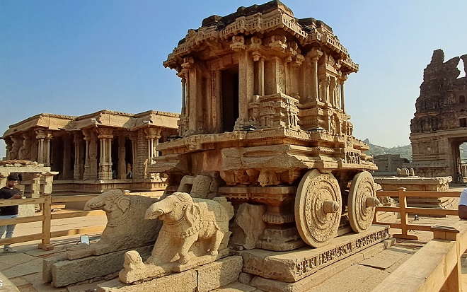 विजय-विठ्ठल
मंदिरातील रथशिल्प म्हणजे हंपीची जगातील ओळख आहे. बहामनी सुलतानांनी हंपी
उध्वस्त करणे सुरू केल्यावर या रथशिल्पाचीही तोडफोड केली. आजही ही
तोडफोडीची चिन्हे बघायला मिळताते आणि त्यानंतरही हे अद्भुत रथशिल्प बऱ्याच
प्रमाणात शाबूत राहिले आहे. या रथाव्यतिरिक्त इतर अनेक मंदिरे, सभागृह
विजय-विठ्ठल मंदिर परिसरात आहेत. ‘रंगमंडप’ हा तर खास द्रवीड
स्थापत्यशैलीचा आविष्कार आहे. वाद्यांचे आणि संगीताचे आवाज उत्पन्न
करणाऱ्या खांबाची रचना बघण्यासारखी आहे. एकेक खांब उत्तम शिल्पकलेने नटला
आहे. या सभागृहात नृत्य किंवा इतर कला सादर केल्या जात असत. यासाठी आवश्यक
असणाऱ्या ध्वनिशास्त्राचा अभ्यास येथे केला होता.
विजय-विठ्ठल
मंदिरातील रथशिल्प म्हणजे हंपीची जगातील ओळख आहे. बहामनी सुलतानांनी हंपी
उध्वस्त करणे सुरू केल्यावर या रथशिल्पाचीही तोडफोड केली. आजही ही
तोडफोडीची चिन्हे बघायला मिळताते आणि त्यानंतरही हे अद्भुत रथशिल्प बऱ्याच
प्रमाणात शाबूत राहिले आहे. या रथाव्यतिरिक्त इतर अनेक मंदिरे, सभागृह
विजय-विठ्ठल मंदिर परिसरात आहेत. ‘रंगमंडप’ हा तर खास द्रवीड
स्थापत्यशैलीचा आविष्कार आहे. वाद्यांचे आणि संगीताचे आवाज उत्पन्न
करणाऱ्या खांबाची रचना बघण्यासारखी आहे. एकेक खांब उत्तम शिल्पकलेने नटला
आहे. या सभागृहात नृत्य किंवा इतर कला सादर केल्या जात असत. यासाठी आवश्यक
असणाऱ्या ध्वनिशास्त्राचा अभ्यास येथे केला होता.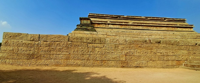 विजयनगरचे
साम्राज्य हे दक्षिण भारतातील सामर्थ्यशाली आणि श्रीमंत साम्राज्य होते.
हंपीच्या उत्खननात बाहेर आलेल्या अनेक महाप्रचंड वास्तू आपल्याला त्या
साम्राज्याच्या वैभवशाली काळाची आठवण करून देतात. तुंगभद्रा नदीच्या काठी
वसलेल्या या शहराच्या भव्यतेची जाणिव करून देणारे अवशेष जिथे आपल्याला
बघायला मिळतात, अशी एक वास्तू म्हणजे महानवमी डिब्बा. भल्या विस्तीर्ण
जागेवर उभी असलेली ही वास्तू म्हणजे एका अर्थाने राजदरबारच आहे. महानवमी
किंवा दसर्याचा उत्सव या ठिकाणी साजरा होत असे. आजच्या काळातील एखादी १००
घरांची कॉलनी सामावली जावी इतका मोठा हा सगळा परिसर आहे.
विजयनगरचे
साम्राज्य हे दक्षिण भारतातील सामर्थ्यशाली आणि श्रीमंत साम्राज्य होते.
हंपीच्या उत्खननात बाहेर आलेल्या अनेक महाप्रचंड वास्तू आपल्याला त्या
साम्राज्याच्या वैभवशाली काळाची आठवण करून देतात. तुंगभद्रा नदीच्या काठी
वसलेल्या या शहराच्या भव्यतेची जाणिव करून देणारे अवशेष जिथे आपल्याला
बघायला मिळतात, अशी एक वास्तू म्हणजे महानवमी डिब्बा. भल्या विस्तीर्ण
जागेवर उभी असलेली ही वास्तू म्हणजे एका अर्थाने राजदरबारच आहे. महानवमी
किंवा दसर्याचा उत्सव या ठिकाणी साजरा होत असे. आजच्या काळातील एखादी १००
घरांची कॉलनी सामावली जावी इतका मोठा हा सगळा परिसर आहे.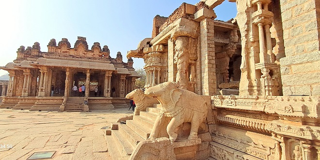 राज्यातील
मुत्सद्दी आणि हेर यांना गुप्त चर्चा करण्यासाठी तळघरात स्वतंत्र व्यवस्था
करण्यात आली आहे. या बंदिस्त जागेत हवा खेळती राहावी आणि कक्ष थंड राहावा
याचा विचार करून रचना केलेली दिसून येते. हा कक्षदेखील मंदिराच्याच
स्वरुपात बांधण्यात आला आहे. मंदिर वास्तुरचनेचा हा आणखी एक उपयोग. शिवाय,
उत्तम दगडी बांधकाम केलेली पुष्करणीही याच परिसराचा भाग आहे. आज पडझड
झालेले आणि बहामनी सुलतानांनी उध्वस्त केलेले अवशेषही येथे दिसून येतात.
राजाला गुप्त संदेश देण्यासाठी केलेली दगडी हत्तींची रचना ही ध्वनी आणि
भौतिकशास्त्राचे तत्कालिन भारतीय़ांचे ज्ञान सिद्ध करणारी आहे.
राज्यातील
मुत्सद्दी आणि हेर यांना गुप्त चर्चा करण्यासाठी तळघरात स्वतंत्र व्यवस्था
करण्यात आली आहे. या बंदिस्त जागेत हवा खेळती राहावी आणि कक्ष थंड राहावा
याचा विचार करून रचना केलेली दिसून येते. हा कक्षदेखील मंदिराच्याच
स्वरुपात बांधण्यात आला आहे. मंदिर वास्तुरचनेचा हा आणखी एक उपयोग. शिवाय,
उत्तम दगडी बांधकाम केलेली पुष्करणीही याच परिसराचा भाग आहे. आज पडझड
झालेले आणि बहामनी सुलतानांनी उध्वस्त केलेले अवशेषही येथे दिसून येतात.
राजाला गुप्त संदेश देण्यासाठी केलेली दगडी हत्तींची रचना ही ध्वनी आणि
भौतिकशास्त्राचे तत्कालिन भारतीय़ांचे ज्ञान सिद्ध करणारी आहे.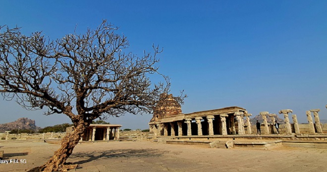 भल्या
सकाळी, उजाडायच्या आधी आम्ही बाहेर पडलो, कारण आम्हाला सूर्योदय गाठायचा
होता. तॊ ही अंजनेय पर्वतावरून. हेच ते महाबली हनुमानाचे ठिकाण. येथूनच तो
लालकेशरी सूर्यबिंबाकडे झेपावला होता. त्या हनुमान जन्मस्थलावरून आम्हाला
सूर्य़ोदय बघायचा होता. आमचा रिक्षावाला अनिलकुमारच्या मार्गदर्शनात आम्ही
अंधारात अंजनेय पर्वताकडे निघालॊ. अनिलकुमारमध्ये दाक्षिणात्य चित्रपटात
दिसणारे कित्येक गुण होते. तो रिक्षाही अशाच खास स्टाइलमध्ये चालवायचा. आता
अंजनेय पर्वताकडे झेपावताना त्याच्यात मारुतीचेच गुण आले होते. अशा भन्नाट
वेगात अंजनेयाच्या पायथ्याशी पोहोचलो, मारुतीचे नाव घेतले आणि पर्वत
चढायला सुरुवात केली. साधारण अर्ध्या तासात माथ्यावर पोहोचलॊ. सूर्योदयाला
काही मिनिटे उरली होती. तरुण मुलांचा एक गट आमच्या आधी येऊन पोहोचला होता.
अंजनेयावरून समोरची पूर्व-पश्चिम वाहणारी लांबलचक तुंगभद्रा दिसत होती आणि
तिच्या पार क्षितिजावर होणार होता सूर्योदय. संपूर्ण हंपीचा आसमंत आम्ही
डोळ्यात साठवून घेत होता. आमच्यातील एकमेव ट्रेकर अभिषेक टेकडीच्या टोकाशी
असलेल्या खडकावर जाऊन बसला होता. टेकडी चढून लागलेली धाप कमी होईपर्यंत
पहिली सूर्यकिरणे आकाशात झेपावू लागली. सगळ्यांचे लक्ष सूर्योदयाकडे लागले
होते. अर्थातच या सूर्योदयाला हनुमंताचा संदर्भ होता. अवघ्या काही मिनिटात
केशरी सूर्यबिंब हळूहळू वर येऊ लागले. अंजनेय पर्वतावर सूर्योदय झाला. आणि
पहिल्या किरणांबरोबरच अवतीभवती लहान-मोठी कितीतरी माकडे जमा झाली.
हनुमंताचे दूत.
भल्या
सकाळी, उजाडायच्या आधी आम्ही बाहेर पडलो, कारण आम्हाला सूर्योदय गाठायचा
होता. तॊ ही अंजनेय पर्वतावरून. हेच ते महाबली हनुमानाचे ठिकाण. येथूनच तो
लालकेशरी सूर्यबिंबाकडे झेपावला होता. त्या हनुमान जन्मस्थलावरून आम्हाला
सूर्य़ोदय बघायचा होता. आमचा रिक्षावाला अनिलकुमारच्या मार्गदर्शनात आम्ही
अंधारात अंजनेय पर्वताकडे निघालॊ. अनिलकुमारमध्ये दाक्षिणात्य चित्रपटात
दिसणारे कित्येक गुण होते. तो रिक्षाही अशाच खास स्टाइलमध्ये चालवायचा. आता
अंजनेय पर्वताकडे झेपावताना त्याच्यात मारुतीचेच गुण आले होते. अशा भन्नाट
वेगात अंजनेयाच्या पायथ्याशी पोहोचलो, मारुतीचे नाव घेतले आणि पर्वत
चढायला सुरुवात केली. साधारण अर्ध्या तासात माथ्यावर पोहोचलॊ. सूर्योदयाला
काही मिनिटे उरली होती. तरुण मुलांचा एक गट आमच्या आधी येऊन पोहोचला होता.
अंजनेयावरून समोरची पूर्व-पश्चिम वाहणारी लांबलचक तुंगभद्रा दिसत होती आणि
तिच्या पार क्षितिजावर होणार होता सूर्योदय. संपूर्ण हंपीचा आसमंत आम्ही
डोळ्यात साठवून घेत होता. आमच्यातील एकमेव ट्रेकर अभिषेक टेकडीच्या टोकाशी
असलेल्या खडकावर जाऊन बसला होता. टेकडी चढून लागलेली धाप कमी होईपर्यंत
पहिली सूर्यकिरणे आकाशात झेपावू लागली. सगळ्यांचे लक्ष सूर्योदयाकडे लागले
होते. अर्थातच या सूर्योदयाला हनुमंताचा संदर्भ होता. अवघ्या काही मिनिटात
केशरी सूर्यबिंब हळूहळू वर येऊ लागले. अंजनेय पर्वतावर सूर्योदय झाला. आणि
पहिल्या किरणांबरोबरच अवतीभवती लहान-मोठी कितीतरी माकडे जमा झाली.
हनुमंताचे दूत.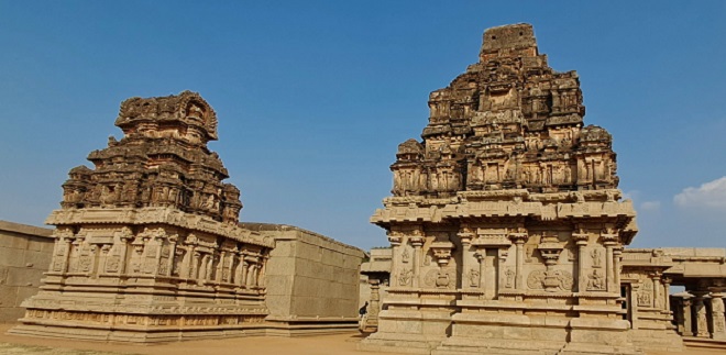 पौराणिक
राम मग मध्ययुगातही जपला गेला. विजयनगर साम्राज्यातील राजांनी तो
ठिकठिकाणी सांभाळून ठेवला. पण, यातही लक्षणीय़ आहे ते हजारी राम मंदिर. खास
हंपी शैलीत बांधलेल्या या मंदिरात संपूर्ण रामायण दगडांवर कोरलेले आहे.
कलाकुसर केलेल्या खांबांनी तोलून धरलेला सभामंडप आणि इमारतीच्या बाह्य
भागावर रामायणातील कथा सांगणारी शिल्पे. किती शिल्पे? तर तब्बल एक हजार.
त्यापैकी अनेक अजूनही टिकून आहेत. उत्तरेचा राम दक्षिणेने जपल्याचे आणि
भारताच्या या सांस्कृतिक एकसंधतेचा दाखला देत हे हजारी राम मंदिर आजही उभे
आहे.
पौराणिक
राम मग मध्ययुगातही जपला गेला. विजयनगर साम्राज्यातील राजांनी तो
ठिकठिकाणी सांभाळून ठेवला. पण, यातही लक्षणीय़ आहे ते हजारी राम मंदिर. खास
हंपी शैलीत बांधलेल्या या मंदिरात संपूर्ण रामायण दगडांवर कोरलेले आहे.
कलाकुसर केलेल्या खांबांनी तोलून धरलेला सभामंडप आणि इमारतीच्या बाह्य
भागावर रामायणातील कथा सांगणारी शिल्पे. किती शिल्पे? तर तब्बल एक हजार.
त्यापैकी अनेक अजूनही टिकून आहेत. उत्तरेचा राम दक्षिणेने जपल्याचे आणि
भारताच्या या सांस्कृतिक एकसंधतेचा दाखला देत हे हजारी राम मंदिर आजही उभे
आहे.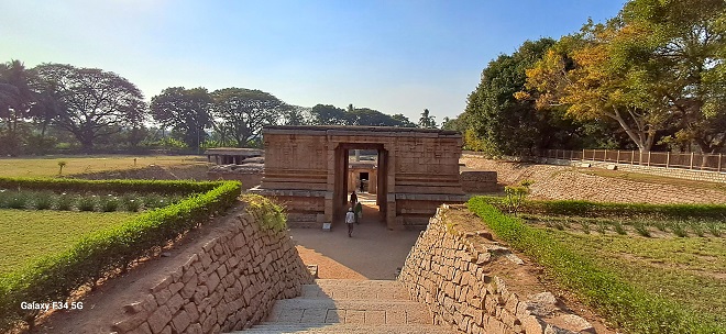 विरुपाक्ष
मंदिराच्या आतील भागात, रंग मंडपाच्या छतावर शिव-पार्वतीचा विवाह, शिवाशी
संबंधित कथा आणि रामायण व महाभारतातील कथा यांवर आधारित चित्रे रेखाटण्यात
आली आहेत. विजयनगर साम्राज्य वैभवाच्या कळसावर असताना सुमारे ५००
वर्षांपूर्वी ही चित्रे रेखाटली गेली आहेत. शैव आणि वैष्णव परंपरांमधील वाद
अधोरेखित करून दाखविण्याची आपल्याकडे पद्धत आहे. मात्र, हे दोन्ही
संप्रदाय एकत्रितपणे नांदण्याचे उदाहरणही ही चित्रे दर्शवितात. बाहेरच्या
भागात कृष्णदेवरायाने लावलेला शिलालेख आहे.
विरुपाक्ष
मंदिराच्या आतील भागात, रंग मंडपाच्या छतावर शिव-पार्वतीचा विवाह, शिवाशी
संबंधित कथा आणि रामायण व महाभारतातील कथा यांवर आधारित चित्रे रेखाटण्यात
आली आहेत. विजयनगर साम्राज्य वैभवाच्या कळसावर असताना सुमारे ५००
वर्षांपूर्वी ही चित्रे रेखाटली गेली आहेत. शैव आणि वैष्णव परंपरांमधील वाद
अधोरेखित करून दाखविण्याची आपल्याकडे पद्धत आहे. मात्र, हे दोन्ही
संप्रदाय एकत्रितपणे नांदण्याचे उदाहरणही ही चित्रे दर्शवितात. बाहेरच्या
भागात कृष्णदेवरायाने लावलेला शिलालेख आहे.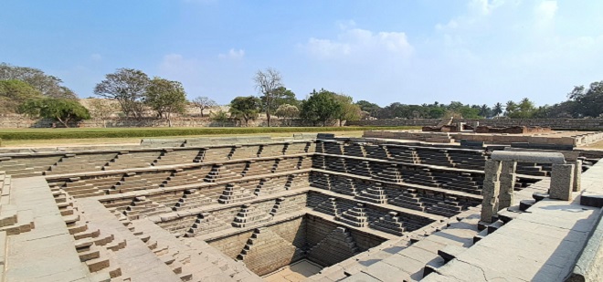


.jpg)


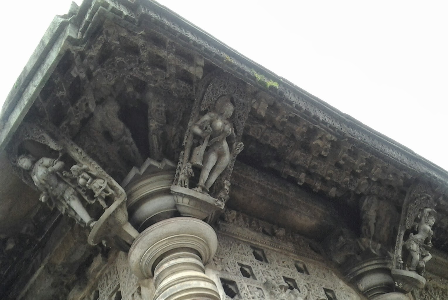


 बेलूर येथील चेन्नकेशव मंदिर हे आम्ही आजवर पाहिलेल्या मंदिरातील सर्वोत्कृष्ट मंदिर. हे होयसळ
वास्तुकलेचे प्रतीक आहे. या मंदिराचे वैशिष्ट्य म्हणजे या मंदिराच्या
बाह्य भागावर असंख्य मूर्ती कोरलेल्या आहेत. यात रामायण, महाभारत व विविध
पुराणातील कथा दर्शविणाऱ्या मूर्त्यांची रेलचेल आहे. पण हे मंदिर प्रसिद्ध
आहे ते त्याच्या छताजवळील भागावर कोरलेल्या उत्कृष्ट नर्तक / नर्तिका
यांच्या मूर्त्यांसाठी. याना शिला बालिका, मदनिका अथवा सुरसुंदऱ्या म्हणता
येईल. या मंदिरात असलेल्या एकूण अशा ४२ (बाहेर ३८ व आत ४) उत्कृष्ट कलाकृती
आपले लक्ष छताकडे वेधून घेतात. या आकृत्यांच्या कोरीव कामात होयसाळ
राजघराण्याच्या शिल्पकलेतील उच्च दर्जाची परिपूर्णता आपण पाहू शकतो. या
सुंदर छतावरील शिल्पकृती एका विशिष्ट प्रकारच्या दगडात कोरलेल्या आहेत,
ज्याला स्थानिक भाषेत बालापद कल्लू (सोपस्टोन) म्हणतात
बेलूर येथील चेन्नकेशव मंदिर हे आम्ही आजवर पाहिलेल्या मंदिरातील सर्वोत्कृष्ट मंदिर. हे होयसळ
वास्तुकलेचे प्रतीक आहे. या मंदिराचे वैशिष्ट्य म्हणजे या मंदिराच्या
बाह्य भागावर असंख्य मूर्ती कोरलेल्या आहेत. यात रामायण, महाभारत व विविध
पुराणातील कथा दर्शविणाऱ्या मूर्त्यांची रेलचेल आहे. पण हे मंदिर प्रसिद्ध
आहे ते त्याच्या छताजवळील भागावर कोरलेल्या उत्कृष्ट नर्तक / नर्तिका
यांच्या मूर्त्यांसाठी. याना शिला बालिका, मदनिका अथवा सुरसुंदऱ्या म्हणता
येईल. या मंदिरात असलेल्या एकूण अशा ४२ (बाहेर ३८ व आत ४) उत्कृष्ट कलाकृती
आपले लक्ष छताकडे वेधून घेतात. या आकृत्यांच्या कोरीव कामात होयसाळ
राजघराण्याच्या शिल्पकलेतील उच्च दर्जाची परिपूर्णता आपण पाहू शकतो. या
सुंदर छतावरील शिल्पकृती एका विशिष्ट प्रकारच्या दगडात कोरलेल्या आहेत,
ज्याला स्थानिक भाषेत बालापद कल्लू (सोपस्टोन) म्हणतात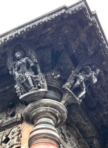 . या कोरीव कामासाठी वापरलेले हे दगड सुरुवातीला मऊ असतात आणि नंतर वातावरणाच्या प्रभावामुळे ते कठीण होतात. या आकृत्यांची उंची सुमारे अडीच फूट आहे.
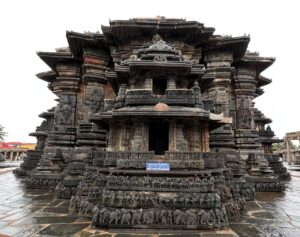 हेरील
भागावर जी इतर असंख्य सुंदर शिल्पे आहेत यात विष्णूची , शिवाची विविध रुपे
, अवतार व त्यांच्या कथा आपल्याला पाहायला मिळतात. काही शिल्पे कशी बनवली
असतील याचाही अचंबा वाटतो. रामायण महाभारतातील अनेक प्रसंग देखील आपल्याला
येथे आढळतात.
हेरील
भागावर जी इतर असंख्य सुंदर शिल्पे आहेत यात विष्णूची , शिवाची विविध रुपे
, अवतार व त्यांच्या कथा आपल्याला पाहायला मिळतात. काही शिल्पे कशी बनवली
असतील याचाही अचंबा वाटतो. रामायण महाभारतातील अनेक प्रसंग देखील आपल्याला
येथे आढळतात.


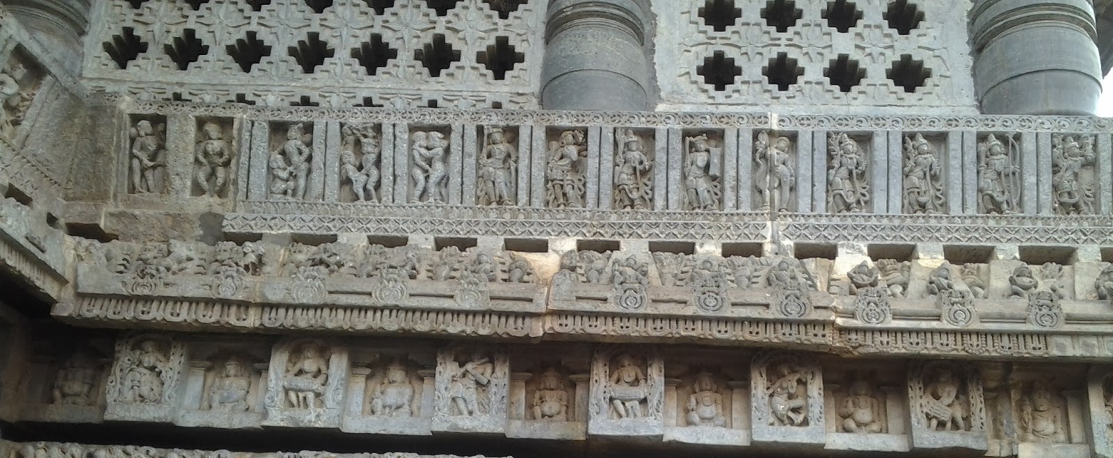


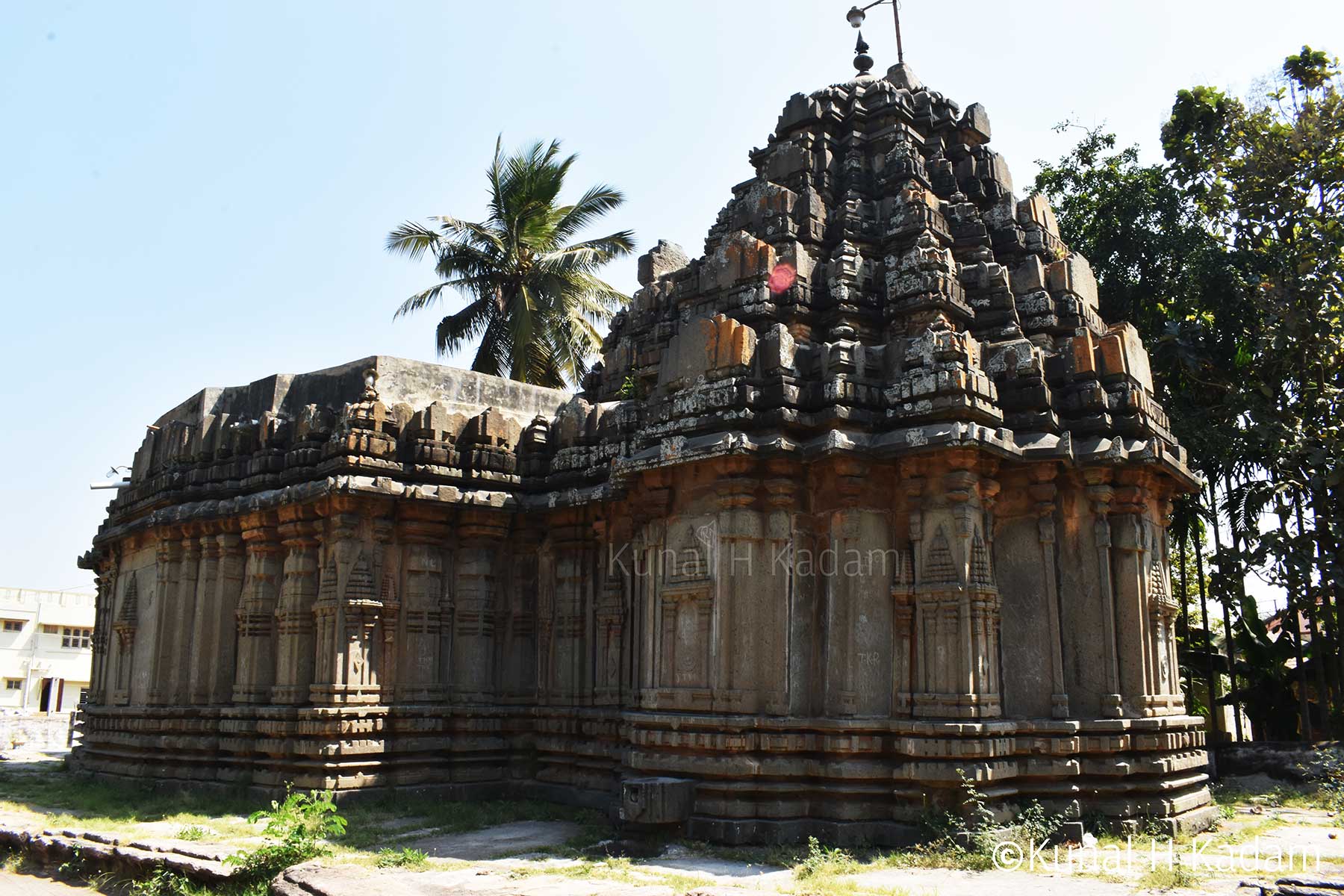


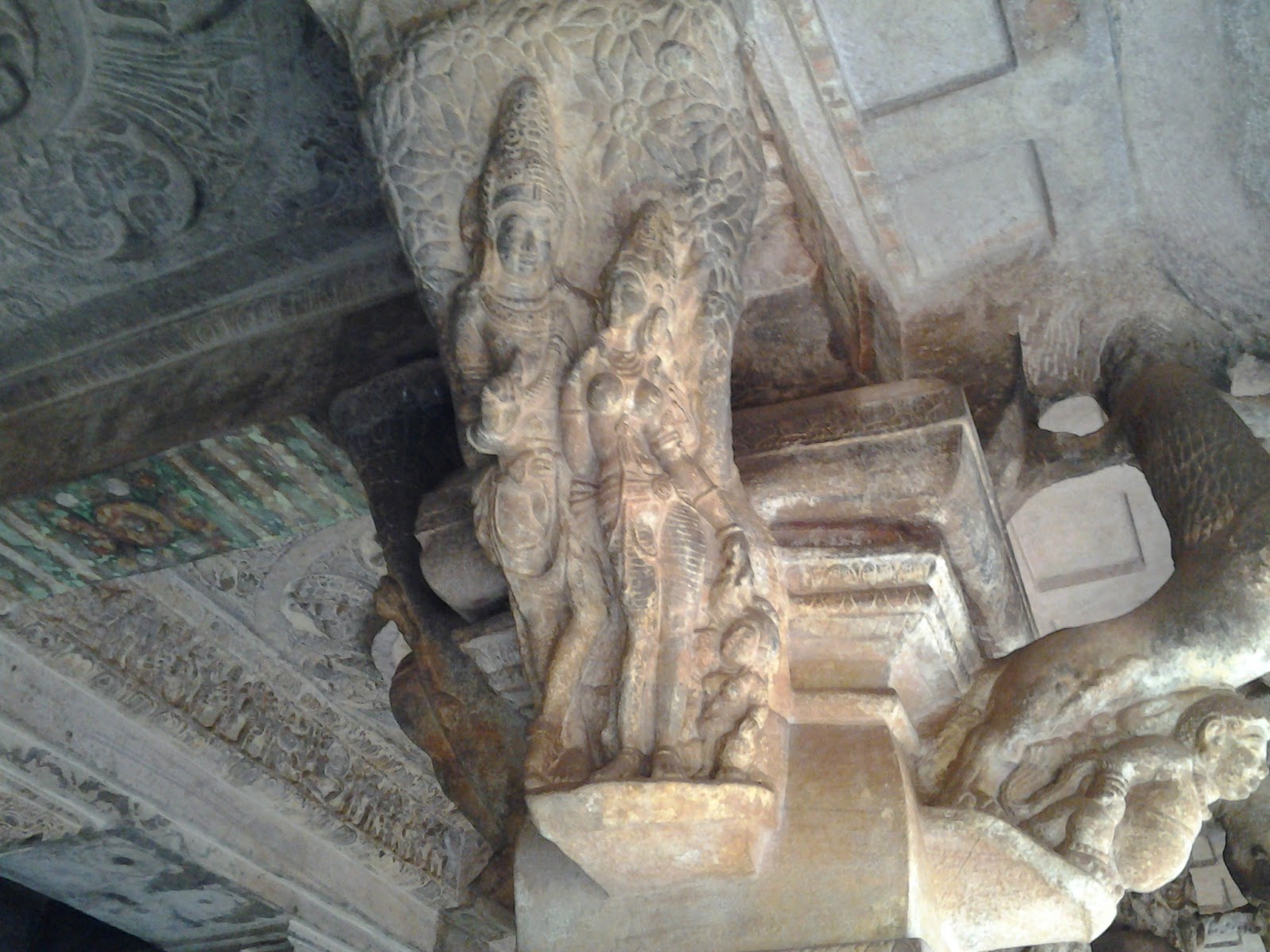


.jpg)


No comments:
Post a Comment
Note: Only a member of this blog may post a comment.