
>> वर्षा चोपडे
पालघाटचा किल्ला तथा पालक्कड किल्ला किंवा टिपूचा किल्ला केरळमधील
पर्यटनस्थळांमध्ये महत्त्वाचे fिठकाण आहे. पालक्कड या शहराला ‘केरळचे धान्य
कोठार’ असेही म्हणतात. पूर्वीच्या काळी पालक्कडला पालक्कट्टुसेरी म्हणूनही
ओळखले जात असे. असे मानतात की, पालक्कड हे नाव ‘पाल’ या देशी झाडापासून
आले आहे, ज्याने एकेकाळी पालक्कडची जमीन व्यापली होती. म्हणूनच हे पालक्कड
किंवा ‘पाल वृक्षांचे जंगल’.
?पालक्कडचा प्राचीन इतिहास गूढतेने व्यापलेला आहे. ‘मलबार मॅन्युअल’चे
लेखक विल्यम लोगन यांच्या मते, कांचीच्या पल्लव राजघराण्याने इसवी सनाच्या
दुसऱ्या किंवा तिसऱ्या शतकात मलबारवर आाढमण केले असावे. त्यांच्या
मुख्यालयांपैकी एक ‘पालकडा’ नावाचे ठिकाण होते जे सध्याचे पालक्कड असू
शकते. पालक्कड जिह्याच्या निर्मितीपूर्वी सध्याचा पालक्कड जिल्हा मलबार
जिह्याचा एक भाग होता. कोईम्बतूरच्या आसपासच्या प्रदेशावर संगम काळात
चेरांचे राज्य होते. इ.स.चे पहिले आणि चौथे शतक मलबार किनारा आणि
तामीळनाडूदरम्यानचा प्रमुख व्यापारी मार्ग होता व पालक्कडचे पूर्वेकडील
प्रवेशद्वार होते. भरतपुझा नदीच्या उत्तरेकडील तीरावर वसलेल्या पालक्कड
शहरावर राजा तरूर स्वरूपम यांनी राज्य केले. पालक्कड, अलाथूर आणि चित्तूर
या तालुक्यांवर पालक्कड राजाचा अधिकार होता. पालक्कड राजांचे मूळ मुख्यालय
सध्याच्या मलप्पुरम जिह्यातील अथवानद, थिरूर तालुक्यांत होते.
पुढे पालक्कडचा काही भाग काही काळ झामोरिन राजाच्या ताब्यात गेला होता.
1757 मध्ये कोझिकोडच्या झामोरिनच्या आाढमणाचा प्रतिकार करण्यासाठी पालक्कड
राजाने पुढे पालक्कडचा राजा पलिअम स्वरूपम याने मैसूरचे फौजदार हैदरअलीची
मदत घेतली. 1766 मध्ये हैदरअलीने कोझिकोडच्या झामोरिनचा पराभव केला.
हैदरअलीने 1766 मध्ये पालक्कड किल्ला पुन्हा बांधला. केरळच्या उत्तर
आणि उत्तर-मध्य भागांमधील मलबार जिह्याचा समावेश असलेली लहान संस्थाने
मैसूरच्या शासकांखाली एकत्र करण्यात आली आणि त्यांना मोठय़ा राज्याचा एक भाग
बनवण्यात आले. टिपू सुलतानचे वडील हैदरअली हे मैसूरच्या वोडेयार
शासकांच्या अंतर्गत काम करीत. उत्तराधिकारी टिपू सुलतान याने विस्तारत
असलेल्या ब्रिटिश ईस्ट इंडिया कंपनीविरुद्ध मोहिमा सुरू केल्या. त्याने
ब्रिटिश वसाहती विस्ताराचा तीव्र प्रतिकार केला. किल्ल्यात प्रवेश केल्यावर
हनुमान मंदिर आहे. या मंदिरात टिपू आणि त्याच्या योद्धय़ांनी पूजा केल्याचे
सांगितले जाते. तिसऱ्या अँग्लो-मैसूर युद्धात त्याचा पराभव झाला. किल्ला
मजबूत आणि प्रशस्त आहे. किल्ल्याव्यतिरिक्त येथे पुरातत्त्व सर्वेक्षण
भारतीय माहिती केंद्र संग्रहालयाचे संरक्षित स्मारक, पायऱ्यांची विहीर,
जुने जेल घर, पाण्याची तळे, सभागृह आहे.
पूर्वी हा किल्ला एक महत्त्वाचे लष्करी तळ होते.
18 व्या शतकात हैदरअलीने पुन्हा बांधला. किल्ला इंग्रजांच्या ताब्यात
येईपर्यंत मैसूरच्या अधिपत्याखाली होता. ब्रिटिशांच्या काळात सरकारी सेवा
देण्यासाठी त्याचा वापर केला जात असे. सेनापती हैदरचा मुलगा टिपू सुलतान
याच्या नावावर असलेले हे आज एक महत्त्वाचे ऐतिहासिक ठिकाण आहे. हा दक्षिण
हिंदुस्थानातील सर्वोत्तम संरक्षित किल्ल्यांपैकी एक आहे. भ्क्कम लॅटराइट
भिंती पर्यटकांना प्रभावित करतात. किल्ला आणि पालक्कड टाऊन
हॉलमध्ये असलेले मोठे मैदान हे सार्वजनिक सभा आणि महत्त्वाच्या
कार्पामांसाठी महत्त्वाचे ठिकाण आहे. आज हे भारतीय पुरातत्त्व
सर्वेक्षणाअंतर्गत संरक्षित स्मारक आहे. हा किल्ला बघणे फार सुंदर अनुभव
आहे. पालक्कडला भेट देणाऱ्या प्रत्येकासाठी हा एक पसंतीचे पिकनिक स्पॉट
आहे. या किल्ल्याव्यतिरिक्त पालक्कडच्या इतरही पर्यटनस्थळांना तुम्ही भेट
देऊ शकता.
(लेखिका राजगिरी कॉलेज ऑफ सोशल सायन्सेस, कोची, केरळच्या महाराष्ट्रातील संपर्क अधिकारी म्हणून नियुक्त आहेत.)
https://jogharshwardhan.blogspot.com/2014/11/long-drive-to-delhi-18-bekal-fort.html
Bekal Fort, Kasargod, Kerala
Thalassery Fort, Kannur, Kerala
Guruvayoor, Kerala
Guruvayoor Sri Krishna Temple is dedicated to Lord Krishna, an avtar of
Lord Vishnu. Temple is about 35 km from Trichur in Kerala. Main icon or
the Guruvayoorappan is a four armed Lord Krishna carrying conch,
Sudershan Chakra, mace & a lotus. It is also referred to as holy
abode of Lord Vishnu 'Bhuloka Vaikunta' or Dwarka of South India.
Strict routine of worship is followed here which had been laid down by
Adi Shankara. No mobiles cameras, trosers & shirts are allowed
inside. Only mundu or lungi is permitted for men. Non Hindus are not
permitted inside the sanctum.
One of the stories related to Guruvayoor is said to be mentioned in
Narad Purana. King Janmejaya ( who was son of King Parikshit who was son
of Abhimanyu who was son of Arjuna ) was suffering from leprosy. King
Janmejaya was advised by rishi Dattatreya to offer pooja at Guruvayoor.
The King recovered fully after ten months of worship.
Another legend goes like this: while Brahma was creating the universe,
Lord Vishnu made a statue of himself & gave it to Brahma for
salvation. It was passed on to devotees of Vishnu namely King Sutpass
& his queen Prasni with a boon that they shall have sons as avtars
in different Yugas. So the statue passed on as under:
- to Prasnigarbha who was born to King Sutpass & Prasani,
- to Vamana who was born to Rishi Kashyapa & Aditi,
- to Rama who was born to King Dashratha & Kaushalya &
- to Krishna who was born to Vasudeva & Devki.
Lord Krishna while leaving for heavens told Uddhav that after Him Dwarka
will be submerged & that the statue must be preserved & handed
over to Guru Brihaspati. Eventually Guru with the help of Vayu selected a
place near sea, having a forest, a lake with lotuses, birds &
animals. The statue was installed & consecrated here. Hence the
name of the place is Guruvayoor & name of the idol is
Guruvayoorappan. Some photos:
 |
| Temple town has a municipal office |
 |
| Garuda welcomes the devotees |
 |
| Long Q for darshan |
 |
| Pathway leading to the Temple |
 |
| Front view |
 |
| Stay blessed |
 |
| Stay blessed |
Thrissur, Kerala
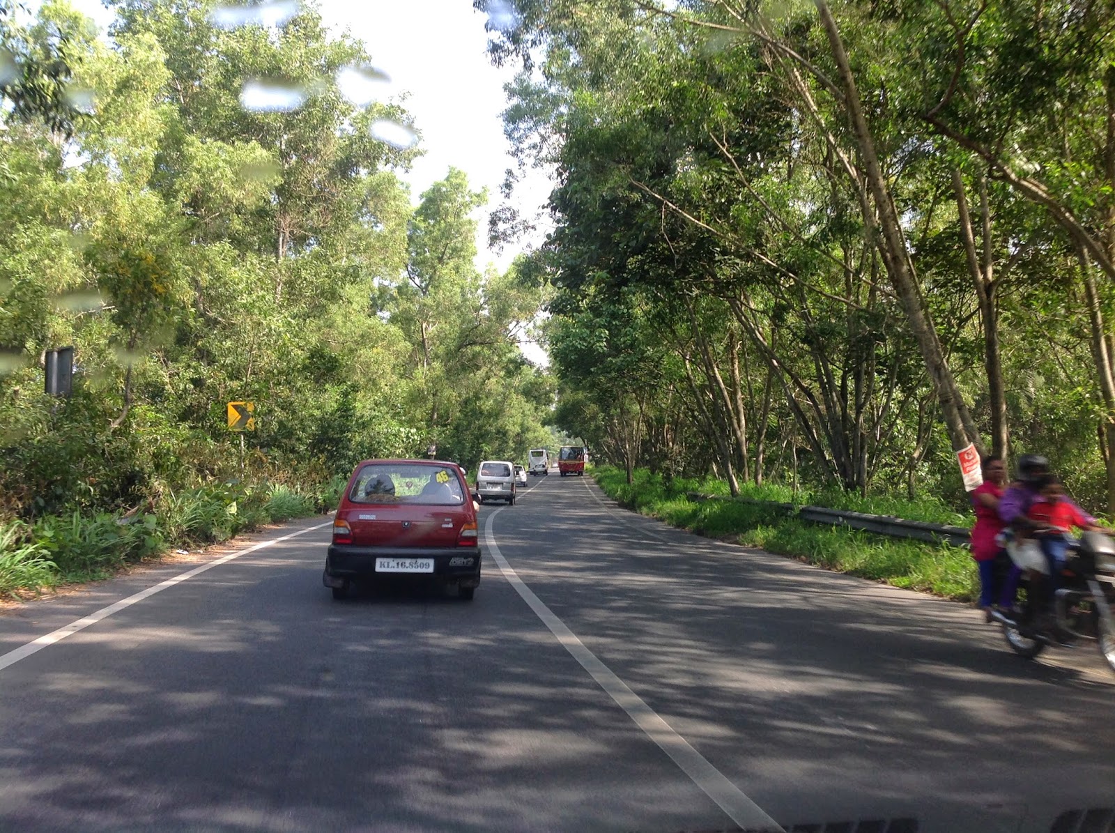
From Munnar we decided to go to Thrissur rather than to return back to
Kochi. Hilly route had lush green cover so soothing to eyes though Ghat
section is little tough due to heavy traffic, narrow road &
potholes. On reaching Thrissur we found it to be a pleasant mix of
ancient & modern cultures & architecture very appealing. Neat,
clean & looking prosperous, much better than most Indian cities.
Thrissur or Thichur is said to have original name as Thirusivapperoor.
Some say that Thrissur is shortened form of 'Thiru Shiva Perur' or Place
of Lord Shiva & another version is that it is derived from 'Thri
Shiva Perure' or Place of Three Shiva Temples - Vadakkumnathan Temple,
Kottapuram Temple & Poonkunnam Temple.
Some Christian writers claim that Thomas the Apostle landed in Muziris
near Thrissur in AD 51-52. Country's first mosque started in AD 629.
Thrissur has had Jews, Arabs, Romans, Portuguese, Dutch & English.
As of now Hindu population is around 50%. Interesting to note that it
has sent Congress 6 times & CPI 9 times to Lok Sabha.
City is 75 km north-east of Kochi & has an average altitude of 3
mtr. The temperature ranges from 22 to 33 degrees annually. Average
annual rainfall is over 3000 mm. Hotels to suit all budgets are
available having variety of cuisine. Nice town to spend a couple of
days. Some photos:
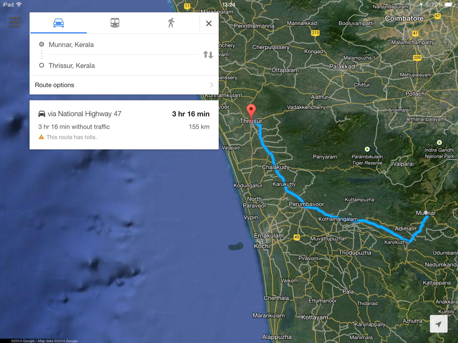 |
| Satellite
photo shows hilly terrain & lush green surroundings. It was almost
six hours of enjoyable drive. Of course Ghat section has its own twists
& turns |
 |
| Exciting drive - dense green jungle, lonely road & signs warning you about wildlife! |
 |
| Town Hall & Public Library - neat, clean & quiet |
 |
| A lovely view from the window of the KTDC Hotel room |
 |
| Shakthan Thampuran Palace now a museum managed by ASI |
 |
Two such guns guard the entrance of the Palace
|
 |
Entrance to Our Lady of Lourdes Syro-Malabar Church
|
 |
| Our Lady of Lourdes Syro-Malabar Catholic Metropolitan Cathedral Church undergoing renovation |
 |
| Our Lady of
Dolours Syro-Malabar Catholic Basilica is in the middle of the town.
This is Asia's highest Church though could not be properly caught on the
mobile. On the day of visit the hall was full with people standing
along the walls & kids sitting on the floor even |
 |
| Inside the Basilica complex |
 |
| Inside the Thiruvambadi Sri Krishna Temple |
 |
| Thiruvambadi Sri Krishna Temple is the largest Krishna Temple in Kerala |
 |
| Vadakkunnthan Temple |
 |
| City of beautiful & well maintained temples |
Munnar, Kerala
From Fort Kochi we decided to go up to Munnar via NH 49 covering a
distance of 130 km. Kothamangalam was about 60 km but had heavy traffic
& thereafter hight started increasing & road started narrowing.
Almost took 6 hrs to reach Munnar as the road moves like a snake through
dense green jungle. But the lush green surroundings are pleasure to
watch.
To get out of city on to a highway is cumbersome exercise as sign boards
which are in local lingo are of no help. Then you have to look for an
auto driver, student or office goer who can understand Hindi or English
for guidance. GPS in mobile phone comes in handy in such a situation. At
times however, we had problem with GPS specially if traffic policeman
suddenly decides to make a city road one-way-only! Then there is the
problem of change in spelling of names of places - like Cochin becomes
Kochi! Pronunciation of South Indian names by Ms. GPS are sometimes not
understood & seem funny!
We always kept stock of biscuits, namkeen, honey, sprouted moong dal,
lemon & fruits in car as quality dhabas are less on these roads
& one is not sure to find a good one when you are in need of it. Of
course good filter 'kappee' can be had easily in most of southern India.
Munnar town is situated on Kannan Devan hills in district Idukki, Kerala
at an elevation of 1600 mtr. Winter temperature may go down to 5 &
in summer temperature may go up to 25, cool place indeed. Munnar town is
located at the confluence of three rivers Madhurapuzha, Nallathanni
& Kundaly. Nearest railhead is Ernakulam approx 140 km & nearest
airport is Cochin approx 105 km. Plenty of hotels & resorts to suit
your budget. Enjoyable hill station. Some photos:
 |
| On way up to Munnar - such single lane old fashioned bridges are common |
 |
View of Munnar town from hill top
|
 |
| Red flags, hammer & sickle signs can be seen along the road side |
 |
During & after monsoon many waterfalls are seen
|
 |
| Same waterfall as seen on the other side of the bridge |
 |
| Hills & tea bushes. Munnar has more than 50 large tea estates mostly owned by Tata group |
 |
In the tea garden. First tea sapling is said to have been planted in 1870
|
 |
| Another view of the tea gardens |
 |
Insecticide being sprayed on tea bushes
|
 |
| Road spiralling through tea estates |
 |
Tea bushes are pruned & kept at table level so that picking up tea leaves is easier
|
 |
| Break in journey - enjoy the greenery |
Around Fort Kochi, Kerala
Kochi or Cochin or 'Queen of Arabian Sea' is a part of Ernakulam
district & a major port on south-west coast by the Arabian Sea.
Average annual temperatures fluctuate between 22 to 32 degrees. This
region enjoys summer as well as winter monsoon & as a result of
which annual rainfall is over 3200 mm compared to 700 mm annually in
Delhi. Fort Kochi is water bound area or one can say it is floating in
'backwaters'. Kochi is only 2600 km away from Delhi!
Kochi is well connected by rail, roads, air & sea routes. It has
hotels, guest houses to fit in all types of budgets. Variety of food is
available & people are friendly & easy to talk to. Hindi is
understood. Wear light cotton clothes & be prepared for mosquitoes.
Roads are narrow & congested & need patient driving. Enjoy speed
boat rides in backwaters preferably in the mornings.
In ancient times Kochi was a trading centre of spices & was known to
Greeks & Romans. Jews are said to have settled here in 12th
century. Kochi was a fishing village granted to Portuguese in 1503 by
Raja of Kochi in return for their help in fighting his enemies. They
built Fort Emmanuel here. It remained in their possession for 160 years.
In 1683 Dutch captured the Fort & remained there for 112 years. In
1795 British captured the Fort & of course they left in 1947.
How does it feel - Firangis fighting between themselves on Indian soil for supremacy over Indians?
 |
Fort Kochi, Kochi, Arabian Sea, Ernakulam & NH 47 - sea water enters in to the land or land extends in to the sea water?
|
 |
Green routes - heading towards Kochi on NH 47. I would love to drive again only to view greenery!
|
 |
Green routes - near Fort Kochi
|
 |
Chinese Fishing Net near Fort Kochi
|
 |
| Chinese
fishing net. The net is submerged in the sea water with the help of
bamboo tripod. Ropes having stones tied up hold the net at desired
depth. Ropes are pulled down manually & the submerged net comes up
with the catch |
 |
| Memorial of the freedom struggle |
 |
| Park in the night in Fort area |
 |
| Cafes & restaurants in Fort area. Enjoy international cuisine |
 |
| Sea food dominates the menu here |
 |
| An antique shop in equally antique Jew Town! |
 |
| Old wholesale spice market on weekly off day. Kochi
as spice trading centre was known to Romans & Greeks in ancient
times. Then came Jews, Portuguese, Chinese, Dutch & English. Kochi
absorbed them all. |
 |
One of the shops in wholesale spice market
|
 |
Candles on sale near the gate of St Francis Church built in 1503. Said to be oldest European Church in India
|
 |
| Clock Tower of
Pardesi Synagogue. Entrance of the Jew Temple is on left with an entry
fee of Rs 10. It was built in 1344. Clock Tower is a subsequent addition |
 |
| Bazaar in Jew Town, shops selling garments, trinkets & antiques |
 |
| Cathedral church in Fort Kochi |
 |
| Dutch Cemetery |
 |
| Backwaters near Fort Kochi |
 |
| Island in backwaters |
https://www.thetrioshotel.com/
https://www.thetrioshotel.com/tips-to-find-best-hotel-for-budget-travellers/
https://www.thetrioshotel.com/best-luxury-hotel-rooms-in-kochi/
On way to Cochin
From Trivandrum or Thiruvananthapuram to Cochin or Kochi the distance is
nearly 220 km but feels like 440 km! We took NH 47 which is a part of
620 km long highway connecting Salem to Coimbtore, Kochi, Trivandrum
& Kanyakumari. This route is one of the busiest highways in India
with large percentage of trucks. We took a break for the night in a
Alleppy hotel.
In most of Kerala the roads are narrow & congested with heavy
traffic. Most of the terrain is hilly & there are large number of
bridges - narrow & old. Potholes & sudden intermittent rains
stall your speed. State is thickly populated along the highways &
patience in driving is called for. No one here likes to wear helmets or
seat belts & overloaded vehicles are common sight.
But of course these roads have greenest scenery as well!
 |
| Nice view on NH 47, though you wish that it was a 'proper' highway |
 |
| Water & greenery everywhere |
 |
| Some buildings are close to highways |
 |
| Churches & Hammer & Sickle signs are common sight |
 |
| Modern & old houses amidst the greenery |
 |
| Onam festival decoration |
 |
| In Kollam we headed for the beach. Clean India compaign has not reached there as yet! |
 |
| Beautiful mermaid was waiting for us at the beach! With clean surroundings it would have been more impressive |
Reached Trivandrum
Pysem Day: We reached Trivandrum via NH 47 on Onam festival day &
almost all establishments were closed though city streets were
decorated. On the entrance of Kerala Tourism hotel, they were selling
Pysem which is rice cooked in milk & sugar or jaggary. We had one kg
pack & that turned out to be our lunch & dinner for the day!
Trivandrum or Thiruvananthapuram or City of Lord Anantha is capital of
Kerala state. It's elevation is less than 10 meters and average
temperature ranges from 23 to 33 C. Rainfall is heavy 1700 mm
annually(Delhi 700 mm) & hence surroundings are lush green. It must
be one of the top green cities of India. It is well connected by roads,
rail & air with rest of India.
History of Thiruvnanthpurm as a trading centre of spices, ivory,
sandalwood etc goes back a thousand years BCE. During 1729 it was made
capital of Travancore State by Marthand Varma. It became capital of
Kerala state in Nov 1956.
Population of the city is less than 10 lacs. As in the case of other old
cities of India there are high rise buildings as well as small old
houses with tiled roofs. Old portion has become congested & chaotic
due to cars & bikes in commercial alleys. Newer portion or Capital
part of the town is cleaner but with dull looking government buildings.
Main attraction of the town is richest temple of the world - Sree
Padamnabhaswamy Temple right in the middle of the town constructed in
Dravidian style. Temple is devoted to Padamnabha or Lord Vishnu who
reclines over Anantha or Sheshnag.
Estimated assets of the Temple are US$ 19 billion. If antique value is
factored in, assets could be many times more. Out of six vaults, Vault B
is yet to be opened. Estimate of this vault done by Royal family in
1931 was Rs.12000 crores! Mind boggling figures there. Lots of legends,
stories, rituals & court cases add to the awe & endless debates
on what to do with assets.
I prayed there for a few moments for a tiny percentage only of yellow metal! Some photos:
 |
| NH 47
Kanyakumari to Trivandrum. Satellite map shows more greenery on left
side(Kerala) of Western Ghats. Tamilnadu is on right side of the map but
wrong side of Ghats! |
 |
| Welcome on Onam |
 |
| Onam special - Pysem on sale |
 |
On the streets
|
 |
| On the green streets |
 |
| On the left is
tall Gopuram of Sri Padmanabhaswamy Temple, world's richest temple. On
the right is king's palace in rust coloured tiles, most of which is used
for temple related functions now |
 |
| For entering in to Temple everybody needs to wear a lungi. You can have it in the above store for Rs 60. |
 |
| Shoes,
mobiles,cameras, trousers & even shirt is not permitted inside. I
had to take off the shirt also before entering the Temple |
 |
| Entrance to the Temple |
 |
Che Guvera
seems to be a popular figure here. As the taxi driver said - people here
are - Hindus, Christians, Muslims or Communists!
|
 |
| World's
richest Temple has a pond Padma Teertham. And on the other side of the
pond interestingly, is a memorial of Comrades EMS Nampoothiripad / AK
Gopalan |
 |
| Bus Terminal - neat & clean |
 |
| Waiting
for the bus. Gold jewellery is essential part of ladies get-up. Almost
60% of the street hoardings are related to jewellery. Lungis &
chappals are popular. People generally looked better off & are
friendly | |


.jpg)


No comments:
Post a Comment
Note: Only a member of this blog may post a comment.